National Register of Historic Places listings in Essex County, Vermont
This is a list of the National Register of Historic Places listings in Essex County, Vermont.
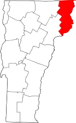
Location of Essex County in Vermont
This is intended to be a complete list of the properties and districts on the National Register of Historic Places in Essex County, Vermont, United States. Latitude and longitude coordinates are provided for many National Register properties and districts; these locations may be seen together in a map.[1]
There are 11 properties and districts listed on the National Register in the county.
- This National Park Service list is complete through NPS recent listings posted January 29, 2021.[2]
| Addison - Bennington - Caledonia - Chittenden - Essex - Franklin - Grand Isle - Lamoille - Orange - Orleans - Rutland - Washington - Windham - Windsor |
Current listings
| [3] | Name on the Register[4] | Image | Date listed[5] | Location | City or town | Description |
|---|---|---|---|---|---|---|
| 1 | Bloomfield-Nulhegan River Route 102 Bridge |  Bloomfield-Nulhegan River Route 102 Bridge |
November 14, 1991 (#91001605) |
VT 102 over the Nulhegan River 44°45′05″N 71°38′01″W |
Bloomfield | |
| 2 | Columbia Covered Bridge | 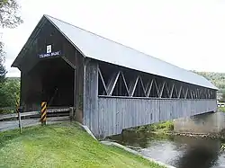 Columbia Covered Bridge |
December 12, 1976 (#76000123) |
Across the Connecticut River between U.S. Route 3 and VT 102 44°51′12″N 71°33′05″W |
Lemington | Extends into Coos County, New Hampshire |
| 3 | Guildhall Village Historic District | 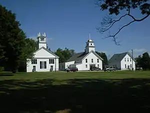 Guildhall Village Historic District |
September 27, 1980 (#80000331) |
VT 102 44°33′56″N 71°33′46″W |
Guildhall | |
| 4 | Judge David Hibbard Homestead | 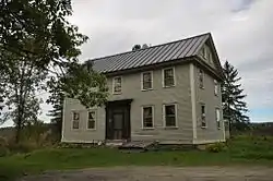 Judge David Hibbard Homestead |
March 31, 1995 (#95000294) |
Woodland Rd. 44°27′06″N 71°53′30″W |
Concord | |
| 5 | Island Pond Historic District | 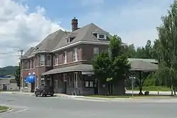 Island Pond Historic District |
January 31, 1979 (#79000275) |
Junction of VT 105 and VT 114 44°48′54″N 71°52′52″W |
Island Pond | |
| 6 | Jacobs Stand | 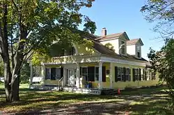 Jacobs Stand |
June 3, 1980 (#80000332) |
27 Park St. 44°59′45″N 71°32′23″W |
Canaan | Now the Alice M. Ward Library. |
| 7 | Maidstone State Park | 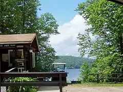 Maidstone State Park |
November 29, 2001 (#01001285) |
4858 and 4876 Maidstone Rd. 44°38′11″N 71°39′07″W |
Maidstone | |
| 8 | Mount Orne Covered Bridge | 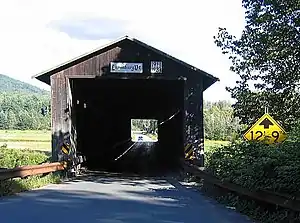 Mount Orne Covered Bridge |
December 12, 1976 (#76000124) |
East of Lunenburg off Town Hwy 1 44°27′38″N 71°39′12″W |
Lunenburg | Extends into Coos County, New Hampshire |
| 9 | U.S. Inspection Station-Canaan, Vermont | 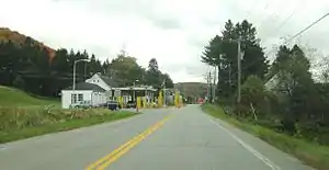 U.S. Inspection Station-Canaan, Vermont |
September 10, 2014 (#14000601) |
387 VT 141 45°00′43″N 71°33′36″W |
Canaan | |
| 10 | U.S. Inspection Station-Beecher Falls, Vermont | 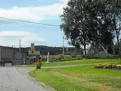 U.S. Inspection Station-Beecher Falls, Vermont |
September 10, 2014 (#14000602) |
1429 VT 253 45°00′46″N 71°30′22″W |
Canaan | |
| 11 | U.S. Inspection Station-Norton, Vermont | 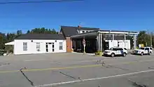 U.S. Inspection Station-Norton, Vermont |
September 10, 2014 (#14000603) |
115 VT 147N 45°00′37″N 71°47′39″W |
Norton |
See also
| Wikimedia Commons has media related to National Register of Historic Places in Essex County, Vermont. |
References
- The latitude and longitude information provided in this table was derived originally from the National Register Information System, which has been found to be fairly accurate for about 99% of listings. Some locations in this table may have been corrected to current GPS standards.
- "National Register of Historic Places: Weekly List Actions". National Park Service, United States Department of the Interior. Retrieved on January 29, 2021.
- Numbers represent an alphabetical ordering by significant words. Various colorings, defined here, differentiate National Historic Landmarks and historic districts from other NRHP buildings, structures, sites or objects.
- "National Register Information System". National Register of Historic Places. National Park Service. April 24, 2008.
- The eight-digit number below each date is the number assigned to each location in the National Register Information System database, which can be viewed by clicking the number.
| Topics | |
|---|---|
| Lists by state |
|
| Lists by insular areas | |
| Lists by associated state | |
| Other areas | |
| Related | |
| |
Municipalities and communities of Essex County, Vermont, United States | ||
|---|---|---|
| Towns | Map of Vermont highlighting Essex County | |
| CDPs | ||
| Grants and gores | ||
| Other communities | ||
| Footnotes | ‡ Unorganized | |
| ||
This article is issued from Wikipedia. The text is licensed under Creative Commons - Attribution - Sharealike. Additional terms may apply for the media files.