Lamanère
Lamanère (Catalan: La Menera) is a commune in the Pyrénées-Orientales department in southern France.
Lamanère
La Menera | |
|---|---|
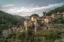 A general view of Lamanère | |
.svg.png.webp) Coat of arms | |
Location of Lamanère 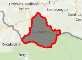
| |
 Lamanère  Lamanère | |
| Coordinates: 42°21′40″N 2°31′16″E | |
| Country | France |
| Region | Occitanie |
| Department | Pyrénées-Orientales |
| Arrondissement | Céret |
| Canton | Le Canigou |
| Intercommunality | Haut Vallespir |
| Government | |
| • Mayor (2008–2014) | Agnès Parayre |
| Area 1 | 23.83 km2 (9.20 sq mi) |
| Population (2017-01-01)[1] | 46 |
| • Density | 1.9/km2 (5.0/sq mi) |
| Time zone | UTC+01:00 (CET) |
| • Summer (DST) | UTC+02:00 (CEST) |
| INSEE/Postal code | 66091 /66230 |
| Elevation | 667–1,554 m (2,188–5,098 ft) (avg. 780 m or 2,560 ft) |
| 1 French Land Register data, which excludes lakes, ponds, glaciers > 1 km2 (0.386 sq mi or 247 acres) and river estuaries. | |
It is the southernmost village of Continental France.
Geography
Lamanère is located in the canton of Le Canigou and in the arrondissement of Céret.
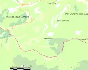
Map of Lamanère and its surrounding communes
Population
| Year | Pop. | ±% p.a. |
|---|---|---|
| 1968 | 113 | — |
| 1975 | 74 | −5.87% |
| 1982 | 60 | −2.95% |
| 1990 | 37 | −5.86% |
| 1999 | 44 | +1.94% |
| 2007 | 59 | +3.73% |
| 2012 | 51 | −2.87% |
| 2017 | 46 | −2.04% |
| Source: INSEE[2] | ||
See also
- Communes of the Pyrénées-Orientales department
- Bray-Dunes, the northernmost commune of Continental France
References
- "Populations légales 2017". INSEE. Retrieved 6 January 2020.
- Population en historique depuis 1968, INSEE
| Wikimedia Commons has media related to Lamanère (Pyrénées-Orientales). |
| Authority control |
|---|
This article is issued from Wikipedia. The text is licensed under Creative Commons - Attribution - Sharealike. Additional terms may apply for the media files.