Halifax County, Virginia
Halifax County is a county located in the Commonwealth of Virginia. As of the 2010 census, the population was 36,241.[2] Its county seat is Halifax.[3]
Halifax County | |
|---|---|
.jpg.webp) | |
 Seal | |
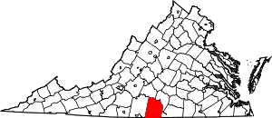 Location within the U.S. state of Virginia | |
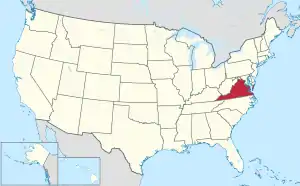 Virginia's location within the U.S. | |
| Coordinates: 36°46′N 78°56′W | |
| Country | |
| State | |
| Founded | 1752 |
| Named for | George Montague-Dunk, 2nd Earl of Halifax |
| Seat | Halifax |
| Largest town | South Boston |
| Area | |
| • Total | 830 sq mi (2,100 km2) |
| • Land | 818 sq mi (2,120 km2) |
| • Water | 12 sq mi (30 km2) 1.4% |
| Population (2010) | |
| • Total | 36,241 |
| • Estimate (2018)[1] | 34,120 |
| • Density | 44/sq mi (17/km2) |
| Time zone | UTC−5 (Eastern) |
| • Summer (DST) | UTC−4 (EDT) |
| Congressional district | 5th |
| Website | www |
History
Occupied by varying cultures of indigenous peoples for thousands of years, in historic times English colonists encountered Siouan-speaking Native Americans. Halifax County was established in 1752 by English colonists from Lunenburg County. The county was named for George Montague-Dunk, 2nd Earl of Halifax.
Through the 1990 Census, South Boston was an independent city, but it became a town again and rejoined Halifax County in 1995.
Geography
According to the U.S. Census Bureau, the county has a total area of 830 square miles (2,100 km2), of which 818 square miles (2,120 km2) is land and 12 square miles (31 km2) (1.4%) is water.[4]
Adjacent counties
- Campbell County - northwest
- Charlotte County - northeast
- Mecklenburg County - east
- Granville County, North Carolina - southeast
- Person County, North Carolina - south
- Caswell County, North Carolina - southwest
- Pittsylvania County - west
Demographics
| Historical population | |||
|---|---|---|---|
| Census | Pop. | %± | |
| 1790 | 14,722 | — | |
| 1800 | 19,377 | 31.6% | |
| 1810 | 22,133 | 14.2% | |
| 1820 | 19,060 | −13.9% | |
| 1830 | 28,034 | 47.1% | |
| 1840 | 25,936 | −7.5% | |
| 1850 | 25,962 | 0.1% | |
| 1860 | 26,520 | 2.1% | |
| 1870 | 27,828 | 4.9% | |
| 1880 | 33,588 | 20.7% | |
| 1890 | 34,424 | 2.5% | |
| 1900 | 37,197 | 8.1% | |
| 1910 | 40,044 | 7.7% | |
| 1920 | 41,374 | 3.3% | |
| 1930 | 41,283 | −0.2% | |
| 1940 | 41,271 | 0.0% | |
| 1950 | 41,442 | 0.4% | |
| 1960 | 33,637 | −18.8% | |
| 1970 | 30,076 | −10.6% | |
| 1980 | 30,599 | 1.7% | |
| 1990 | 29,033 | −5.1% | |
| 2000 | 37,355 | 28.7% | |
| 2010 | 36,241 | −3.0% | |
| 2018 (est.) | 34,120 | [1] | −5.9% |
| U.S. Decennial Census[5] 1790-1960[6] 1900-1990[7] 1990-2000[8] 2010-2012[2] | |||

As of the census[9] of 2000, there were 37,355 people, 15,018 households, and 10,512 families residing in the county. The population density was 46 people per square mile (18/km2). There were 16,953 housing units at an average density of 21 per square mile (8/km2). The racial makeup of the county was 60.32% White, 38.02% Black or African American, 0.20% Native American, 0.24% Asian, 0.01% Pacific Islander, 0.44% from other races, and 0.77% from two or more races. 1.23% of the population were Hispanic or Latino of any race.
There were 15,018 households, out of which 28.60% had children under the age of 18 living with them, 51.20% were married couples living together, 14.80% had a female householder with no husband present, and 30.00% were non-families. 27.40% of all households were made up of individuals, and 13.10% had someone living alone who was 65 years of age or older. The average household size was 2.43 and the average family size was 2.94.
In the county, the population was spread out, with 23.40% under the age of 18, 6.90% from 18 to 24, 26.40% from 25 to 44, 26.30% from 45 to 64, and 17.10% who were 65 years of age or older. The median age was 41 years. For every 100 females there were 90.80 males. For every 100 females age 18 and over, there were 86.70 males.
The median income for a household in the county was $29,929, and the median income for a family was $37,845. Males had a median income of $27,498 versus $20,684 for females. The per capita income for the county was $16,353. About 11.50% of families and 15.70% of the population were below the poverty line, including 18.90% of those under age 18 and 19.60% of those age 65 or over.
Government
Board of Supervisors
- District 1: Rick Short
- District 2: Jeffrey D Francisco
- District 3: Hubert Pannell
- District 4: Ronnie Duffey
- District 5: Dean Throckmorton
- District 6: Stanley Brandon
- District 7: Garland Ricketts
- District 8: William Bryant Claiborne
- Tie Breaker: Larry Roller
Constitutional officers
- Clerk of the Circuit Court: Cathy M. Cosby (I)
- Commissioner of the Revenue: Brenda P. Powell (I)
- Commonwealth's Attorney: Tracy Quackenbush Martin (I)
- Sheriff: Fred S. Clark (I)
- Treasurer: Ruth Ann Oakes (I)
Halifax is represented by Republicans Frank Ruff and Bill Stanley in the Virginia Senate, Republican James E. Edmunds in the Virginia House of Delegates, and Republican Denver Riggleman in the U.S. House of Representatives.
| Year | Republican | Democratic | Third parties |
|---|---|---|---|
| 2020 | 57.1% 10,418 | 42.0% 7,666 | 0.9% 164 |
| 2016 | 57.1% 9,704 | 40.6% 6,897 | 2.3% 393 |
| 2012 | 52.1% 8,694 | 46.5% 7,766 | 1.4% 232 |
| 2008 | 51.0% 8,600 | 48.2% 8,126 | 0.7% 124 |
| 2004 | 57.1% 8,363 | 42.4% 6,220 | 0.5% 73 |
| 2000 | 55.0% 7,732 | 42.4% 5,963 | 2.7% 377 |
| 1996 | 49.1% 6,490 | 42.3% 5,599 | 8.6% 1,137 |
| 1992 | 46.2% 5,199 | 42.2% 4,752 | 11.6% 1,311 |
| 1988 | 56.0% 5,671 | 42.3% 4,282 | 1.7% 171 |
| 1984 | 60.6% 6,726 | 38.1% 4,231 | 1.3% 146 |
| 1980 | 51.7% 5,088 | 46.0% 4,528 | 2.2% 220 |
| 1976 | 46.5% 4,045 | 50.0% 4,352 | 3.5% 300 |
| 1972 | 68.7% 5,469 | 30.0% 2,384 | 1.3% 106 |
| 1968 | 28.9% 2,634 | 24.2% 2,199 | 46.9% 4,269 |
| 1964 | 63.9% 3,928 | 35.8% 2,198 | 0.3% 18 |
| 1960 | 39.6% 1,784 | 59.4% 2,676 | 1.1% 48 |
| 1956 | 30.7% 1,782 | 42.6% 2,470 | 26.7% 1,547 |
| 1952 | 40.7% 2,274 | 59.0% 3,296 | 0.3% 17 |
| 1948 | 13.5% 521 | 34.2% 1,323 | 52.4% 2,026 |
| 1944 | 13.2% 512 | 86.6% 3,351 | 0.2% 7 |
| 1940 | 9.8% 373 | 89.9% 3,441 | 0.3% 12 |
| 1936 | 6.5% 302 | 93.3% 4,331 | 0.2% 9 |
| 1932 | 7.1% 275 | 91.9% 3,583 | 1.1% 43 |
| 1928 | 28.5% 1,091 | 71.5% 2,742 | |
| 1924 | 14.0% 374 | 84.2% 2,245 | 1.7% 46 |
| 1920 | 21.7% 586 | 78.0% 2,103 | 0.3% 8 |
| 1916 | 21.5% 493 | 77.7% 1,781 | 0.7% 17 |
| 1912 | 23.2% 426 | 68.6% 1,260 | 8.2% 150 |
Communities
Census-designated places
Other unincorporated communities
- Alton
- Cody
- Turbeville
- Vernon Hill
References
- "Population and Housing Unit Estimates". Retrieved July 14, 2019.
- "State & County QuickFacts". United States Census Bureau. Archived from the original on June 6, 2011. Retrieved January 3, 2014.
- "Find a County". National Association of Counties. Retrieved 2011-06-07.
- "US Gazetteer files: 2010, 2000, and 1990". United States Census Bureau. 2011-02-12. Retrieved 2011-04-23.
- "U.S. Decennial Census". United States Census Bureau. Retrieved January 3, 2014.
- "Historical Census Browser". University of Virginia Library. Retrieved January 3, 2014.
- "Population of Counties by Decennial Census: 1900 to 1990". United States Census Bureau. Retrieved January 3, 2014.
- "Census 2000 PHC-T-4. Ranking Tables for Counties: 1990 and 2000" (PDF). United States Census Bureau. Retrieved January 3, 2014.
- "U.S. Census website". United States Census Bureau. Retrieved 2011-05-14.
- "Board of Supervisors - Halifax County, VA". www.halifaxcountyva.gov. Retrieved 2018-08-20.
- Leip, David. "Dave Leip's Atlas of U.S. Presidential Elections". uselectionatlas.org. Retrieved 2020-12-09.
External links
- Official site of Halifax County & South Boston, Virginia
- History of Halifax County and South Boston, Virginia
- Official site of Town of South Boston - largest town within the County
- Official site of the County Museum
- Halifax County South Boston Public Library System
Places adjacent to Halifax County, Virginia | |
|---|---|
Municipalities and communities of Halifax County, Virginia, United States | ||
|---|---|---|
| Towns | Map of Virginia highlighting Halifax County | |
| CDPs | ||
| Unincorporated communities | ||
| Footnotes | ‡This populated place also has portions in an adjacent county or counties | |
| ||
| Authority control |
|---|