Frederick County, Virginia
Frederick County is located in the Commonwealth of Virginia. As of the 2010 census, the population was 78,305.[2] Its county seat is Winchester.[3] The county was formed in 1743 by the splitting of Orange County. It is Virginia's northernmost county.
Frederick County | |
|---|---|
County | |
 The Old Frederick County Courthouse in Winchester | |
 Seal | |
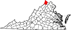 Location within the U.S. state of Virginia | |
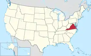 Virginia's location within the U.S. | |
| Coordinates: 39°13′N 78°16′W | |
| Country | |
| State | |
| Founded | 1743 |
| Named for | Frederick, Prince of Wales |
| Seat | Winchester |
| Largest town | Winchester |
| Area | |
| • Total | 416 sq mi (1,080 km2) |
| • Land | 414 sq mi (1,070 km2) |
| • Water | 2 sq mi (5 km2) 0.5% |
| Population (2010) | |
| • Total | 78,305 |
| • Estimate (2018)[1] | 88,355 |
| • Density | 190/sq mi (73/km2) |
| Time zone | UTC−5 (Eastern) |
| • Summer (DST) | UTC−4 (EDT) |
| Congressional district | 10th |
| Website | www |
Frederick County is included in the Winchester, VA-WV Metropolitan Statistical Area, which is also included in the Washington-Baltimore-Northern Virginia, DC-MD-VA-WV-PA Combined Statistical Area.
History
The area that would become Frederick County, Virginia was inhabited and transited by various indigenous peoples for thousands of years before European colonization. The "Indian Road" refers to a historic pathway made by local tribes.
Colonization efforts began with the Virginia Company of London, but European settlement did not flourish until after the company lost its charter and Virginia became a royal colony in 1624. In order to stimulate migration to the colony, the headright system was used. Under this system, those who funded an emigrant's transportation costs (not the actual colonizers) were compensated with land.[4] During the early 17th century, King Charles II granted several acres of colonial Virginia lands to “seven loyal supporters,” including Lord Fairfax. This passed to Thomas Fairfax, 5th Lord Fairfax of Cameron, who married the daughter of Thomas Colepeper, who also owned several acres of land. After their son, Lord Thomas Fairfax, inherited the combined grants, he controlled over 5,000,000 acres of land in Virginia, including much of the land that became Frederick County.[5]
Frederick County was created from Orange County in 1738, and was officially organized in 1743.[6] The Virginia Assembly named the new county for Frederick Louis, Prince of Wales[7] (1707–1751), the eldest son of King George II of Great Britain. At that time, "Old Frederick County" encompassed all or part of four counties in present-day Virginia and five in present-day West Virginia:
- Hampshire (West Virginia), created 1754
- Dunmore, created 1772 and renamed Shenandoah in 1778
- Berkeley (West Virginia), created 1772
- Hardy (West Virginia), created 1786
- Jefferson (West Virginia), created 1801
- Morgan (West Virginia), created 1820
- Page, created 1831
- Clarke, created 1836
- Warren, created 1836[6]
Colonial era
As Commander-in-Chief of the new Colonial Virginia regiment in 1754, Colonel George Washington located his headquarters in Winchester before and during the French and Indian War. He resigned from military service in 1758. He represented Frederick County in his first elective office, having been elected to the House of Burgesses in 1758 and 1761.
Seventeen years later, on June 15, 1775, the Continental Congress "elected" George Washington as commanding general of the yet-to-be-created Continental Army. He accepted the appointment the next day.[8] This preceded the Congress's declaration of independence and the outbreak of the American Revolutionary War.
American Civil War
Winchester was a site of volatile conditions during the Civil War, with control shifting between the Confederate and Union armies on average once every three weeks during the war. Many battles were fought in Frederick County. Some of those battles include:
- First Battle of Kernstown, March 1862
- First Battle of Winchester, May 1862
- Second Battle of Winchester, June 1863
- Second Battle of Kernstown, July 1864
- Third Battle of Winchester (Battle of Opequon), September 1864
- Battle of Cedar Creek, October 1864
The first constitution of West Virginia provided for Frederick County to be added to the new state if approved by a local election.[9] Unlike the residents of neighboring Berkeley and Jefferson counties, those in Frederick County voted to remain in Virginia, despite being occupied by the Union Army at the time.
Civilian history of the area
Four (alkaline, saline, chalybeate, and sulphured) types of mineral water springs naturally occur on the land that would later be named Rock Enon Springs.[10]:868 The area was once called Capper Springs, named for area settler John Capper.[11]:57 William Marker bought the 942 acres (381 ha) in 1856 and built a hotel, the first building of the Rock Enon Springs Resort. It survived the American Civil War.[12] On March 24, 1899 the Shenandoah Valley National Bank purchased the property for $3,500.[13]:9 During the summer of 1914 botanists found a variety of ferns on the property: polypodium vulgare, phegopteris hexagonoptera, adiantum pedatum, pteris aquilina, and cheilanthes lanosa on the property.[14]
The idea that soaking in the natural spring water had medical value made this and other springs popular tourist destinations through the early 20th century. [15]
In 1944, people no longer had as much faith in the springs, and there was much more competition for tourists at other sites. Due to declining business, the Glaize family sold the property to the Shenandoah Area Council. They adapted the resort to operate as a Boy Scout site, Camp Rock Enon.[12] In 1944 the 5 acres (0.020 km2) Miller Lake was created by adding a 200 feet (61 m) earth dam across Laurel Run using equipment, owned by the Federal fish hatchery in Leestown.[16]:M4 In 1958 "walnut, chestnut and persimmon trees" were planted on the property.[17]:50
Geography

According to the U.S. Census Bureau, the county has a total area of 416 square miles (1,080 km2), of which 414 square miles (1,070 km2) is land and 2 square miles (5.2 km2) (0.5%) is water.[18] This is the northernmost county in the Commonwealth of Virginia.
Adjacent counties
|
|
National protected areas
Demographics
| Historical population | |||
|---|---|---|---|
| Census | Pop. | %± | |
| 1790 | 19,681 | — | |
| 1800 | 24,744 | 25.7% | |
| 1810 | 22,574 | −8.8% | |
| 1820 | 24,706 | 9.4% | |
| 1830 | 26,046 | 5.4% | |
| 1840 | 14,242 | −45.3% | |
| 1850 | 15,975 | 12.2% | |
| 1860 | 16,546 | 3.6% | |
| 1870 | 16,596 | 0.3% | |
| 1880 | 17,553 | 5.8% | |
| 1890 | 17,880 | 1.9% | |
| 1900 | 13,239 | −26.0% | |
| 1910 | 12,787 | −3.4% | |
| 1920 | 12,461 | −2.5% | |
| 1930 | 13,167 | 5.7% | |
| 1940 | 14,008 | 6.4% | |
| 1950 | 17,537 | 25.2% | |
| 1960 | 21,941 | 25.1% | |
| 1970 | 28,893 | 31.7% | |
| 1980 | 34,150 | 18.2% | |
| 1990 | 45,723 | 33.9% | |
| 2000 | 59,209 | 29.5% | |
| 2010 | 78,305 | 32.3% | |
| 2019 (est.) | 89,313 | [19] | 14.1% |
| U.S. Decennial Census[20] 1790–1960[21] 1900–1990[22] 1990–2000[23] The drop from 1830 to 1840 was because Clarke and Warren counties were split off. | |||
As of the census[24] of 2000, there were 59,209 people, 22,097 households, and 16,727 families residing in the county. The population density was 143 people per square mile (55/km2). There were 23,319 housing units at an average density of 56/square mile (22/km2). The racial makeup of the county was 94.99% White, 2.62% Black or African American, 0.16% Native American, 0.66% Asian, 0.02% Pacific Islander, 0.56% from other races, and 1.01% from two or more races. 1.70% of the population were Hispanic or Latino of any race.
There were 22,097 households, out of which 36.60% had children under the age of 18 living with them, 62.50% were married couples living together, 8.80% had a female householder with no husband present, and 24.30% were non-families. 19.20% of all households were made up of individuals, and 6.80% had someone living alone who was 65 years of age or older. The average household size was 2.64 and the average family size was 3.02.
In the county, the population was spread out, with 26.40% under the age of 18, 7.00% from 18 to 24, 31.90% from 25 to 44, 24.10% from 45 to 64, and 10.60% who were 65 years of age or older. The median age was 37 years. For every 100 females, there were 100.10 males. For every 100 females age 18 and over, there were 96.70 males.
The median income for a household in the county was $46,941, and the median income for a family was $52,281. Males had a median income of $35,705 versus $25,046 for females. The per capita income for the county was $21,080. About 4.00% of families and 6.40% of the population were below the poverty line, including 7.30% of those under age 18 and 6.90% of those age 65 or over.
Government
Board of Supervisors
- Chairman: Charles S. DeHaven, Jr. (R)
- Back Creek District: Gary A. Lofton (R)
- Gainesboro District: Bill Ewing (R)
- Opequon District: Robert Wells (R)
- Red Bud District: Blaine P. Dunn (R)
- Shawnee District: Gene E. Fisher (R)
- Stonewall District: Judith McCann-Slaughter. (R)
Constitutional officers
- Clerk of the Circuit Court: Rebecca P. "Becky" Hogan (D)
- Commissioner of the Revenue: Ellen E. Murphy (R)
- Commonwealth's Attorney: Ross Spicer (R)
- Sheriff: Lenny Millholland (D)
- Treasurer: C. William Orndoff, Jr. (R)
Frederick is represented by Republican Jill Holtzman Vogel in the Virginia Senate, Wendy Gooditis (D), Chris Collins (R), and Dave LaRock (R) in the Virginia House of Delegates, and Jennifer Wexton (D) in the U.S. House of Representatives.
| Year | Republican | Democratic | Third parties |
|---|---|---|---|
| 2020 | 62.7% 30,558 | 35.3% 17,207 | 1.9% 938 |
| 2016 | 64.5% 26,083 | 29.5% 11,932 | 6.0% 2,425 |
| 2012 | 62.8% 22,858 | 34.9% 12,690 | 2.3% 846 |
| 2008 | 60.0% 20,149 | 38.6% 12,961 | 1.5% 502 |
| 2004 | 67.9% 19,386 | 31.0% 8,853 | 1.1% 301 |
| 2000 | 65.1% 14,574 | 32.0% 7,158 | 3.0% 660 |
| 1996 | 57.6% 10,608 | 32.5% 5,976 | 9.9% 1,828 |
| 1992 | 54.0% 9,425 | 28.3% 4,942 | 17.8% 3,101 |
| 1988 | 72.3% 9,921 | 27.0% 3,707 | 0.7% 89 |
| 1984 | 77.8% 9,542 | 21.8% 2,671 | 0.4% 54 |
| 1980 | 67.6% 7,293 | 27.3% 2,948 | 5.1% 546 |
| 1976 | 59.5% 5,162 | 39.1% 3,389 | 1.4% 121 |
| 1972 | 75.2% 5,367 | 22.5% 1,604 | 2.4% 168 |
| 1968 | 49.6% 3,696 | 21.6% 1,612 | 28.8% 2,146 |
| 1964 | 47.2% 2,585 | 52.6% 2,880 | 0.2% 9 |
| 1960 | 53.7% 2,061 | 45.8% 1,757 | 0.4% 17 |
| 1956 | 56.0% 1,882 | 41.8% 1,405 | 2.2% 73 |
| 1952 | 57.5% 1,803 | 42.3% 1,326 | 0.2% 5 |
| 1948 | 38.3% 921 | 51.8% 1,244 | 9.9% 239 |
| 1944 | 43.5% 938 | 56.3% 1,213 | 0.2% 5 |
| 1940 | 32.1% 773 | 67.8% 1,631 | 0.1% 2 |
| 1936 | 32.3% 665 | 67.4% 1,386 | 0.3% 7 |
| 1932 | 22.6% 456 | 76.2% 1,536 | 1.2% 24 |
| 1928 | 46.9% 1,006 | 53.1% 1,140 | |
| 1924 | 26.5% 484 | 71.9% 1,314 | 1.6% 29 |
| 1920 | 39.1% 875 | 59.8% 1,337 | 1.1% 24 |
| 1916 | 23.2% 366 | 75.5% 1,194 | 1.3% 21 |
| 1912 | 14.7% 181 | 74.7% 922 | 10.7% 132 |
Transportation
_just_southeast_of_Stephens_City_in_Frederick_County%252C_Virginia.jpg.webp)
- Winchester Transit[26] provides weekday transit for the city of Winchester.
Education
Frederick County is served by Frederick County Public Schools, which includes several elementary, middle, and high schools. Frederick County is also part of the region served by the Mountain Vista Governor's School, which offers upper-level classes to intellectually gifted high school students.
Elementary schools
|
Middle schools
- Admiral Richard E. Byrd Middle School
- Frederick County Middle School
- James Wood Middle School
- Robert E. Aylor Middle School
Colleges
Universities
Libraries
Communities

Although designated as the county seat, Winchester, like all cities under Virginia law, is an independent city, politically independent of any county.
Towns
Census-designated places
Other unincorporated communities
- Albin
- Armel
- Bartonsville
- Brucetown
- Burnt Factory
- Canterburg
- Cedar Grove
- Cedar Hill
- Clear Brook
- Cross Junction
- De Haven
- Gainesboro
- Good
- Gore
- Gravel Springs
- Greenwood
- Green Spring
- Grimes
- Hayfield
- Indian Hollow
- Jordan Springs
- Kernstown
- Klines Mill
- Lake Frederick
- Leetown
- Lehew
- Marlboro
- McQuire
- Meadow Mills
- Mill Race Estates
- Mount Pleasant
- Mount Williams
- Mountain Falls
- Mountain Falls Park
- Nain
- Opequon
- Parkins Mills
- Rest
- Reynolds Store
- Ridings Mill
- Rock Enon Springs
- Round Hill
- Shockeysville
- Siler
- Star Tannery
- Stephenson
- Vaucluse
- Welltown
- Whitacre
- White Hall
- Wilde Acres
See also
References
- "State & County QuickFacts". United States Census Bureau. Archived from the original on June 7, 2011. Retrieved January 2, 2014.
- "Find a County". National Association of Counties. Archived from the original on 2011-05-31. Retrieved 2011-06-07.
- Price, Edward T. (1995). Dividing the Land: Early American Beginnings of Our Private Property Mosaic. Chicago: University of Chicago Press. pp. 91, 105–107. ISBN 9780226680651.
- "About the Virginia Land Office Patents and Grants/Northern Neck Grant and Surveys". Library of Virginia. Retrieved October 25, 2018.
- "Maps of Virginia". Maps of US. Retrieved October 25, 2018.
- Gannett, Henry (1905). The Origin of Certain Place Names in the United States. Govt. Print. Off. pp. 131.
- "Creating a Continental Army". The American Revolution 1763-1783. Library of Congress. nd. Retrieved 26 August 2020.
- "West Virginia Constitution". www.wvculture.org.
- Engelhard, G.P. (1902). The Standard medical directory of North America. p. 924.
- Peale, Albert Charles (1886). Lists and Analyses of the Mineral Springs of the United States. U.S. Government Printing Office. pp. 235.
- Bell Jr., Stewart. Rock Enon Springs Records #1303. Winchester, VA, USA: Handley Regional Library. Retrieved 27 February 2017.
- "Rock Enon Springs Sold: Property Purchased by Bank to Protect Deed of Trust". Washington Post. March 25, 1899.
- Tuttle, Mary Louise (1915). "Fern Trips in Virginia". American Fern. 5 (4): 108–113. doi:10.2307/1544094. JSTOR 1544094.
- Tourism: Bell Jr., Stewart. Rock Enon Springs Records #1303. Winchester, VA, USA: Handley Regional Library. Retrieved 27 February 2017."The Movements of Officials". Washington Post. July 24, 1888.:2"At Rock Enon Springs Several Washingtonians Enjoy Vacations in Quiet Virginia Resort". Washington Post (Special). July 30, 1911.:E1
- "Dam to Back Up Water For Scout Camp Lake". Washington Post. February 27, 1944.
- Annual Report, Volume 49. Northern Nut Growers Association. 1958.
- "US Gazetteer files: 2010, 2000, and 1990". United States Census Bureau. 2011-02-12. Retrieved 2011-04-23.
- "Population and Housing Unit Estimates". Retrieved February 4, 2021.
- "U.S. Decennial Census". United States Census Bureau. Retrieved January 2, 2014.
- "Historical Census Browser". University of Virginia Library. Retrieved January 2, 2014.
- "Population of Counties by Decennial Census: 1900 to 1990". United States Census Bureau. Retrieved January 2, 2014.
- "Census 2000 PHC-T-4. Ranking Tables for Counties: 1990 and 2000" (PDF). United States Census Bureau. Retrieved January 2, 2014.
- "U.S. Census website". United States Census Bureau. Retrieved 2011-05-14.
- Leip, David. "Dave Leip's Atlas of U.S. Presidential Elections". uselectionatlas.org.
- winDev (17 August 2012). "Public Transportation". www.winchesterva.gov.
External links
| Wikimedia Commons has media related to Frederick County, Virginia. |
- Official Website for the County of Frederick
- Frederick County Public Schools
- Winchester-Frederick County Chamber of Commerce
- Winchester Frederick County Convention and Visitor Bureau
- Winchester Frederick County Circuit Court Clerks
Places adjacent to Frederick County, Virginia | |
|---|---|
Municipalities and communities of Frederick County, Virginia, United States | ||
|---|---|---|
| Towns | Map of Virginia highlighting Frederick County | |
| CDPs | ||
| Unincorporated communities |
| |
| ||
| Authority control |
|---|