Richmond County, Virginia
Richmond County is a county located on the Northern Neck in the U.S. state of Virginia. As of the 2010 census, the population was 9,254.[2] Its county seat is Warsaw.[3] The rural county should not be confused with the large city and state capital Richmond, Virginia. It was formed in 1692 when the first Rappahannock County was divided to form Richmond County and Essex County.
Richmond County | |
|---|---|
 | |
 Seal | |
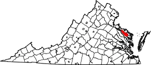 Location within the U.S. state of Virginia | |
 Virginia's location within the U.S. | |
| Coordinates: 37°56′N 76°43′W | |
| Country | |
| State | |
| Founded | 1692 |
| Named for | Richmond, London or Charles Lennox |
| Seat | Warsaw |
| Largest town | Warsaw |
| Area | |
| • Total | 216 sq mi (560 km2) |
| • Land | 191 sq mi (490 km2) |
| • Water | 25 sq mi (60 km2) 11.5% |
| Population (2010) | |
| • Total | 9,254 |
| • Estimate (2018)[1] | 9,038 |
| • Density | 43/sq mi (17/km2) |
| Time zone | UTC−5 (Eastern) |
| • Summer (DST) | UTC−4 (EDT) |
| Congressional district | 1st |
| Website | www |
Geography
According to the U.S. Census Bureau, the county has a total area of 216 square miles (560 km2), of which 191 square miles (490 km2) is land and 25 square miles (65 km2) (11.5%) is water.[4]
Adjacent counties
- Westmoreland County, Virginia – north
- Northumberland County, Virginia – east
- Lancaster County, Virginia – southeast
- Essex County, Virginia – southwest
National protected area
- Rappahannock River Valley National Wildlife Refuge (part) Franklin, Island Farm, Laurel Grove, Peter, Tayloe, Wellford, Wilna, Wright units; Menokin, Wellford easements
Demographics
| Historical population | |||
|---|---|---|---|
| Census | Pop. | %± | |
| 1790 | 6,985 | — | |
| 1800 | 13,744 | 96.8% | |
| 1810 | 6,214 | −54.8% | |
| 1820 | 5,706 | −8.2% | |
| 1830 | 6,055 | 6.1% | |
| 1840 | 5,965 | −1.5% | |
| 1850 | 6,448 | 8.1% | |
| 1860 | 6,856 | 6.3% | |
| 1870 | 6,503 | −5.1% | |
| 1880 | 7,195 | 10.6% | |
| 1890 | 7,146 | −0.7% | |
| 1900 | 7,088 | −0.8% | |
| 1910 | 7,415 | 4.6% | |
| 1920 | 7,434 | 0.3% | |
| 1930 | 6,878 | −7.5% | |
| 1940 | 6,634 | −3.5% | |
| 1950 | 6,189 | −6.7% | |
| 1960 | 6,375 | 3.0% | |
| 1970 | 5,841 | −8.4% | |
| 1980 | 6,952 | 19.0% | |
| 1990 | 7,273 | 4.6% | |
| 2000 | 8,809 | 21.1% | |
| 2010 | 9,254 | 5.1% | |
| 2018 (est.) | 9,038 | [1] | −2.3% |
| U.S. Decennial Census[5] 1790–1960[6] 1900–1990[7] 1990–2000[8] 2010–2013[2] | |||
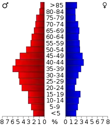
As of the census[9] of 2000, there were 8809 people, 2,937 households, and 2,000 families residing in the county. The population density was 46 people per square mile (18/km2). There were 3,512 housing units at an average density of 18 per square mile (7/km2). The racial makeup of the county was 64.77% White, 33.17% Black or African American, 0.09% Native American, 0.32% Asian, 0.07% Pacific Islander, 0.85% from other races, and 0.73% from two or more races. 2.10% of the population were Hispanic or Latino of any race.
There were 2,937 households, out of which 27.20% had children under the age of 18 living with them, 52.30% were married couples living together, 11.80% had a female householder with no husband present, and 31.90% were non-families. 28.30% of all households were made up of individuals, and 14.20% had someone living alone who was 65 years of age or older. The average household size was 2.40 and the average family size was 2.93.
In the county, the population was spread out, with 18.40% under the age of 18, 8.00% from 18 to 24, 31.80% from 25 to 44, 24.10% from 45 to 64, and 17.70% who were 65 years of age or older. The median age was 40 years. For every 100 females there were 127.60 males. For every 100 females age 18 and over, there were 131.90 males.
The median income for a household in the county was $33,026, and the median income for a family was $42,143. Males had a median income of $30,722 versus $21,807 for females. The per capita income for the county was $16,675. About 11.90% of families and 15.40% of the population were below the poverty line, including 21.20% of those under age 18 and 12.50% of those age 65 or over.
In 2004 the Menokin Bluegrass Festival (later changed to Menokin Music Festival) was launched in Richmond County at the ruins of Francis Lightfoot Lee's (a signer of the Declaration of Independence) ancestral home, Menokin. The festival attracts thousands of music fans every year in a celebration of the Northern Neck's historical legacy.
Communities

Town
Unincorporated communities
Germans Corner another locality name in the county. It is about 1.5 miles north of Naylors Beach, at the junction of Virginia State Route 636 and Virginia State Route 624. It is named from Wilber L. Jerman, who built a large dwelling at the location in 1923, and lived there until 1946. Jerman's wife Cleva May was deeded 50 acres extending from the south and west of the corner from her father in 1920. Over time the original "Jerman's Corner" has come to be misspelled and known as "German's Corner."[10]
Politics
| Year | Republican | Democratic | Third parties |
|---|---|---|---|
| 2020 | 62.1% 2,547 | 36.9% 1,513 | 1.1% 42 |
| 2016 | 60.5% 2,213 | 36.8% 1,347 | 2.8% 101 |
| 2012 | 57.3% 2,160 | 41.8% 1,574 | 1.0% 36 |
| 2008 | 55.9% 2,092 | 43.2% 1,618 | 0.9% 35 |
| 2004 | 62.0% 2,082 | 37.0% 1,243 | 1.1% 36 |
| 2000 | 60.5% 1,784 | 36.5% 1,076 | 3.0% 89 |
| 1996 | 50.9% 1,424 | 39.4% 1,101 | 9.7% 272 |
| 1992 | 52.8% 1,609 | 33.9% 1,034 | 13.3% 407 |
| 1988 | 66.2% 1,862 | 32.9% 924 | 0.9% 25 |
| 1984 | 68.5% 1,869 | 30.4% 830 | 1.1% 31 |
| 1980 | 62.8% 1,567 | 34.2% 854 | 3.0% 74 |
| 1976 | 60.8% 1,391 | 37.8% 864 | 1.4% 33 |
| 1972 | 77.6% 1,565 | 21.6% 435 | 0.9% 18 |
| 1968 | 48.9% 1,011 | 23.7% 490 | 27.5% 568 |
| 1964 | 58.5% 901 | 41.3% 636 | 0.2% 3 |
| 1960 | 65.0% 801 | 34.5% 425 | 0.6% 7 |
| 1956 | 67.9% 761 | 24.4% 274 | 7.7% 86 |
| 1952 | 68.9% 727 | 30.9% 326 | 0.2% 2 |
| 1948 | 48.1% 296 | 39.0% 240 | 12.8% 79 |
| 1944 | 47.9% 336 | 51.9% 364 | 0.1% 1 |
| 1940 | 34.7% 257 | 64.1% 475 | 1.2% 9 |
| 1936 | 32.5% 217 | 67.5% 451 | |
| 1932 | 29.1% 192 | 70.0% 461 | 0.9% 6 |
| 1928 | 61.5% 467 | 38.5% 292 | |
| 1924 | 26.5% 125 | 72.2% 340 | 1.3% 6 |
| 1920 | 39.1% 206 | 60.9% 321 | |
| 1916 | 35.4% 180 | 64.6% 329 | |
| 1912 | 22.4% 110 | 69.5% 342 | 8.1% 40 |
References
- "Population and Housing Unit Estimates". Retrieved July 14, 2019.
- "State & County QuickFacts". United States Census Bureau. Retrieved January 5, 2014.
- "Find a County". National Association of Counties. Archived from the original on May 31, 2011. Retrieved 2011-06-07.
- "US Gazetteer files: 2010, 2000, and 1990". United States Census Bureau. 2011-02-12. Retrieved 2011-04-23.
- "U.S. Decennial Census". United States Census Bureau. Retrieved January 5, 2014.
- "Historical Census Browser". University of Virginia Library. Retrieved January 5, 2014.
- "Population of Counties by Decennial Census: 1900 to 1990". United States Census Bureau. Retrieved January 5, 2014.
- "Census 2000 PHC-T-4. Ranking Tables for Counties: 1990 and 2000" (PDF). United States Census Bureau. Retrieved January 5, 2014.
- "U.S. Census website". United States Census Bureau. Retrieved 2011-05-14.
- Ryland, Elizabeth Lowell. Richmond County, Virginia: A Review Commemorating the Bicentennial, p. 48 )(1976)
- Leip, David. "Dave Leip's Atlas of U.S. Presidential Elections". uselectionatlas.org. Retrieved 2020-12-09.
External links
Places adjacent to Richmond County, Virginia | ||||||||||
|---|---|---|---|---|---|---|---|---|---|---|
| ||||||||||
| Authority control |
|---|