Lark Harbour
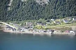
Lark Harbour is small fishing community on the western coast of Newfoundland, on the south side of the Bay of Islands, and west of the City of Corner Brook.
Lark Harbour | |
|---|---|
Town | |
 Lark Harbour (showing promontory in Blow Me Down Provincial Park) | |
 Lark Harbour Location of Lark Harbour in Newfoundland | |
| Coordinates: 49°06′N 58°22′W | |
| Country | |
| Province | |
| Population (2016)[1] | |
| • Total | 522 |
| Time zone | UTC-3:30 (Newfoundland Time) |
| • Summer (DST) | UTC-2:30 (Newfoundland Daylight) |
| Area code(s) | 709 |
| Highways | |
 | |
 Newfoundland and Labrador | |
| |
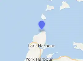
| Location | South Head Lark Harbour Newfoundland Canada |
|---|---|
| Coordinates | 49°08′48.0″N 58°22′13.3″W |
| Year first constructed | 1925 (first) 1950 (second) |
| Year first lit | 2010 (current) |
| Deactivated | 1950 (first) 2010 (second) |
| Foundation | concrete base |
| Construction | wooden tower (first) concrete tower (second) fiberglass tower (current) |
| Tower shape | hexagonal frustum tower with balcony and lantern (second) cylindrical tower with light (current) |
| Markings / pattern | white tower, red lantern (second) white tower with two red narrow horizontal band (current) |
| Tower height | 6.1 metres (20 ft) (first) 10.7 metres (35 ft) (second) |
| Focal height | 35.4 metres (116 ft) (first) 35 metres (115 ft) (current) |
| Current lens | LED lamp |
| Light source | solar power |
| Range | 6 nautical miles (11 km; 6.9 mi) |
| Characteristic | Fl W 4s. |
| Admiralty number | H0186 |
| CHS number | CCG 192 |
| NGA number | 2604 |
| ARLHS number | CAN-751 |
| Managing agent | Canadian Coast Guard[2][3] |
Combined with neighbouring York Harbour, there is a population of about 866. Blow Me Down Provincial Park lies on the boundary between the two communities.
Captain James Cook and the naming of Lark Harbour and York Harbour
Local legend has it that James Cook named the harbours after two of his ships. However, while it is true that Cook spent the years 1764 to 1767 surveying and charting the coasts of Newfoundland and was working in the Bay of Islands in the summer of 1767, he had charge of only one ship, the schooner Grenville. Not a naval vessel, and built and operated in Massachusetts under the name Sally, she had been purchased by the Royal Navy for Cook's use while surveying.
HMS Lark and HMS York, after which the harbours were named, were ships of the Royal Navy's Newfoundland Squadron. To command such ships a naval commission was required, and Cook held no such commission during his years in Newfoundland: he was at that time a sailing master. The title of captain, or commander, was reserved for commissioned officers of the Navy.
Most of the names of natural features, such as Blow-me-down Mountain, Tweed Island, Guernsey Island and Pearl Island, (these last three also named after frigates of the Newfoundland Squadron) had appeared earlier on maps drawn by Joseph Gilbert, who was sailing master aboard HMS Guernsey when the British Governor of Newfoundland, Hugh Palliser, visited the Bay of Islands in 1764. Palliser, newly appointed to his responsibilities as governor, quickly understood that reliable charts of the waters around Newfoundland would be useful tools in the Navy's defence strategy. Cook was already a capable surveyor, and it was Palliser who assigned him to the task in Newfoundland. Cook would undoubtedly have had copies of any existing charts and log notes, including Gilbert's, when he began his work, and would have incorporated into his own work the names he saw on those documents.
See also
References
- "Census Profile, 2016 Census: Lark Harbour, Town [Census subdivision], Newfoundland and Labrador". Statistics Canada. Retrieved October 17, 2019.
- Central and Western Newfoundland The Lighthouse Directory. University of North Carolina at Chapel Hill. Retrieved 16 February 2017
- List of Lights, Pub. 110: Greenland, The East Coasts of North and South America (Excluding Continental U.S.A. Except the East Coast of Florida) and the West Indies (PDF). List of Lights. United States National Geospatial-Intelligence Agency. 2016.
External links
- Aids to Navigation Canadian Coast Guard
| Wikimedia Commons has media related to Lark Harbour. |
Division No. 5, Newfoundland and Labrador (Humber District) | ||
|---|---|---|
| Cities |  | |
| Towns | ||
| Unorganized subdivisions |
| |