List of Category A listed buildings in Clackmannanshire
This is a list of Category A listed buildings in Clackmannanshire, Scotland.
In Scotland, the term listed building refers to a building or other structure officially designated as being of "special architectural or historic interest".[1] Category A structures are those considered to be buildings of "national or international importance, either architecturally or historically".[1] Listing was begun by a provision in the Town and Country Planning (Scotland) Act 1947, and the current legislative basis for listing is the Planning (Listed Buildings and Conservation Areas) (Scotland) Act 1997.[1] The authority for listing rests with Historic Environment Scotland, an executive agency of the Scottish Government, which inherited this role from the Scottish Development Department in 1991. Once listed, severe restrictions are imposed on the modifications allowed to a building's structure or its fittings. Listed building consent must be obtained from local authorities prior to any alteration to such a structure. There are approximately 47,000 listed buildings in Scotland, of which around 8 percent (some 3,800) are Category A.[1]
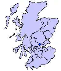
The council area of Clackmannanshire covers 159 square kilometres (61 sq mi), and has a population of around 50,000. Some 300 listed buildings are recorded in the Clackmannanshire Development Plan, of which 18 are Category A.[2] These represent a variety of types and ages of structure. Listed structures range in size from William Henry Playfair's Greek-revival Dollar Academy, to the tiny Johnstone Mausoleum at Alva. Many of the earliest buildings, including the Old Kirk at Tullibody, and several late-medieval castles and tower houses, are now in ruins, although Alloa Tower is still habitable. Later dwellings include the 17th-century Menstrie Castle, 18th-century Brucefield, and 20th-century Gean House. The 19th-century cast iron bridge at Cambus is one of the earliest in Scotland.[3] The textile mills and warehouse of the former Kilncraigs factory represent 20th-century heritage, and were restored in 2004.[4]
Listed buildings
| Name | Location | Date Listed | Grid Ref. [note 1] | Geo-coordinates | Notes | LB Number [note 2] | Image |
|---|---|---|---|---|---|---|---|
| Clackmannan Tolbooth, Mercat Cross and Clackmannan Stone | Clackmannan | 14/2/2017 | NS911918 | 56°06′26″N 3°45′09″W | Belfry tower, market cross and Mannan stone | 1947 | 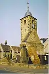
|
| Brucefield House | 4.5 kilometres (2.8 mi) east of Clackmannan | 12/6/1972 | NS956916 | 56°06′22″N 3°40′46″W | 18th-century country house | 1956 | 
|
| Tullibody Old Kirk | Tullibody | 9/6/1960 | NS860954 | 56°08′17″N 3°50′07″W | 12th-century church, rebuilt 16th century and now ruined | 1972 | 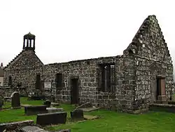
|
| Tullibody Old Bridge over the River Devon | Bridgend, by Tullibody | 9/6/1960 | NS846951 | 56°08′06″N 3°51′28″W | Early 16th-century stone bridge | 1977 | 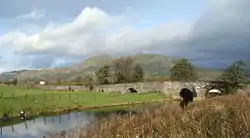
|
| Sauchie Tower (or Devon Tower) | Sauchie | 9/6/1960 | NS897958 | 56°08′33″N 3°46′33″W | Early 15th-century tower house | 1980 | 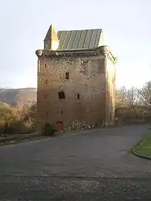
|
| Iron bridge over the River Devon | Cambus, by Tullibody | 12/6/1972 | NS853940 | 56°07′31″N 3°50′45″W | Early 19th-century cast-iron bridge | 1985 | 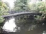
|
| Menstrie Castle | Castle Court, Menstrie | 9/6/1960 | NS849967 | 56°08′58″N 3°51′13″W | 17th-century house | 2025 | 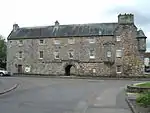
|
| 25 Kirkgate (Star House) | Kirkgate, Alloa | 9/6/1960 | NS886925 | 56°06′46″N 3°47′32″W | Late 17th-century town house | 20955 |
|
| Kilncraigs Mills (formerly Patons and Baldwins) | Greenside Street, Alloa | 12/6/1972 | NS888927 | 56°06′52″N 3°47′21″W | Early 20th-century factory and offices | 20956 | 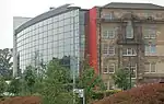
|
| Alloa Tower | Alloa | 9/6/1960 | NS888925 | 56°06′46″N 3°47′20″W | 15th-century tower house with later additions | 20959 | 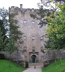
|
| Spiers Centre | Primrose Street and Primrose Place, Alloa | 12/6/1972 | Former public baths and gymnasium. Renamed for the boxer Tommy Spiers. | 21009 |
| ||
| Gean House | Tullibody Road, Alloa | 12/6/1972 | NS874939 | 56°07′30″N 3°48′44″W | Arts and Crafts house of 1911 | 21016 | 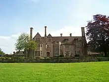
|
| Inglewood House | Tullibody Road, Alloa | 12/6/1972 | NS879941 | 56°07′37″N 3°48′15″W | Jacobean style house of c.1900 | 21019 |
|
| Johnstone Mausoleum | Alva Churchyard, Alva | 12/6/1972 | NS885975 | 56°09′27″N 3°47′45″W | 1790 tomb designed by Robert and James Adam | 21031 |
|
| Dollar Academy | Dollar | 9/6/1960 | NS961982 | 56°09′56″N 3°40′26″W | School built in 1820 by William Henry Playfair | 24546 | 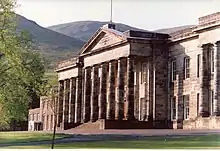
|
| Kilncraigs Despatch Warehouse | Greenside Street, Alloa | 12/6/1972 | NS887925 | 56°06′46″N 3°47′26″W | 1936 warehouse | 49975 | 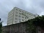
|
Notes
- Sometimes known as OSGB36, the grid reference (where provided) is based on the British national grid reference system used by the Ordnance Survey.
• "Guide to National Grid". Ordnance Survey. Retrieved 2007-12-12.
• "Get-a-map". Ordnance Survey. Retrieved 2007-12-17. - Historic Environment Scotland assign a unique alphanumeric identifier to each designated site in Scotland, for listed buildings this always begins with "LB", for example "LB12345".
References
- Scotland’s Listed Buildings 2016. Historic Environment Scotland. 2016. Retrieved 20 February 2017.
- "Development Plan Appendix - Listed Buildings". Clackmannanshire Development Plan. Clackmannanshire Council. Archived from the original on December 1, 2008. Retrieved 2010-05-05.
- "Iron bridge over River Devon at Cambus, Listed Building Report". Historic Environment Scotland. Retrieved 20 February 2017.
- "Greenside Street, Kilncraigs, Listed Building Report". Historic Environment Scotland. Retrieved 20 February 2017.
External links
![]() Media related to Category A listed buildings in Clackmannanshire at Wikimedia Commons
Media related to Category A listed buildings in Clackmannanshire at Wikimedia Commons