List of Category A listed buildings in South Lanarkshire
This is a list of Category A listed buildings in South Lanarkshire, central Scotland.
In Scotland, the term listed building refers to a building or other structure officially designated as being of "special architectural or historic interest".[1] Category A structures are those considered to be "buildings of national or international importance, either architectural or historic, or fine little-altered examples of some particular period, style or building type."[2] Listing was begun by a provision in the Town and Country Planning (Scotland) Act 1947, and the current legislative basis for listing is the Planning (Listed Buildings and Conservation Areas) (Scotland) Act 1997.[3] The authority for listing rests with Historic Scotland, an executive agency of the Scottish Government, which inherited this role from the Scottish Development Department in 1991. Once listed, severe restrictions are imposed on the modifications allowed to a building's structure or its fittings. Listed building consent must be obtained from local authorities prior to any alteration to such a structure.[3] There are approximately 47,400 listed buildings in Scotland, of which around 8% (some 3,800) are Category A.[4]
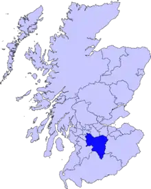
The council area of South Lanarkshire covers 1,772 square kilometres (684 sq mi), and has a population of around 310,100. There are 90 Category A listed buildings in the area.
Listed buildings
| Name | Location | Date Listed | Grid Ref. [note 1] | Geo-coordinates | Notes | LB Number [note 2] | Image |
|---|---|---|---|---|---|---|---|
| Brownsbank Cottage | Candy Mill, Elsrickle | NT0749741856 | 55°39′41″N 3°28′19″W | 19th-century farm cottage, former home of poet Hugh MacDiarmid[5] | 640 | 
| |
| Old Collegiate Church, St. Mary's Aisle, and Graveyard | Carnwath, St Mary's Church | NS9754246411 | 55°42′01″N 3°37′55″W | 15th-century aisle of former church, located adjacent to present parish church[6] | 692 | 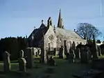
| |
| Carnwath Cross | Carnwath | NS9792346401 | 55°42′01″N 3°37′33″W | 17th-century market cross[7] | 694 | 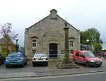
| |
| Carstairs House (Monteith House) | Carstairs | NS9417644333 | 55°40′51″N 3°41′04″W | Tudor Gothic house by William Burn, 1823, later used as a hospital and nursing home[8] | 712 | 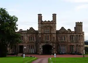
| |
| Tower of Hallbar | Crossford | NS8393047130 | 55°42′13″N 3°50′55″W | 16th-century tower house[9] | 723 | 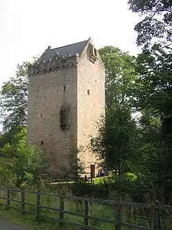
| |
| High Mill | Carluke, Chapel Street | NS8493550778 | 55°44′12″N 3°50′03″W | Late-18th-century windmill tower and 19th-century house, the most complete windmill in Scotland[10] | 726 | 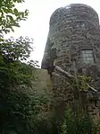
| |
| Scots Mining Company House | Leadhills | NS8861614808 | 55°24′52″N 3°45′40″W | Early classical house built 1736, possibly by William Adam, for the manager of the lead mines[11] | 732 |
| |
| Crossbasket | East Kilbride | NS6666856508 | 55°47′00″N 4°07′40″W | 16th-century tower with 19th-century house[12] | 1004 | 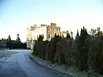
| |
| The Peel | Busby | NS5931356121 | 55°46′40″N 4°14′41″W | 16th-century tower with later additions[13] | 1005 | .jpg.webp)
| |
| The Peel, stable or barn | Busby | NS5936056067 | 55°46′39″N 4°14′38″W | 17th-century stable building[14] | 1006 |
| |
| Wester Kittochside Farm | East Kilbride | NS6083256331 | 55°46′49″N 4°13′14″W | 18th-century farm, gifted to the National Trust for Scotland in 1992, now part of the National Museum of Rural Life[15] | 1008 | 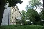
| |
| Earl of Angus' Monument | Douglas | NS8346730955 | 55°33′30″N 3°50′57″W | Monument to James Douglas, Earl of Angus, sculpted by Thomas Brock, erected 1892[16] | 1457 | 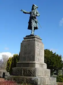
| |
| St Bride's Chapel | Douglas | NS8358730952 | 55°33′30″N 3°50′50″W | Choir and south aisle of late-14th-century Gothic church, restored in 1878 by Robert Rowand Anderson, containing tombs of some of the Earls of Douglas[17] | 1490 | 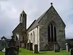
| |
| Newbigging Market Cross | Newbigging | NT0151845916 | 55°41′48″N 3°34′06″W | Market cross dated 1693[18] | 5093 |
| |
| Covington Parish Church | Covington, Thankerton | NS9750639751 | 55°38′26″N 3°37′48″W | 15th-century church, renovated 1903[19] | 5094 | 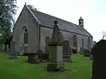
| |
| Bothwell Parish Church (St Bride's Collegiate Church) | Bothwell | NS7049058604 | 55°48′12″N 4°04′04″W | 14th-century choir, extended by David Hamilton, 1833, restored 1898 by Robert Rowand Anderson[20] | 5134 | 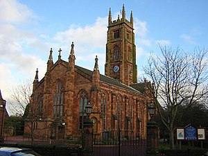
| |
| Bothwell Parish Church, Joanna Baillie Monument | Bothwell | NS7044458591 | 55°48′11″N 4°04′06″W | Italianate Doultonware monument to poet Joanna Baillie[21] | 5135 |
| |
| Bothwell Bridge | Bothwell, over the River Clyde | NS7107757765 | 55°47′45″N 4°03′29″W | Earlier 17th-century four-arch bridge, altered in the 19th century, on site of the Battle of Bothwell Bridge, 1679[22] | 5138 | 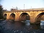
| |
| Criagievar and Gleneden | Bothwell, Laighlands Road | NS7091158497 | 55°48′09″N 4°03′40″W | 1855 villa by Alexander Thomson[23] | 5151 |
| |
| Uddingston Viaduct | Uddingston | NS6879560883 | 55°49′24″N 4°05′45″W | Three-arch cast-iron railway viaduct over River Clyde, 1848[24] | 5153 | 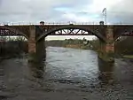
| |
| Scottish National Memorial to David Livingstone | Blantyre, Station Road, David Livingstone Memorial | NS6950858517 | 55°48′08″N 4°05′00″W | 18th-century workers' houses, now the David Livingstone Centre[25] | 5162 | 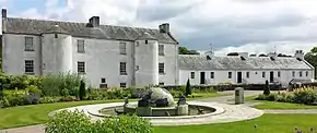
| |
| Dalserf Parish Church | Dalserf | NS7997950712 | 55°44′06″N 3°54′47″W | 17th- and 18th-century T-plan church with later alterations[26] | 5170 | 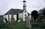
| |
| Mauldslie Bridge | Dalserf | NS8036050245 | 55°43′51″N 3°54′24″W | Three-arch stone bridge over the River Clyde by David Bryce, 1861, as private access to Mauldslie Castle (demolished)[27] | 5175 | 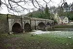
| |
| Canderside Bridge | Canderside, Stonehouse | NS7654747435 | 55°42′17″N 3°57′58″W | Three-arch stone bridge over Cander Water, by Thomas Telford, 1821[28] | 6452 | 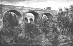
| |
| Corehouse | Falls of Clyde | NS8822741580 | 55°39′17″N 3°46′41″W | Tudor Revival country house by Edward Blore, 1824–1827[29] | 7679 | 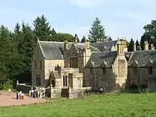
| |
| Corra Castle | Falls of Clyde | 12/01/1971 | NS8822941410 | 55°39′12″N 3°46′40″W | Ruined tower[30] | 7680 | 
|
| Chatelherault Hunting Lodge and Leopard House | Chatelherault Country Park, Hamilton | NS7364453930 | 55°45′44″N 4°00′55″W | Ornamental hunting lodge by William Adam, 1731, associated with Hamilton Palace [31] | 12485 | 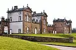
| |
| Avon Bridge | Hamilton, Carlisle Road | NS7351054768 | 55°46′11″N 4°01′04″W | Single-span bridge by Thomas Telford, 1820, carrying the A72 road over the Avon Water[32] | 12516 | .jpg.webp)
| |
| Old Avon Bridge | Hamilton, Old Avon Road | NS7332254637 | 55°46′06″N 4°01′15″W | 17th-century three-arch bridge over the Avon Water[33] | 12518 | 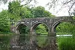
| |
| Hamilton Monument | Hamilton | NS7289854385 | 55°45′58″N 4°01′39″W | Bust of William Hamilton, 11th Duke of Hamilton by T. Mossmann, dated 1869[34] | 12520 | 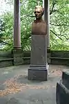
| |
| Barncluith House, terraces and summerhouse | Hamilton | NS7299554480 | 55°46′01″N 4°01′33″W | 16th-century garden terraces[35] | 12522 | _(14760846574).jpg.webp)
| |
| Baronald (Cartland Bridge Hotel) | Lanark | NS8734844615 | 55°40′55″N 3°47′35″W | Large Scots Baronial mansion by Sir John James Burnet, 1891[36] | 12967 | 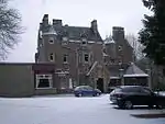
| |
| Jerviswood | Lanark | NS8837645514 | 55°41′25″N 3°46′38″W | 17th-century house[37] | 13053 |
| |
| Hyndford Bridge | Lanark | NS9147941460 | 55°39′16″N 3°43′35″W | Five-arch bridge of 1773, carrying the A73 road over the River Clyde[38] | 13055 | 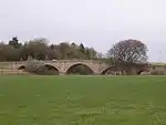
| |
| Corra Linn, Bonnington Pavilion | Falls of Clyde | NS8848641473 | 55°39′14″N 3°46′26″W | 18th-century classical viewing pavilion[39] | 13065 | 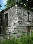
| |
| Symington House | Symington | NT0097335192 | 55°36′01″N 3°34′23″W | Neo-Georgian mansion of 1915 by Andrew Prentice[40] | 19673 | .jpg.webp)
| |
| Gas Showrooms | Biggar, Gasworks Road | NT0389137707 | 55°37′24″N 3°31′40″W | Showrooms of circa 1840[41] | 22170 | 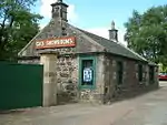
| |
| Gaswork Manager's House | Biggar, Gasworks Road | NT0391337699 | 55°37′24″N 3°31′39″W | House of circa 1840[42] | 22171 |
| |
| Biggar Gasworks | Biggar | NT0388037687 | 55°37′24″N 3°31′41″W | Important early gaswork with many original features, 1839 onwards[43] | 22172 | 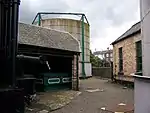
| |
| Cadger's Brig | Biggar | NT0387537615 | 55°37′21″N 3°31′41″W | 18th-century single-arch bridge[44] | 22173 | 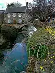
| |
| St Mary's Church | Biggar | NS0404737895 | 55°37′30″N 3°31′31″W | 16th-century church [45] | 22257 | 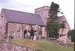
| |
| The Hunter Museum (formerly Hunter House) | East Kilbride, Maxwelton Road | NS6522255804 | 55°46′36″N 4°09′01″W | 18th-century house, converted to museum 1996[46] | 26607 | 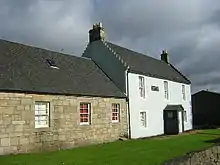
| |
| Brousterlands | East Kilbride, Brousterhill | NS6345154407 | 55°45′49″N 4°10′40″W | Late-17th-century classical laird's house[47] | 26619 | 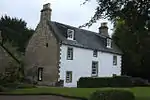
| |
| Mains Castle | East Kilbride | NS6278856041 | 55°46′41″N 4°11′21″W | Mid 15th-century tower house, restored in the 1970s[48] | 26626 | 
| |
| St Bride's Roman Catholic Church | East Kilbride | NS6404754304 | 55°45′47″N 4°10′06″W | 1964 church by Gillespie, Kidd and Coia[49] | 26630 | 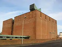
| |
| Rutherglen Tower and fragments of Old Church | Rutherglen | NS6133161705 | 55°49′43″N 4°12′55″W | Late medieval with later rebuilding[50] | 33563 | 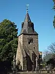
| |
| Rutherglen Town Hall | Rutherglen | NS6137561700 | 55°49′43″N 4°12′53″W | Scots baronial town hall by Charles Wilson, 1862[51] | 33564 | 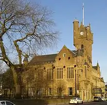
| |
| St Columbkille's Roman Catholic Church | Rutherglen | NS6142261590 | 55°49′39″N 4°12′50″W | Church by Gillespie, Kidd and Coia, 1934–40[52] | 33567 | 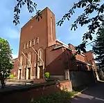
| |
| Sheriff Court Buildings | Hamilton, Almada Street | NS7160055907 | 55°46′46″N 4°02′56″W | Mid 19th-century classical buildings[53] | 34470 | 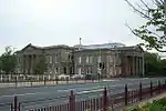
| |
| Lanark County Buildings (South Lanarkshire Council Headquarters) | Hamilton, Almada Street | NS7147155882 | 55°46′45″N 4°03′03″W | International modern tower by D G Bannerman, 1959–64[54] | 34472 | 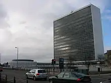
| |
| Hamilton Old Parish Church | Hamilton | NS7232755534 | 55°46′34″N 4°02′13″W | Church by William Adam, 1732[55] | 34473 | 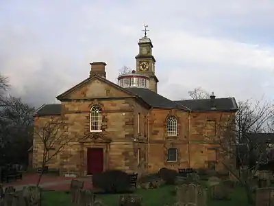
| |
| Hamilton Old Parish Church, churchyard | Hamilton | NS7234255555 | 55°46′35″N 4°02′12″W | 17th- and 18th-century monuments, and medieval Netherton Cross[56] | 34474 | 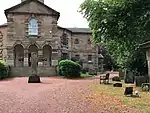
| |
| 92-94 Cadzow Street | Hamilton | NS7233255638 | 55°46′38″N 4°02′13″W | Large commercial building built along with Cadzow bridge, by Babtie & Bonn, structural engineers, 1903[57] | 34503 | 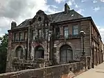
| |
| Cadzow Bridge, Cadzow Street | Hamilton | NS7230055630 | 55°46′37″N 4°02′15″W | 19th-century bridge widened in 1903 by Babtie & Bonn[58] | 34504 | 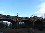
| |
| Hamilton Mausoleum | Hamilton | NS7269056316 | 55°47′00″N 4°01′54″W | Roman style mausoleum of Alexander, 10th Duke of Hamilton, built 1855 by David Bryce[59] | 34518 | 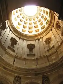
| |
| Hamilton Burgh Museum | Hamilton, Muir Street | NS7244355899 | 55°46′46″N 4°02′07″W | 18th-century house by James Smith and later assembly rooms, now part of the Low Parks Museum[60] | 34521 | 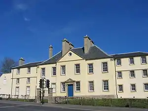
| |
| Riding School | Hamilton, Muir Street | Not listed | NS7245455923 | 55°46′47″N 4°02′07″W | 19th-century building, now part of the Low Parks Museum[61] | 34522 |
|
| Gates, gatepiers and railings at Auction Room and Cattle Market | Lanark, Hyndford Road | NS8890043200 | 55°40′10″N 3°46′05″W | Pair of wrought- and cast-iron former toll gates, circa 1820 [62] | 37024 |
| |
| Cemetery Chapel | Lanark, Hyndford Road | 7/5/1980 | NS8887543193 | 55°40′10″N 3°46′06″W | [63] | 37029 | 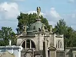
|
| Clydesholm Bridge | Lanark, Mousemill Road | NS8687243918 | 55°40′32″N 3°48′02″W | 3-span bridge built by John Lockhart of Birkenhead, 1696–99, the oldest surviving crossing of the River Clyde[64] | 37032 | 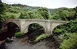
| |
| New Lanark, Community Hall (former church) | New Lanark | NS8801442650 | 55°39′52″N 3°46′54″W | Simple Gothic church by Thomas Carlaw, 1899[65] | 37037 | 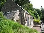
| |
| New Lanark, 1-10 (inclusive) Braxfield Row | New Lanark | NS8788742713 | 55°39′54″N 3°47′02″W | Gabled terrace of mill workers' houses, circa 1790 [66] | 37038 |
| |
| New Lanark, 1-8 (inclusive) Caithness Row and the Counting House | New Lanark | NS8813042492 | 55°39′47″N 3°46′48″W | Gabled terrace of mill workers' houses, circa 1790, with Counting House of 1816, restored 1966 [67] | 37039 | 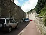
| |
| New Lanark, 9-16 (inclusive) Caithness Row with garages (former abattoir) | New Lanark | NS8815842445 | 55°39′45″N 3°46′46″W | Gabled terrace of mill workers' houses, circa 1790, restored 1966[68] | 37040 |
| |
| New Lanark, 1-8 (inclusive) Double Row, known as Wee Row | New Lanark | NS8796242626 | 55°39′51″N 3°46′57″W | Late-18th-century terrace of mill workers' houses, restored 1994[69] | 37041 | 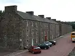
| |
| New Lanark, 9-24 (inclusive) Double Row | New Lanark | NS8791142650 | 55°39′52″N 3°47′00″W | Late-18th-century gabled terrace of mill workers' houses[70] | 37042 | 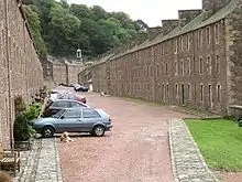
| |
| New Lanark, 1-14 (inclusive) Long Row | New Lanark | NS8793542661 | 55°39′52″N 3°46′59″W | Late-18th-century terrace of mill workers' houses, the longest terrace at New Lanark[71] | 37043 |
| |
| New Lanark, New Buildings | New Lanark | NS8809342562 | 55°39′49″N 3°46′50″W | Classical Palazzo-style gabled terrace of mill workers' tenements, 1798, restored from 1978[72] | 37045 | 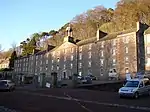
| |
| New Lanark, 1-11 (inclusive) Nursery Buildings | New Lanark | NS8810442552 | 55°39′49″N 3°46′49″W | Terrace of mill workers' tenements with village bakery, 1809 with 1850 additions[73] | 37046 | .jpg.webp)
| |
| New Lanark, 1 and 3 Rosedale Street, Robert Owen's House | New Lanark | NS8802542594 | 55°39′50″N 3°46′54″W | Gabled house of circa 1790[74] | 37047 | 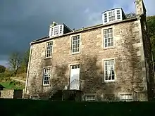
| |
| New Lanark, 5 and 7 Rosedale Street, David Dale's House | New Lanark | NS8799242611 | 55°39′51″N 3°46′56″W | Gabled house of circa 1790[75] | 37048 | 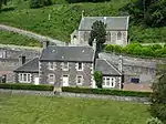
| |
| New Lanark, Visitor Centre (formerly New Institution For The Formation Of Character and Engine House) | New Lanark | NS8807742504 | 55°39′47″N 3°46′51″W | Classical former Institution of 1816, engine house added to north in 1881[76] | 37049 | 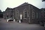
| |
| New Lanark, Education Centre (formerly the School) | New Lanark | NS8810442432 | 55°39′45″N 3°46′49″W | Symmetrical classical former school, 1817[77] | 37050 | 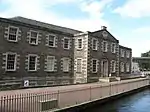
| |
| New Lanark, Mill No 1 | New Lanark | NS8795042556 | 55°39′49″N 3°46′58″W | 5-storey mill, built 1786, rebuilt after fire 1789, restored as a hotel in the 1990s[78] | 37051 | 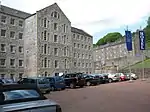
| |
| New Lanark, Mill No 2 | New Lanark | NS8798242532 | 55°39′48″N 3°46′56″W | 5-storey textile mill, built circa 1789 and linked to Mill No 1 by 1817, extended north in 1885[79] | 37052 | 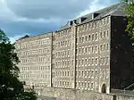
| |
| New Lanark, Mill No 3 with Turbine House | New Lanark | NS8800942516 | 55°39′48″N 3°46′55″W | 6-storey classical textile mill, built 1833, the best-preserved of the New Lanark mills[80] | 37053 |
| |
| New Lanark, Mechanics' Workshop | New Lanark | NS8811542353 | 55°39′42″N 3°46′48″W | 2-storey classical block of 1806[81] | 37054 | 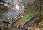
| |
| New Lanark, Scottish Wildlife Trust Visitor Centre (formerly dyeworks and foundry) | New Lanark | NS8809642347 | 55°39′42″N 3°46′49″W | Former foundry, 1806[82] | 37055 | 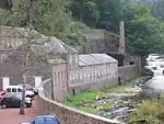
| |
| New Lanark, Retort House Chimney | New Lanark | NS8809042282 | 55°39′40″N 3°46′50″W | Octagonal sandstone chimney of earlier 19th-century gas-making plant[83] | 37056 | 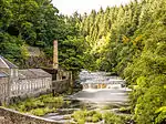
| |
| St Mary's Roman Catholic Church | Lanark, St Vincent Place | NS8857043510 | 55°40′20″N 3°46′24″W | Mid 19th-century Gothic revival church by Goldie and Hadfield, rebuilt 1908 after fire[84] | 37062 | .jpg.webp)
| |
| St Mary's Church Hall | Lanark, St Vincent Place | NS8856043549 | 55°40′21″N 3°46′25″W | Mid 19th-century school by Goldie and Hadfield[85] | 37065 |
| |
| St Mary's Presbytery | Lanark, St Vincent Place | NS8859943511 | 55°40′20″N 3°46′22″W | Mid 19th-century L-plan building by Goldie and Hadfield[86] | 37066 |
| |
| New Lanark, Weir, Tunnel and Lade | New Lanark | NS8811642077 | 55°39′33″N 3°46′48″W | Stone and timber weir and rock-cut tunnel, built 1785[87] | 44552 | 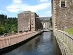
| |
| Mauldslie West Lodge, gateway and gates | Mauldslie, Dalserf | NS8032850238 | 55°43′51″N 3°54′26″W | Gothic lodge, probably David Bryce, dated 1861[88] | 45125 | 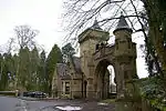
| |
| New Lanark, Water Houses | New Lanark | NS8793842530 | 55°39′48″N 3°46′59″W | Terrace of former stores, built 1810 and converted to residential use in the 1990s[89] | 46471 |
| |
| Torrance House | Calderglen Country Park, East Kilbride | NS6547852651 | 55°44′55″N 4°08′41″W | Early-17th-century L-plan tower house, with 18th-century additions to designs by William Adam, and 19th-century Scots Baronial alterations[90] | 48654 | 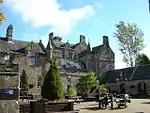
| |
| Dollan Aqua Centre | East Kilbride | 13 June 2002 | NS6316054220 | 55°45′43″N 4°10′57″W | Swimming pool by Buchanan Campbell, 1965, with parabolic roof[91] | 48682 | 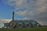
|
| Stonebyres Power Station | Falls of Clyde | 11/02/2011 | NS8502044158 | 55°40′38″N 3°49′43″W | Hydro-electric plant [92] | 51719 | 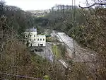
|
| Stonebyres Power Station wier and bridge | Falls of Clyde | 11/02/2011 | NS8550744025 | 55°40′34″N 3°49′20″W | [93] | 51720 | 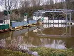
|
| Bonnington Power Station | Falls of Clyde | 3/3/2011 | NS8839841665 | 55°39′20″N 3°46′31″W | Hydro-electric plant[94] | 51727 | 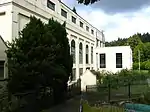
|
| Bonnington Power Station wier and bridge | Falls of Clyde | 3/3/2011 | NS8550744025 | 55°40′34″N 3°49′20″W | [95] | 51728 | 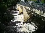
|
Notes
- Sometimes known as OSGB36, the grid reference (where provided) is based on the British national grid reference system used by the Ordnance Survey.
• "Guide to National Grid". Ordnance Survey. Retrieved 2007-12-12.
• "Get-a-map". Ordnance Survey. Retrieved 2007-12-17. - Historic Environment Scotland assign a unique alphanumeric identifier to each designated site in Scotland, for listed buildings this always begins with "LB", for example "LB12345".
References
- Guide to the Protection of Scotland’s Listed Buildings (PDF). Historic Scotland. 2009. p. 4. ISBN 978-1-84917-013-0. Retrieved 2010-05-05.
- "What is Listing?". Historic Scotland. Retrieved 2010-05-05.
- Scottish Historic Environment Policy (PDF). Historic Scotland. October 2008. pp. 24–25. ISBN 978-1-84917-002-4. Retrieved 2010-05-05.
- Guide to the Protection of Scotland’s Listed Buildings, p. 17.
- "Brownsbank Cottage: Listed Building Report". Historic Scotland.
- "Old Collegiate Church, St. Mary's Aisle, And Graveyard: Listed Building Report". Historic Scotland.
- "Carnwath Cross: Listed Building Report". Historic Scotland.
- "Carstairs House: Listed Building Report". Historic Scotland.
- "Tower Of Hallbar: Listed Building Report". Historic Scotland.
- "High Mill Chapel Street: Listed Building Report". Historic Scotland.
- "Leadhills Village Scots Mining Company House And Garden Walls: Listed Building Report". Historic Scotland.
- "Crossbasket: Listed Building Report". Historic Scotland.
- "The Peel: Listed Building Report". Historic Scotland.
- "The Peel, Stable Or Barn: Listed Building Report". Historic Scotland.
- "Wester Kittochside, Including Farmhouse, Steading, Dutch Barns, Boundary Walls And Gatepiers: Listed Building Report". Historic Scotland.
- "Douglas Village Earl Of Angus' Monument: Listed Building Report". Historic Scotland.
- "Douglas Village St Bride's Chapel & Churchyard Walls: Listed Building Report". Historic Scotland.
- "Newbigging, Market Cross: Listed Building Report". Historic Scotland.
- "Parish Church And Graveyard: Listed Building Report". Historic Scotland.
- "Bothwell, Main Street, St Bride's Collegiate Church, (Church Of Scotland), Including Graveyard, Boundary Walls, Gatepiers And Gates: Listed Building Report". Historic Scotland.
- "Bothwell, Bothwell Parish Church, Joanna Baillie Monument: Listed Building Report". Historic Scotland.
- "Bothwell, Bothwell Bridge: Listed Building Report". Historic Scotland.
- "Bothwell, Laighlands Road, Criagievar And Gleneden Including Entrance Lampstands: Listed Building Report". Historic Scotland.
- "Uddingston, Uddingston Viaduct: Listed Building Report". Historic Scotland.
- "Scottish National Memorial To David Livingstone: Listed Building Report". Historic Scotland.
- "Dalserf Village, Dalserf Parish Church, Church Of Scotland, Including Walled Churchyard, Gatepiers And Gates: Listed Building Report". Historic Scotland.
- "Mauldslie Bridge, River Clyde: Listed Building Report". Historic Scotland.
- "Canderside Bridge, Cander Water: Listed Building Report". Historic Scotland.
- "Corehouse: Listed Building Report". Historic Scotland.
- "Corra Castle: Listed Building Report". Historic Scotland.
- "Chatelherault Hunting Lodge, Ornamental Gardens Boundary And Courtyard Walls And Leopard House: Listed Building Report". Historic Scotland.
- "Avon Bridge: Listed Building Report". Historic Scotland.
- "Old Avon Bridge: Listed Building Report". Historic Scotland.
- "Hamilton Monument: Listed Building Report". Historic Scotland.
- "Terraces And Summerhouse, Barncluith: Listed Building Report". Historic Scotland.
- "Baronald (Cartland Bridge Hotel): Listed Building Report". Historic Scotland.
- "Jerviswood: Listed Building Report". Historic Scotland.
- "Hyndford Bridge: Listed Building Report". Historic Scotland.
- "Corra Linn, Pavilion: Listed Building Report". Historic Scotland.
- "Symington House: Listed Building Report". Historic Scotland.
- "Gas Showrooms, Gasworks Road.: Listed Building Report". Historic Scotland.
- "2, Gasworks Road.: Listed Building Report". Historic Scotland.
- "Biggar Gasworks: Listed Building Report". Historic Scotland.
- "Cadger's Brig High Street: Listed Building Report". Historic Scotland.
- "St Mary's Church Kirkstyle: Listed Building Report". Historic Scotland.
- "Maxwelton Road, The Hunter Museum (Formerly Hunter House), Including Gatepiers And Boundary Wall: Listed Building Report". Historic Scotland.
- "Brousterhill, Brousterlands: Listed Building Report". Historic Scotland.
- "Mains Road, Mains Castle: Listed Building Report". Historic Scotland.
- "Whitemoss Avenue, St Bride's Roman Catholic Church, Including Presbytery And Ancillary Buildings: Listed Building Report". Historic Scotland.
- "Main Street, Rutherglen Tower And Fragments Of Old Church: Listed Building Report". Historic Scotland.
- "131, 139 Main Street, Rutherglen, District Council Offices (Originally Town Hall): Listed Building Report". Historic Scotland.
- "152, 154 Main Street, Rutherglen, Kirkwood Street, St Columbkillie's Rc Church And Presbytery: Listed Building Report". Historic Scotland.
- "Sheriff Court Buildings, Almada Street: Listed Building Report". Historic Scotland.
- "Almada Street, Lanark County Buildings: Listed Building Report". Historic Scotland.
- "Parish Church Ann Street: Listed Building Report". Historic Scotland.
- "Churchyard Ann Street: Listed Building Report". Historic Scotland.
- "Cadzow Street, 92, 94: Listed Building Report". Historic Scotland.
- "Cadzow Bridge Cadzow Street: Listed Building Report". Historic Scotland.
- "Hamilton Mausoleum: Listed Building Report". Historic Scotland.
- "Hamilton Burgh Museum Muir Street: Listed Building Report". Historic Scotland.
- "Riding School Off Muir Street: Listed Building Report". Historic Scotland.
- "Hyndford Road, Gates, Gatepiers And Railings At Auction Room And Cattle Market: Listed Building Report". Historic Scotland.
- "CEMETERY CHAPEL, HYNDFORD ROADLB37029". Historic Environment Scotland. Retrieved 25 August 2017.
- "Mousemill Road, Clydesholm Bridge: Listed Building Report". Historic Scotland.
- "New Lanark, Church Of Scotland With Gatepiers, Railings And Boundary Walls: Listed Building Report". Historic Scotland.
- "New Lanark 1-10 (Inclusive Nos) Braxfield Row: Listed Building Report". Historic Scotland.
- "New Lanark, 1-8 (Inclusive Nos) Caithness Row And The Counting House: Listed Building Report". Historic Scotland.
- "New Lanark, 9-16 (Inclusive Nos) Caithness Row With Garages (Former Abattoir): Listed Building Report". Historic Scotland.
- "New Lanark, 1-8 (Inclusive Nos) Double Row, Known As Wee Row: Listed Building Report". Historic Scotland.
- "New Lanark, 9-24 (Inclusive Nos) Double Row: Listed Building Report". Historic Scotland.
- "New Lanark, 1-14 (Inclusive Nos) Long Row: Listed Building Report". Historic Scotland.
- "New Lanark, New Buildings: Listed Building Report". Historic Scotland.
- "New Lanark, 1-11 (Inclusive Nos) Nursery Buildings: Listed Building Report". Historic Scotland.
- "New Lanark, 1 And 3 Rosedale Street, Robert Owen's House: Listed Building Report". Historic Scotland.
- "New Lanark, 5 And 7 Rosedale Street, David Dale's House: Listed Building Report". Historic Scotland.
- "New Lanark, Institute For The Formation Of Character And Engine House: Listed Building Report". Historic Scotland.
- "New Lanark, The School: Listed Building Report". Historic Scotland.
- "New Lanark, Mill No 1: Listed Building Report". Historic Scotland.
- "New Lanark, Mill No 2: Listed Building Report". Historic Scotland.
- "New Lanark, Mill No 3 With Turbine House: Listed Building Report". Historic Scotland.
- "New Lanark, Mechanics' Workshop: Listed Building Report". Historic Scotland.
- "New Lanark, Dyeworks: Listed Building Report". Historic Scotland.
- "New Lanark, Retort House Chimney: Listed Building Report". Historic Scotland.
- "St Mary's Rc Church, St Vincent Place: Listed Building Report". Historic Scotland.
- "St Mary's Church Hall, St Vincent Place: Listed Building Report". Historic Scotland.
- "St Mary's Presbytery St Vincent Place: Listed Building Report". Historic Scotland.
- "New Lanark, Weir, Tunnel And Lade: Listed Building Report". Historic Scotland.
- "Mauldslie West Lodge, Gateway And Gates: Listed Building Report". Historic Scotland.
- "New Lanark, Water Houses: Listed Building Report". Historic Scotland.
- "Calderglen Country Park, (Formerly Torrance House Estate), Torrance House And Courtyard: Listed Building Report". Historic Scotland.
- "Town Centre Park, Dollan Aqua Centre: Listed Building Report". Historic Scotland.
- "FALLS OF CLYDE, STONEBYRES POWER STATION WITH TANK AND PIPESLB51719". Historic Environment Scotland. Retrieved 25 August 2017.
- "FALLS OF CLYDE, STONEBYRES POWER STATION WEIR AND BRIDGELB51720". Historic Environment Scotland. Retrieved 25 August 2017.
- "FALLS OF CLYDE, BONNINGTON POWER STATION WITH TANK AND PIPESLB51727". Historic Environment Scotland. Retrieved 25 August 2017.
- "FALLS OF CLYDE, BONNINGTON POWER STATION WEIR AND BRIDGELB51728". Historic Environment Scotland. Retrieved 25 August 2017.
External links
![]() Media related to Category A listed buildings in South Lanarkshire at Wikimedia Commons
Media related to Category A listed buildings in South Lanarkshire at Wikimedia Commons
- Category A Listed Buildings in South Lanarkshire at British Listed Buildings