List of Category A listed buildings in Dundee
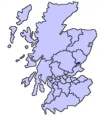
This is a list of Category A listed buildings in the Dundee council area in eastern Scotland.
In Scotland, the term listed building refers to a building or other structure officially designated as being of "special architectural or historic interest".[1] Category A structures are those considered to be "buildings of national or international importance, either architectural or historic, or fine little-altered examples of some particular period, style or building type".[2] Listing was begun by a provision in the Town and Country Planning (Scotland) Act 1947, and the current legislative basis for listing is the Planning (Listed Buildings and Conservation Areas) (Scotland) Act 1997.[3] The authority for listing rests with Historic Environment Scotland. In 2015 it succeeded Historic Scotland, an executive agency of the Scottish Government, which had inherited this role from the Scottish Development Department in 1991. Once listed, severe restrictions are imposed on the modifications allowed to a building's structure or its fittings. Listed building consent must be obtained from local authorities prior to any alteration to such a structure.[3] There are approximately 47,400 listed buildings in Scotland, of which around 8% (some 3,800) are Category A.[4]
The council area of Dundee covers 67 square kilometres (26 sq mi), and has a population of around 152,320. There are 83 Category A listed buildings in the area.
Listed buildings
| Name | Location | Date Listed | Grid Ref. [note 1] | Geo-coordinates | Notes | LB Number [note 2] | Image |
|---|---|---|---|---|---|---|---|
| Benvie Mill | Benvie | NO3280931493 | 56°28′15″N 3°05′32″W | [5] | 10864 | 
| |
| Gray House, also known as House of Gray | Mains of Gray | NO3377432099 | 56°28′35″N 3°04′36″W | [6] | 12858 | .jpg.webp)
| |
| Old Powrie Castle | Fintry | Delisted | NO4214134572 | 56°29′59″N 2°56′29″W | [7] | 19018 |
|
| Powrie Castle | Fintry | NO4212734592 | 56°29′59″N 2°56′30″W | [8] | 19019 |
| |
| Camperdown Dock | Dundee Harbour | NO4132230540 | 56°27′48″N 2°57′14″W | [9] | 24923 | 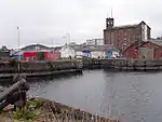
| |
| Harbour, or Clocktower, Warehouse | Dundee Harbour, Victoria Dock | NO4111330533 | 56°27′48″N 2°57′26″W | [10] | 24932 | .jpg.webp)
| |
| McManus Galleries | Dundee, Albert Square | NO4027930475 | 56°27′45″N 2°58′15″W | [11] | 24939 | 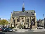
| |
| The Coffin Mill, Logie Works | Dundee, Brook Street | NO3917230402 | 56°27′43″N 2°59′19″W | [12] | 24956 |
| |
| Harbour Workshops and Patent Slip | Dundee, Marine Parade | NO4090630162 | 56°27′36″N 2°57′38″W | [13] | 24957 |
| |
| Old Tay Works Mills, Engine Houses and Chimney | Dundee, Brown Street | NO3974130379 | 56°27′42″N 2°58′46″W | [14] | 24960 | .jpg.webp)
| |
| South Mills | Dundee, Brown Street | NO3972030255 | 56°27′38″N 2°58′47″W | [15] | 24965 |
| |
| Victoria Dock with pedestrian and vehicular swing bridges | Dundee Harbour | NO4095830366 | 56°27′42″N 2°57′35″W | [16] | 24971 |
| |
| Dundee Royal Infirmary, original block Out Patients Dept & Urology Theatre | Dundee, Barrack Road | NO3966730773 | 56°27′55″N 2°58′51″W | [17] | 24982 |
| |
| Baxter Park Pavilion | Dundee, Baxter Park | NO4152331521 | 56°28′20″N 2°57′03″W | [18] | 24992 | 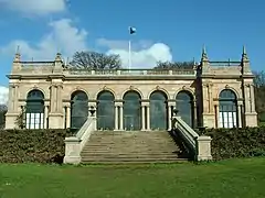
| |
| Castle Hill House | Dundee, Castlehill | NO4045230310 | 56°27′40″N 2°58′04″W | [19] | 24993 |
| |
| St Paul's Episcopal Cathedral | Dundee, Castlehill | NO4044930284 | 56°27′39″N 2°58′05″W | [20] | 24997 | .jpg.webp)
| |
| Former Edward Street Mill | Dundee, Edward Street | NO3907830357 | 56°27′41″N 2°59′25″W | [21] | 25003 |
| |
| Tay Works | Dundee, Lochee Road | NO3976830432 | 56°27′44″N 2°58′45″W | [22] | 25030 |
| |
| Camperdown Works, High Mill or Sliver Mill | Dundee, Methven Street | NO3807231610 | 56°28′21″N 3°00′25″W | [23] | 25041 |
| |
| Camperdown Works, Cox's Stack | Dundee, Methven Street | NO3828231636 | 56°28′22″N 3°00′12″W | [24] | 25044 | 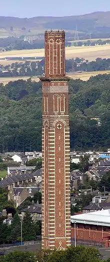
| |
| Mains Castle | Dundee, Caird Park | NO4109233018 | 56°29′08″N 2°57′29″W | [25] | 25066 | 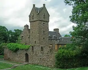
| |
| 51-63 (odd nos) Commercial Street | Dundee, Commercial Street | NO4042430378 | 56°27′42″N 2°58′06″W | [26] | 25071 |
| |
| 73-99 (odd nos) Commercial Street, Commercial Bank | Dundee, Commercial Street | NO4036730418 | 56°27′44″N 2°58′10″W | [27] | 25075 |
| |
| Camperdown House | Camperdown | NO3588332974 | 56°29′04″N 3°02′34″W | [28] | 25078 | 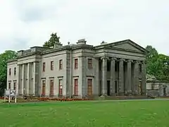
| |
| Lower Dens Works | Dundee, Princes Street | NO4075130782 | 56°27′56″N 2°57′47″W | [29] | 25093 | .jpg.webp)
| |
| 68-110 (even nos) Commercial Street (Northern Assurance Buildings) | Dundee, Commercial Street | NO4029330429 | 56°27′44″N 2°58′14″W | [30] | 25099 | .jpg.webp)
| |
| Upper Dens Mill | Dundee, Princes Street | NO4077730847 | 56°27′58″N 2°57′46″W | [31] | 25101 |
| |
| Seafield Works (west side of Taylor's lane only) | Dundee, Taylor's Lane | NO3883029618 | 56°27′17″N 2°59′39″W | [32] | 25111 |
| |
| Claverhouse Bleachfield, former Beetling House, Office and Chimney Stalk | Dundee, Claverhouse Road | NO4082533726 | 56°29′31″N 2°57′46″W | [33] | 25112 |
| |
| Verdant Works | Dundee, West Henderson's Wynd | NO3952930369 | 56°27′42″N 2°58′58″W | [34] | 25140 | .jpg.webp)
| |
| Former Exchange Coffee House | Dundee, Dock Street | NO4048430198 | 56°27′37″N 2°58′03″W | [35] | 25150 | .jpg.webp)
| |
| High School of Dundee | Dundee, Euclid Crescent | NO4013330512 | 56°27′47″N 2°58′23″W | [36] | 25177 | 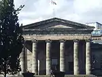
| |
| High School, (Former Girls' School) | Dundee, Euclid Crescent | NO4006530455 | 56°27′45″N 2°58′27″W | [37] | 25189 |
| |
| Watson's Bond, HM Customs Warehouse No 4 | Dundee, Seagate | NO4052930507 | 56°27′47″N 2°58′00″W | [38] | 25194 |
| |
| Dudhope Castle | Dundee, Barrack Road | NO3945930670 | 56°27′51″N 2°59′03″W | [39] | 25195 | 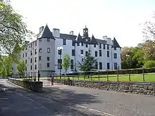
| |
| Wishart Arch | Dundee, East (Cowgate) Port | Delisted | NO4068830725 | 56°27′54″N 2°57′51″W | [40] | 25209 | 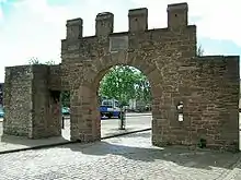
|
| Former Dundee Foundry (stonebuilt, cast-iron framed engine shop only) | Dundee, East Dock Street | NO4086730602 | 56°27′50″N 2°57′40″W | [41] | 25236 |
| |
| 70-73 (inclusive nos) High Street, including Gardyne's Land, Gray's Close, including clock and model of the town house | Dundee, High Street | NO4033530292 | 56°27′40″N 2°58′11″W | [42] | 25239 | .jpg.webp)
| |
| 74, 75 and 76 High Street | Dundee, High Street | NO4034730302 | 56°27′40″N 2°58′11″W | [43] | 25243 |
| |
| 77–80 (inclusive nos) High Street and returns to Murraygate/Commercial Street (Arnott's) | Dundee, High Street | NO4035830370 | 56°27′42″N 2°58′10″W | [44] | 25247 |
| |
| Caird Hall | Dundee, City Square | NO4031030159 | 56°27′35″N 2°58′13″W | [45] | 25258 | 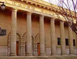
| |
| St Andrew's Church (Church of Scotland) | Dundee, King Street | NO4045330694 | 56°27′53″N 2°58′05″W | [46] | 25279 | 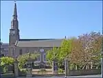
| |
| Clepington Primary School (former Stobswell Public School) | Dundee, Eliza Street | NO4099231596 | 56°28′22″N 2°57′34″W | [47] | 25280 | 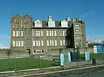
| |
| Morgan Academy | Dundee, Forfar Road | NO4132531790 | 56°28′28″N 2°57′15″W | [48] | 25288 | 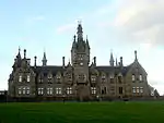
| |
| The Howff | Dundee, Barrack Street | NO4015230357 | 56°27′42″N 2°58′22″W | [49] | 25312 | 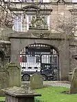
| |
| St Salvador's Episcopal Church | Dundee, St Salvador Street | NO4025731310 | 56°28′12″N 2°58′17″W | [50] | 25314 | .jpg.webp)
| |
| St Mary's RC Church | Lochee, High Street | NO3800931403 | 56°28′14″N 3°00′28″W | [51] | 25338 |
| |
| Invergowrie House | Dundee, Invergowrie Drive | NO3618930392 | 56°27′41″N 3°02′14″W | [52] | 25369 |
| |
| City Churches, St Mary's Tower, or The Steeple | Dundee, Nethergate | NO4012830121 | 56°27′34″N 2°58′23″W | [53] | 25370 | 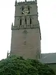
| |
| City Churches, St Clement's, or Steeple Church | Dundee, Nethergate | NO4013630121 | 56°27′34″N 2°58′23″W | [54] | 25374 | -geograph-2679678.jpg.webp)
| |
| City Churches, Old St Paul's and St David's, or South Church | Dundee, Nethergate | NO4016630128 | 56°27′34″N 2°58′21″W | [55] | 25378 |
| |
| City Churches, St Mary's East, or Dundee Parish Church | Dundee, Nethergate | NO4018630136 | 56°27′34″N 2°58′20″W | [56] | 25382 | -geograph-2679665.jpg.webp)
| |
| Morgan Tower | Dundee, Nethergate | NO3993829889 | 56°27′26″N 2°58′34″W | [57] | 25402 | .jpg.webp)
| |
| 136–148 (even nos) Nethergate, including remains of former sea wall to south (Miln's Buildings) | Dundee, Nethergate | NO4005829954 | 56°27′28″N 2°58′27″W | [58] | 25451 |
| |
| Nethergate House (Clydesdale Bank) | Dundee, Nethergate | NO3999029880 | 56°27′26″N 2°58′31″W | [59] | 25458 |
| |
| The Vine | Dundee, Magdalen Yard Road | NO3926129454 | 56°27′12″N 2°59′13″W | [60] | 25469 |
| |
| Coldside Branch Public Library | Dundee, Strathmartine Road | NO3968231843 | 56°28′29″N 2°58′51″W | [61] | 25494 | 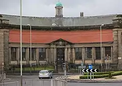
| |
| Magdalen Green Bandstand | Dundee, Magdalen Green | NO3878729434 | 56°27′11″N 2°59′41″W | [62] | 25499 | 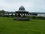
| |
| Royal Exchange | Dundee, Panmure Street | NO4028430544 | 56°27′48″N 2°58′15″W | [63] | 25507 | .jpg.webp)
| |
| India Buildings | Dundee, Victoria Road | NO4020930605 | 56°27′50″N 2°58′19″W | [64] | 25515 |
| |
| Seymour Lodge | Dundee, Perth Road | NO3849329870 | 56°27′25″N 2°59′59″W | [65] | 25542 | 
| |
| 1-27 (odd nos) South Tay Street | Dundee, South Tay Street | NO3995629995 | 56°27′30″N 2°58′33″W | [66] | 25546 |
| |
| St Mark's Church (Gate Fellowship) | Dundee, Perth Road | NO3936529763 | 56°27′22″N 2°59′08″W | [67] | 25601 | 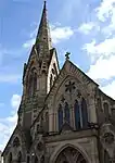
| |
| McCheyne Memorial Church | Dundee, Perth Road | NO3873729776 | 56°27′22″N 2°59′44″W | [68] | 25603 | 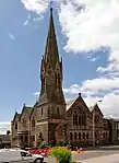
| |
| Greywalls | Dundee, Perth Road | NO3814529714 | 56°27′20″N 3°00′19″W | [69] | 25617 |
| |
| Former Custom House and Harbour Chambers | Dundee, Dock Street | NO4068030319 | 56°27′41″N 2°57′51″W | [70] | 25673 | .jpg.webp)
| |
| 1-32 Springfield (inclusive nos) | Dundee, Springfield | NO3933129797 | 56°27′23″N 2°59′10″W | [71] | 25678 |
| |
| Tay Railway Bridge | Dundee | NO3914327850 | 56°26′20″N 2°59′19″W | [72] | 25681 | 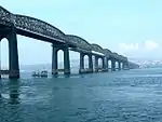
| |
| Balmossie Railway Viaduct over Dichty Water | Balmossie | NO4817532479 | 56°28′54″N 2°50′35″W | [73] | 25739 |
| |
| Broughty Ferry railway station | Broughty Ferry | NO4629330930 | 56°28′03″N 2°52′24″W | [74] | 25823 | 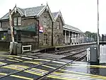
| |
| St Luke's and Queen Street Church | Broughty Ferry, West Queen Street | NO4568131163 | 56°28′10″N 2°53′00″W | [75] | 25885 | 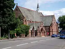
| |
| Eastern Primary School | Broughty Ferry | NO4659930995 | 56°28′05″N 2°52′06″W | [76] | 25887 | 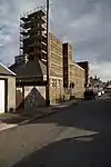
| |
| East Bridge over Dichty Water | Linlathen | NO4639432855 | 56°29′05″N 2°52′19″W | [77] | 25892 | .jpg.webp)
| |
| West Bridge over Dichty Water | Linlathen | NO4603932702 | 56°29′00″N 2°52′40″W | [78] | 25893 |
| |
| Pitkerro Lodge | Pitkerro | NO4530833429 | 56°29′23″N 2°53′23″W | [79] | 25894 |
| |
| Pitkerro House | Pitkerro | NO4532533719 | 56°29′33″N 2°53′22″W | [80] | 25895 |
| |
| St Stephen's and West Church | Broughty Ferry, Dundee Road | NO4576831002 | 56°28′05″N 2°52′55″W | [81] | 25932 | .jpg.webp)
| |
| Red Court | Broughty Ferry, Fairfield Road | NO4461031451 | 56°28′19″N 2°54′02″W | [82] | 25938 |
| |
| Beachtower | Broughty Ferry, Ralston Road | NO4426031175 | 56°28′10″N 2°54′23″W | [83] | 25947 |
| |
| Aystree | Broughty Ferry, Victoria Road | NO4549431375 | 56°28′17″N 2°53′11″W | [84] | 25950 |
|
See also
Notes
- Sometimes known as OSGB36, the grid reference (where provided) is based on the British national grid reference system used by the Ordnance Survey.
• "Guide to National Grid". Ordnance Survey. Retrieved 12 December 2007.
• "Get-a-map". Ordnance Survey. Retrieved 17 December 2007. - Historic Environment Scotland assign a unique alphanumeric identifier to each designated site in Scotland, for listed buildings this always begins with "LB", for example "LB12345".
References
- Guide to the Protection of Scotland's Listed Buildings (PDF). Historic Scotland. 2009. p. 4. ISBN 978-1-84917-013-0. Retrieved 5 May 2010.
- "What is Listing?: Categories of listed building". Historic Environment Scotland. Retrieved 25 March 2019.
- Scottish Historic Environment Policy (PDF). Historic Scotland. October 2008. pp. 24–25. ISBN 978-1-84917-002-4. Retrieved 5 May 2010.
- Guide to the Protection of Scotland’s Listed Buildings, p. 17.
- Historic Environment Scotland. "Benvie Benvie Mill Including House (Category A Listed Building) (LB10864)". Retrieved 26 March 2019.
- Historic Environment Scotland. "Gray House Also Known As House Of Gray (Category A Listed Building) (LB12858)". Retrieved 26 March 2019.
- Historic Environment Scotland. "Powrie, Old Powrie Castle, Including Adjoining Boundary Wall (LB19018)". Retrieved 26 March 2019.
- Historic Environment Scotland. "Powrie, Powrie Castle (Category A Listed Building) (LB19019)". Retrieved 26 March 2019.
- Historic Environment Scotland. "Camperdown Dock (Category A Listed Building) (LB24923)". Retrieved 26 March 2019.
- Historic Environment Scotland. "Camperdown Street And Victoria Dock, Harbour, Or Clocktower, Warehouse (Category A Listed Building) (LB24932)". Retrieved 26 March 2019.
- Historic Environment Scotland. "Albert Square, Mcmanus Galleries, Formerly Albert Institute, Including Lampstandards (Category A Listed Building) (LB24939)". Retrieved 26 March 2019.
- Historic Environment Scotland. "205 Brook Street, Lower Pleasance And Brewery Lane, The Coffin Mill, Logie Works (Category A Listed Building) (LB24956)". Retrieved 26 March 2019.
- Historic Environment Scotland. "Marine Parade, Harbour Workshops And Patent Slip (Category A Listed Building) (LB24957)". Retrieved 26 March 2019.
- Historic Environment Scotland. "25 Brown Street, Old Tay Works Mills, Engine Houses And Chimney (Category A Listed Building) (LB24960)". Retrieved 26 March 2019.
- Historic Environment Scotland. "20 Brown Street, And Return Elevations To 8 Guthrie Street, And Session Street, South Mills (Category A Listed Building) (LB24965)". Retrieved 26 March 2019.
- Historic Environment Scotland. "Victoria Dock With Pedestrian And Vehicular Swing Bridges (Category A Listed Building) (LB24971)". Retrieved 26 March 2019.
- Historic Environment Scotland. "Barrack Rd Dundee Royal Infirmary Original Block Out Patients Dept & Urology Theatre (Category A Listed Building) (LB24982)". Retrieved 26 March 2019.
- Historic Environment Scotland. "Baxter Park Pavilion, Steps, Boundary Walls And Gatepiers (Category A Listed Building) (LB24992)". Retrieved 26 March 2019.
- Historic Environment Scotland. "Castle Hill, South West Corner Of Commercial Street And High Street, Castle Hill House, Including Boundary Wall (Category A Listed Building) (LB24993)". Retrieved 26 March 2019.
- Historic Environment Scotland. "Castle Hill, St Paul's Episcopal Cathedral, Including Steps And Boundary Wall (Category A Listed Building) (LB24997)". Retrieved 26 March 2019.
- Historic Environment Scotland. "Edward Street, Former Edward Street Mill (Category A Listed Building) (LB25003)". Retrieved 26 March 2019.
- Historic Environment Scotland. "2 Lochee Road, Tay Works (Category A Listed Building) (LB25030)". Retrieved 26 March 2019.
- Historic Environment Scotland. "Methven Street, Camperdown Works High Mill Or Sliver Mill (Category A Listed Building) (LB25041)". Retrieved 26 March 2019.
- Historic Environment Scotland. "Methven Street, Camperdown Works, Cox's Stack (Category A Listed Building) (LB25044)". Retrieved 26 March 2019.
- Historic Environment Scotland. "Caird Park Mains Castle (Category A Listed Building) (LB25066)". Retrieved 26 March 2019.
- Historic Environment Scotland. "51-65 (Odd Nos) Commercial Street/1, 3, 5 Murraygate/20-26 (Even Nos) Seagate (Category A Listed Building) (LB25071)". Retrieved 26 March 2019.
- Historic Environment Scotland. "73-99 (Odd Nos) Commercial Street/15, 17 Meadowside/2-10 (Even Nos) Murraygate (Category A Listed Building) (LB25075)". Retrieved 26 March 2019.
- Historic Environment Scotland. "Camperdown House, Camperdown Country Park (Category A Listed Building) (LB25078)". Retrieved 26 March 2019.
- Historic Environment Scotland. "Princes Street And Return Elevations To Dens Street, Constable Street And St Roques Lane, Lower Dens Works (Category A Listed Building) (LB25093)". Retrieved 26 March 2019.
- Historic Environment Scotland. "68-110 (Even Nos) Commercial Street/11, 13 Meadowside (Category A Listed Building) (LB25099)". Retrieved 26 March 2019.
- Historic Environment Scotland. "2 Princes Street, Upper Dens Mill (Category A Listed Building) (LB25101)". Retrieved 26 March 2019.
- Historic Environment Scotland. "Taylor's Lane, Seafield Works (West Side Of Taylor's Lane Only) (Category A Listed Building) (LB25111)". Retrieved 26 March 2019.
- Historic Environment Scotland. "23-45 (Odd Nos) And 14-22 (Even Nos) Heron Rise, Claverhouse Road, Claverhouse Bleachfield, Former Beetling House, Office And Chimney Stalk (TVJ Ltd) (Category A Listed Building) (LB25112)". Retrieved 26 March 2019.
- Historic Environment Scotland. "27 West Henderson's Wynd And Return Elevation To Milne Street, Verdant Works (Category A Listed Building) (LB25140)". Retrieved 26 March 2019.
- Historic Environment Scotland. "16-19 (Inclusive Nos) Dock Street/3-9 (Odd Nos) Exchange Street/15 Shore Terrace, Former Exchange Coffee House (Category A Listed Building) (LB25150)". Retrieved 26 March 2019.
- Historic Environment Scotland. "Euclid Crescent High School, Including Lodge, Gatepiers, Boundary Wall And Railings (Category A Listed Building) (LB25177)". Retrieved 26 March 2019.
- Historic Environment Scotland. "24 Euclid Crescent, High School, (Former Girls' School) (Category A Listed Building) (LB25189)". Retrieved 26 March 2019.
- Historic Environment Scotland. "2, 4 Candle Lane And 99 Seagate And 25-37 (Odd Nos) Trades Lane, Watson's Bond, Hm Customs Warehouse No 4 (Excluding 1 And 2-Storey Building) (Category A Listed Building) (LB25194)". Retrieved 26 March 2019.
- Historic Environment Scotland. "Dudhope Castle (Category A Listed Building) (LB25195)". Retrieved 26 March 2019.
- "Cowgate, Cowgait Port Or Wishart Arch: Listed Building Report". Historic Scotland. Archived from the original on 19 July 2012. Retrieved 3 November 2011.
- Historic Environment Scotland. "42 East Dock Street, Retail Park, Unit 7, Former Dundee Foundry Engine Shop (Category A Listed Building) (LB25236)". Retrieved 26 March 2019.
- Historic Environment Scotland. "70-73 (Inclusive Nos) High Street, Including Gardyne's Land, Gray's Close And Clock With Model Of The Town House (Category A Listed Building) (LB25239)". Retrieved 26 March 2019.
- Historic Environment Scotland. "74, 75 And 76 High Street (Category A Listed Building) (LB25243)". Retrieved 26 March 2019.
- Historic Environment Scotland. "77-80 (Inclusive Nos) High Street And Returns To Murraygate/Commercial Street (Category A Listed Building) (LB25247)". Retrieved 26 March 2019.
- Historic Environment Scotland. "11-13 (Inclusive Nos) City Square, 20-24 (Even Nos) Crichton Street, 1-7 (Inclusive Nos) Shore Terrace And Return To 35 Castle Street, Caird Hall (Category A Listed Building) (LB25258)". Retrieved 26 March 2019.
- Historic Environment Scotland. "2 King Street, St Andrews Church, Including Graveyard, Gate-Piers, Railings And Gates. (Church Of Scotland) (Category A Listed Building) (LB25279)". Retrieved 26 March 2019.
- Historic Environment Scotland. "Eliza Street, Clepington Primary School Former Stobswell Public School, Including Railings And Boundary Walls (Category A Listed Building) (LB25280)". Retrieved 26 March 2019.
- Historic Environment Scotland. "Forfar Road, Morgan Academy, Main Block And Janitor's House, With Terrace, Boundary Walls And Gatepiers (Category A Listed Building) (LB25288)". Retrieved 26 March 2019.
- Historic Environment Scotland. "Meadowside And Barrack Street, The Howff (Category A Listed Building) (LB25312)". Retrieved 26 March 2019.
- Historic Environment Scotland. "St Salvador Street And Church Street, St Salvador's Episcopal Church And Hall (Category A Listed Building) (LB25314)". Retrieved 26 March 2019.
- Historic Environment Scotland. "41 High Street Lochee St Mary's RC Church And Presbytery (Category A Listed Building) (LB25338)". Retrieved 26 March 2019.
- Historic Environment Scotland. "Invergowrie Drive Invergowrie House (Category A Listed Building) (LB25369)". Retrieved 26 March 2019.
- Historic Environment Scotland. "Nethergate, City Churches, St Mary's Tower, Or The Steeple (Category A Listed Building) (LB25370)". Retrieved 26 March 2019.
- Historic Environment Scotland. "Nethergate, City Churches, St Clement's, Or Steeple Church (Category A Listed Building) (LB25374)". Retrieved 26 March 2019.
- Historic Environment Scotland. "Nethergate, City Churches, Old St Paul's And St David's, Or South Church (Category A Listed Building) (LB25378)". Retrieved 26 March 2019.
- Historic Environment Scotland. "Nethergate, City Churches, St Mary's East, Or Dundee Parish Church (Category A Listed Building) (LB25382)". Retrieved 26 March 2019.
- Historic Environment Scotland. "133-139 (Odd Nos) Nethergate, Morgan Tower (Category A Listed Building) (LB25402)". Retrieved 26 March 2019.
- Historic Environment Scotland. "136-148 (Even Nos), Nethergate, Including Remains Of Former Sea Wall To South (Category A Listed Building) (LB25451)". Retrieved 26 March 2019.
- Historic Environment Scotland. "158 Nethergate, Nethergate House, Including Boundary Walls And Railings (Category A Listed Building) (LB25458)". Retrieved 26 March 2019.
- Historic Environment Scotland. "43 Magdalen Yard Road, "The Vine", Including Garden Walls And Gatepiers (Category A Listed Building) (LB25469)". Retrieved 26 March 2019.
- Historic Environment Scotland. "150 Strathmartine Road, Coldside Branch Public Library, Including Railings (Category A Listed Building) (LB25494)". Retrieved 26 March 2019.
- Historic Environment Scotland. "Magdalen Yard Road, Magdalen Green Bandstand (Category A Listed Building) (LB25499)". Retrieved 26 March 2019.
- Historic Environment Scotland. "Panmure Street, Royal Exchange Lane, Royal Exchange (Category A Listed Building) (LB25507)". Retrieved 26 March 2019.
- Historic Environment Scotland. "2, 4 Victoria Road, And 86 Bell Street, India Buildings (Category A Listed Building) (LB25515)". Retrieved 26 March 2019.
- Historic Environment Scotland. "259 Perth Road And Seymour Street, Seymour Lodge, Including Wall And Railings To Seymour Street, Excluding Additions At Rear (Category A Listed Building) (LB25542)". Retrieved 26 March 2019.
- Historic Environment Scotland. "1-27 (Odd Nos) South Tay Street, 105-113, (Odd Nos) Nethergate, Including Railings, And Boundary Walls To Rear (Category A Listed Building) (LB25546)". Retrieved 26 March 2019.
- Historic Environment Scotland. "158 Perth Road, St Mark's Church (Gate Fellowship) (Category A Listed Building) (LB25601)". Retrieved 26 March 2019.
- Historic Environment Scotland. "328 Perth Road, Mccheyne Memorial Church (Category A Listed Building) (LB25603)". Retrieved 26 March 2019.
- Historic Environment Scotland. "452 Perth Road, Greywalls (Category A Listed Building) (LB25617)". Retrieved 26 March 2019.
- Historic Environment Scotland. "Dock Street, Former Custom House And Harbour Chambers (Category A Listed Building) (LB25673)". Retrieved 26 March 2019.
- Historic Environment Scotland. "Springfield 1-32 (Inclusive Nos) (Category A Listed Building) (LB25678)". Retrieved 26 March 2019.
- Historic Environment Scotland. "Tay Railway Bridge (Category A Listed Building) (LB25681)". Retrieved 26 March 2019.
- Historic Environment Scotland. "Balmossie, Balmossie Railway Viaduct Over Dichty Water (Category A Listed Building) (LB25739)". Retrieved 26 March 2019.
- Historic Environment Scotland. "Broughty Ferry, Gray Street, Railway Station Including Subway (Category A Listed Building) (LB25823)". Retrieved 26 March 2019.
- Historic Environment Scotland. "Broughty Ferry, West Queen Street, St Luke's And Queen Street Church (Category A Listed Building) (LB25885)". Retrieved 26 March 2019.
- Historic Environment Scotland. "Broughty Ferry, 2 Whinnybrae, Eastern Primary School, Including Wall And Entrance Gates, And Playsheds And_Lavatories At Rear (Category A Listed Building) (LB25887)". Retrieved 26 March 2019.
- Historic Environment Scotland. "Linlathen, East Bridge Over Dichty Water (Category A Listed Building) (LB25892)". Retrieved 26 March 2019.
- Historic Environment Scotland. "Linlathen, West Bridge Over Dichty Water (Category A Listed Building) (LB25893)". Retrieved 26 March 2019.
- Historic Environment Scotland. "Pitkerro Lodge, Pitkerro Lodge, Including Gatepiers And Gates (Category A Listed Building) (LB25894)". Retrieved 26 March 2019.
- Historic Environment Scotland. "Pitkerro, Pitkerro House, Including Garden Walls And Ruined Dovecot (Category A Listed Building) (LB25895)". Retrieved 26 March 2019.
- Historic Environment Scotland. "West Ferry, 96 Dundee Road, St Stephen's And West Church, Including Enclosing Wall, Gatepiers And Dies (Category A Listed Building) (LB25932)". Retrieved 26 March 2019.
- Historic Environment Scotland. "West Ferry, 17 Fairfield Road, Red Court Including Sundial, Lamp Standard, Gatepiers, Boundary And Garden Walls (Category A Listed Building) (LB25938)". Retrieved 26 March 2019.
- Historic Environment Scotland. "West Ferry, 6 Ralston Road, 1-6 (Inclusive Nos) Beachtower, Including Gatepiers And Boundary Walls (Category A Listed Building) (LB25947)". Retrieved 26 March 2019.
- Historic Environment Scotland. "West Ferry, 26 Victoria Road, Aystree, Including Conservatory, Wall And Gatepiers (Category A Listed Building) (LB25950)". Retrieved 26 March 2019.
External links
![]() Media related to Category A listed buildings in Dundee at Wikimedia Commons
Media related to Category A listed buildings in Dundee at Wikimedia Commons