List of Category A listed buildings in Midlothian
This is a list of Category A listed buildings in Midlothian, Scotland.
In Scotland, the term listed building refers to a building or other structure officially designated as being of "special architectural or historic interest".[1] Category A structures are those considered to be "buildings of national or international importance, either architectural or historic, or fine little-altered examples of some particular period, style or building type."[2] Listing was begun by a provision in the Town and Country Planning (Scotland) Act 1947, and the current legislative basis for listing is the Planning (Listed Buildings and Conservation Areas) (Scotland) Act 1997.[3] The authority for listing rests with Historic Scotland, an executive agency of the Scottish Government, which inherited this role from the Scottish Development Department in 1991. Once listed, severe restrictions are imposed on the modifications allowed to a building's structure or its fittings. Listed building consent must be obtained from local authorities prior to any alteration to such a structure.[3] There are approximately 47,400 listed buildings in Scotland, of which around 8% (some 3,800) are Category A.[4]
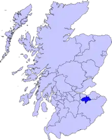
The council area of Midlothian covers 354 square kilometres (137 sq mi), and has a population of around 80,600. There are 71 Category A listed buildings in the area.
Listed buildings
| Name | Location | Date Listed | Grid Ref. [note 1] | Geo-coordinates | Notes | LB Number [note 2] | Image |
|---|---|---|---|---|---|---|---|
| Preston Hall Stables | Preston Hall Policies, Pathhead | NT3962865930 | 55°52′58″N 2°58′00″W | Late-18th-century stable block including kennels, piggery, pheasantry and cottages[5] | 113 | 
| |
| Whitehill House | Rosewell | NT2964062010 | 55°50′46″N 3°07′31″W | 19th-century country house by William Burn, later St Joseph's Institution[6] | 687 |
| |
| Preston Hall, North Gate | Preston Hall Policies, Pathhead | NT4027767156 | 55°53′38″N 2°57′24″W | 18th-century estate gateway[7] | 745 |
| |
| Preston Hall, The Lion's Gate | Preston Hall Policies, Pathhead | NT3925265209 | 55°52′34″N 2°58′21″W | Late-18th-century gates and lodges[8] | 746 | 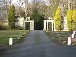
| |
| Crichton Parish Church | Crichton | NT3808261614 | 55°50′37″N 2°59′25″W | 15th-century former collegiate church of S.S. Mary and Kentigern, including graveyard[9] | 753 | 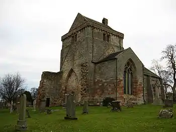
| |
| Ford House | Ford, Pathhead | NT3893564359 | 55°52′07″N 2°58′39″W | 17th-century laird's house[10] | 756 | 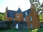
| |
| Crichton House | Crichton | NT4003562476 | 55°51′06″N 2°57′34″W | 17th-century laird's house[11] | 757 |
| |
| Oxenfoord Castle | Pathhead | NT3881665507 | 55°52′44″N 2°58′46″W | 18th-century country house by Robert Adam[12] | 768 | 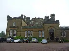
| |
| Oxenfoord Viaduct | Pathhead | NT3882265580 | 55°52′46″N 2°58′46″W | 18th-century bridge accessing Oxenfoord Castle[13] | 769 | .jpg.webp)
| |
| Preston Hall | Pathhead | NT3943165760 | 55°52′52″N 2°58′11″W | Late-18th-century country house by Robert Mitchell[14] | 775 |
| |
| Preston Hall, Walled Garden | Preston Hall Policies, Pathhead | NT3924265952 | 55°52′58″N 2°58′22″W | Walled garden including sheds, gazebos, glass houses, sundial and gardener's house[15] | 777 |
| |
| Preston Hall, The Temple | Preston Hall Policies, Pathhead | NT3950366419 | 55°53′14″N 2°58′07″W | Classical temple folly[16] | 779 | .jpg.webp)
| |
| Cockpen and Carrington Parish Church | Bonnyrigg | NT3193364195 | 55°51′58″N 3°05′21″W | 19th-century church by Archibald Elliot[17] | 780 | 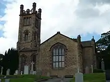
| |
| Dalhousie Castle | Bonnyrigg | NT3234563595 | 55°51′39″N 3°04′57″W | 15th-century castle, extended in the 19th century by William Burn[18] | 784 | 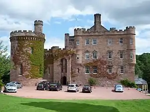
| |
| Vogrie House | Newlandrig, Pathhead | NT3808663236 | 55°51′30″N 2°59′26″W | 19th-century country house[19] | 799 | 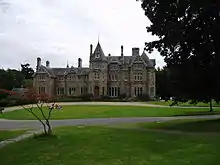
| |
| Borthwick Castle | Borthwick | NT3699059732 | 55°49′36″N 3°00′26″W | 15th-century tower house[20] | 805 | 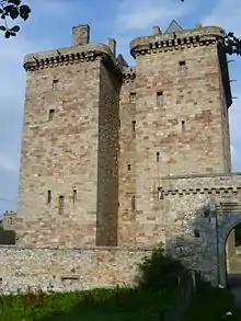
| |
| Middleton Hall | North Middleton | NT3680558261 | 55°48′48″N 3°00′36″W | Early-18th-century country house[21] | 806 |
| |
| Arniston House | Temple | NT3258959467 | 55°49′25″N 3°04′39″W | [22] | 808 | 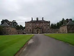
| |
| Arniston House, Grotto | Temple | NT3239959186 | 55°49′16″N 3°04′50″W | 18th-century country house by William Adam[23] | 811 |
| |
| Arniston House, North Gate-Lodge and Elephant Gates | Temple | NT3366761215 | 55°50′22″N 3°03′39″W | 18th-century gates and lodges[24] | 814 |
| |
| Dalkeith House, Conservatory | Dalkeith | NT3381868175 | 55°54′08″N 3°03′36″W | 19th-century conservatory by William Burn[25] | 1410 | 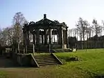
| |
| Dalkeith House | Dalkeith | NT3332567905 | 55°53′59″N 3°04′04″W | Early-18th-century country house by James Smith[26] | 1411 | 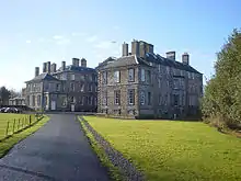
| |
| Dalkeith House, Dark Walk Gateway | Dalkeith | NT3384067660 | 55°53′51″N 3°03′34″W | 18th-century gateway[27] | 1412 | 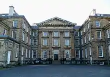
| |
| Dalkeith House, King's Gate | Dalkeith | NT3219267700 | 55°53′51″N 3°05′09″W | 19th-century gateway and lodge by David Bryce and William Burn[28] | 1437 | 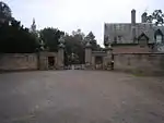
| |
| Dalkeith House, Montagu Bridge | Dalkeith | NT3336368120 | 55°54′06″N 3°04′02″W | 18th-century bridge by Robert Adam[29] | 1440 | 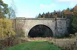
| |
| St Mary's Episcopal Church, Dalkeith | Musselburgh Road, Dalkeith | NT3348967727 | 55°53′53″N 3°03′55″W | 19th-century Gothic church by David Bryce and William Burn[30] | 1441 | 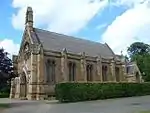
| |
| Dalkeith House, Stables and Coach House | Dalkeith | NT3377968134 | 55°54′06″N 3°03′38″W | 18th-century stable block by William Adam[31] | 1442 |
| |
| Glenesk Railway Viaduct | Eskbank | NT3237267136 | 55°53′33″N 3°04′58″W | 19th-century bridge carrying the Edinburgh and Dalkeith Railway over the River North Esk[32] | 1445 |
| |
| Lothian Bridge | Pathhead | NT3910064527 | 55°52′12″N 2°58′29″W | 19th-century bridge by Thomas Telford, carrying the A68 road over the Tyne Water[33] | 5090 | 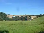
| |
| Mavisbank House, Dovecot | Loanhead | NT2939265742 | 55°52′47″N 3°07′49″W | 18th-century circular doocot[34] | 7386 | .jpg.webp)
| |
| Mavisbank House, Gazebo | Loanhead | NT2886864916 | 55°52′20″N 3°08′18″W | 18th-century garden building[35] | 7387 |
| |
| Melville Castle | Lasswade | NT3103066981 | 55°53′28″N 3°06′16″W | 18th-century Gothic house by James Playfair[36] | 7394 | 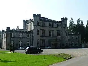
| |
| Barony House | Wadingburn Road, Lasswade | NT2970065910 | 55°52′52″N 3°07′31″W | Late-18th-century cottage, remodelled by John Clerk of Eldin[37] | 7398 |
| |
| Mavisbank House | Loanhead | NT2880765146 | 55°52′27″N 3°08′22″W | 18th-century country house by William Adam and Sir John Clerk of Penicuik[38] | 7404 | 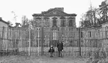
| |
| Glencorse Old Parish Church | Glencorse, Penicuik | NT2451863038 | 55°51′17″N 3°12′26″W | 17th-century church, now roofless[39] | 7454 | .jpg.webp)
| |
| Glencorse Parish Church | Glencorse, Penicuik | NT2466762616 | 55°51′03″N 3°12′17″W | 19th-century church by Robert Rowand Anderson[40] | 7456 | 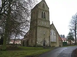
| |
| Bush House | Bush, Penicuik | NT2457863534 | 55°51′33″N 3°12′23″W | 18th-century house by the Adam Brothers[41] | 7462 | 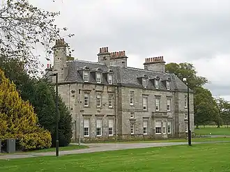
| |
| Melville Castle, Willie's Temple | Lasswade | NT3053966850 | 55°53′23″N 3°06′44″W | 18th-century folly[42] | 12940 |
| |
| Hawthornden Castle | Rosewell, Midlothian | NT2862063677 | 55°51′39″N 3°08′31″W | Castle, largely of the 17th century, partly restored[43] | 13023 | 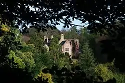
| |
| Roslin Castle | Roslin | NT2747562763 | 55°51′09″N 3°09′36″W | Ruined 15th-century defences, with 17th-century house[44] | 13026 | 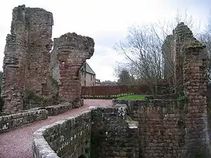
| |
| Rosslyn Chapel | Roslin | NT2748963073 | 55°51′19″N 3°09′36″W | 15th-century collegiate chapel[45] | 13028 | 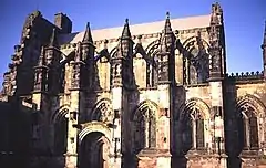
| |
| Auchendinny House | Auchendinny | NT2517261336 | 55°50′22″N 3°11′47″W | Early-18th-century house by Sir William Bruce[46] | 13034 |
| |
| Bilston Viaduct | Loanhead | NT2807364861 | 55°52′17″N 3°09′04″W | 19th-century viaduct for the Edinburgh, Loanhead and Roslin Railway, over the Bilston Burn[47] | 13035 | 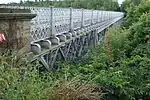
| |
| Woolmet House, Gateway | Danderhall | NT3071569917 | 55°55′02″N 3°06′36″W | 17th-century gateway of demolished Woolmet House, now part of Danderhall Miners' Club[48] | 14184 | .jpg.webp)
| |
| Newbattle Abbey | Newbattle | NT3334966021 | 55°52′58″N 3°04′01″W | 16th-century house, later extended, on site of a 12th-century Cistercian monastery[49] | 14561 | 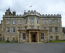
| |
| Newbattle Abbey, North Sundial | Newbattle | NT3340366084 | 55°53′00″N 3°03′58″W | 17th-century sundial, one of a pair with the South Sundial[50] | 14562 | .jpg.webp)
| |
| Newbattle Abbey, South Sundial | Newbattle | NT3343566019 | 55°52′58″N 3°03′56″W | 17th-century sundial, one of a pair with the North Sundial[51] | 14563 | .jpg.webp)
| |
| Newbattle Abbey, Maiden Bridge | Newbattle | NT3367366590 | 55°53′16″N 3°03′43″W | 15th-century bridge over the River South Esk[52] | 14564 | .jpg.webp)
| |
| Newbattle Abbey, Monkland Wall | Newbattle | NT3311465839 | 55°52′52″N 3°04′15″W | Medieval boundary wall[53] | 14566 | 
| |
| Newbattle Abbey, Port Gate-Lodges and Gates | Newbattle | NT3311565881 | 55°52′53″N 3°04′15″W | Early-18th-century gateway and lodges[54] | 14567 | 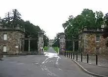
| |
| Newbattle Old Bridge | Newbattle Road, Newbattle | NT3314465712 | 55°52′48″N 3°04′13″W | 16th-century road bridge[55] | 14568 | 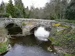
| |
| Lady Victoria Colliery | Newtongrange | NT3326263693 | 55°51′42″N 3°04′04″W | Late 19th to mid-20th century, now the Scottish Mining Museum[56] | 14604 | 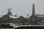
| |
| Arniston House, Walled Garden | Gorebridge | NT3252759109 | 55°49′14″N 3°04′42″W | 18th-century walled garden[57] | 14625 |
| |
| Rosebery Home Farm | Temple | NT3025857458 | 55°48′19″N 3°06′51″W | Early-19th-century Gothic farm[58] | 14630 | 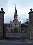
| |
| Penicuik House | Penicuik | NT2172659208 | 55°49′11″N 3°15′03″W | Shell of 18th-century country house by Sir James Clerk, 3rd Baronet, burned out in 1899, currently under major restoration[59] | 14634 | 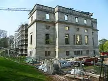
| |
| New Penicuik House | Penicuik | NT2168859366 | 55°49′16″N 3°15′05″W | Former stable block, converted after the main house burned out in 1899[60] | 14635 | 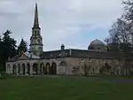
| |
| Fairfield House hot house | Croft Street, Dalkeith | NT3321167040 | 55°53′31″N 3°04′10″W | Early- to mid-19th-century glasshouse[61] | 24339 |
| |
| St David's RC Church | Eskbank Road, Dalkeith | NT3282266921 | 55°53′27″N 3°04′32″W | Mid-19th-century gothic church[62] | 24355 | 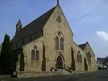
| |
| Eskbank House | 14 Glenesk Crescent, Dalkeith | NT3255966872 | 55°53′25″N 3°04′47″W | 18th-century villa[63] | 24375 |
| |
| Dalkeith Old Kirk | High Street, Dalkeith | NT3325867442 | 55°53′44″N 3°04′08″W | 15th century, remodelled by David Bryce, includes watch house in graveyard[64] | 24377 | 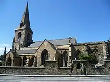
| |
| Dalkeith Tolbooth | 176-180 High Street, Dalkeith | NT3332367436 | 55°53′43″N 3°04′04″W | 18th-century town hall[65] | 24417 | 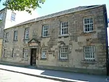
| |
| Dalkeith Corn Exchange | 200 High Street And 61 St Andrew Street, Dalkeith | NT3339967526 | 55°53′46″N 3°04′00″W | Mid-19th-century hall by David Cousin[66] | 24422 | 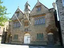
| |
| Linsandel House | 12 Melville Road, Dalkeith | NT3246366773 | 55°53′22″N 3°04′53″W | 19th-century Italianate villa[67] | 24443 |
| |
| Dalkeith Lodge (Newbattle Abbey West Lodge) | Newmills Road, Dalkeith | NT3337967047 | 55°53′31″N 3°04′00″W | Mid-19th-century Gothic gateway and lodge[68] | 24452 |
| |
| 22-34 Bridge Street and 1-7 Park End | Penicuik | NT2356559726 | 55°49′29″N 3°13′18″W | 19th-century Gothic shops and tenements by F T Pilkington[69] | 39294 | 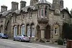
| |
| Penicuik South Church | Peebles Road, Penicuik | NT2357959504 | 55°49′22″N 3°13′17″W | 19th-century Gothic church by F T Pilkington[70] | 39295 | 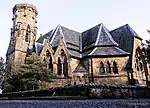
| |
| Mavisbank House, Walled Garden | Loanhead | NT2893565072 | 55°52′25″N 3°08′14″W | 18th-century walled garden[71] | 44166 |
| |
| Glencorse Barracks Clock Tower | Glencorse, Penicuik | NT2474861993 | 55°50′43″N 3°12′12″W | Early-19th-century clock tower and prison[72] | 44614 |
|
See also
Notes
- Sometimes known as OSGB36, the grid reference (where provided) is based on the British national grid reference system used by the Ordnance Survey.
• "Guide to National Grid". Ordnance Survey. Retrieved 2007-12-12.
• "Get-a-map". Ordnance Survey. Retrieved 2007-12-17. - Historic Environment Scotland assign a unique alphanumeric identifier to each designated site in Scotland, for listed buildings this always begins with "LB", for example "LB12345".
References
- Guide to the Protection of Scotland’s Listed Buildings (PDF). Historic Scotland. 2009. p. 4. ISBN 978-1-84917-013-0. Retrieved 2010-05-05.
- "What is Listing?". Historic Scotland. Retrieved 2010-05-05.
- Scottish Historic Environment Policy (PDF). Historic Scotland. October 2008. pp. 24–25. ISBN 978-1-84917-002-4. Retrieved 2010-05-05.
- Guide to the Protection of Scotland’s Listed Buildings, p. 17.
- "Preston Hall Policies, Stables Including Kennels, Piggery, Pheasantry And Cottages, Listed Building Report". Historic Scotland. Retrieved 2010-06-05.
- "Whitehill Policies, Whitehill House, Former St Joseph's Institution, Listed Building Report". Historic Scotland. Retrieved 2010-06-05.
- "Preston Hall Policies, North Gate, Listed Building Report". Historic Scotland. Retrieved 2010-06-05.
- "Preston Hall Policies, The Lions Gate, Listed Building Report". Historic Scotland. Retrieved 2010-06-05.
- "Crichton Kirk (Formerly Collegiate Church Of S.S. Mary And Kentigern) Including Graveyard, Listed Building Report". Historic Scotland. Retrieved 2010-06-05.
- "Ford, Ford House And Walled Garden, Listed Building Report". Historic Scotland. Retrieved 2010-06-05.
- "Crichton House, East And West Wings, Listed Building Report". Historic Scotland. Retrieved 2010-06-05.
- "Oxenfoord Castle, Listed Building Report". Historic Scotland. Retrieved 2010-06-05.
- "Oxenfoord Viaduct, Listed Building Report". Historic Scotland. Retrieved 2010-06-05.
- "Preston Hall, Listed Building Report". Historic Scotland. Retrieved 2010-06-05.
- "Preston Hall Policies, Walled Garden Including Sheds, Gazebos, Glass Houses, Sundial And Gardener's House, Listed Building Report". Historic Scotland. Retrieved 2010-06-05.
- "Preston Hall Policies, The Temple, Listed Building Report". Historic Scotland. Retrieved 2010-06-05.
- "Cockpen And Carrington Parish Church, Including Gates, Gatepiers, Boundary Wall And Letter Box, Listed Building Report". Historic Scotland. Retrieved 2010-06-05.
- "Dalhousie Castle, Listed Building Report". Historic Scotland. Retrieved 2010-06-05.
- "Vogrie House, Listed Building Report". Historic Scotland. Retrieved 2010-06-05.
- "Borthwick Castle, Including Outer Walls And Gatehouse, Listed Building Report". Historic Scotland. Retrieved 2010-06-05.
- "Middleton Hall, Including Gatepiers, Gates, Ha-Ha And Boundary Walls, Listed Building Report". Historic Scotland. Retrieved 2010-06-05.
- "Arniston House, Including Stable Block, Outbuildings, Orangery, Ha-Ha And Sundial, Listed Building Report". Historic Scotland. Retrieved 2010-06-05.
- "Arniston Policies, Grotto, Listed Building Report". Historic Scotland. Retrieved 2010-06-05.
- "Arniston Policies, North Lodge, And Lion And Elephant Gate, Including Gates And Gatepiers, Listed Building Report". Historic Scotland. Retrieved 2010-06-05.
- "Dalkeith Park, Conservatory, Listed Building Report". Historic Scotland. Retrieved 2010-06-05.
- "Dalkeith Park, Dalkeith House, With Retaining Wall And Lamp Standards, Listed Building Report". Historic Scotland. Retrieved 2010-06-05.
- "Dalkeith Park, Dark Walk, Gateway And Walls, Listed Building Report". Historic Scotland. Retrieved 2010-06-05.
- "Dalkeith Park, King's Gate, Walls And Lodge, Listed Building Report". Historic Scotland. Retrieved 2010-06-05.
- "Dalkeith Park, Montagu Bridge Including Cauld, Listed Building Report". Historic Scotland. Retrieved 2010-06-05.
- "Dalkeith Park, St Mary's Episcopal Chapel, With Lamp Standard, Listed Building Report". Historic Scotland. Retrieved 2010-06-05.
- "Dalkeith Park, Stables And Coach House, Listed Building Report". Historic Scotland. Retrieved 2010-06-05.
- "Glenesk Railway Viaduct, Listed Building Report". Historic Scotland. Retrieved 2010-06-05.
- "Lothian Bridge, Tyne Valley, Listed Building Report". Historic Scotland. Retrieved 2010-06-05.
- "Mavisbank House, Doocot, Listed Building Report". Historic Scotland. Retrieved 2010-06-05.
- "Mavisbank House, Gazebo, Listed Building Report". Historic Scotland. Retrieved 2010-06-05.
- "Melville Castle, Listed Building Report". Historic Scotland. Retrieved 2010-06-05.
- "Lasswade, Wadingburn Road, Barony House (Formerly Lasswade Cottage), Listed Building Report". Historic Scotland. Retrieved 2010-06-05.
- "Mavisbank House, (Formerly New Saughtonhall), Including Service Wing, Terraces, Retaining Walls, And Steps, Listed Building Report". Historic Scotland. Retrieved 2010-06-05.
- "Glencorse, Old Glencorse Kirk, Listed Building Report". Historic Scotland. Retrieved 2010-06-05.
- "Glencorse Parish Church, Listed Building Report". Historic Scotland. Retrieved 2010-06-05.
- "The Bush House Including Stables, Laundry House, Boundary Walls, Gatepiers And Gates, Listed Building Report". Historic Scotland. Retrieved 2010-06-05.
- "Melville Castle, Willie's Temple, Listed Building Report". Historic Scotland. Retrieved 2010-06-05.
- "Hawthornden Castle, Including Gatepiers, Boundary Walls, Wellhead Drinking Fountainhead And Outbuilding, Listed Building Report". Historic Scotland. Retrieved 2010-06-05.
- "Rosslyn Castle, Including Bridge, Listed Building Report". Historic Scotland. Retrieved 2010-06-05.
- "Rosslyn Chapel (Episcopal), Formerly Collegiate Church Of St Matthew, Including Vaults, Burial Ground And Boundary Walls, Listed Building Report". Historic Scotland. Retrieved 2010-06-05.
- "Auchindinny House, Including Gatepiers, Boundary Walls And Outbuildings, Listed Building Report". Historic Scotland. Retrieved 2010-06-05.
- "Bilston Railway Viaduct Over Bilston Burn, Listed Building Report". Historic Scotland. Retrieved 2010-06-05.
- "Danderhall Miners' Club, Woolmet House Gateway And Boundary Wall, Listed Building Report". Historic Scotland. Retrieved 2010-06-05.
- "Newbattle, Newbattle Abbey, Listed Building Report". Historic Scotland. Retrieved 2010-06-05.
- "Newbattle Abbey Policies, North Sundial, Listed Building Report". Historic Scotland. Retrieved 2010-06-05.
- "Newbattle Abbey Policies, South Sundial, Listed Building Report". Historic Scotland. Retrieved 2010-06-05.
- "Newbattle Abbey Policies, Maiden Bridge, Listed Building Report". Historic Scotland. Retrieved 2010-06-05.
- "Newbattle Abbey Policies, Newbattle Road, Monkland Wall, Listed Building Report". Historic Scotland. Retrieved 2010-06-05.
- "Newbattle Abbey Policies, Port Lodge Including Quadrant Colonnades And Gatepiers, Listed Building Report". Historic Scotland. Retrieved 2010-06-05.
- "Newbattle, Newbattle Road, Old Bridge, Listed Building Report". Historic Scotland. Retrieved 2010-06-05.
- "Newtongrange, Lady Victoria Colliery, Listed Building Report". Historic Scotland. Retrieved 2010-06-05.
- "Arniston Policies, Walled Garden, Including Gateways And Loggia, Listed Building Report". Historic Scotland. Retrieved 2010-06-05.
- "Rosebery House Policies, Home Farm, Listed Building Report". Historic Scotland. Retrieved 2010-06-05.
- "Old Penicuik House, Listed Building Report". Historic Scotland. Retrieved 2010-06-05.
- "New Penicuik House (Formerly Stables), Listed Building Report". Historic Scotland. Retrieved 2010-06-05.
- "Croft Street, Fairfield House, Hot House, Listed Building Report". Historic Scotland. Retrieved 2010-06-05.
- "Eskbank Road, St David's Church (Roman Catholic), With Boundary Walls And Gatepiers, Listed Building Report". Historic Scotland. Retrieved 2010-06-05.
- "14 Glenesk Crescent, Eskbank House, With Boundary Walls And Gatepiers, Listed Building Report". Historic Scotland. Retrieved 2010-06-05.
- "High Street, Old Kirk (Church Of Scotland, Formerly East Church (St Nicholas)), With Graveyard Walls And Watch House, Listed Building Report". Historic Scotland. Retrieved 2010-06-05.
- "176-180 (Even Nos) High Street, Dalkeith Tolbooth, Listed Building Report". Historic Scotland. Retrieved 2010-06-05.
- "200 High Street And 61 St Andrew Street, Corn Exchange, Listed Building Report". Historic Scotland. Retrieved 2010-06-05.
- "12 Melville Road, Linsandel House, With Outbuildings, Boundary Walls, Gates And Gatepiers, Listed Building Report". Historic Scotland. Retrieved 2010-06-05.
- "Newmills Road, Dalkeith Lodge (Newbattle Abbey West Lodge), With Gateway And Adjoining Wall, Listed Building Report". Historic Scotland. Retrieved 2010-06-05.
- "22-34 (Even Nos) Bridge Street And 1-7 (Inclusive Nos) Park End, Including Archway, Listed Building Report". Historic Scotland. Retrieved 2010-06-05.
- "Peebles Road, Penicuik South Church (Church Of Scotland), Including Boundary Walls And Gatepiers, Listed Building Report". Historic Scotland. Retrieved 2010-06-05.
- "Mavisbank House, Walled Gardens, Including Gates And Gatepiers, Listed Building Report". Historic Scotland. Retrieved 2010-06-05.
- "Glencorse Barracks, Clock Tower, Listed Building Report". Historic Scotland. Retrieved 2010-06-05.
External links
![]() Media related to Category A listed buildings in Midlothian at Wikimedia Commons
Media related to Category A listed buildings in Midlothian at Wikimedia Commons