List of Category A listed buildings in Falkirk
This is a list of Category A listed buildings in the Falkirk council area, central Scotland.
In Scotland, the term listed building refers to a building or other structure officially designated as being of "special architectural or historic interest".[1] Category A structures are those considered to be "buildings of national or international importance, either architectural or historic, or fine little-altered examples of some particular period, style or building type."[2] Listing was begun by a provision in the Town and Country Planning (Scotland) Act 1947, and the current legislative basis for listing is the Planning (Listed Buildings and Conservation Areas) (Scotland) Act 1997.[3] The authority for listing rests with Historic Scotland, an executive agency of the Scottish Government, which inherited this role from the Scottish Development Department in 1991. Once listed, severe restrictions are imposed on the modifications allowed to a building's structure or its fittings. Listed building consent must be obtained from local authorities prior to any alteration to such a structure.[3] There are approximately 47,400 listed buildings in Scotland, of which around 8% (some 3,800) are Category A.[4]
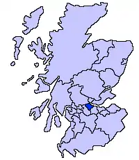
The council area of Falkirk covers 297 square kilometres (115 sq mi), and has a population of around 151,600. There are 27 Category A listed buildings in the area.
Listed buildings
| Name | Location | Date Listed | Grid Ref. [note 1] | Geo-coordinates | Notes | LB Number [note 2] | Image |
|---|---|---|---|---|---|---|---|
| Blackness Castle | Blackness | NT0554580253 | 56°00′21″N 3°30′59″W | 15th-century castle with later alterations[5] | 230 | 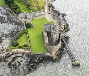
| |
| Airth Mercat Cross | Airth | NS8990587534 | 56°04′05″N 3°46′12″W | Late 17th-century market cross[6] | 2095 | 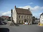
| |
| Airth Castle | Airth | NS9000786834 | 56°03′42″N 3°46′05″W | 16th-century castle with a 19th-century facade by David Hamilton[7] | 2102 | 
| |
| Dunmore Pineapple | Dunmore Park, Dunmore | NS8889388537 | 56°04′36″N 3°47′12″W | 18th-century garden building in the shape of a pineapple[8] | 2109 | 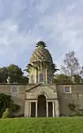
| |
| Torwood Castle | Torwood | NS8359084368 | 56°02′17″N 3°52′12″W | Remains of 16th-century tower house[9] | 3962 | 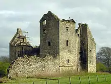
| |
| Parkhill House | Polmont | NS9288578791 | 55°59′24″N 3°43′07″W | Late 18th-century mansion[10] | 8301 | 
| |
| Westquarter Dovecot | Westquarter | NS9132978716 | 55°59′21″N 3°44′37″W | 17th-century rectangular dovecote[11] | 8315 | .jpg.webp)
| |
| Royal Scottish National Hospital, Principal Block | Larbert | NS8585883627 | 56°01′55″N 3°50′00″W | 19th-century former hospital by Frederick Thomas Pilkington[12] | 10481 | 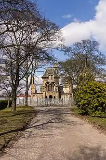
| |
| Carronvale House | Larbert | NS8671781980 | 56°01′02″N 3°49′08″W | 18th-century house remodelled 1897 by Sir John Burnet[13] | 10487 |
| |
| Larbert Old Parish Churchyard and monuments | Larbert | NS8552882203 | 56°01′08″N 3°50′17″W | Churchyard with several significant graves including James Bruce of Kinnaird and Mary Dundas[14] | 10496 |
| |
| Stenhouse and Carron Parish Church, former Maclaren Memorial Church | Stenhousemuir | NS8758783070 | 56°01′38″N 3°48′19″W | Romanesque church of circa 1900 by John James Burnet[15] | 10503 |
| |
| Castlecary Castle | Castlecary | NS7866377526 | 55°58′31″N 3°56′45″W | 15th-century tower house[16] | 10519 | 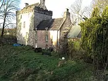
| |
| Avon Aqueduct [note 3] | Union Canal, over River Avon | NS9672575812 | 55°57′51″N 3°39′22″W[note 3]) | 12-arch aqueduct opened 1822[17] | 15321 | 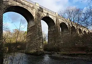
| |
| Avon Viaduct [note 3] | Westfield, over River Avon | NS9335072686 | 55°56′07″N 3°42′32″W[note 3]) | 20-arch former railway viaduct opened 1842[18] | 15326 | 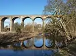
| |
| Bo'ness Station | Bo'ness | NT0039681708 | 56°01′04″N 3°35′58″W | 19th-century railway station buildings, now part of Bo'ness and Kinneil Railway[19] | 22337 | 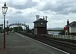
| |
| Carriden House | Carriden, Bo'ness | NT0249980834 | 56°00′38″N 3°33′55″W | 17th-century mansion[20] | 22339 | 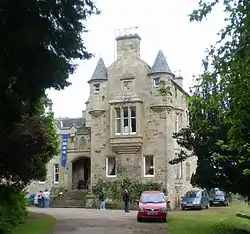
| |
| Church Wynd, Graveyards | Bo'ness | NS9968981488 | 56°00′57″N 3°36′38″W | Two graveyards with monuments of 17th century and later[21] | 22350 | .jpg.webp)
| |
| Kinneil House | Kinneil, Bo'ness | NS9819780557 | 56°00′26″N 3°38′03″W | Late 15th-century tower house with 16th- and 17th-century remodelling[22] | 22358 | 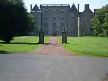
| |
| 49 North Street, Dymock's Buildings | Bo'ness | NS9982281720 | 56°01′04″N 3°36′31″W | Late-17th-century town houses and industrial buildings[23] | 22379 | 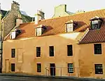
| |
| The Hippodrome | Bo'ness | NS9984281686 | 56°01′03″N 3°36′30″W | Early Modern cinema by Matthew Steele, 1911[24] | 22380 | 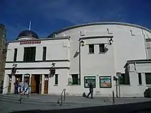
| |
| Falkirk Old Parish Church | Falkirk, High Street | NS8872980025 | 56°00′01″N 3°47′09″W | Medieval church, mostly rebuilt in the 19th century, spire added by William Adam, 1738[25] | 31167 | 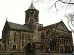
| |
| Falkirk Steeple | Falkirk, High Street | NS8882479913 | 55°59′57″N 3°47′03″W | Classical clock tower by David Hamilton, 1814 [26] | 31178 | 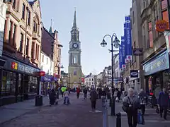
| |
| Callendar House | Callendar Park, Falkirk | NS8986479352 | 55°59′40″N 3°46′02″W | 14th-century tower house with later additions, remodelled in French style by Brown and Wardrop, 1877[27] | 31236 | 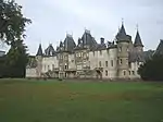
| |
| Callendar House Mausoleum | Callendar Park, Falkirk | NS9038678990 | 55°59′29″N 3°45′32″W | Classical mausoleum by Archibald Elliot, 1816[28] | 31241 | .jpg.webp)
| |
| St Mary's Roman Catholic Church | Camelon | NS8641780573 | 56°00′17″N 3°49′23″W | Church of 1960 by Gillespie Kidd and Coia[29] | 31252 | 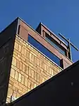
| |
| Dundas Church | Grangemouth | NS9291381991 | 56°01′08″N 3°43′10″W | Romanesque church of 1894 by John James Burnet[30] | 34041 |
|
See also
Notes
- Sometimes known as OSGB36, the grid reference (where provided) is based on the British national grid reference system used by the Ordnance Survey.
• "Guide to National Grid". Ordnance Survey. Retrieved 2007-12-12.
• "Get-a-map". Ordnance Survey. Retrieved 2007-12-17. - Historic Environment Scotland assign a unique alphanumeric identifier to each designated site in Scotland, for listed buildings this always begins with "LB", for example "LB12345".
- Also in West Lothian, as it crosses the River Avon which is the council boundary
References
- Guide to the Protection of Scotland's Listed Buildings (PDF). Historic Scotland. 2009. p. 4. ISBN 978-1-84917-013-0. Retrieved 2010-05-05.
- "What is Listing?". Historic Scotland. Retrieved 2010-05-05.
- Scottish Historic Environment Policy (PDF). Historic Scotland. October 2008. pp. 24–25. ISBN 978-1-84917-002-4. Retrieved 2010-05-05.
- Guide to the Protection of Scotland’s Listed Buildings, p. 17.
- "Blackness Castle: Listed Building Report". Historic Scotland.
- "Airth Mercat Cross: Listed Building Report". Historic Scotland.
- "Airth Castle: Listed Building Report". Historic Scotland.
- "Garden Wall And Pineapple, Dunmore Park: Listed Building Report". Historic Scotland.
- "Torwood Castle: Listed Building Report". Historic Scotland.
- "Parkhill House: Listed Building Report". Historic Scotland.
- "Dovecot, Dovecot Road, Westquarter: Listed Building Report". Historic Scotland.
- "Royal Scottish National Hospital, Principal Block (Private House) With Boundary Walls And Gatepiers: Listed Building Report". Historic Scotland.
- "Carronvale Road, 'Carronvale' (Boy's Brigade Hq): Listed Building Report". Historic Scotland.
- "Old Parish Church Churchyard And Monument To James Bruce Of Kinnaird And Mary Dundas: Listed Building Report". Historic Scotland.
- "Stenhousemuir, Church Street, Parish Church Of Stenhouse And Carron, Former Maclaren Memorial Church, Church Of Scotland: Listed Building Report". Historic Scotland.
- "Castle Cary: Listed Building Report". Historic Scotland.
- "Avon Aqueduct: Listed Building Report". Historic Scotland.
- "Avon Viaduct: Listed Building Report". Historic Scotland.
- "Bo'ness Station, Former Haymarket Train Shed, Former Wormit Station Building, Signal Box, Footbridge, Goods Office, Goods Yard, Water Tank And Lamp Standards: Listed Building Report". Historic Scotland.
- "Carriden, Carriden House Including Boundary Walls: Listed Building Report". Historic Scotland.
- "Church Wynd, Graveyards Including Boundary Walls: Listed Building Report". Historic Scotland.
- "Kinneil, Kinneil House Including Gatepiers To West And East And Boundary Walls: Listed Building Report". Historic Scotland.
- "49 North Street, Dymock's Buildings With Scotland's Close Warehouse And Service Court: Listed Building Report". Historic Scotland.
- "North Street, The Hippodrome: Listed Building Report". Historic Scotland.
- "Old Parish Church And Burial Ground Including Boundary Walls And Railings: Listed Building Report". Historic Scotland.
- "Falkirk Town Steeple. High Street: Listed Building Report". Historic Scotland.
- "Callendar Park, Callendar House: Listed Building Report". Historic Scotland.
- "Callendar Park, Callendar House Mausoleum: Listed Building Report". Historic Scotland.
- "Glasgow Road, Camelon, St Mary Of The Angels Roman Catholic Church And Presbytery: Listed Building Report". Historic Scotland.
- "Dundas Church Bo'ness Road: Listed Building Report". Historic Scotland.
External links
![]() Media related to Category A listed buildings in Falkirk council area at Wikimedia Commons
Media related to Category A listed buildings in Falkirk council area at Wikimedia Commons