List of Category A listed buildings in East Ayrshire
This is a list of Category A listed buildings in East Ayrshire, Scotland.
In Scotland, the term listed building refers to a building or other structure officially designated as being of "special architectural or historic interest".[1] Category A structures are those considered to be "buildings of national or international importance, either architectural or historic, or fine little-altered examples of some particular period, style or building type."[2] Listing was begun by a provision in the Town and Country Planning (Scotland) Act 1947, and the current legislative basis for listing is the Planning (Listed Buildings and Conservation Areas) (Scotland) Act 1997.[3] The authority for listing rests with Historic Scotland, an executive agency of the Scottish Government, which inherited this role from the Scottish Development Department in 1991. Once listed, severe restrictions are imposed on the modifications allowed to a building's structure or its fittings. Listed building consent must be obtained from local authorities prior to any alteration to such a structure.[3] There are approximately 47,400 listed buildings in Scotland, of which around 8% (some 3,800) are Category A.[4]
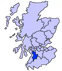
The council area of East Ayrshire covers 1,262 square kilometres (487 sq mi), and has a population of around 119,900. There are 45 Category A listed buildings in the area.
Listed buildings
| Name | Location | Date Listed | Grid Ref. [note 1] | Geo-coordinates | Notes | LB Number [note 2] | Image |
|---|---|---|---|---|---|---|---|
| Dumfries House, The Temple | Dumfries House estate, near Cumnock | NS5390821384 | 55°27′52″N 4°18′44″W | Pair of ruined lodges forming part of the Dumfries House estate[5] | 96 | 
| |
| Auchinleck House | Auchinleck | NS5072623016 | 55°28′41″N 4°21′48″W | House of c. 1760, by Robert Adam[6] | 948 | 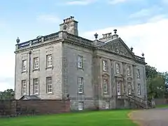
| |
| Waterside Engine House | Waterside Ironworks, Dalmellington | NS4417308383 | 55°20′41″N 4°27′32″W | Mid 19th-century industrial building[7] | 1092 |
| |
| The Hill | Dunlop | NS4127648835 | 55°42′25″N 4°31′40″W | Mid 18th-century farmhouse[8] | 5184 |
| |
| Dunlop House | Dunlop | NS4273749312 | 55°42′42″N 4°30′17″W | Baronial house of 1834 by David Hamilton[9] | 5187 | 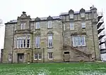
| |
| Clandeboye Vault | Dunlop Parish Church Graveyard, Dunlop | NS4048649398 | 55°42′42″N 4°32′26″W | 1641 tomb of Hans Hamilton, first Protestant minister of Dunlop[10] | 5191 | 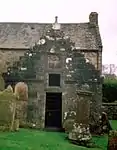
| |
| Clandeboye Schoolhouse | Main Street, Dunlop | NS4048949397 | 55°42′42″N 4°32′26″W | School founded in 1641 by Viscount Clandeboye, one of the oldest surviving school buildings in Scotland[11] | 5192 |
| |
| Kirkland | Main Street, Dunlop | NS4064849471 | 55°42′45″N 4°32′17″W | Early-16th-century former manse, one of the oldest unfortified houses to survive in Scotland[12] | 5194 | 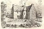
| |
| Rowallan Castle | Kilmaurs | NS4347242427 | 55°39′00″N 4°29′21″W | 16th- to 17th-century Baronial mansion[13] | 12523 | 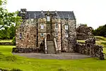
| |
| Rowallan House | Kilmaurs | NS4327742725 | 55°39′10″N 4°29′33″W | Country house by Robert Lorimer, completed 1906[14] | 12524 |
| |
| Craufurdland Castle | Near Kilmarnock | NS4558540798 | 55°38′10″N 4°27′17″W | 19th-century Gothic house incorporating 17th-century and earlier buildings[15] | 12530 |
| |
| Loudoun Castle | Galston | NS5065337776 | 55°36′38″N 4°22′21″W | 1807 country house by Archibald Elliot, now in ruins[16] | 12536 | 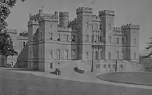
| |
| Laigh Milton Viaduct | Over the River Irvine at Gatehead | NS3834936902 | 55°35′56″N 4°34′02″W | The earliest surviving railway bridge in Scotland, opened in 1812[17] | 12556 | 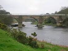
| |
| Cessnock Castle | Galston | NS5107635517 | 55°35′26″N 4°21′53″W | Late-19th-century mansion, incorporating an earlier tower house[18] | 12562 |
| |
| Tour Dovecot | Kilmaurs | NS4138140664 | 55°38′01″N 4°31′17″W | Dovecote dated 1636[19] | 12578 | 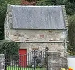
| |
| Kilmaurs Tolbooth | Kilmaurs | NS4104141210 | 55°38′18″N 4°31′37″W | Former parish council chambers and jail[20] | 12588 | 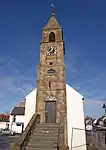
| |
| Alexander Morton Monument | Beside A71 between Newmilns and Darvel | NS5521637472 | 55°36′33″N 4°18′00″W | Monument by Robert Lorimer, completed 1927[21] | 13461 |
| |
| Sornhill Farm | Galston | NS5095834140 | 55°34′41″N 4°21′57″W | 17th- to 18th-century farmhouse[22] | 13829 |
| |
| Catrine Parish Church | Catrine | NS5276026004 | 55°30′20″N 4°19′58″W | Late-18th-century chapel of ease[23] | 14264 | 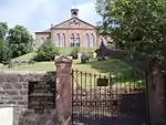
| |
| Sorn Old Bridge | Over River Ayr at Sorn | NS5496626731 | 55°30′46″N 4°17′54″W | Hump-backed stone bridge[24] | 14272 | 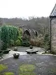
| |
| Sorn Castle | Sorn | NS5480426913 | 55°30′52″N 4°18′04″W | 16th-century tower house with 18th- and 19th-century additions[25] | 14273 | 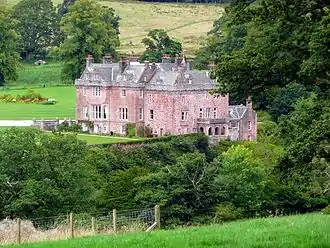
| |
| Sorn Castle Stables | Sorn | NS5455327026 | 55°30′55″N 4°18′18″W | Early-19th- or late-18th-century classical courtyard[26] | 14274 |
| |
| Stair Bridge | Over the River Ayr at Stair | NS4376623477 | 55°28′48″N 4°28′25″W | Three-arch bridge built 1745[27] | 14371 | 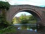
| |
| Stair House | Stair | NS4400123808 | 55°28′59″N 4°28′13″W | 17th-century country house[28] | 14372 | 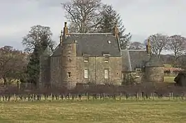
| |
| Dumfries House | Cumnock | NS5414120398 | 55°27′20″N 4°18′29″W | Country house built 1759 to designs by John, Robert and James Adam[29] | 14413 | 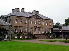
| |
| Dumfries House, Avenue Bridge | Over the River Lugar in Dumfries House estate, Cumnock | NS5379820643 | 55°27′28″N 4°18′49″W | Three-arch bridge contemporary with the house[30] | 14414 | 
| |
| Dumfries House Dovecote | Dumfries House estate, Cumnock | NS5395120350 | 55°27′19″N 4°18′40″W | 17th-century dovecote[31] | 14416 | 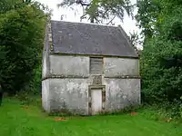
| |
| Mauchline Castle (Abbot Hunter's Tower) | Mauchline | NS4977127264 | 55°30′57″N 4°22′51″W | Former grange of Melrose Abbey, c. 1450[32] | 14471 | 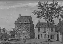
| |
| Ballochmyle Viaduct | Over the River Ayr near Mauchline | NS5087925392 | 55°29′58″N 4°21′44″W | Railway viaduct opened in 1850[33] | 14483 | 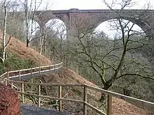
| |
| Kennox House | West of Stewarton | NS3846944946 | 55°40′16″N 4°34′12″W | Mid-18th-century house with substantial early-19th-century additions[34] | 18490 |
| |
| High Williamshaw | North-east of Stewarton | NS4400748326 | 55°42′12″N 4°29′02″W | Late-18th-century gentleman's house[35] | 18496 | 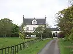
| |
| Treesbanks House Dovecot | Ayr Road, Kilmarnock | NS4196234522 | 55°34′43″N 4°30′31″W | Dovecote of 1771[36] | 18512 |
| |
| Caprington Castle | West of Kilmarnock | NS4077536251 | 55°35′38″N 4°31′42″W | Gothic mansion of c. 1820, incorporating and earlier building[37] | 18517 | 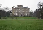
| |
| Craigengillan | South of Dalmellington | NS4735002817 | 55°17′45″N 4°24′21″W | 18th-century house, enlarged in the Gothic style in the 19th century[38] | 18793 | 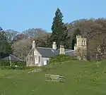
| |
| Craigengillan Stable Block | Craigengillan, south of Dalmellington | NS4736502755 | 55°17′43″N 4°24′20″W | Late-18th-century classical stable court[39] | 18794 | 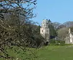
| |
| Loch Doon Castle | Loch Doon | NX4881494758 | 55°13′26″N 4°22′42″W | Remains of an eleven-sided curtain-wall castle[40] | 18795 | 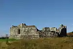
| |
| Barskimming New Bridge | Over River Ayr at Barskimming, Mauchline | NS4821425194 | 55°29′49″N 4°24′16″W | Later 18th-century bridge, with adjacent estate workers' houses and a viewing platform[41] | 19483 | 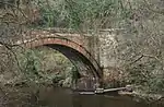
| |
| Cumnock Mercat Cross | The Square, Cumnock | NS5678320132 | 55°27′14″N 4°15′58″W | Mercat cross dating to 1703[42] | 24093 | 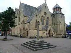
| |
| Bank (or Templand) Railway Viaduct | Over Lugar Water in Woodroad Park, Cumnock | NS5739520624 | 55°27′31″N 4°15′24″W | 13-arch viaduct completed 1850[43] | 24133 | 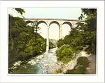
| |
| St Sophia's Roman Catholic Church | Bentinck Street, Galston | NS5028436510 | 55°35′57″N 4°22′40″W | Byzantine-style church of 1886 by Robert Weir Schultz[44] | 32010 | 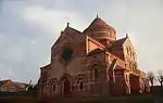
| |
| Laigh Kirk | Bank Street, Kilmarnock | NS4276737948 | 55°36′35″N 4°29′52″W | Early-19th-century church with 17th-century tower[45] | 35875 | .jpg.webp)
| |
| Dean Castle | Dean Road, Kilmarnock | NS4368439416 | 55°37′23″N 4°29′02″W | Late-14th- or early-15th-century tower house with later additions, restored in the 20th century[46] | 35884 | 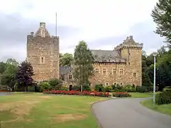
| |
| Palace Theatre, former Corn Exchange | Green Street, Kilmarnock | NS4298237941 | 55°36′35″N 4°29′40″W | Italianate corn exchange built 1863 by James Ingram, converted in the 20th century[47] | 35903 | 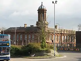
| |
| Holy Trinity Episcopal Church | Dundonald Road, Kilmarnock | NS4258737720 | 55°36′27″N 4°30′02″W | Mid 19th-century church, extended in 1876 by George Gilbert Scott[48] | 35946 | 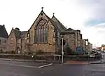
| |
| Old High Kirk, including kirkyard with Soulis Monument | Soulis Street, Kilmarnock | NS4296838249 | 55°36′45″N 4°29′41″W | Church of 1740, to designs taken from a James Gibbs pattern book[49] | 35965 | .jpg.webp)
|
Notes
- Sometimes known as OSGB36, the grid reference (where provided) is based on the British national grid reference system used by the Ordnance Survey.
• "Guide to National Grid". Ordnance Survey. Retrieved 2007-12-12.
• "Get-a-map". Ordnance Survey. Retrieved 2007-12-17. - Historic Environment Scotland assign a unique alphanumeric identifier to each designated site in Scotland, for listed buildings this always begins with "LB", for example "LB12345".
References
- Guide to the Protection of Scotland's Listed Buildings (PDF). Historic Scotland. 2009. p. 4. ISBN 978-1-84917-013-0. Retrieved 2010-05-05.
- "What is Listing?". Historic Scotland. Retrieved 2010-05-05.
- Scottish Historic Environment Policy (PDF). Historic Scotland. October 2008. pp. 24–25. ISBN 978-1-84917-002-4. Retrieved 2010-05-05.
- Guide to the Protection of Scotland’s Listed Buildings, p. 17.
- "The Temple, in Policies of Dumfries House: Listed Building Report". Historic Scotland. Retrieved 2010-06-05.
- "Auchinleck House: Listed Building Report". Historic Scotland. Retrieved 2010-06-05.
- "Waterside Engine House: Listed Building Report". Historic Scotland. Retrieved 2010-06-05.
- "The Hill, with ancillary buildings, boundary walls, gates and gatepiers: Listed Building Report". Historic Scotland. Retrieved 2010-06-05.
- "Dunlop House With Bridge: Listed Building Report". Historic Scotland. Retrieved 2010-06-05.
- "Main Street, Parish Church Graveyard, Hans Hamilton's Tomb: Listed Building Report". Historic Scotland. Retrieved 2010-06-05.
- "Main Street, Clandeboye School: Listed Building Report". Historic Scotland. Retrieved 2010-06-05.
- "62 Main Street, Kirkland, with former coach house and stables, boundary wall, gates and gatepiers: Listed Building Report". Historic Scotland. Retrieved 2010-06-05.
- "Rowallan Castle: Listed Building Report". Historic Scotland. Retrieved 2010-06-05.
- "Rowallan House: Listed Building Report". Historic Scotland. Retrieved 2010-06-05.
- "Crawfurdland Castle: Listed Building Report". Historic Scotland. Retrieved 2010-06-05.
- "Loudoun Castle: Listed Building Report". Historic Scotland. Retrieved 2010-06-05.
- "Disused Railway Viaduct Near West Gatehead: Listed Building Report". Historic Scotland. Retrieved 2010-06-05.
- "Cessnock Castle: Listed Building Report". Historic Scotland. Retrieved 2010-06-05.
- "Dovecote, Tour Garden: Listed Building Report". Historic Scotland. Retrieved 2010-06-05.
- "Tolbooth: Listed Building Report". Historic Scotland. Retrieved 2010-06-05.
- "Alexander Morton Monument, beside A71 between Newmilns and Darvel: Listed Building Report". Historic Scotland. Retrieved 2010-06-05.
- "Sornhill Farm: Listed Building Report". Historic Scotland. Retrieved 2010-06-05.
- "Catrine Parish Church: Listed Building Report". Historic Scotland. Retrieved 2010-06-05.
- "Bridge over River Ayr, opposite Sorn Parish Church: Listed Building Report". Historic Scotland. Retrieved 2010-06-05.
- "Sorn Castle: Listed Building Report". Historic Scotland. Retrieved 2010-06-05.
- "Stables, Sorn Castle: Listed Building Report". Historic Scotland. Retrieved 2010-06-05.
- "Stair Bridge: Listed Building Report". Historic Scotland. Retrieved 2010-06-05.
- "Stair House: Listed Building Report". Historic Scotland. Retrieved 2010-06-05.
- "Dumfries House: Listed Building Report". Historic Scotland. Retrieved 2010-06-05.
- "Avenue Bridge, Dumfries House Policies: Listed Building Report". Historic Scotland. Retrieved 2010-06-05.
- "Dovecote, Dumfries House: Listed Building Report". Historic Scotland. Retrieved 2010-06-05.
- "Mauchline Castle (Abbot Hunter's Tower): Listed Building Report". Historic Scotland. Retrieved 2010-06-05.
- "Ballochmyle Railway Viaduct: Listed Building Report". Historic Scotland. Retrieved 2010-06-05.
- "Kennox: Listed Building Report". Historic Scotland. Retrieved 2010-06-05.
- "High Williamshaw: Listed Building Report". Historic Scotland. Retrieved 2010-06-05.
- "Dovecote, Treesbank: Listed Building Report". Historic Scotland. Retrieved 2010-06-05.
- "Caprington Castle: Listed Building Report". Historic Scotland. Retrieved 2010-06-05.
- "Craigengillan: Listed Building Report". Historic Scotland. Retrieved 2010-06-05.
- "Craigengillan, stables: Listed Building Report". Historic Scotland. Retrieved 2010-06-05.
- "Loch Doon Castle: Listed Building Report". Historic Scotland. Retrieved 2010-06-05.
- "Barskimming New Bridge, including estate workers' houses and viewing platform: Listed Building Report". Historic Scotland. Retrieved 2010-06-05.
- "Mercat Cross, The Square: Listed Building Report". Historic Scotland. Retrieved 2010-06-05.
- "Bank (or Templand) Railway Viaduct over Lugar Water in Woodroad Park: Listed Building Report". Historic Scotland. Retrieved 2010-06-05.
- "R.C. Church of St. Sophia: Listed Building Report". Historic Scotland. Retrieved 2010-06-05.
- "Bank Street, The Laigh Kirk: Listed Building Report". Historic Scotland. Retrieved 2010-06-05.
- "Dean Road, Dean Castle and Gatehouse: Listed Building Report". Historic Scotland. Retrieved 2010-06-05.
- "Green Street, Palace Theatre, former Corn Exchange: Listed Building Report". Historic Scotland. Retrieved 2010-06-05.
- "Portland Road, Holy Trinity Episcopal Church including hall, boundary walls, gatepiers and milestone: Listed Building Report". Historic Scotland. Retrieved 2010-06-05.
- "Soulis Street, High Church (Church of Scotland), including churchyard, walls, gatepiers and Soulis Monument: Listed Building Report". Historic Scotland. Retrieved 2010-06-05.
External links
![]() Media related to Category A listed buildings in East Ayrshire at Wikimedia Commons
Media related to Category A listed buildings in East Ayrshire at Wikimedia Commons