List of Category A listed buildings in Stirling
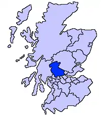
This is a list of Category A listed buildings in the Stirling council area in central Scotland.
In Scotland, the term listed building refers to a building or other structure officially designated as being of "special architectural or historic interest".[1] Category A structures are those considered to be "buildings of national or international importance, either architectural or historic, or fine little-altered examples of some particular period, style or building type."[2] Listing was begun by a provision in the Town and Country Planning (Scotland) Act 1947, and the current legislative basis for listing is the Planning (Listed Buildings and Conservation Areas) (Scotland) Act 1997.[3] The authority for listing rests with Historic Scotland, an executive agency of the Scottish Government, which inherited this role from the Scottish Development Department in 1991. Once listed, severe restrictions are imposed on the modifications allowed to a building's structure or its fittings. Listed building consent must be obtained from local authorities prior to any alteration to such a structure.[3] There are approximately 47,400 listed buildings in Scotland, of which around 8% (some 3,800) are Category A.[4]
The council area of Stirling covers 2,187 square kilometres (844 sq mi), and has a population of around 88,400. There are 84 Category A listed buildings in the area.
Listed buildings
| Name | Location | Date Listed | Grid Ref. [note 1] | Geo-coordinates | Notes | LB Number [note 2] | Image |
|---|---|---|---|---|---|---|---|
| Lecropt Church | Lecropt, Bridge of Allan | NS7805097941 | 56°09′31″N 3°57′54″W | Gothic Church by William Stirling, 1826[5] | 173 | .jpg.webp)
| |
| Keir House, Home Farm | Bridge of Allan | NS7726799296 | 56°10′14″N 3°58′42″W | Farm buildings by David Bryce, 1832, remodelled by Sir William Stirling-Maxwell, 1861[6] | 3918 | 
| |
| Keir House, South Lodge | Bridge of Allan | NS7757099093 | 56°10′07″N 3°58′24″W | Greek Revival lodge by David Hamilton, 1820[7] | 3921 |
| |
| Keir House | Bridge of Allan | NS7697098807 | 56°09′58″N 3°58′58″W | Georgian mansion, extended by David Hamilton in 1831 and Robert Rowand Anderson in 1901[8] | 3935 | 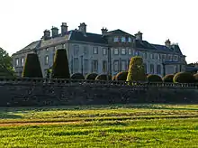
| |
| Old Auchentroig | Auchentroig, Buchlyvie | NS5444693521 | 56°06′44″N 4°20′32″W | Laird's house dated 1702, restored by Simpson & Brown 1999[9] | 3937 |
| |
| Queen Victoria School | Dunblane | NN7893202634 | 56°12′03″N 3°57′11″W | Scots Renaissance school by John A. Campbell, 1908[10] | 3986 |
| |
| Queen Victoria School Memorial Chapel | Dunblane | NN7894902541 | 56°12′00″N 3°57′10″W | Scots Gothic chapel by John A. Campbell, 1908[11] | 3987 |
| |
| Cromlix House, Sundial and Gatepiers | Kinbuck, Dunblane | NN7819906028 | 56°13′52″N 3°57′59″W | Well preserved 17th-century obelisk type sundial, with 16th-century gatepiers [12] | 3997 | 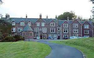
| |
| Loch Venachar Dam/Sluice House including Weir and Water Conduit | Loch Venachar, Callander | NN5979206450 | 56°13′48″N 4°15′48″W | Mid 19th-century dam and water works, built by Glasgow Corporation [13] | 4060 | 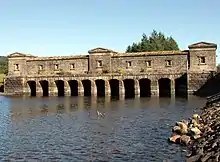
| |
| Edinample Castle | Lochearnhead | NN6017822661 | 56°22′32″N 4°15′56″W | Z-plan tower house of 1584, remodelled in the late 18th century and renovated in the late 20th century [14] | 4198 | 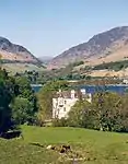
| |
| Drip Old Bridge | Craig Forth, Stirling, over River Forth | NS7701695615 | 56°08′14″N 3°58′50″W | Five-arch stone bridge built circa 1773[15] | 6725 |
| |
| Catter House | Drymen | NS4711487088 | 56°03′08″N 4°27′23″W | Late-18th-century classical house[16] | 7628 |
| |
| Gribloch House | Kippen | NS6404893484 | 56°06′53″N 4°11′17″W | 1930s country house by Basil Spence with Perry Duncan[17] | 8191 |
| |
| Doune Stable Block | Doune Park, Doune | NN7072203150 | 56°12′12″N 4°05′08″W | Quadrangular stable block with octagonal steeple dated 1809[18] | 8220 |
| |
| Old Newton House | Doune | NN7314001223 | 56°11′12″N 4°02′44″W | 16th- or 17th-century L-plan tower house[19] | 8227 |
| |
| Deanston Mill, Old Spinning Mill | Deanston | NN7155801600 | 56°11′23″N 4°04′17″W | Five-storey textile mill built 1830[20] | 8230 | 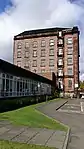
| |
| Deanston Mill, Old Weaving Shed | Deanston | NN7151901557 | 56°11′21″N 4°04′19″W | Early-19th-century vaulted building[21] | 8231 |
| |
| Lanrick Macgregor Monument | Lanrick, Doune | NN6839802928 | 56°12′03″N 4°07′22″W | Early-19th-century monument in the form of a tree trunk, topped by a classical rotunda[22] | 8244 |
| |
| Bridge of Dochart | Killin, over Falls of Dochart | NN5713632505 | 56°27′47″N 4°19′13″W | Four-arch bridge built 1760 and repaired 1831[23] | 8275 | 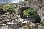
| |
| Killin Railway Viaduct | Killin, over River Dochart | NN5743532756 | 56°27′55″N 4°18′56″W | Built for the Killin Railway in 1886, the second-oldest mass-concrete railway viaduct in Britain[24] | 8281 |
| |
| Kincardine Parish Church | Kincardine-in-Menteith, Blair Drummond | NS7192098851 | 56°09′54″N 4°03′51″W | Gothic church by Richard Crichton, 1816[25] | 8431 | 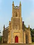
| |
| Buchanan Monument | Killearn | NS5227385975 | 56°02′38″N 4°22′23″W | Obelisk monument to George Buchanan (1506–1582), erected 1788[26] | 10389 | 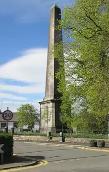
| |
| Auchenibert | Killearn | NS5308485780 | 56°02′32″N 4°21′36″W | Elizabethan-style Arts and Crafts house by Charles Rennie Mackintosh, 1906[27] | 10422 |
| |
| Gargunnock House | Gargunnock | NS7155594503 | 56°07′33″N 4°04′04″W | Late-16th-century house with 17th- and 18th-century additions[28] | 10438 | 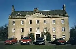
| |
| Old Leckie House | Gargunnock | NS6898094690 | 56°07′37″N 4°06′34″W | 16th-century laird's house, restored in the 1970s[29] | 10445 |
| |
| Blairlogie Castle | Blairlogie | NS8275196964 | 56°09′03″N 3°53′20″W | 16th-century tower house[30] | 10461 |
| |
| Culcreuch Castle | Fintry | NS6202587679 | 56°03′43″N 4°13′03″W | Late medieval tower house and 18th-century mansion [31] | 10467 | 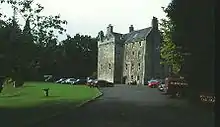
| |
| Dun Eaglais | Kippen, Station Road | NS6538194887 | 56°07′40″N 4°10′02″W | Arts and Crafts mansion of 1903 with later additions[32] | 12515 |
| |
| Milnholm Hatchery | Milnholm, Stirling | NS7841987676 | 56°03′59″N 3°57′16″W | 19th-century purpose-built fish hatchery[33] | 15275 |
| |
| Bannockburn House | Bannockburn | NS8088588881 | 56°04′40″N 3°54′55″W | 17th- or 18th-century country house[34] | 15277 |
| |
| Touch House | Touch, Stirling | NS7532892755 | 56°06′40″N 4°00′23″W | 16th-century tower house and 17th-century house, with Georgian facade by William Adam[35] | 15295 |
| |
| Auchenbowie House | Auchenbowie, Stirling | September 5, 1973 | NS7986787405 | 56°03′52″N 3°55′52″W | 17th-century house with 18th- and 19th-century alterations[36] | 15303 |
|
| Howietoun Fishery | Howietoun, Stirling | NS7851388381 | 56°04′22″N 3°57′12″W | Later 19th-century fish farm with hatchery and pools[37] | 15306 |
| |
| Hayford Mills | Cambusbarron, Stirling | NS7753092843 | 56°06′45″N 3°58′16″W | 19th-century textile mills[38] | 19117 |
| |
| Cardross House | Arnprior | NS6046397659 | 56°09′04″N 4°14′52″W | 16th-century tower house with 18th- and 19th-century additions[39] | 19708 | 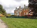
| |
| Bridge of Ardoch | Doune, over Ardoch Burn | NN7299601296 | 56°11′14″N 4°02′53″W | Single span stone bridge dated 1735[40] | 24667 | 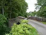
| |
| Bridge of Teith | Doune, over River Teith | NN7216801244 | 56°11′12″N 4°03′41″W | Two-arch bridge of 1535 with 19th-century widening[41] | 24668 | 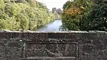
| |
| Doune Market Cross | Doune | NN7270401570 | 56°11′23″N 4°03′10″W | Mercat cross of circa 1620[42] | 24671 | 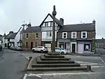
| |
| Dunblane Cathedral | Dunblane | NN7815301381 | 56°11′22″N 3°57′54″W | 13th-century church with 12th-century tower, 19th-century restoration by Robert Rowand Anderson[43] | 26361 | 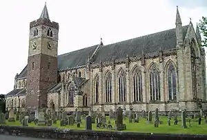
| |
| Ault Wharrie | Dunblane, Leewood Road | NN7920500909 | 56°11′08″N 3°56′52″W | Glasgow Style mansion, 1900 by George Walton[44] | 26365 |
| |
| Leighton Library | Dunblane | NN7818501292 | 56°11′19″N 3°57′52″W | 17th-century purpose-built library, the oldest in Scotland[45] | 26371 | 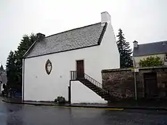
| |
| Cathedral Museum | Dunblane | NN7820901341 | 56°11′21″N 3°57′51″W | 17th-century tenement and former townhouse, altered in the 18th century [46] | 26372 | 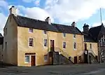
| |
| Church Of The Holy Rood | Stirling, St John Street | NS7920693710 | 56°07′15″N 3°56′40″W | 15th-century church with many later additions and alterations[47] | 41083 | 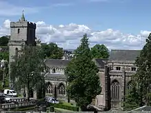
| |
| Church Of The Holy Rood Churchyard | Stirling, St John Street | NS7917593778 | 56°07′17″N 3°56′42″W | Churchyard monuments from 1579 onwards[48] | 41084 | 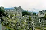
| |
| Holy Trinity Episcopal Church | Stirling, Dumbarton Road | NS7930093428 | 56°07′06″N 3°56′34″W | Gothic church by Robert Rowand Anderson, 1878[49] | 41089 | 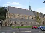
| |
| St Ninians Old Parish Kirk | Stirling, St Ninians | NS7956491677 | 56°06′09″N 3°56′16″W | Remains of 15th-century church and 18th-century steeple[50] | 41095 |
| |
| St Ninians Old Parish Kirkyard | Stirling, St Ninians | NS7959091678 | 56°06′10″N 3°56′15″W | Churchyard monuments, mainly 17th-century[51] | 41096 | 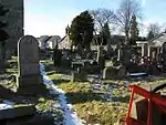
| |
| Athenaeum | Stirling, King Street | NS7956793444 | 56°07′07″N 3°56′19″W | Classical gentlemen's club by William Stirling, 1817[52] | 41100 | .jpg.webp)
| |
| Cowane's Hospital (now Guildhall) | Stirling, St John Street | NS7917393674 | 56°07′14″N 3°56′42″W | 17th-century hospital by John Mylne[53] | 41101 | 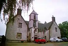
| |
| Stirling Old Town Jail (former Military Prison) | Stirling, St John Street | NS7923393615 | 56°07′12″N 3°56′39″W | Jail by Thomas Brown, 1847, converted to a museum in the 1990s[54] | 41104 | 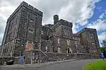
| |
| Stirling Tolbooth | Stirling, Broad Street | NS7931093694 | 56°07′14″N 3°56′34″W | Burgh tolbooth built 1705 to designs by Sir William Bruce, converted to a theatre in 2001 by Richard Murphy[55] | 41110 | 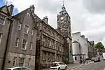
| |
| Stirling Town Wall, south boundary of Erskine Marykirk and St John Street Housing Development to Academy Street | Stirling, Back Walk | NS7945193409 | 56°07′05″N 3°56′26″W | Remnant of 16th-century town wall[56] | 41111 |
| |
| Stirling Town Wall and Bastion, boundary of Municipal Buildings, 27-33 Spittal Street and Old High School | Stirling, Back Walk | NS7943893420 | 56°07′06″N 3°56′26″W | Remnant of 16th-century town wall with beehive-shaped bastion[57] | 41112 |
| |
| Stirling Town Wall, Public Library to 16 Dumbarton Road | Stirling | NS7945193409 | 56°07′05″N 3°56′26″W | Remnant of 16th-century town wall[58] | 41113 |
| |
| Wallace Monument | Stirling, Abbey Craig | NS8092395667 | 56°08′20″N 3°55′04″W | Monumental tower by John Thomas Rochead, completed 1869[59] | 41118 | 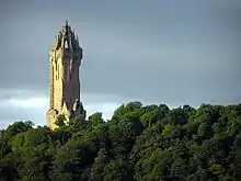
| |
| The Old Town Cemeteries | Stirling, St John Street | NS7917593778 | 56°07′17″N 3°56′42″W | 19th- and 20th-century extensions of Holy Rood Churchyard[60] | 41126 | 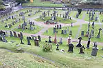
| |
| Stirling Old Bridge | Stirling | NS7971294568 | 56°07′43″N 3°56′12″W | Late-15th- or early-16th-century four-arch bridge[61] | 41129 | 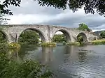
| |
| Stirling Railway Station | Stirling | NS7975893580 | 56°07′11″N 3°56′08″W | Station buildings by James Miller, 1915[62] | 41131 | 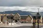
| |
| Stirling Highland Hotel, Old High School | Stirling, Academy Road | NS7934493508 | 56°07′08″N 3°56′32″W | School by J, W H & J M Hay, 1856, extended in 1905 and converted to a hotel in 1990[63] | 41133 | 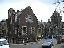
| |
| Stirling Castle, Outer Defences (1708–14) | Stirling | NS7906894007 | 56°07′24″N 3°56′49″W | Early-18th-century artillery defences[64] | 41136 | 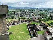
| |
| Stirling Castle, Forework (1500–1510) | Stirling | NS7904494025 | 56°07′25″N 3°56′50″W | Early-16th-century gatehouse, now much reduced[65] | 41137 | 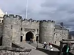
| |
| Stirling Castle Palace (1539–42) | Stirling | NS7899694035 | 56°07′25″N 3°56′53″W | Mid 16th-century Renaissance palace built for King James V[66] | 41138 | 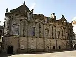
| |
| Stirling Castle, Great Hall (1503) | Stirling | NS7901794077 | 56°07′27″N 3°56′52″W | Early-16th-century hall, later used as a barracks and recently restored[67] | 41139 | 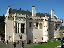
| |
| Stirling Castle Chapel Royal (1594) | Stirling | NS7898494096 | 56°07′27″N 3°56′54″W | Late-16th-century chapel[68] | 41140 | 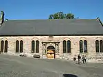
| |
| Stirling Castle, The Mint (14th-century) | Stirling | NS7903094095 | 56°07′27″N 3°56′51″W | 14th-century gatehouse with later extensions[69] | 41141 | 
| |
| Stirling Castle, Kitchen Range and Grand Battery | Stirling | NS7904994068 | 56°07′26″N 3°56′50″W | Early-18th-century vaulted kitchens, restored 1920s[70] | 41142 | 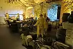
| |
| Stirling Castle, King's Old Building | Stirling | NS7896194073 | 56°07′26″N 3°56′55″W | 16th-century range, altered by Robert William Billings, 1855 [71] | 41143 | 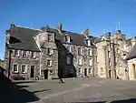
| |
| Stirling Castle, Sundial | Stirling | NS7895494116 | 56°07′28″N 3°56′56″W | 17th-century sundial[72] | 41144 |
| |
| Stirling Castle, Regimental Headquarters | Stirling | NS7906494043 | 56°07′26″N 3°56′49″W | 18th-century military building[73] | 41145 |
| |
| Erskine Of Gogar's House (Darnley's House) | Stirling, Bow Street | NS7938593684 | 56°07′14″N 3°56′30″W | Late-16th- or early-17th-century tenement house[74] | 41239 | 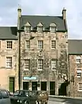
| |
| Moir of Leckie's House | Stirling, Bow Street | NS7941493678 | 56°07′14″N 3°56′28″W | Mid 17th-century town house[75] | 41240 |
| |
| East Section of James Norrie's Lodging | Stirling, Broad Street | NS7932393720 | 56°07′15″N 3°56′34″W | 17th-century town house, rebuilt in the 1950s[76] | 41246 | 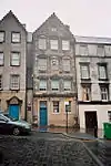
| |
| Argyll Lodging | Stirling, Castle Wynd | NS7926193808 | 56°07′18″N 3°56′37″W | 17th-century courtyard-plan town house[77] | 41255 | 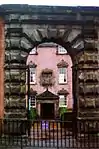
| |
| Mar's Wark | Stirling, Mar Place | NS7923293744 | 56°07′16″N 3°56′39″W | Remains of 16th-century courtyard town house[78] | 41348 | .jpg.webp)
| |
| Bruce of Auchenbowie's House | Stirling, St John Street | NS7925493676 | 56°07′14″N 3°56′37″W | 16th-century town house with later alterations[79] | 41464 |
| |
| John Cowane's House | Stirling, St Mary's Wynd | NS7932693851 | 56°07′20″N 3°56′34″W | Remains of 17th-century town house[80] | 41466 |
| |
| Glengarry Lodge or Darrow Lodging | Stirling, Spittal Street | NS7938093599 | 56°07′11″N 3°56′30″W | 17th-century town house, rebuilt in the 1950s[81] | 41484 |
| |
| Deanston Mills, Weir | Deanston | NN7030902667 | 56°11′56″N 4°05′31″W | The largest weir of its type in Scotland, built circa 1827 to power textile mill[82] | 47650 |
| |
| Bannockburn Rotunda, Memorial Cairn, Flagpole and Statue of King Robert I | Bannockburn, Borestone Brae | NS7948890691 | 56°05′38″N 3°56′19″W | Battle of Bannockburn (1314) battlefield memorial with statue by Charles d'Orville Pilkington Jackson[83] | 49860 | 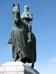
| |
| Cayzer Family Private Cemetery, Sundial | Gartmore | NS5208897164 | 56°08′39″N 4°22′56″W | 17th-century sandstone obelisk sundial, one of only 25 to survive in Scotland[84] | 50406 |
|
See also
- Category:Listed buildings in Stirling (council area)
- Scheduled monuments in Stirling (council area)
Notes
- Sometimes known as OSGB36, the grid reference (where provided) is based on the British national grid reference system used by the Ordnance Survey.
• "Guide to National Grid". Ordnance Survey. Retrieved 2007-12-12.
• "Get-a-map". Ordnance Survey. Retrieved 2007-12-17. - Historic Environment Scotland assign a unique alphanumeric identifier to each designated site in Scotland, for listed buildings this always begins with "LB", for example "LB12345".
References
- Guide to the Protection of Scotland's Listed Buildings (PDF). Historic Scotland. 2009. p. 4. ISBN 978-1-84917-013-0. Retrieved 2010-05-05.
- "What is Listing?". Historic Scotland. Retrieved 2010-05-05.
- Scottish Historic Environment Policy (PDF). Historic Scotland. October 2008. pp. 24–25. ISBN 978-1-84917-002-4. Retrieved 2010-05-05.
- Guide to the Protection of Scotland’s Listed Buildings, p. 17.
- "Lecropt Church: Listed Building Report". Historic Scotland.
- "Keir, Keir Home Farm: Listed Building Report". Historic Scotland.
- "Keir, South Lodge: Listed Building Report". Historic Scotland.
- "Keir House: Listed Building Report". Historic Scotland.
- "Auchentroig, Old Auchentroig: Listed Building Report". Historic Scotland.
- "Queen Victoria School, Dunblane: Listed Building Report". Historic Scotland.
- "Memorial Chapel, Dunblane: Listed Building Report". Historic Scotland.
- "Cromlix House, Sundial and Flanking Pair of Gatepiers: Listed Building Report". Historic Scotland.
- "Loch Venachar Dam/Sluice House Including Weir And Water Conduit (Formerly Glasgow Corporation Water Works): Listed Building Report". Historic Scotland.
- "Edinample Castle With Ancillary Building, Bothy And Garden Walls: Listed Building Report". Historic Scotland.
- "Drip Old Bridge Over River Forth: Listed Building Report". Historic Scotland.
- "Catter House: Listed Building Report". Historic Scotland.
- "Gribloch House And Swimming Pool: Listed Building Report". Historic Scotland.
- "Doune Stable Block: Listed Building Report". Historic Scotland.
- "Old Newton House, Doune: Listed Building Report". Historic Scotland.
- "Deanston Mill, Old Spinning Mill: Listed Building Report". Historic Scotland.
- "Deanston Mill, Old Weaving Shed: Listed Building Report". Historic Scotland.
- "Lanrick Macgregor Monument: Listed Building Report". Historic Scotland.
- "Killin, Bridge Of Dochart Over Falls Of Dochart: Listed Building Report". Historic Scotland.
- "Killin, Railway Viaduct Over River Dochart: Listed Building Report". Historic Scotland.
- "Parish Church, Kincardine: Listed Building Report". Historic Scotland.
- "Buchanan Monument: Listed Building Report". Historic Scotland.
- "Killearn, Auchenibert With Terraced Garden: Listed Building Report". Historic Scotland.
- "Gargunnock House: Listed Building Report". Historic Scotland.
- "Old Leckie House: Listed Building Report". Historic Scotland.
- "Blairlogie Castle: Listed Building Report". Historic Scotland.
- "Culcreuch Castle: Listed Building Report". Historic Scotland.
- "Kippen, Station Road, Dun Eaglais, Including Designed Garden: Listed Building Report". Historic Scotland.
- "Milnholm Hatchery: Listed Building Report". Historic Scotland.
- "Bannockburn House: Listed Building Report". Historic Scotland.
- "Touch House (Mrs Buchanan): Listed Building Report". Historic Scotland.
- "Auchenbowie House: Listed Building Report". Historic Scotland.
- "Howietoun Fishery: Listed Building Report". Historic Scotland.
- "Cambusbarron, Hayford Mills: Listed Building Report". Historic Scotland.
- "Cardross House: Listed Building Report". Historic Scotland.
- "Bridge Of Ardoch (Old): Listed Building Report". Historic Scotland.
- "Bridge Of Teith: Listed Building Report". Historic Scotland.
- "Market Cross The Cross: Listed Building Report". Historic Scotland.
- "Cathedral Square, Dunblane Cathedral (Cathedral Church Of St Blaan And St Laurence Including Churchyard, Boundary Wall And Riccarton's Stile): Listed Building Report". Historic Scotland.
- "Leewood Road, Ault Wharrie Including Summer House, Walled Garden, Terraced Garden Wall, Gate Lodge, Boundary Wall And Gatepiers: Listed Building Report". Historic Scotland.
- "The Cross, Leighton Library: Listed Building Report". Historic Scotland.
- "The Cross, Cathedral Museum, Including Residential Properties To South Adjoining Burgh Chambers And Well To Rear: Listed Building Report". Historic Scotland.
- "Church Of The Holy Rood St John Street: Listed Building Report". Historic Scotland.
- "Church Of The Holy-Rood Churchyard: Listed Building Report". Historic Scotland.
- "Holy Trinity Episcopal Church 26 Dumbarton Road: Listed Building Report". Historic Scotland.
- "St Ninians Old Parish Kirk Kirk Wynd: Listed Building Report". Historic Scotland.
- "St. Ninians Old Parish Kirk Kirkyard: Listed Building Report". Historic Scotland.
- "2 Spittal Street And 65, 67 King Street, Athenaeum: Listed Building Report". Historic Scotland.
- "Cowane's Hospital (Now Guildhall) Including Adjoining Terrace To Bowling Green 47, 49 St John Street And Lampstands: Listed Building Report". Historic Scotland.
- "31 St John Street, Stirling Old Town Jail (Former Military Prison) With Boundary Walls, Gatepiers And Gates: Listed Building Report". Historic Scotland.
- "35, 37 Broad Street, Jail Wynd And 32 St John Street, Tolbooth: Listed Building Report". Historic Scotland.
- "Back Walk, Town Wall, South Boundary Of Erskine Marykirk And St John Street Housing Development To Academy Street: Listed Building Report". Historic Scotland.
- "Back Walk, Town Wall And Bastion, Boundary Of Municipal Buildings, 27-33 (Odd Nos) Spittal Street And Old High School: Listed Building Report". Historic Scotland.
- "Town Wall Public Library To 16 Dumbarton Road Being S Boundary Of 16 Dumbarton Road, 2, 4 Back Walk, 51 King Street 15 And 19 Corn Exchange Road: Listed Building Report". Historic Scotland.
- "Wallace Monument Abbey Craig: Listed Building Report". Historic Scotland.
- "The Old Town Cemeteries: Listed Building Report". Historic Scotland.
- "Stirling, Old Bridge: Listed Building Report". Historic Scotland.
- "Stirling Railway Station, Station Road, With North And Middle Signal Boxes And Associated Semaphore Signals: Listed Building Report". Historic Scotland.
- "Academy Road, Stirling Highland Hotel, Old High School: Listed Building Report". Historic Scotland.
- "Stirling Castle (Comprising): Outer Defences The Counter Guard (1708–14): Listed Building Report". Historic Scotland.
- "Stirling Castle Forework (1500–1510): Listed Building Report". Historic Scotland.
- "Stirling Castle Palace (1539–42): Listed Building Report". Historic Scotland.
- "Stirling Castle Great Hall (1503): Listed Building Report". Historic Scotland.
- "Stirling Castle Chapel Royal (1594): Listed Building Report". Historic Scotland.
- "Stirling Castle The Mint (14th-century): Listed Building Report". Historic Scotland.
- "Stirling Castle Kitchen Range And Grand Battery: Listed Building Report". Historic Scotland.
- "Stirling Castle The King's Old Building: Listed Building Report". Historic Scotland.
- "Stirling Castle Sundial: Listed Building Report". Historic Scotland.
- "Stirling Castle Regimental Headquarters: Listed Building Report". Historic Scotland.
- "16 (Part) And 18 Bow Street, Erskine Of Gogar's House (Commonly Known As Darnley's House): Listed Building Report". Historic Scotland.
- "16 Bow Street (Part, Within Close), Moir Of Leckie's House: Listed Building Report". Historic Scotland.
- "16 Broad Street, East Section Of James Norrie's Lodging: Listed Building Report". Historic Scotland.
- "Castle Wynd Argyll Lodging (Including Garden Wall.) Now Youth Hostel.: Listed Building Report". Historic Scotland.
- "Mar Place Mar's Wark: Listed Building Report". Historic Scotland.
- "39 And 41 St John Street, Bruce Of Auchenbowie's House: Listed Building Report". Historic Scotland.
- "St Mary's Wynd John Cowane's House: Listed Building Report". Historic Scotland.
- "56 Spittal Street, Glengarry Lodge Or Darrow Lodging: Listed Building Report". Historic Scotland.
- "Deanston Mills, Weir: Listed Building Report". Historic Scotland.
- "Bannockburn, Rotunda, Memorial Cairn, Flagpole And Statue Of King Robert I: Listed Building Report". Historic Scotland.
- "Gartmore, Cayzer Family Private Cemetery, Sundial: Listed Building Report". Historic Scotland.
External links
![]() Media related to Category A listed buildings in Stirling council area at Wikimedia Commons
Media related to Category A listed buildings in Stirling council area at Wikimedia Commons