List of Category A listed buildings in Shetland
This is a list of Category A listed buildings in Shetland, Scotland.
In Scotland, the term listed building refers to a building or other structure officially designated as being of "special architectural or historic interest".[1] Category A structures are those considered to be buildings of "national or international importance, either architecturally or historically".[1] Listing was begun by a provision in the Town and Country Planning (Scotland) Act 1947, and the current legislative basis for listing is the Planning (Listed Buildings and Conservation Areas) (Scotland) Act 1997.[1] The authority for listing rests with Historic Environment Scotland, an executive agency of the Scottish Government, which inherited this role from the Scottish Development Department in 1991. Once listed, severe restrictions are imposed on the modifications allowed to a building's structure or its fittings. Listed building consent must be obtained from local authorities prior to any alteration to such a structure. There are approximately 47,000 listed buildings in Scotland, of which around 8 percent (some 3,800) are Category A.[1]
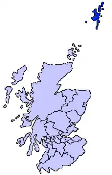
The council area of Shetland comprises an archipelago of around 100 islands, including 15 inhabited islands with a total population of around 20,000. There are 11 Category A listed buildings on the islands, representing a range of building dates and types. Two lighthouses merit Category A listing: Sumburgh Head Lighthouse is described as "one of Scotland's finest surviving pieces of early 19th century architecture";[2] while the Muckle Flugga Lighthouse is Britain's most northerly building. Other functional buildings include the grain mill at Quendale, and the waterfront warehouses at The Lodberrie in Lerwick, said to be "the most photographed building in Shetland."[3] There are a number of haas, or laird's houses, of the 17th and 18th centuries. The 17th-century Fort Charlotte was burnt by the Dutch in 1673, and was rebuilt during the American Revolutionary War (1775–1783), though it saw no action in that conflict.[4]
Listed buildings
| Name | Location | Date Listed | Grid Ref. [note 1] | Geo-coordinates | Notes | LB Number [note 2] | Image |
|---|---|---|---|---|---|---|---|
| Quendale Mill | Quendale, Mainland | 18/10/1977 | HU3710513221 | 59°54′09″N 1°20′19″W | 19th-century grain mill, including dam, steading, walls, and bridge | 5417 | 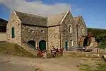
|
| Sumburgh Head Lighthouse | Sumburgh Head, Mainland | 18/10/1977 | HU4072307872 | 59°51′15″N 1°16′30″W | 19th-century lighthouse, designed by Robert Stevenson, including ancillary buildings | 5442 | 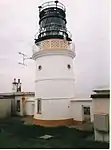
|
| Gardie House | Bressay | 13/8/1971 | HU4877242061 | 60°09′36″N 1°07′23″W | 18th-century country house with later additions | 5880 | 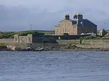
|
| Belmont House | Belmont, Unst | 13/8/1971 | HP5650601022 | 60°41′18″N 0°58′02″W | 18th-century Georgian house, including farm cottage and steading | 17474 | 
|
| North Unst Lighthouse | Muckle Flugga, north of Unst | 13/8/1971 | HP6066619679 | 60°51′19″N 0°53′07″W | 19th-century lighthouse, designed by David and Thomas Stevenson | 17479 | 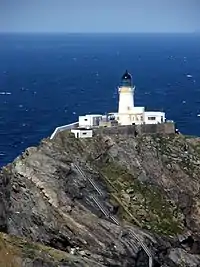
|
| Old Haa Of Scalloway | New Street, Scalloway | 8/11/1974 | HU4037839369 | 60°08′13″N 1°16′30″W | 18th-century laird's house | 18558 | 
|
| North Haa (West Sandwick House) | West Sandwick, Yell | 13/8/1971 | HU4455787973 | 60°34′22″N 1°11′20″W | 17th-century laird's house with later alterations | 18648 | .jpg.webp)
|
| Haa of Sand | Sand, Mainland | 13/8/1971 | HU3443547118 | 60°12′25″N 1°22′50″W | 18th-century classical laird's house | 18693 | .jpg.webp)
|
| The Lodberrie | 20 Commercial Street, Lerwick | 8/12/1971 | HU4789441244 | 60°09′10″N 1°08′21″W | Later 18th-century house and stores on sea wall | 37242 | 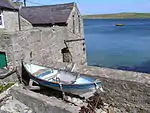
|
| Fort Charlotte | Commercial Road And Harbour Street, Lerwick | 8/12/1971 | HU4755241516 | 60°09′19″N 1°08′43″W | 17th-century fort, rebuilt in 1781 | 37255 | 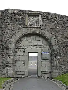
|
| Brough Lodge | Fetlar | 30/3/1998 | HU5789992522 | 60°36′43″N 0°56′39″W | 19th-century picturesque Gothic Revival lodge house | 45269 | 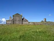
|
See also
Notes
- Sometimes known as OSGB36, the grid reference (where provided) is based on the British national grid reference system used by the Ordnance Survey.
• "Guide to National Grid". Ordnance Survey. Retrieved 12 December 2007.
• "Get-a-map". Ordnance Survey. Retrieved 17 December 2007. - Historic Environment Scotland assign a unique alphanumeric identifier to each designated site in Scotland, for listed buildings this always begins with "LB", for example "LB12345".
References
- Scotland’s Listed Buildings 2016. Historic Environment Scotland. 2016. Retrieved 20 February 2017.
- "Sumburgh Head Lighthouse, Listed Building Report". Historic Environment Scotland. Retrieved 20 February 2017.
- "The Lodberrie, Listed Building Report". Historic Environment Scotland. Retrieved 20 February 2017.
- "Fort Charlotte, Listed Building Report". Historic Environment Scotland. Retrieved 20 February 2017.
External links
![]() Media related to Category A listed buildings in the Shetland Islands at Wikimedia Commons
Media related to Category A listed buildings in the Shetland Islands at Wikimedia Commons