List of Category A listed buildings in Fife
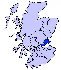
This is a list of Category A listed buildings in the Fife council area in east-central Scotland.
In Scotland, the term listed building refers to a building or other structure officially designated as being of "special architectural or historic interest".[1] Category A structures are those considered to be "buildings of national or international importance, either architectural or historic, or fine little-altered examples of some particular period, style or building type."[2] Listing was begun by a provision in the Town and Country Planning (Scotland) Act 1947, and the current legislative basis for listing is the Planning (Listed Buildings and Conservation Areas) (Scotland) Act 1997.[3] The authority for listing rests with Historic Scotland, an executive agency of the Scottish Government, which inherited this role from the Scottish Development Department in 1991. Once listed, severe restrictions are imposed on the modifications allowed to a building's structure or its fittings. Listed building consent must be obtained from local authorities prior to any alteration to such a structure.[3] There are approximately 47,400 listed buildings in Scotland, of which around 8% (some 3,800) are Category A.[4]
The council area of Fife covers 1,325 square kilometres (512 sq mi), and has a population of around 361,900. There are 200 Category A listed buildings in the area, as of February 2017.
Listed buildings
| Name | Location | Date Listed | Grid Ref. [note 1] | Geo-coordinates | Notes | LB Number [note 2] | Image |
|---|---|---|---|---|---|---|---|
| Gibliston House | Arncroach | NO4980604979 | 56°14′05″N 2°48′41″W | 1820 classical villa, extensions by Sir Robert Lorimer[5] | 155 | 
| |
| The King's Cellar | Limekilns, Academy Square | NT0762983443 | 56°02′06″N 3°29′02″W | 16th-century storehouse, possibly incorporating material from 1362[6] | 1643 | 
| |
| Creich Castle Doocot | Creich | NO3279821289 | 56°22′45″N 3°05′23″W | Dovecote dated 1723[7] | 2173 | 
| |
| Bishop Bridge | Ceres, High Street, over Ceres Burn | NO4001511429 | 56°17′29″N 2°58′14″W | 17th-century single-arch stone bridge[8] | 2366 | 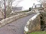
| |
| St John's Masonic Lodge | Ceres | NO4003211419 | 56°17′29″N 2°58′13″W | Mid 18th-century Masonic lodge[9] | 2368 | .jpg.webp)
| |
| Southern outbuilding of Brand's Hotel | Ceres, High Street | NO4001611479 | 56°17′31″N 2°58′14″W | 18th-century mill, later a beer store[10] | 2393 | .jpg.webp)
| |
| Fife Folk Museum (Central And North Fife Preservation Society) | Ceres, High Street | NO4002911468 | 56°17′31″N 2°58′14″W | 17th-century cottages and weigh house, now a museum[11] | 2394 | .jpg.webp)
| |
| Balcaskie House | Near St Monans | NO5246903579 | 56°13′21″N 2°46′05″W | 16th-century house, enlarged by Sir William Bruce for himself in 1688[12] | 2503 | 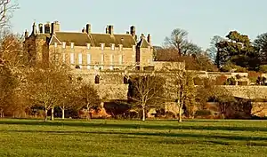
| |
| Balcaskie House, Terraced Garden | Near St Monans | NO5249803508 | 56°13′18″N 2°46′03″W | 17th-century Italianate gardens laid out by Sir William Bruce[13] | 2504 | 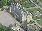
| |
| Balcaskie House, east gatepiers and twin dovecots | Near St Monans | NO5303103887 | 56°13′31″N 2°45′33″W | 18th-century gate piers and dovecotes[14] | 2506 |
| |
| Kellie Castle | Arncroach | NO5201005239 | 56°14′14″N 2°46′33″W | 14th-century castle with later rebuilding and extensions[15] | 2519 | 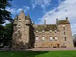
| |
| Balmerino Abbey, barn | Balmerino | NO3577224720 | 56°24′37″N 3°02′33″W | 15th-century barn[16] | 2548 |
| |
| Dairsie Bridge | Dairsie, over River Eden | NO4157716102 | 56°20′01″N 2°56′47″W | Late mediaeval three-arch stone bridge[17] | 2607 | .jpg.webp)
| |
| Dairsie Old Church (St Mary's) | Dairsie | NO4140016090 | 56°20′01″N 2°56′58″W | 17th-century Gothic former church[18] | 2610 | 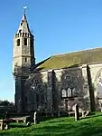
| |
| Hill of Tarvit House | Near Cupar | NO3789411860 | 56°17′42″N 3°00′18″W | late-17th-century house remodelled by Sir Robert Lorimer in 1907[19] | 2628 | 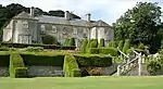
| |
| Tarvit Farm | Near Cupar | NO3854513962 | 56°18′51″N 2°59′42″W | Steading of circa 1800, with central tower and spire[20] | 2674 | 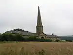
| |
| Benarty House | Near Ballingry | NT1572496481 | 56°09′13″N 3°21′30″W | Earlier 19th-century mansion[21] | 3321 |
| |
| Benarty Steading | Near Ballingry | NT1566996574 | 56°09′16″N 3°21′33″W | Farmstead of circa 1840[22] | 3322 |
| |
| Dunimarle Castle | Culross | NS9772685902 | 56°03′18″N 3°38′38″W | 1840 castlellated house by R. and R. Dickson[23] | 3349 | .jpg.webp)
| |
| Inchcolm Abbey | Inchcolm | NT1897382656 | 56°01′48″N 3°18′06″W | Remains of Augustinian monastery dating from the 12th to the 16th centuries[24] | 3573 | ||
| The Murrell | Near Aberdour | NT1876486685 | 56°03′58″N 3°18′23″W | 1908 Arts and Crafts country house by Francis William Deas[25] | 3598 |
| |
| Aberdour Kirk, St Fillan's (Church Of Scotland) | Aberdour, Hawkcraig Road | NT1932085468 | 56°03′19″N 3°17′49″W | 12th-century church, restored 1926[26] | 3608 | 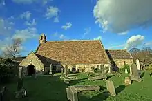
| |
| Aberdour Castle walled garden with sundial | Aberdour | NT1932385518 | 56°03′20″N 3°17′49″W | 17th-century walled garden[27] | 3610 | 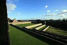
| |
| Aberdour Castle Dovecot | Aberdour | NT1930785400 | 56°03′17″N 3°17′50″W | 16th-century beehive dovecote[28] | 3611 | 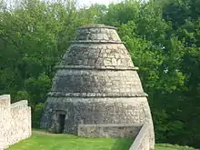
| |
| Seabank House | Aberdour, Shore Road | NT1925585024 | 56°03′04″N 3°17′53″W | Classical villa by Thomas Hamilton, 1831[29] | 3632 |
| |
| Aberdour House | Aberdour | NT1915085376 | 56°03′16″N 3°17′59″W | 17th-century house with early-18th-century addition[30] | 3636 |
| |
| Aberdour Castle Sundial (formerly at Aberdour House) | Aberdour | NT1916785371 | 56°03′16″N 3°17′58″W | 16th-century stone sundial[31] | 3637 | 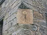
| |
| Donibristle House | Dalgety Bay | NT1600782863 | 56°01′53″N 3°20′58″W | 18th-century service wings by Alexander McGill, main house demolished[32] | 3647 | 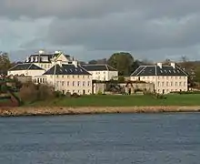
| |
| Donibristle Chapel | Dalgety Bay | NT1582582784 | 56°01′50″N 3°21′08″W | Mortuary chapel of Earls of Moray by Alexander McGill, 1731[33] | 3650 | 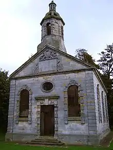
| |
| Fordell Castle | Near Dalgety Bay | NT1469685388 | 56°03′13″N 3°22′16″W | 16th-century fortified house[34] | 3652 | 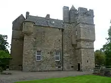
| |
| Fordell Chapel | Near Dalgety Bay | NT1465585350 | 56°03′12″N 3°22′19″W | Mortuary chapel of Hendersons of Fordell, dated 1650[35] | 3653 |
| |
| St. Bridget's Church | Dalgety Bay | NT1695683795 | 56°02′23″N 3°20′04″W | Roofless pre-Reformation church[36] | 3667 | 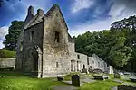
| |
| Limekilns | Charlestown, Harbour Road | NT0642283561 | 56°02′09″N 3°30′12″W | Range of fourteen 18th-century lime kilns[37] | 3741 | .jpg.webp)
| |
| Broomhall | Limekilns | NT0768583683 | 56°02′14″N 3°28′59″W | Neo-Classical mansion by Thomas Harrison, 1796[38] | 3745 |
| |
| Pitfirrane Castle | Crossford | NT0633286113 | 56°03′31″N 3°30′21″W | 16th-century L-plan tower house[39] | 3759 | .jpg.webp)
| |
| Logie House | Crossford | NT0781286167 | 56°03′34″N 3°28′55″W | 16th-century tower house with 19th-century classical remodelling[40] | 3776 |
| |
| Logie House, Steading | Crossford | NT0763086394 | 56°03′41″N 3°29′06″W | Late-18th-century steading and granary[41] | 3777 |
| |
| Greenside Farm Steading | Near Ceres | NO3931407354 | 56°15′17″N 2°58′52″W | 18th-century farm buildings[42] | 4302 | 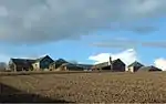
| |
| Wormiston, Doocot | Near Crail | NO6100609603 | 56°16′38″N 2°37′53″W | Early-17th-century rectangular dovecote[43] | 4329 | 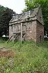
| |
| Aberdour Castle | Aberdour | NT1924985449 | 56°03′18″N 3°17′53″W | Buildings dating from 12th to 17th centuries, partly ruined[44] | 6421 | 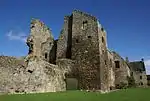
| |
| East Lodge and gates | Aberdour, High Street | NT1888485196 | 56°03′10″N 3°18′14″W | Former lodge of Donibristle Estate by J Maitland and Wardrop, 1870[45] | 6632 | .jpg.webp)
| |
| Charleton House | Colinsburgh | NO4596703892 | 56°13′28″N 2°52′23″W | 18th-century country house[46] | 8581 | 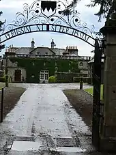
| |
| Balcarres House | Colinsburgh | NO4740804408 | 56°13′45″N 2°50′59″W | 16th-century Z-plan tower house with 19th-century extensions by William Burn and David Bryce, and 18th-century dower house[47] | 8625 | 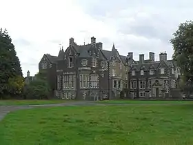
| |
| Balcarres House, sundial | Colinsburgh | NO4737704350 | 56°13′44″N 2°51′01″W | 17th-century sundial from Leuchars Castle[48] | 8627 | .jpg.webp)
| |
| House of Falkland (St Ninian's RC School) | Falkland | NO2423807405 | 56°15′11″N 3°13′28″W | Jacobean mansion by William Burn, 1844[49] | 8763 | .jpg.webp)
| |
| Randerston Farm House | Kingsbarns | NO6086310842 | 56°17′18″N 2°38′02″W | Late-16th-century laird's house[50] | 8796 |
| |
| Falkland Palace | Falkland | NO2534507454 | 56°15′13″N 3°12′23″W | Former Royal palace, mostly built in the first half of the 16th century[51] | 8798 | .JPG.webp)
| |
| Falkland Palace, Royal Stables and Tennis Court or Caichpule | Falkland | NO2538407645 | 56°15′20″N 3°12′21″W | 16th-century ancillary buildings[52] | 8800 | 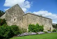
| |
| Kilmany Parish Kirk | Kilmany | NO3882321749 | 56°23′03″N 2°59′32″W | 18th-century church[53] | 8826 | .jpg.webp)
| |
| Parish Kirk of St Athernase | Leuchars, Schoolhill | NO4554221394 | 56°22′54″N 2°53′00″W | 12th-century Romanesque church[54] | 8842 | 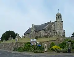
| |
| Leuchars Castle, Doocot | Leuchars | NO4521421916 | 56°23′11″N 2°53′20″W | 17th-century round dovecote[55] | 8851 | 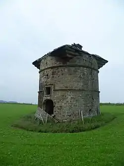
| |
| Earlshall Castle | Leuchars | NO4647521083 | 56°22′44″N 2°52′06″W | 16th-century tower house, extended in the 17th century[56] | 8852 | 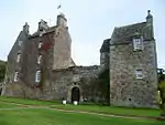
| |
| Earlshall Doocot | Leuchars | NO4646021001 | 56°22′42″N 2°52′07″W | late-16th-century rectangular dovecote[57] | 8853 | .jpg.webp)
| |
| Pitcullo Castle | Near Balmullo | NO4135019280 | 56°21′44″N 2°57′03″W | Late-16th-century L-plan tower house, extended in the 17th century[58] | 8857 | 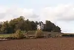
| |
| Guardbridge (Old) | Guardbridge, over River Eden | NO4518818877 | 56°21′33″N 2°53′19″W | 16th-century six-arch stone bridge[59] | 8861 | 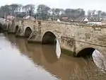
| |
| Vicarsford Cemetery Chapel | Leuchars | 17/10/1973 | NO4387025719 | 56°25′13″N 2°54′41″W | Late 19th-century chapel in 13th-century French Gothic style[60] | 8863 | 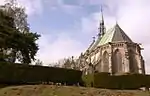
|
| West Pitkierie Dovecot | Near Anstruther | NO5551005549 | 56°14′25″N 2°43′10″W | Later 18th-century octagonal dovecote[61] | 8979 | 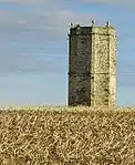
| |
| Elie House (Convent Of St Marty Reparatrice) | Elie | NO4954400762 | 56°11′48″N 2°48′53″W | 17th-century mansion with 18th- and 19th-century additions[62] | 9000 | 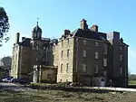
| |
| Scotscraig House | Tayport | NO4446428224 | 56°26′34″N 2°54′09″W | 17th-century arched gateway[63] | 9004 |
| |
| Lathrisk House | Freuchie | NO2732208468 | 56°15′47″N 3°10′30″W | 18th-century classical mansion[64] | 9042 |
| |
| Raith Estate, Raith House | Kirkcaldy | NT2562591768 | 56°06′46″N 3°11′51″W | Palladian mansion by James Smith, 1694[65] | 9681 |
| |
| Raith Estate, Stable Court (Home Farm) | Kirkcaldy | NT2551891855 | 56°06′49″N 3°11′58″W | 18th-century stables, possibly by James Playfair[66] | 9682 |
| |
| Leslie House | Leslie | NO2596801833 | 56°12′12″N 3°11′42″W | 17th-century classical house by John Mylne and William Bruce[67] | 9693 | 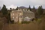
| |
| Forth Bridge[note 3] | North Queensferry, across the Firth of Forth | NT1355479252 | 55°59′54″N 3°23′15″W[note 3]) | Cantilevered railway viaduct, designed by Sir John Fowler and Sir Benjamin Baker, and completed in 1890[68] | 9977 | .jpg.webp)
| |
| North Queensferry, Town Pier | North Queensferry | NT1309680274 | 56°00′27″N 3°23′43″W | Pier built by John Rennie, 1813, and extended by Thomas Telford, 1834[69] | 9978 | 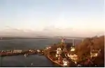
| |
| Old Duloch House | Duloch | NT1341285475 | 56°03′15″N 3°23′31″W | 18th-century classical mansion[70] | 9981 |
| |
| North Queensferry, Pierhead, Lantern Tower | North Queensferry | NT1312980359 | 56°00′30″N 3°23′41″W | Small hexagonal lighthouse by John Rennie, circa 1812[71] | 9998 |
| |
| Melville House | Monimail, Ladybank | NO2989313801 | 56°18′41″N 3°08′05″W | Late-17th-century country house by James Smith[72] | 15448 | 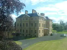
| |
| Cunnoquhie House | Letham | NO3131215227 | 56°19′28″N 3°06′44″W | Late-18th- or early-19th-century classical mansion[73] | 15469 | .jpg.webp)
| |
| Over Rankeilour House | Letham | NO3285313569 | 56°18′35″N 3°05′13″W | Late-18th-century classical mansion[74] | 15486 | .jpg.webp)
| |
| Monimail Tower or Palace (also known as Cardinal Beaton's Tower) | Monimail, Ladybank | NO2983914092 | 56°18′50″N 3°08′09″W | 16th-century tower house[75] | 15498 | 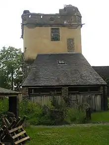
| |
| St Monans Church and Churchyard | St Monans | NO5226501443 | 56°12′11″N 2°46′16″W | 14th-century church with 19th- and 20th-century alterations[76] | 15558 | 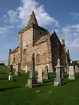
| |
| Pitcairlie House | Near Lindores | NO2385514992 | 56°19′16″N 3°13′58″W | 16th-century tower house with 18th-century extensions[77] | 15565 | _(14759208966).jpg.webp)
| |
| Town Hall Steeple | Strathmiglo, High Street | NO2149110241 | 56°16′41″N 3°16′10″W | 18th-century steeple attached to later town hall[78] | 15754 | 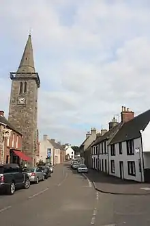
| |
| Pitlour House | Strathmiglo | NO2091511155 | 56°17′10″N 3°16′45″W | 18th-century house by Robert Mylne[79] | 15768 |
| |
| Strathtyrum House | Strathtyrum, St Andrews | NO4901117245 | 56°20′41″N 2°49′35″W | 18th-century country house[80] | 15817 |
| |
| Kenly Green House | Boarhills, Kingsbarns | NO5682013768 | 56°18′52″N 2°41′59″W | Late-18th-century country house[81] | 15841 |
| |
| Tulliallan Castle (Scottish Police College) | Kincardine | NS9362188072 | 56°04′25″N 3°42′38″W | Castellated Gothic mansion, 1820, by William Atkinson[82] | 16585 | 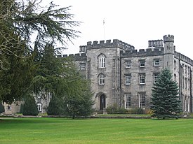
| |
| Balgonie Castle | Milton of Balgonie | NO3125000692 | 56°11′38″N 3°06′34″W | Late-14th- and early-15th-century courtyard castle, with later additions[83] | 16664 | 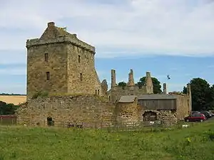
| |
| Balbirnie House | Glenrothes | NO2901102479 | 56°12′34″N 3°08′46″W | Greek revival house by Richard Crichton, 1817[84] | 16687 | 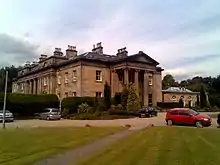
| |
| Durie House | Leven | NO3732402598 | 56°12′43″N 3°00′43″W | Classical mansion of 1762[85] | 16699 | 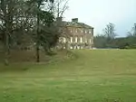
| |
| Wemyss Castle | West Wemyss | NT3293095150 | 56°08′40″N 3°04′52″W | Late-15th-century house with many later additions[86] | 16709 | 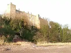
| |
| Cunnoquhie former Stable Block | Letham | NO3124515234 | 56°19′28″N 3°06′48″W | Early-19th-century classical stable block with clock tower[87] | 19749 |
| |
| 6-9 (inclusive Nos) Broomhill | Burntisland | NT2319185931 | 56°03′36″N 3°14′06″W | Gothic semi-detached houses by F T Pilkington, dated 1858[88] | 22752 |
| |
| Burntisland Parish Church | Burntisland, East Leven Street | NT2335085712 | 56°03′29″N 3°13′57″W | Late-16th-century church, the first post-Reformation church built in Scotland[89] | 22777 | 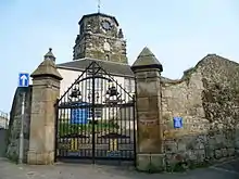
| |
| Crail Parish Church | Crail, Marketgate | NO6133907976 | 56°15′46″N 2°37′33″W | Oldest parts c. 1160, tower c. 1200, later rebuilding[90] | 23244 | 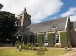
| |
| Crail Parish Churchyard Walls and Gravestones | Crail, Marketgate | NO6136607986 | 56°15′46″N 2°37′31″W | Churchyard with mural monuments dating from 16th and 17th century[91] | 23245 | .jpg.webp)
| |
| Kirkmay House Hotel | Crail, Marketgate | NO6132907906 | 56°15′43″N 2°37′33″W | Classical town house of 1817[92] | 23251 | 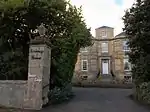
| |
| Friar's Court | Crail, Marketgate | NO6134107865 | 56°15′42″N 2°37′32″W | 17th-century town house[93] | 23253 | 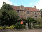
| |
| The Tolbooth and Town Hall | Crail, Marketgate | NO6131507773 | 56°15′39″N 2°37′34″W | 16th-century tolbooth tower and 19th-century town hall[94] | 23287 | 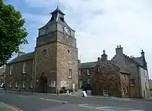
| |
| The Golf Hotel | Crail, High Street | NO6128207739 | 56°15′38″N 2°37′36″W | Large 18th-century town house[95] | 23290 | 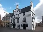
| |
| 35 Shoregate (The Custom House) | Crail | NO6118907428 | 56°15′28″N 2°37′41″W | Late-17th-century warehouse[96] | 23378 | 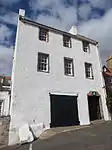
| |
| Crail Harbour | Crail | NO6115907405 | 56°15′27″N 2°37′43″W | Medieval harbour with later rebuilding, west pier by Robert Stevenson, 1828[97] | 23398 | 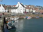
| |
| Priory Doocot, off Nethergate | Crail | NO6159507823 | 56°15′41″N 2°37′18″W | 16th-century circular dovecote[98] | 23445 | 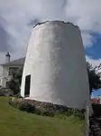
| |
| Culross Abbey Church | Culross | NS9888486246 | 56°03′30″N 3°37′31″W | 13th-century abbey church with many later additions[99] | 23960 | 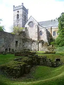
| |
| Culross Abbey House | Culross | NS9894286251 | 56°03′30″N 3°37′28″W | Country house built 1608, with later developments, remodelled 1952 by Robert Hurd & Partners[100] | 23964 | .jpg.webp)
| |
| Culross Abbey House, Garden House | Culross | NS9910186259 | 56°03′31″N 3°37′19″W | 17th-century garden building[101] | 23965 |
| |
| West Kirk Churchyard | Culross | NS9795386485 | 56°03′37″N 3°38′25″W | Churchyard and boundary walls[102] | 23969 | 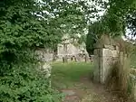
| |
| Culross Palace | Culross | Not listed | NS9851585951 | 56°03′20″N 3°37′52″W | Late-16th-century T-plan town house[103] | 23983 | 
|
| Culross Town House | Culross | NS9857285916 | 56°03′19″N 3°37′49″W | 17th-century town hall with 18th-century clock tower[104] | 23994 | 
| |
| Culross Mercat Cross | Culross | NS9868385948 | 56°03′20″N 3°37′42″W | 16th-century market cross, shaft replaced 1902[105] | 24000 | 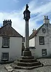
| |
| Bishop Leighton's House | Culross, 5 Mid Causeway | NS9866685917 | 56°03′19″N 3°37′43″W | Early-17th-century town house[106] | 24006 |
| |
| The Study | Culross | NS9867585962 | 56°03′21″N 3°37′43″W | Early-17th-century town house[107] | 24045 | .jpg.webp)
| |
| Old St Michael of Tarvit Parish Church | Cupar, Kirkgate | NO3730214336 | 56°19′02″N 3°00′55″W | 15th-century church with later additions[108] | 24136 |
| |
| Preston Lodge | Cupar, 95 Bonnygate | NO3721414571 | 56°19′10″N 3°01′00″W | 17th-century townhouse[109] | 24242 |
| |
| Goods Shed at Cupar railway station | Cupar, Station Road | NO3779514511 | 56°19′08″N 3°00′26″W | Goods shed built 1847[110] | 24293 |
| |
| Dunfermline Abbey, Nave | Dunfermline | NT0896487310 | 56°04′12″N 3°27′50″W | 12th-century abbey church, with later rebuilding[111] | 25960 | .jpg.webp)
| |
| Dunfermline Abbey, New Abbey Parish Church | Dunfermline | NT0896487310 | 56°04′12″N 3°27′50″W | Gothic Revival church by William Burn, 1821, adjoining abbey nave[112] | 25961 | 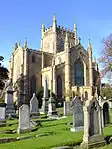
| |
| Pittencrieff Park, Pittencrieff House | Dunfermline | NT0874887215 | 56°04′09″N 3°28′02″W | 17th-century laird's house[113] | 25968 | 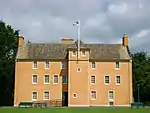
| |
| Pittencrieff Park, Louise Carnegie Memorial Gateway | Dunfermline | NT0881887440 | 56°04′16″N 3°27′59″W | Wrought-iron gates installed 1929[114] | 25972 | 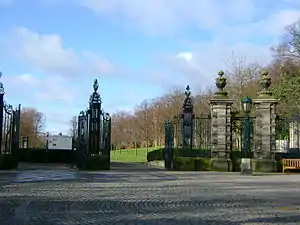
| |
| Dunfermline City Chambers | Dunfermline, Bridge Street | NT0895287412 | 56°04′15″N 3°27′51″W | Baronial town hall by J C Walker, 1879[115] | 25973 | .jpg.webp)
| |
| Abbot House | Dunfermline, Abbot Street | NT0903687379 | 56°04′14″N 3°27′46″W | Later 16th-century town house, converted to heritage centre 1995[116] | 25978 | 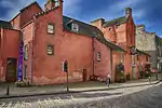
| |
| Former Guildhall | Dunfermline, High Street | NT0912587451 | 56°04′16″N 3°27′41″W | Guildhall by Archibald Elliot, completed 1811[117] | 25999 | 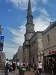
| |
| Hill House | Dunfermline, Limekilns Road | NT0913385957 | 56°03′28″N 3°27′39″W | Earlier 17th-century laird's house[118] | 26050 |
| |
| Pitreavie Castle | Dunfermline | NT1175284859 | 56°02′54″N 3°25′06″W | Early-17th-century laird's house, extended 1885 by Charles Kinnear[119] | 26058 | 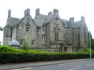
| |
| Pilmuir Works | Dunfermline, Pilmuir Street | NT0909187789 | 56°04′27″N 3°27′43″W | Textile factory, warehouses and offices by Thomas Hyslop Ure, 1883 to 1901[120] | 26073 | 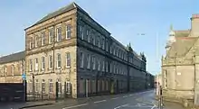
| |
| Elie Castle | Elie, South Street | NT4909299963 | 56°11′22″N 2°49′19″W | 17th-century L-plan house[121] | 31029 |
| |
| Moncrief House | Falkland, High Street | NO2534007414 | 56°15′12″N 3°12′24″W | 17th-century town house[122] | 31274 | .jpg.webp)
| |
| Falkland Town Hall | Falkland, High Street | NO2528507392 | 56°15′11″N 3°12′27″W | Classical town hall by Thomas Barclay, 1800[123] | 31277 | 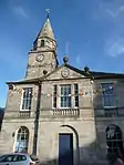
| |
| Brunton House | Falkland, Brunton Street | NO2523907311 | 56°15′09″N 3°12′29″W | Town house dated 1712[124] | 31328 | 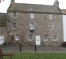
| |
| Inverkeithing Town House | Inverkeithing, Townhall Street | NT1304082924 | 56°01′53″N 3°23′49″W | 18th-century town hall[125] | 35087 | 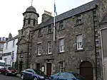
| |
| Inverkeithing Mercat Cross | Inverkeithing, Bank Street | NT1301082872 | 56°01′51″N 3°23′51″W | 16th-century market cross[126] | 35088 | 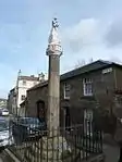
| |
| Thomson's House | Inverkeithing, Bank Street | NT1304282890 | 56°01′52″N 3°23′49″W | 17th-century town house[127] | 35090 | .jpg.webp)
| |
| The Friary | Inverkeithing, Queen Street | NT1294982757 | 56°01′47″N 3°23′54″W | Part of 14th-century, remodelled as tenement in the 17th century and converted into a museum in the 1930s[128] | 35100 | 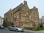
| |
| Fordell's Lodging | Inverkeithing, Church Street | NT1301882973 | 56°01′54″N 3°23′51″W | 17th-century town house[129] | 35103 | 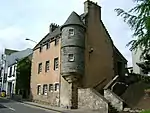
| |
| Innergellie House | Kilrenny | NO5748605098 | 56°14′11″N 2°41′15″W | Unusual 18th-century baroque house[130] | 36005 | 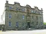
| |
| Anstruther Easter Parish Church (St Adrian's) | Anstruther Easter | NO5665403727 | 56°13′27″N 2°42′02″W | 17th-century T-plan church[131] | 36066 | 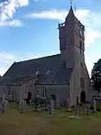
| |
| The Manse | Anstruther Easter, Backdykes | NO5680503625 | 56°13′24″N 2°41′53″W | Late-16th-century house, the oldest inhabited manse in Scotland[132] | 36072 | 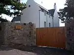
| |
| Scottish Fisheries Museum | Anstruther Easter, Harbour Head | NO5687903483 | 56°13′19″N 2°41′49″W | Group of commercial buildings dating from 16th to 19th centuries, a museum since 1970[133] | 36169 | 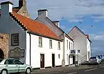
| |
| Anstruther Wester Parish Church (now St Adrian's Church Hall) | Anstruther Wester | NO5644403532 | 56°13′20″N 2°42′14″W | 16th-century church[134] | 36191 | 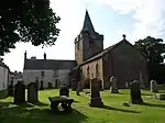
| |
| The White House | Anstruther Wester, 1 The Esplanade | NO5649603497 | 56°13′19″N 2°42′11″W | 18th-century townhouse[135] | 36197 |
| |
| Bowbutts House | Kinghorn, Bruce Terrace | NT2702887367 | 56°04′25″N 3°10′26″W | Late-18th-century townhouse[136] | 36267 |
| |
| 339–343 (Odd Nos) High Street | Kirkcaldy | NT2830691801 | 56°06′49″N 3°09′16″W | 17th-century townhouse[137] | 36354 |
| |
| Sailor's Walk | Kirkcaldy, High Street | NT2842892041 | 56°06′57″N 3°09′09″W | 15th-century house, rebuilt in the 17th century. Said to be the oldest building in Kirkcaldy[138] | 36358 | 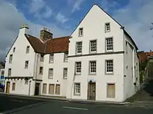
| |
| Pathhead Medical Centre, Path House | Kirkcaldy, Nether Street | NT2874192460 | 56°07′10″N 3°08′52″W | Late-17th-century house, renovated as a medical centre[139] | 36399 | 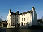
| |
| Former Scottish Linoleum Works, South Factory (Nairn's Linoleum Works) | Kirkcaldy, Den Road | Not listed | NT2859992800 | 56°07′21″N 3°09′00″W | Late-19th-century factory[140] | 36400 |
|
| Ravenscraig Park, Dovecot | Ravenscraig, Kirkcaldy | NT2932092490 | 56°07′12″N 3°08′18″W | Late-16th-century beehive dovecot[141] | 36405 | 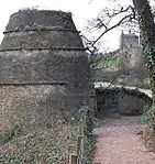
| |
| Bay House | Dysart, Panhall | NT3033592924 | 56°07′26″N 3°07′20″W | 16th-century house, restored in 1969 as part of the National Trust for Scotland Little Houses Scheme[142] | 36407 |
| |
| The Anchorage | Dysart, Shore Road | NT3041692980 | 56°07′28″N 3°07′15″W | 16th-century house, restored in the 1960s[143] | 36414 |
| |
| St Serf's Kirk | Dysart, Panhall | NT3034492951 | 56°07′27″N 3°07′19″W | Ruined church of circa 1500[144] | 36415 | 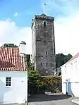
| |
| Dysart Tolbooth and Town Hall | Dysart, Victoria Street | NT3041193161 | 56°07′34″N 3°07′16″W | 16th-century municipal buildings, rebuilt in the 18th century[145] | 36418 | 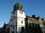
| |
| St David's | Dysart, Fitzroy Square | NT3029593063 | 56°07′31″N 3°07′22″W | Late-16th-century townhouse[146] | 36425 |
| |
| The Towers | Dysart, East Quality Street | NT3028793234 | 56°07′36″N 3°07′23″W | 16th-century house[147] | 36434 |
| |
| Ladybank Station (Main West Block) | Ladybank | NO3063509645 | 56°16′27″N 3°07′18″W | Mid 19th-century station in picturesque classical style[148] | 36925 | 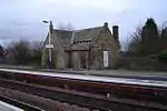
| |
| St Drostan's Parish Church | Markinch | NO2974501967 | 56°12′18″N 3°08′03″W | 18th-century church with Norman tower of circa 1200[149] | 37644 | 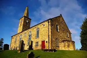
| |
| Pittenweem Parish Church | Pittenweem, High Street | NO5491202601 | 56°12′50″N 2°43′43″W | 16th-century church[150] | 39868 | 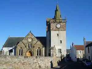
| |
| The Priory | Pittenweem, Marygate | NO5495602573 | 56°12′49″N 2°43′40″W | 16th-century and later buildings, now used as houses and town hall[151] | 39871 |
| |
| The Priory, Gatehouse | Pittenweem | NO5497402602 | 56°12′50″N 2°43′39″W | 15th-century gatehouse[152] | 39872 | 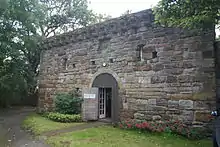
| |
| Kelly Lodge | Pittenweem, High Street | NO5483302557 | 56°12′48″N 2°43′47″W | 16th-century townhouse, rebuilt in the 1960s[153] | 39905 | _Lodge%252C_23_High_Street_(geograph_3466304).jpg.webp)
| |
| Gyles House | Pittenweem, The Gyles | NO5506302448 | 56°12′45″N 2°43′34″W | 17th-century sea-captain's house[154] | 39959 | .jpg.webp)
| |
| 4-6 The Gyles | Pittenweem | NO5505802473 | 56°12′46″N 2°43′34″W | Late-16th-century townhouse[155] | 39961 |
| |
| 18 East Shore | Pittenweem | NO5493902488 | 56°12′46″N 2°43′41″W | Late-17th-century townhouse[156] | 39978 |
| |
| St Andrews Cathedral | St Andrews | NO5141516687 | 56°20′24″N 2°47′15″W | Ruin of 13th-century church[157] | 40585 | 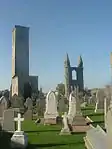
| |
| St Andrews Priory | St Andrews | NO5141316619 | 56°20′22″N 2°47′15″W | Ruin of 13th-century monastery[158] | 40586 |
| |
| St Andrews Cathedral Graveyard | St Andrews | NO5145916661 | 56°20′23″N 2°47′12″W | Monuments of 16th century and later[159] | 40587 |
| |
| St Rule's Church | St Andrews | NO5147516648 | 56°20′23″N 2°47′11″W | Ruin of 11th or 12th-century church[160] | 40588 | 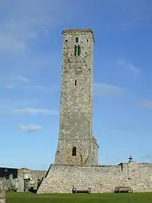
| |
| St Andrews Cathedral Precinct Wall | St Andrews | NO5143716581 | 56°20′21″N 2°47′14″W | 14th-century walls with three gates and 13 towers[161] | 40589 | 
| |
| The Pend | St Andrews, South Street | NO5131216642 | 56°20′23″N 2°47′21″W | 14th-century gatehouse[162] | 40590 | 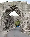
| |
| St Andrews Harbour | St Andrews | NO5165516607 | 56°20′22″N 2°47′01″W | Medieval pier and harbour, repeatedly rebuilt and expanded until the 19th century[163] | 40596 | 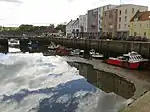
| |
| The Roundel | St Andrews, South Street | NO5129516675 | 56°20′24″N 2°47′22″W | 16th and 17th-century townhouse[164] | 40600 |
| |
| 3 South Street | St Andrews | NO5128516673 | 56°20′24″N 2°47′23″W | 16th and 17th-century townhouse[165] | 40601 |
| |
| 67, 69 South Street | St Andrews | NO5104316661 | 56°20′23″N 2°47′37″W | 16th-century townhouse[166] | 40623 |
| |
| 71 South Street | St Andrews | NO5103116663 | 56°20′23″N 2°47′37″W | 16th or 17th-century townhouse[167] | 40624 | 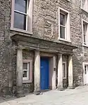
| |
| Holy Trinity Church | St Andrews, South Street | NO5091716665 | 56°20′23″N 2°47′44″W | 15th-century church[168] | 40633 | 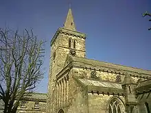
| |
| Queen Mary's House | St Andrews, South Street | NO5126616634 | 56°20′22″N 2°47′24″W | 16th-century townhouse[169] | 40662 |
| |
| St Leonard's Chapel | St Andrews, South Street | NO5127216602 | 56°20′21″N 2°47′23″W | Chapel circa 1200, rebuilt in the 16th century[170] | 40666 |
| |
| South Court | St Andrews, South Street | NO5114716604 | 56°20′21″N 2°47′31″W | 15th to 17th-century townhouse[171] | 40676 |
| |
| St Mary's College | St Andrews, South Street | NO5097216586 | 56°20′21″N 2°47′41″W | 16th-century college buildings[172] | 40686 | 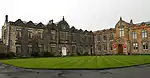
| |
| University Library Original Building | St Andrews, South Street | NO5102116588 | 56°20′21″N 2°47′38″W | 17th-century library[173] | 40687 |
| |
| Madras College Main Building | St Andrews, South Street | NO5077316438 | 56°20′16″N 2°47′52″W | College building of 1832 by William Burn[174] | 40703 | 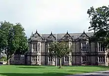
| |
| West Port (Southgait Port) | St Andrews | NO5059616550 | 56°20′19″N 2°48′03″W | 16th-century gatehouse[175] | 40723 | 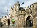
| |
| Dean's Court | St Andrews, North Street | NO5129016723 | 56°20′25″N 2°47′22″W | Early-16th-century manse[176] | 40756 |
| |
| 71 North Street | St Andrews | NO5102416837 | 56°20′29″N 2°47′38″W | 15th-century and later townhouse[177] | 40770 |
| |
| St Salvator's Chapel | St Andrews, North Street | NO5099716844 | 56°20′29″N 2°47′39″W | 15th-century church with later alterations[178] | 40771 | 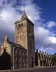
| |
| All Saint's Episcopal Church | St Andrews, North Castle Street | NO5119416809 | 56°20′28″N 2°47′28″W | Early-20th-century Gothic church by John Douglas[179] | 40861 |
| |
| 11, 13 College Street | St Andrews | NO5096116784 | 56°20′27″N 2°47′42″W | 16th-century townhouse[180] | 40868 |
| |
| Bogward Dovecot | St Andrews | NO4918215593 | 56°19′48″N 2°49′24″W | 16th-century beehive doocot[181] | 40932 | 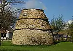
| |
| Beam-Engine House | Thornton | NT2919397269 | 56°09′46″N 3°08′30″W | Early-19th-century classical engine house[182] | 42992 |
| |
| East and West Battery Piers | North Queensferry, Battery Road | NT1338780174 | 56°00′24″N 3°23′26″W | Early-19th-century piers by John Rennie the Elder[183] | 43862 |
| |
| Blair Castle (Carlow Convalescent Home for Miners) | Culross | NS9686385862 | 56°03′16″N 3°39′27″W | Early-18th-century country house in the style of Robert Adam[184] | 46425 | 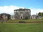
| |
| Glassmount Conservatory | Glassmount House, Kinghorn | NT2459788527 | 56°05′01″N 3°12′48″W | Late-19th-century glasshouses by Mackenzie & Moncur[185] | 46869 |
| |
| Dunfermline Abbey, remains of Dorter and Reredorter ranges | Dunfermline | Delisted | NT0899487243 | 56°04′10″N 3°27′48″W | Later 13th-century undercrofts[186] | 46894 |
|
| Dunfermline Abbey, remains of Frater range | Dunfermline | Delisted | NT0896387261 | 56°04′10″N 3°27′50″W | Remains of earlier 14th-century refectory block[187] | 46895 | .jpg.webp)
|
| Bishop Leighton's House | Culross, 7 Mid Causeway | NS9866085915 | 56°03′19″N 3°37′44″W | Early-17th-century house[188] | 48815 |
| |
| Forth Road Bridge [note 3] | North Queensferry | NT1253579638 | 56°00′06″N 3°24′15″W[note 3]) | Suspension bridge opened 1964[189] | 49165 | 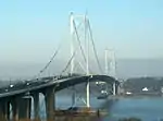
| |
| Easterheughs | Dalachy, Aberdour | NT2103085988 | 56°03′37″N 3°16′11″W | Replica tower house, built in the 1950s by William Thomas, manager of Burntisland Aluminium Works[190] | 49686 |
| |
| St Columba's Parish Church | Glenrothes, Church Street | NO2696800916 | 56°11′43″N 3°10′43″W | Church of Scotland church by Wheeler & Sproson, completed 1962[191] | 49999 | 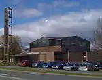
| |
| Kincardine Bridge | Kincardine | NS9256287165 | 56°03′55″N 3°43′38″W | Road bridge by Sir Alexander Gibb & Partners and James Miller, 1931[192] | 50078 | 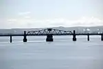
| |
| Crail Airfield, Technical Area, Air Ministry Laboratory Trainer Building, No 62357 09269 | Crail | NO6235709269 | 56°16′28″N 2°36′34″W | World War II-era bomber training building, possibly unique[193] | 50549 |
| |
| Crail Airfield, Technical Area, Control Tower, No 62565 09048 | Crail | NO6256609048 | 56°16′21″N 2°36′22″W | World War II era control tower[194] | 50552 | 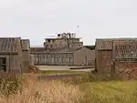
| |
| Crail Airfield, Technical Area, Engine And Aircraft Repair Shop, No 62507 09328 | Crail | NO6250709328 | 56°16′30″N 2°36′25″W | World War II era hangar[195] | 50557 |
| |
| Crail Airfield, Technical Area, Torpedo Attack Training Building, No 62451 09377 | Crail | NO6245109377 | 56°16′31″N 2°36′29″W | World War II era training building, a rare example of its type[196] | 50573 |
| |
| Andrew Melville Hall, University of St Andrews | North Haugh, St Andrews, Fife | 18 November 2011 | NO4956716755 | 56°20′26″N 2°49′03″W | James Stirling | 51846 | 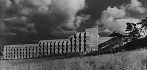
|
See also
Notes
- Sometimes known as OSGB36, the grid reference (where provided) is based on the British national grid reference system used by the Ordnance Survey.
• "Guide to National Grid". Ordnance Survey. Retrieved 2007-12-12.
• "Get-a-map". Ordnance Survey. Retrieved 2007-12-17. - Historic Environment Scotland assign a unique alphanumeric identifier to each designated site in Scotland, for listed buildings this always begins with "LB", for example "LB12345".
- Also in City of Edinburgh, as it crosses the Forth which is the council boundary
References
- Guide to the Protection of Scotland's Listed Buildings (PDF). Historic Scotland. 2009. p. 4. ISBN 978-1-84917-013-0. Retrieved 2010-05-05.
- "What is Listing?". Historic Scotland. Retrieved 2010-05-05.
- Scottish Historic Environment Policy (PDF). Historic Scotland. October 2008. pp. 24–25. ISBN 978-1-84917-002-4. Retrieved 2010-05-05.
- Guide to the Protection of Scotland’s Listed Buildings, p. 17.
- "Gibliston House: Listed Building Report". Historic Scotland.
- "Limekilns, 8 Academy Square, The King's Cellar: Listed Building Report". Historic Scotland.
- "Creich Castle Doocot: Listed Building Report". Historic Scotland.
- "Bishop Bridge Over Ceres Burn, Including Approach Walls Linking To Folk Museum, Ceres: Listed Building Report". Historic Scotland.
- "St John's Masonic Lodge Off High Street, Ceres, Including Garden Walls: Listed Building Report". Historic Scotland.
- "Southern Outbuilding Of Brand's Hotel, High Street, Ceres: Listed Building Report". Historic Scotland.
- "Fife Folk Museum (Central And North Fife Preservation Society) High Street, Ceres: Listed Building Report". Historic Scotland.
- "Balcaskie House: Listed Building Report". Historic Scotland.
- "Balcaskie House, Terraced Garden: Listed Building Report". Historic Scotland.
- "Balcaskie House East Gatepiers And Twin Dovecots: Listed Building Report". Historic Scotland.
- "Kellie Castle Stable Courtyard And Walled Garden: Listed Building Report". Historic Scotland.
- "Balmerino Abbey - Barn: Listed Building Report". Historic Scotland.
- "Dairsie Bridge Over River Eden: Listed Building Report". Historic Scotland.
- "Dairsie Old Church (St Mary's) Former Session House, Cemetery Walls And Gatepiers: Listed Building Report". Historic Scotland.
- "Hill Of Tarvit House, Terraced Garden, Walled Garden: Listed Building Report". Historic Scotland.
- "Tarvit Farm: Listed Building Report". Historic Scotland.
- "Benarty House: Listed Building Report". Historic Scotland.
- "Benarty Steading: Listed Building Report". Historic Scotland.
- "Dunimarle Castle: Listed Building Report". Historic Scotland.
- "Inchcolm Abbey, Including Ancillary Buildings: Listed Building Report". Historic Scotland.
- "The Murrell Including Ancillary Buildings, Garden Terraces, Walled Raised And Water Gardens And Rockery: Listed Building Report". Historic Scotland.
- "Aberdour Kirk, St Filan's (Church Of Scotland) Including Graveyard And Boundary Walls: Listed Building Report". Historic Scotland.
- "Aberdour,Aberdour Castle Walled Garden With Sundial: Listed Building Report". Historic Scotland.
- "Aberdour, Aberdour Castle Dovecot: Listed Building Report". Historic Scotland.
- "Aberdour, Shore Road, Seabank House Including Boundary Walls: Listed Building Report". Historic Scotland.
- "Aberdour, Aberdour House: Listed Building Report". Historic Scotland.
- "Aberdour, Aberdour Castle Sundial (Formerly At Aberdour House): Listed Building Report". Historic Scotland.
- "Donibristle House: Listed Building Report". Historic Scotland.
- "Donibristle Chapel: Listed Building Report". Historic Scotland.
- "Fordell Castle: Listed Building Report". Historic Scotland.
- "Fordell Chapel: Listed Building Report". Historic Scotland.
- "St. Bridget's Church: Listed Building Report". Historic Scotland.
- "Charlestown, Harbour Road, Limekilns: Listed Building Report". Historic Scotland.
- "Broomhall Including Garden Balustrade, Kitchen Court Walls Larder And Stables: Listed Building Report". Historic Scotland.
- "Pitfirrane Castle Including Gatepiers: Listed Building Report". Historic Scotland.
- "Logie House Including Garden Wall, Greenhouse And Gatepiers: Listed Building Report". Historic Scotland.
- "Logie House, Steading: Listed Building Report". Historic Scotland.
- "Greenside Farm Steading: Listed Building Report". Historic Scotland.
- "Wormiston, Doocot: Listed Building Report". Historic Scotland.
- "Listed Building Report". Historic Scotland.
- "Aberdour, High Street, East Lodge Including Screen Walls, Gates, Gatepiers And Railings: Listed Building Report". Historic Scotland.
- "Charleton House: Listed Building Report". Historic Scotland.
- "Balcarres House, Including Outbuildings Dower House And Front Entrance Gates: Listed Building Report". Historic Scotland.
- "Balcarres House - Sundial: Listed Building Report". Historic Scotland.
- "House Of Falkland (St Ninian's Rc School) Including Terraces And Garden Ornaments: Listed Building Report". Historic Scotland.
- "Randerston Farm House: Listed Building Report". Historic Scotland.
- "Falkland Palace: Listed Building Report". Historic Scotland.
- "Falkland Palace Royal Stables And Tennis Court Or Caichpule: Listed Building Report". Historic Scotland.
- "Kilmany Parish Kirk: Listed Building Report". Historic Scotland.
- "Parish Kirk Of St Athernase: Listed Building Report". Historic Scotland.
- "Doocot, Leuchars Castle: Listed Building Report". Historic Scotland.
- "Earlshall: Listed Building Report". Historic Scotland.
- "Earlshall Doocot: Listed Building Report". Historic Scotland.
- "Pitcullo Castle: Listed Building Report". Historic Scotland.
- "Guardbridge (Old) Over River Eden: Listed Building Report". Historic Scotland.
- "VICARSFORD CEMETERY CHAPELLB8863". Historic Environment Scotland.
- "West Pitkierie Dovecot: Listed Building Report". Historic Scotland.
- "Elie House, Convent Of St Marty Reparatrice: Listed Building Report". Historic Scotland.
- "Scotscraig House Gateway And Walled Gardens: Listed Building Report". Historic Scotland.
- "Lathrisk House And Gatepiers: Listed Building Report". Historic Scotland.
- "Raith Estate, Raith House: Listed Building Report". Historic Scotland.
- "Raith Estate, Stable Court (Home Farm): Listed Building Report". Historic Scotland.
- "Leslie House With Conservatory, Terraced Garden And Boundary Walls: Listed Building Report". Historic Scotland.
- "Forth Bridge: Listed Building Report". Historic Scotland.
- "North Queensferry, Town Pier: Listed Building Report". Historic Scotland.
- "Old Duloch House, Including Former Stables, Boundary Walls, Gatepiers And Walled Garden: Listed Building Report". Historic Scotland.
- "North Queensferry, Pierhead, Lantern Tower: Listed Building Report". Historic Scotland.
- "Melville House Pavilion Blocks And Lodges: Listed Building Report". Historic Scotland.
- "Cunnoquhie House: Listed Building Report". Historic Scotland.
- "Over Rankeilour House, Octagonal Enclosure, And Garage And Gatepiers: Listed Building Report". Historic Scotland.
- "Monimail Tower Or Palace (Also Known As Cardinal Beaton's Tower) And Melville House Garden Walls: Listed Building Report". Historic Scotland.
- "St Monan's Church And Churchyard: Listed Building Report". Historic Scotland.
- "Pitcairlie House: Listed Building Report". Historic Scotland.
- "Town Hall Steeple: Listed Building Report". Historic Scotland.
- "Pitlour House: Listed Building Report". Historic Scotland.
- "Strathtyrum House: Listed Building Report". Historic Scotland.
- "Kenly Green House: Listed Building Report". Historic Scotland.
- "Tulliallan Castle (Scottish Police College): Listed Building Report". Historic Scotland.
- "Balgonie Castle With Curtain Walls, Boundary Walls, Gatepiers And Well: Listed Building Report". Historic Scotland.
- "Balbirnie Park, Balbirnie House With Sundial, Garden Seat, Boundary Wall, Gatepier And Gate: Listed Building Report". Historic Scotland.
- "Durie House With Court Of Offices, Sundial And Walled Garden: Listed Building Report". Historic Scotland.
- "Wemyss Castle: Listed Building Report". Historic Scotland.
- "Cunnoquhie Former Stable Block: Listed Building Report". Historic Scotland.
- "6-9 (Inclusive Nos) Broomhill With Boundary Walls And Railings: Listed Building Report". Historic Scotland.
- "East Leven Street, Burntisland Parish Church (Church Of Scotland): Listed Building Report". Historic Scotland.
- "Crail Parish Church: Listed Building Report". Historic Scotland.
- "Parish Churchyard Walls And Gravestones: Listed Building Report". Historic Scotland.
- "Kirkmay House Hotel 7 Marketgate: Listed Building Report". Historic Scotland.
- "Friar's Court 9 Marketgate (Including Garden Wall S): Listed Building Report". Historic Scotland.
- "The Tolbooth And Town Hall, Marketgate: Listed Building Report". Historic Scotland.
- "The Golf Hotel 4 High Street: Listed Building Report". Historic Scotland.
- "35 Shoregate (The Custom House): Listed Building Report". Historic Scotland.
- "Crail Harbour: Listed Building Report". Historic Scotland.
- "Priory Doocot, Off Nethergate: Listed Building Report". Historic Scotland.
- "Culross, Culross Abbey Church (Church Of Scotland) Including Churchyard And Boundary Walls: Listed Building Report". Historic Scotland.
- "Culross, Culross Abbey House: Listed Building Report". Historic Scotland.
- "Culross, Culross Abbey House Policies, Garden House Including Garden Walls, Terrace, Setts And Seat: Listed Building Report". Historic Scotland.
- "West Kirk Including Churchyard And Boundary Walls: Listed Building Report". Historic Scotland.
- "Culross, Sandhaven, Culross Palace Including Courtyard Walls, Garden Walls And Bessie Bar Well: Listed Building Report". Historic Scotland.
- "Culross, Sandhaven, Culross Town House: Listed Building Report". Historic Scotland.
- "Culross, The Cross, Mercat Cross: Listed Building Report". Historic Scotland.
- "Culross, 5 Mid Causeway, Bishop Leighton's House Including Boundary Wall: Listed Building Report". Historic Scotland.
- "Culross, The Cross, The Study: Listed Building Report". Historic Scotland.
- "Cupar Old St Michael Of Tarvit Parish Church Comprising:- Tower And Remains Of Nave; And: Listed Building Report". Historic Scotland.
- "Preston Lodge, 95 Bonnygate: Listed Building Report". Historic Scotland.
- "Goods Shed At Cupar Railway Station: Listed Building Report". Historic Scotland.
- "Dunfermline Abbey, Nave: Listed Building Report". Historic Scotland.
- "Dunfermline Abbey, New Abbey Parish Church, Church Of Scotland: Listed Building Report". Historic Scotland.
- "Pittencrieff Park, Pittencrieff House, Including Parapet Wall To North: Listed Building Report". Historic Scotland.
- "Pittencrieff Park, Louise Carnegie Memorial Gateway, Including Detached Lamp Standards, Junction Of Bridge Street And Chalmers Street: Listed Building Report". Historic Scotland.
- "3 Bridge Street, City Chambers: Listed Building Report". Historic Scotland.
- "21 Maygate And Abbot Street, Abbot House, Including Gateways And Decorative Ironwork To East And West: Listed Building Report". Historic Scotland.
- "81-85 (Odd Nos) High Street And 4 Guildhall Street, Former Guildhall: Listed Building Report". Historic Scotland.
- "Limekilns Road, Hill House, Including Walled Garden And Two Pairs Of Gatepiers To West: Listed Building Report". Historic Scotland.
- "Off Queensferry Road, Pitreavie Castle: Listed Building Report". Historic Scotland.
- "Pilmuir Street, And Returns To Foundry Street And Cousins Lane, Pilmuir Works, Including Gatepiers And Boundary Wall To West: Listed Building Report". Historic Scotland.
- "Elie The Castle South Street: Listed Building Report". Historic Scotland.
- "Moncrief House, High Street: Listed Building Report". Historic Scotland.
- "Falkland Town Hall, High Street: Listed Building Report". Historic Scotland.
- "Brunton House, Brunton Street (Including Garden Walls): Listed Building Report". Historic Scotland.
- "Townhall Street, Town House: Listed Building Report". Historic Scotland.
- "Bank Street, Mercat Cross: Listed Building Report". Historic Scotland.
- "2, 4 Bank Street, Thomson's House: Listed Building Report". Historic Scotland.
- "Queen Street, The Friary Including Well And Vaulted Cellars: Listed Building Report". Historic Scotland.
- "16, 18 Church Street, Fordell's Lodging: Listed Building Report". Historic Scotland.
- "Innergellie House: Listed Building Report". Historic Scotland.
- "Anstruther Easter Parish Church (St Adrian's): Listed Building Report". Historic Scotland.
- "The Manse, Backdykes Anstruther Easter (Including Garden Walls): Listed Building Report". Historic Scotland.
- "Scottish Fisheries Museum Trust Ltd Harbour Head And 50 East Shore Anstruther Easter: Listed Building Report". Historic Scotland.
- "Anstruther Wester Parish Church (Now St Adrian's Church Hall): Listed Building Report". Historic Scotland.
- "The White House 1 The Esplanade Anstruther Wester: Listed Building Report". Historic Scotland.
- "Bruce Terrace, Bowbutts House With Ancillary Building: Listed Building Report". Historic Scotland.
- "339-343 (Odd Nos) High Street With Boundary Walls: Listed Building Report". Historic Scotland.
- "443-449 (Odd Nos) High Street And Malcolm's Wynd, Sailor's Walk With Boundary Walls: Listed Building Report". Historic Scotland.
- "Nether Street, Pathhead Medical Centre, Path House With Gatepiers And Boundary Wall: Listed Building Report". Historic Scotland.
- "Victoria Road, Former Scottish Linoleum Works, South Factory: Listed Building Report". Historic Scotland.
- "Ravenscraig Park, Dovecot: Listed Building Report". Historic Scotland.
- "Dysart, 1 Pan Ha', Bay House Including Boundary Walls, Gatepiers And Gates: Listed Building Report". Historic Scotland.
- "Dysart, 1 And 2 Shore Road, The Anchorage With Boundary Walls: Listed Building Report". Historic Scotland.
- "Dysart, Shore Road, St Serf's Kirk, Tower And Graveyard Including Boundary Walls: Listed Building Report". Historic Scotland.
- "Dysart, High Street And Victoria Street, Tolbooth And Town Hall: Listed Building Report". Historic Scotland.
- "Dysart, 14 Fitzroy Square, St David's With Outbuilding And Boundary Walls: Listed Building Report". Historic Scotland.
- "Dysart, 43-47 East Quality Street, The Towers With Forecourt Wall: Listed Building Report". Historic Scotland.
- "Ladybank Station (Main West Block): Listed Building Report". Historic Scotland.
- "Kirk Brae, St Drostan's Parish Church: Listed Building Report". Historic Scotland.
- "Pittenweem Parish Church: Listed Building Report". Historic Scotland.
- "The Priory Including North Courtyard Wall And Retaining Walls To Cove Wynd: Listed Building Report". Historic Scotland.
- "The Priory - Gatehouse: Listed Building Report". Historic Scotland.
- "Kelly Lodge, 23 High Street: Listed Building Report". Historic Scotland.
- "Gyles House: Listed Building Report". Historic Scotland.
- "4-6 The Gyles: Listed Building Report". Historic Scotland.
- "18 East Shore: Listed Building Report". Historic Scotland.
- "St Andrews Cathedral: Listed Building Report". Historic Scotland.
- "St Andrews Priory: Listed Building Report". Historic Scotland.
- "Cathedral Graveyard: Listed Building Report". Historic Scotland.
- "St Rule's Church: Listed Building Report". Historic Scotland.
- "Precinct Wall: Listed Building Report". Historic Scotland.
- "The Pend: Listed Building Report". Historic Scotland.
- "St Andrews Harbour: Listed Building Report". Historic Scotland.
- "1 South Street The Roundel, Including Garden Walls: Listed Building Report". Historic Scotland.
- "3 South Street: Listed Building Report". Historic Scotland.
- "67, 69 South Street: Listed Building Report". Historic Scotland.
- "71 South Street: Listed Building Report". Historic Scotland.
- "Holy Trinity Church (Town Kirk), South Street: Listed Building Report". Historic Scotland.
- "4 South Street, Queen Mary's House Including Garden Walls And Grotto: Listed Building Report". Historic Scotland.
- "St Leonard's Chapel: Listed Building Report". Historic Scotland.
- "40 (A-H), 42 South Street, South Court: Listed Building Report". Historic Scotland.
- "St. Mary's College, West Range, Principal's House And Precinct, Including West Boundary Wall: Listed Building Report". Historic Scotland.
- "University Library Original Building: Listed Building Report". Historic Scotland.
- "Madras College Main Building: Listed Building Report". Historic Scotland.
- "West Port (Southgait Port): Listed Building Report". Historic Scotland.
- "Dean's Court, North Street (Including Walls Of Courtyard And Of Garden To North Street): Listed Building Report". Historic Scotland.
- "71 North Street: Listed Building Report". Historic Scotland.
- "St. Salvator's Chapel, Tower And Hebdomadar's Building: Listed Building Report". Historic Scotland.
- "All Saint's Episcopal Church And Ancillary Buildings, North Castle Street: Listed Building Report". Historic Scotland.
- "11, 13 College Street: Listed Building Report". Historic Scotland.
- "Bogward Dovecot: Listed Building Report". Historic Scotland.
- "Thornton, Beam-Engine House: Listed Building Report". Historic Scotland.
- "North Queensferry, Battery Road, East And West Battery Piers Including Shoring And Viewing Area Below Forth Bridge North Cantilever, And Boundary Walls: Listed Building Report". Historic Scotland.
- "Blair Castle (Carlow Convalescent Home For Miners): Listed Building Report". Historic Scotland.
- "Glassmount Conservatory: Listed Building Report". Historic Scotland.
- "Dunfermline Abbey, Remains Of Dorter And Reredorter Ranges: Listed Building Report". Historic Scotland.
- "Dunfermline Abbey, Remains Of Frater Range: Listed Building Report". Historic Scotland.
- "Culross, 7 Mid Causeway, Bishop Leighton's House: Listed Building Report". Historic Scotland.
- "Forth Road Bridge, Including Approach Ramps And Piers: Listed Building Report". Historic Scotland.
- "Easterheughs Including Gate Piers And Boundary Wall, Garage, Boiler House (Former Log Store) And Pump House: Listed Building Report". Historic Scotland.
- "Glenrothes, Church Street, St Columba's Parish Church Including Hall And Bell Tower: Listed Building Report". Historic Scotland.
- "Kincardine Bridge: Listed Building Report". Historic Scotland.
- "Crail Airfield, Technical Area, Air Ministry Laboratory Trainer Building, No 62357 09269: Listed Building Report". Historic Scotland.
- "Crail Airfield, Technical Area, Control Tower, No 62565 09048: Listed Building Report". Historic Scotland.
- "Crail Airfield, Technical Area, Engine And Aircraft Repair Shop, No 62507 09328: Listed Building Report". Historic Scotland.
- "Crail Airfield, Technical Area, Torpedo Attack Training Building, No 62451 09377: Listed Building Report". Historic Scotland.
External links
![]() Media related to Category A listed buildings in Fife at Wikimedia Commons
Media related to Category A listed buildings in Fife at Wikimedia Commons