List of Category A listed buildings in West Lothian
This is a list of Category A listed buildings in West Lothian, Scotland.
In Scotland, the term listed building refers to a building or other structure officially designated as being of "special architectural or historic interest".[1] Category A structures are those considered to be "buildings of national or international importance, either architectural or historic, or fine little-altered examples of some particular period, style or building type."[2] Listing was begun by a provision in the Town and Country Planning (Scotland) Act 1947, and the current legislative basis for listing is the Planning (Listed Buildings and Conservation Areas) (Scotland) Act 1997.[3] The authority for listing rests with Historic Scotland, an executive agency of the Scottish Government, which inherited this role from the Scottish Development Department in 1991. Once listed, severe restrictions are imposed on the modifications allowed to a building's structure or its fittings. Listed building consent must be obtained from local authorities prior to any alteration to such a structure.[3] There are approximately 47,400 listed buildings in Scotland, of which around 8% (some 3,800) are Category A.[4]
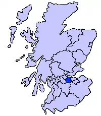
The council area of West Lothian covers 427 square kilometres (165 sq mi), and has a population of around 169,500. There are 42 Category A listed buildings within the area, ranging from Linlithgow Palace, a principal residence of the Kings of Scotland, to more modest farms and cottages such as Gowanbank or Woodcockdale. Historic churches include those at Abercorn, Mid Calder and Linlithgow. Several small castles and tower houses merit Category A listing. More recent country houses include Hopetoun House, worked on successively by Sir William Bruce, William Adam and Robert Adam. A number of 19th century viaducts and aqueducts carry railways and canals across the River Avon and River Almond. In the historic royal burgh of Linlithgow, besides the palace and parish church, several town houses are listed at Category A. Few recent buildings in the area merit Category A listing, with only one building dating from the post-war period (Brucefield Church).
Listed buildings
| Name | Location | Date Listed | Grid Ref. [note 1] | Geo-coordinates | Notes | LB Number [note 2] | Image |
|---|---|---|---|---|---|---|---|
| Abercorn Church | Abercorn | NT081790 | 55°59′44″N 3°28′27″W | 12th-century church with later alterations[5] | 612 | 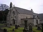
| |
| Hopetoun House | 4 kilometres (2.5 mi) west of South Queensferry | NT088790 | 55°59′45″N 3°27′47″W | Late 17th-century country house[6] | 613 | 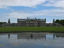
| |
| Hopetoun House estate buildings and steading | Hopetoun House Estate | NT0901678851 | 55°59′38″N 3°27′37″W | 18th-century estate buildings[7] | 614 | 
| |
| Midhope Castle | Abercorn | NT0728378685 | 55°59′32″N 3°29′16″W | 16th-century tower house[8] | 630 | 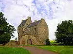
| |
| House of the Binns | 1.5 kilometres (0.93 mi) south of Blackness | NT0508078567 | 55°59′26″N 3°31′23″W | Country house dating to 1612–1630[9] | 632 | 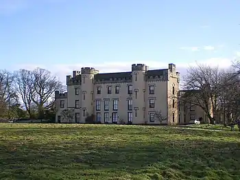
| |
| Duntarvie Castle | 2km north of Winchburgh | NT0905076477 | 55°58′22″N 3°27′32″W | Scots Renaissance house of circa 1590[10] | 6422 | 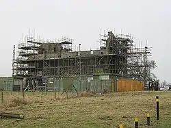
| |
| Bangour Village Hospital, excluding villas 9, 23-29, 31, and boiler house | 1 kilometre (0.62 mi) west of Dechmont | NT0322171218 | 55°55′27″N 3°33′01″W | Former hospital built 1898–1906, and church dating from the 1920s[11] | 6588 | 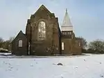
| |
| Hatton House, south entrance gates | 2 kilometres (1.2 mi) south of Ratho | NT1279968444 | 55°54′04″N 3°23′46″W | Gateway built 1692 as an entrance to the now-demolished Hatton House[12] | 7355 | 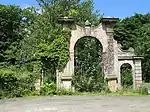
| |
| Linhouse Viaduct | 1.5 kilometres (0.93 mi) east of Murieston | NT076647 | 55°52′01″N 3°28′38″W | 1842 railway viaduct carrying the Edinburgh to Carstairs railway over the Linhouse Water[13] | 7365 | 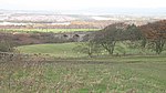
| |
| Almondell Bridge[note 3] | 1 kilometre (0.62 mi) north of East Calder in Almondell and Calderwood Country Park | NT0881668838 | 55°54′14″N 3°27′36″W[note 4]) | 1800 bridge over the River Almond[14][15] | 7370 | 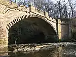
| |
| Almondell Bridge[note 6] | 1 kilometre (0.62 mi) north of East Calder in Almondell and Calderwood Country Park | NT0881668838 | 55°54′14″N 3°27′36″W[note 7]) | 1800 bridge over the River Almond[16][17] | 14228 |
| |
| Almondell Aqueduct | Almondell and Calderwood Country Park, East Calder | NT0864068528 | 55°54′04″N 3°27′46″W | 1820 aqueduct built to feed the Union Canal[18] | 7371 | 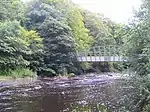
| |
| Blackburn House | Between Blackburn and Seafield | NT000656 | 55°52′25″N 3°35′56″W | 18th-century country house[19] | 7419 | 
| |
| Broxburn Viaduct | 2.5 kilometres (1.6 mi) east of Broxburn | NT1057872525 | 55°56′15″N 3°25′59″W | Railway viaduct carrying the Edinburgh to Glasgow railway over the A89 road[20] | 7427 | 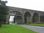
| |
| Almond Valley Viaduct [note 9] | 3 kilometres (1.9 mi) east of Broxburn | NT1123772183 | 55°56′04″N 3°25′21″W[note 9]) | 1842 railway viaduct carrying the Edinburgh to Glasgow railway over the River Almond[21] | 7428 | 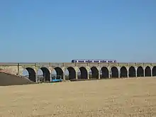
| |
| Almond Aqueduct [note 9] | 3 kilometres (1.9 mi) south-east of Broxburn | NT104706 | 55°55′14″N 3°26′04″W[note 9]) | 1820 aqueduct carrying the Union Canal over the River Almond[22] | 7430 | 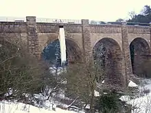
| |
| Niddry Castle | Near Winchburgh | NT095743 | 55°57′13″N 3°27′00″W | Tower house of circa 1500[23] | 7437 | 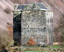
| |
| Avon Aqueduct [note 10] | 3 kilometres (1.9 mi) south-west of Linlithgow | NS967758 | 55°57′52″N 3°39′20″W[note 10]) | 1822 aqueduct carrying the Union Canal over the River Almond[24] | 7468 | 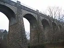
| |
| Kingscavil Cottages | 3 kilometres (1.9 mi) east of Linlithgow | NT030764 | 55°58′16″N 3°33′18″W | 1873 cottages and former schoolhouse[25] | 7482 | 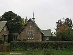
| |
| Grange House | 1.5 kilometres (0.93 mi) north of Linlithgow | NT0002878768 | 55°59′29″N 3°36′15″W | Early 20th-century country house[26] | 12972 |
| |
| Ochiltree Castle | 3.5 kilometres (2.2 mi) south-east of Linlithgow | NT0326474760 | 55°57′22″N 3°33′03″W | Early 17th-century tower house[27] | 12978 | 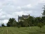
| |
| Preston House | Preston Road, Linlithgow | NS9957875849 | 55°57′54″N 3°36′37″W | 19th-century baronial house by William Burn and David Bryce[28] | 12983 |
| |
| Avon Viaduct [note 10] | Linlithgow Bridge | NS9816076951 | 55°58′29″N 3°38′00″W[note 10]) | 1842 viaduct carrying the Edinburgh to Glasgow railway over the River Avon[29] | 12985 | 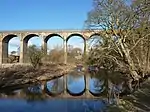
| |
| Woodcockdale, cottages and stables | 2.5 kilometres (1.6 mi) south-west of Linlithgow | NS9758775895 | 55°57′54″N 3°38′32″W | Early 19th-century stables and cottages[30] | 12989 | 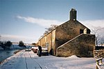
| |
| Mid Calder Parish Church (St John's) | Main Street, Mid Calder | NT0737267323 | 55°53′24″N 3°28′57″W | 16th-century Gothic church[31] | 14144 | 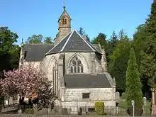
| |
| Calder House | Mid Calder | NT0725967251 | 55°53′22″N 3°29′04″W | 16th- or 17th-century mansion, incorporating walls of earlier fortalice[32] | 14153 | 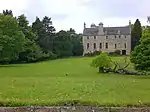
| |
| Calder House, east gateway | West Calder Road, Mid Calder | NT0742367187 | 55°53′20″N 3°28′54″W | Ornamental gateway of circa 1670[33] | 14155 | 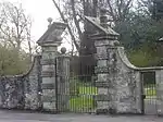
| |
| Linhouse | 2 kilometres (1.2 mi) south of Murieston | NT062629 | 55°51′02″N 3°29′56″W | 1589 country house[34] | 14156 |
| |
| Houstoun House | Uphall | NT0526471334 | 55°55′33″N 3°31′04″W | 17th-century house, now a hotel[35] | 14243 | .jpg.webp)
| |
| Gowanbank | 3 kilometres (1.9 mi) north-west of Armadale | NS9157071261 | 55°55′20″N 3°44′12″W | 19th-century farmhouse, steading and cottage by Sir James Gowans[36] | 14557 | 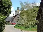
| |
| Bathgate Academy | Marjoribanks Street, Bathgate | NS9794768697 | 55°54′02″N 3°38′01″W | 19th-century Greek revival school[37] | 22125 | 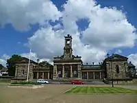
| |
| Linlithgow Burgh Halls | The Cross, Linlithgow | NT0021977204 | 55°58′39″N 3°36′02″W | 17th-century town house, including former jail and court house[38] | 37362 | 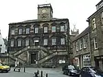
| |
| Cross House | 5 The Cross, Linlithgow | NT0018277195 | 55°58′38″N 3°36′04″W | 18th-century house, Category A listed for its interiors[39] | 37363 | 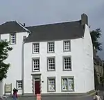
| |
| St Michael's Well | High Street, Linlithgow | NT0041377119 | 55°58′36″N 3°35′51″W | Well dated 1720 with a statue of St Michael[40] | 37383 | 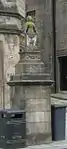
| |
| West Port House | 297-299 High Street, Linlithgow | NS9965377027 | 55°58′33″N 3°36′34″W | Laird's house, circa 1600 with later additions[41] | 37430 | 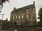
| |
| Hamilton's Land | 38-44 High Street, Linlithgow | NT0039877139 | 55°58′37″N 3°35′52″W | Early 17th-century tenement building, restored 1958[42] | 37438 | 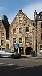
| |
| Hamilton's Land | 46-48 High Street, Linlithgow | NT0038977143 | 55°58′37″N 3°35′52″W | Early 17th-century tenement building, restored 1958[43] | 37439 |
| |
| Dovecot | Learmonth Gardens, Linlithgow | NT0034577008 | 55°58′32″N 3°35′54″W | 16th-century beehive dovecote[44] | 37468 | 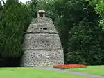
| |
| Linlithgow Palace | Linlithgow Peel | NT0019677325 | 55°58′43″N 3°36′03″W | Former royal palace built over 15th to 17th centuries, now in ruins[45] | 37469 | 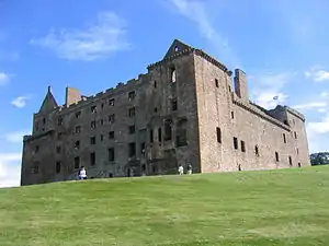
| |
| Linlithgow Palace Gateway | Linlithgow Peel | NT0019677279 | 55°58′41″N 3°36′03″W | Gateway to former royal palace, circa 1535[46] | 37470 | 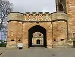
| |
| St Michael's Church | Linlithgow Peel | NT002772 | 55°58′40″N 3°36′00″W | 15th-century parish church[47] | 37499 | 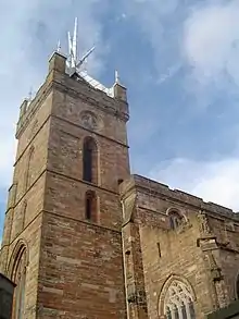
| |
| Brucefield Church | East Main Street, Whitburn, West Lothian | 4 December 2008 | NS9485765021 | 55°52′01″N 3°40′54″W | Rowand Anderson, Kininmonth and Paul (William Kininmonth and Tom Duncan) | 51254 | 
|
See also
Notes
- Sometimes known as OSGB36, the grid reference (where provided) is based on the British national grid reference system used by the Ordnance Survey.
• "Guide to National Grid". Ordnance Survey. Retrieved 2007-12-12.
• "Get-a-map". Ordnance Survey. Retrieved 2007-12-17. - Historic Environment Scotland assign a unique alphanumeric identifier to each designated site in Scotland, for listed buildings this always begins with "LB", for example "LB12345".
- Almondell Bridge is listed twice
- Almondell Bridge is listed twice
- Almondell Bridge is listed twice
- Almondell Bridge is listed twice
- Almondell Bridge is listed twice
- Almondell Bridge is listed twice
- Also in City of Edinburgh, as it crosses the River Almond which is the council boundary
- Also in Falkirk, as it crosses the River Avon which is the council boundary
References
- Guide to the Protection of Scotland’s Listed Buildings (PDF). Historic Scotland. 2009. p. 4. ISBN 978-1-84917-013-0. Retrieved 2010-05-05.
- "What is Listing?". Historic Scotland. Retrieved 2010-05-05.
- Scottish Historic Environment Policy (PDF). Historic Scotland. October 2008. pp. 24–25. ISBN 978-1-84917-002-4. Retrieved 2010-05-05.
- Guide to the Protection of Scotland’s Listed Buildings, p. 17.
- "Abercorn Church, Listed Building Report". Historic Scotland. Retrieved 2010-05-18.
- "Hopetoun House, Listed Building Report". Historic Scotland. Retrieved 2010-05-18.
- "Hopetoun House estate buildings and steading, Listed Building Report". Historic Scotland. Retrieved 2010-05-18.
- "Midhope Castle, Listed Building Report". Historic Scotland. Retrieved 2010-05-18.
- "House of the Binns, Listed Building Report". Historic Scotland. Retrieved 2010-05-18.
- "Duntarvie Castle, Listed Building Report". Historic Scotland. Retrieved 2010-05-18.
- "Bangour Village Hospital, Listed Building Report". Historic Scotland. Retrieved 2010-05-18.
- "Hatton House, south entrance gates, Listed Building Report". Historic Scotland. Retrieved 2010-05-18.
- "Linhouse Viaduct, Listed Building Report". Historic Scotland. Retrieved 2010-05-18.
- "Almondell Bridge, Listed Building Report". Historic Scotland. Retrieved 2010-05-18.
- "Almondell Bridge, Listed Building Report". Historic Scotland. Retrieved 2010-05-18.
- "Almondell Bridge, Listed Building Report". Historic Scotland. Retrieved 2010-05-18.
- "Almondell Bridge, Listed Building Report". Historic Scotland. Retrieved 2010-05-18.
- "Almondell Aqueduct, Listed Building Report". Historic Scotland. Retrieved 2010-05-18.
- "Blackburn House, Listed Building Report". Historic Scotland. Retrieved 2010-05-18.
- "Broxburn Viaduct, Listed Building Report". Historic Scotland. Retrieved 2010-05-18.
- "Almond Valley Viaduct, Listed Building Report". Historic Scotland. Retrieved 2010-05-18.
- "Almond Aqueduct, Listed Building Report". Historic Scotland. Retrieved 2010-05-18.
- "Niddry Castle, Listed Building Report". Historic Scotland. Retrieved 2010-05-18.
- "Avon Aqueduct, Listed Building Report". Historic Scotland. Retrieved 2010-05-18.
- "Kingscavil Cottages and Schoolhouse, Listed Building Report". Historic Scotland. Retrieved 2010-05-18.
- "Grange House, Listed Building Report". Historic Scotland. Retrieved 2010-05-18.
- "Ochiltree Castle, Listed Building Report". Historic Scotland. Retrieved 2010-05-18.
- "Preston House, Listed Building Report". Historic Scotland. Retrieved 2010-05-18.
- "Avon Viaduct, Listed Building Report". Historic Scotland. Retrieved 2010-05-18.
- "Woodcockdale, Listed Building Report". Historic Scotland. Retrieved 2010-05-18.
- "Mid Calder Parish Church (St John's), Listed Building Report". Historic Scotland. Retrieved 2010-05-18.
- "Calder House, Listed Building Report". Historic Scotland. Retrieved 2010-05-18.
- "Calder House, east gateway, Listed Building Report". Historic Scotland. Retrieved 2010-05-18.
- "Linhouse, Listed Building Report". Historic Scotland. Retrieved 2010-05-18.
- "Houstoun House, Listed Building Report". Historic Scotland. Retrieved 2010-05-18.
- "Gowanbank, Listed Building Report". Historic Scotland. Retrieved 2010-05-18.
- "Bathgate Academy, Listed Building Report". Historic Scotland. Retrieved 2010-05-18.
- "Burgh Halls (Former Town House And Old Country Hall), Listed Building Report". Historic Scotland. Retrieved 2010-05-18.
- "Cross House, Listed Building Report". Historic Scotland. Retrieved 2010-05-18.
- "St Michael's Well, Listed Building Report". Historic Scotland. Retrieved 2010-05-18.
- "West Port House, Listed Building Report". Historic Scotland. Retrieved 2010-05-18.
- "38-44 High Street, Hamilton's Land, Listed Building Report". Historic Scotland. Retrieved 2010-05-18.
- "46-48 High Street, Hamilton's Land, Listed Building Report". Historic Scotland. Retrieved 2010-05-18.
- "Dovecot, Learmonth Gardens, Listed Building Report". Historic Scotland. Retrieved 2010-05-18.
- "Linlithgow Palace, Listed Building Report". Historic Scotland. Retrieved 2010-05-18.
- "Linlithgow Palace, Gate-house, Listed Building Report". Historic Scotland. Retrieved 2010-05-18.
- "St Michael's Parish Church, Listed Building Report". Historic Scotland. Retrieved 2010-05-18.
External links
![]() Media related to Category A listed buildings in West Lothian at Wikimedia Commons
Media related to Category A listed buildings in West Lothian at Wikimedia Commons