List of Category A listed buildings in East Renfrewshire
This is a list of Category A listed buildings in East Renfrewshire, Scotland.
In Scotland, the term listed building refers to a building or other structure officially designated as being of "special architectural or historic interest".[1] Category A structures are those considered to be buildings of "national or international importance, either architecturally or historically".[1] Listing was begun by a provision in the Town and Country Planning (Scotland) Act 1947, and the current legislative basis for listing is the Planning (Listed Buildings and Conservation Areas) (Scotland) Act 1997.[1] The authority for listing rests with Historic Environment Scotland, an executive agency of the Scottish Government, which inherited this role from the Scottish Development Department in 1991. Once listed, severe restrictions are imposed on the modifications allowed to a building's structure or its fittings. Listed building consent must be obtained from local authorities prior to any alteration to such a structure. There are approximately 47,000 listed buildings in Scotland, of which around 8 percent (some 3,800) are Category A.[1]
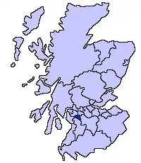
The council area of East Renfrewshire covers 513 square kilometres (198 sq mi), and has a population of around 89,000. The area contains five Category A listed buildings, comprising a 15th-century tower house, three 18th-century country houses, and a 19th-century water works.
Listed buildings
| Name | Location | Date Listed | Grid Ref. [note 1] | Geo-coordinates | Notes | LB Number [note 2] | Image |
|---|---|---|---|---|---|---|---|
| Caldwell House | Gleniffer Road, by Uplawmoor | 14 April 1971 | NS4149654157 | 55°45′17″N 4°31′38″W | 18th-century castellated house by Robert Adam | 14255 | 
|
| Capelrig House | Next to Eastwood High School, Capelrig Road, Newton Mearns | 10 June 1971 | NS5420457275 | 55°47′12″N 4°19′36″W | Georgian country house, in use as council offices | 18523 | 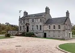
|
| Mearns Castle | Next to Mearns Castle High School, Waterfoot Road, Newton Mearns | 10 June 1971 | NS5522855342 | 55°46′11″N 4°18′33″W | 15th-century tower house, much restored and used by a local church | 18536 | 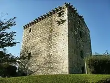
|
| Greenbank House | In National Trust site at Greenbank Garden, Flenders Road, Clarkston | 10 June 1971 | NS5612156644 | 55°46′54″N 4°17′45″W | Georgian country house, property of the National Trust for Scotland | 18537 | 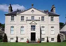
|
| Waulkmill Glen Reservoir | Dams to Darnley Country Park, between Newton Mearns and Barrhead | 5 November 2008 | NS5226557881 | 55°47′30″N 4°21′28″W | Mid 19th-century reservoir and Italianate waterworks | 51186 | 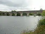
|
Notes
- Sometimes known as OSGB36, the grid reference (where provided) is based on the British national grid reference system used by the Ordnance Survey.
• "Guide to National Grid". Ordnance Survey. Retrieved 2007-12-12.
• "Get-a-map". Ordnance Survey. Retrieved 2007-12-17. - Historic Environment Scotland assign a unique alphanumeric identifier to each designated site in Scotland, for listed buildings this always begins with "LB", for example "LB12345".
References
- Scotland's Listed Buildings 2016. Historic Environment Scotland. 2016. Retrieved 20 February 2017.
External links
![]() Media related to Category A listed buildings in East Renfrewshire at Wikimedia Commons
Media related to Category A listed buildings in East Renfrewshire at Wikimedia Commons