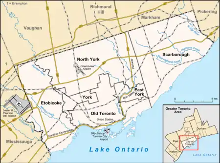
List of airports in the Greater Toronto Area
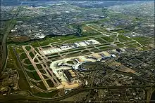
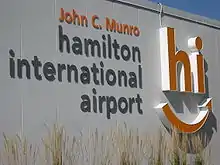
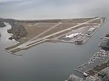
The Greater Toronto Area (GTA) contains ten airports, eight heliports, and one water aerodrome.[1][2] These aviation facilities are situated within and around Toronto and its neighbouring cities, serving airline passengers, regional air travel and commercial cargo transportation. Toronto Pearson International Airport, located mainly in Mississauga, is the busiest airport in Canada and hosts international travel with various airlines. Billy Bishop Toronto City Airport on the Toronto Islands is a regional airport, providing regular services to United States destinations. John C. Munro Hamilton International Airport in Hamilton is a base for low-cost carriers that fly domestic and transatlantic routes. The Region of Waterloo International Airport in Waterloo also offers domestic air routes. Pearson, Bishop and Hamilton combined served over 53 million passengers in 2018, making Toronto the world's 31st busiest city airport system in the world.
AHF - Armour Heights Field
BF - Baker Field
DLF - De Lesseps Field
LA - Leaside Aerodrome
LBA - Long Branch Aerodrome
MA - Maple Aerodrome
TA - Toronto Aerodrome
WA - Willowdale Airfield

Heliports and water aerodromes are mostly for private use only, mainly by institutions and medical services.
Airports

Scheduled commercial airline service
| Airport name | ICAO/TC LID/IATA | Location | Coordinates |
|---|---|---|---|
| Billy Bishop Toronto City Airport | CYTZ (YTZ) | Toronto (Toronto Islands) | 43°37′39″N 079°23′46″W |
| John C. Munro Hamilton International Airport | CYHM (YHM) | Hamilton (Mount Hope) | 43°10′25″N 079°56′06″W |
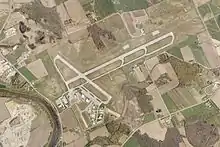
| Toronto Pearson International Airport | CYYZ (YYZ) | Mississauga | 43°40′38″N 079°37′50″W |
| Region of Waterloo International Airport | CYKF (YKF) | Woolwich | 43°27′38″N 080°22′42″W |
Other
| Airport name | ICAO/TC LID/IATA | Location | Coordinates |
|---|---|---|---|
| Brampton-Caledon Airport | CNC3 | Caledon | 43°45′37″N 079°52′30″W |
| Burlington Executive Airport | CZBA | Burlington | 43°26′30″N 079°51′01″W |
| Buttonville Municipal Airport | CYKZ (YKZ) | Buttonville, Markham | 43°51′44″N 079°22′12″W |
| Downsview Airport | CYZD (YZD) | Toronto (Downsview) | 43°44′34″N 079°27′56″W |
| Markham Airport | CNU8 | Markham | 43°56′09″N 079°15′44″W |
| Oshawa Executive Airport | CYOO (YOO) | Oshawa | 43°55′22″N 078°53′42″W |
Water aerodromes
| Airport name | ICAO/TC LID/IATA | Location | Coordinates |
|---|---|---|---|
| Billy Bishop Toronto City Water Aerodrome | CPZ9 | Toronto Islands, Toronto | 43°37′59″N 079°23′40″W |
Heliports
Other airports
Proposed airports
There is a proposal to develop a new Pickering Airport northeast of the city, to complement Pearson.[3] Versions of these tentative plans have been in existence since the early 1970s, and land for this proposed airport was expropriated by government authorities in 1972. However, continued and vociferous local opposition to the Pickering airport scheme has meant that forty years later, the airport had not moved beyond the discussion phase. In June 2013, the federal government announced the revival of the airport, but development is not expected to take place until 2027 to 2037.[4]
Historical airports
The following airports once served the area but have since been closed:
| Airport name | Location | Coordinates | Current use |
|---|---|---|---|
| Armour Heights Field | Armour Heights, Toronto | 43°44′27″N 079°25′20″W | Closed 1921 and re-developed as residential neighbourhood |
| Barker Field | Yorkdale | 43°42′54″N 079°27′22″W | Closed 1953 and now commercial property (Shell Canada gas station, Downsview Toyota dealership, Burger King, etc.) |
| De Lesseps Field | Mount Dennis Weston | 43°41′54.6″N 079°29′47.15″W | Opened in 1910 as Trethewey Airfield at a canning shed; home to de Havilland Canada in 1928 until it moved to Downsview in 1929. Site now re-developed into residential neighbourhood. |
| Downsview Airfield | Downsview | 43°44′37″N 079°27′59″W | Ceased as military airfield 1996 CFB Toronto and now Downsview Airport is a manufacturing facility for Bombardier Aviation |
| King City Airport | King City | 43°54′21″N 079°33′35″W | Bought by construction company for commercial use. Tower and parts of runway remain. |
| Leaside Aerodrome | East York | 43°42′46″N 079°21′33″W | Closed 1939 and later developed as commercial and industrial business park |
| Long Branch Aerodrome | Long Branch | 43°34′26″N 079°33′16″W | Closed 1919 and home to Lakeview Generating Station 1962–2007. Station demolished and being developed for homes, cultural and community use, as well as parkland along the waterfront. |
| Maple Airport | Vaughan | 43°50′36″N 079°31′37″W | Closed 1987 and re-developed as residential neighbourhood |
| Toronto Aerodrome (Toronto Flying Club) | Toronto (Sheppard West station) | 43°44′56″N 079°27′39″W | Closed after 1939 and later became the Sheppard West subway station |
| Willowdale Airfield | Willowdale | 43°46′11″N 079°25′36″W | Closed before 1940 and now York Cemetery, Toronto |
See also
- List of airports in the Bala, Ontario area
- List of airports in the Bracebridge area
- List of airports in the Fergus area
- List of airports in the London, Ontario area
- List of airports in the Ottawa area
- List of airports in the Parry Sound area
- List of airports in the Port Carling area
- List of airports in the Sault Ste. Marie, Ontario area
- List of airports in the Thunder Bay area
- List of cities with more than one airport
- YTO, IATA airline code for Toronto location
References
- Canada Flight Supplement. Effective 0901Z 16 July 2020 to 0901Z 10 September 2020.
- Nav Canada's Water Aerodrome Supplement. Effective 0901Z 26 March 2020 to 0901Z 22 April 2021.
- Pickering Airport Draft Plan report 2004 Archived 2008-11-15 at the Wayback Machine
- Oved, Marco Chown (11 June 2013). "Finance Minister Flaherty says Pickering airport will be operational in 15 years". Toronto Star.
External links
| By name | |
|---|---|
| By location indicator | |
| By province/territory | |
| By area | |
| National Airports System | |
| Related | |
| |