List of airports in New Brunswick

This is a list of airports in New Brunswick. It includes all Nav Canada certified and registered water and land airports, aerodromes and heliports in the Canadian province of New Brunswick.[1][2] Airports names in italics are part of the National Airports System.[3]

New Brunswick

List of airports and heliports
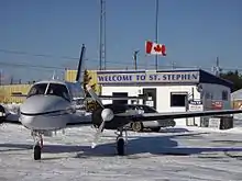
St. Stephen Airport
Saint John Airport
Greater Moncton Roméo LeBlanc International Airport
Miramichi Airport
Fredericton International Airport
Downs Gulch Aerodrome

The list is sorted by the name of the community served, click the sort buttons in the table header to switch listing order.

Community   Airport name   ICAO   TC LID   IATA   Coordinates  
BathurstBathurst AirportCZBFZBF47°37′46″N 065°44′25″W
Boston BrookBoston Brook AirportCCJ347°26′54″N 067°37′29″W
BrockwayBrockway AirportCCX345°34′00″N 067°06′00″W
BouctoucheBouctouche AerodromeCDT546°30′34″N 064°41′38″W
CharloCharlo AirportCYCLYCL47°59′27″N 066°19′49″W
ChipmanChipman AirportCCS446°08′55″N 065°54′15″W
ClearwaterClearwater AerodromeCDJ446°42′48″N 066°49′42″W
Cormier-VillageCormier AerodromeCRM446°10′51″N 064°22′32″W
Cumberland BayCumberland Bay Water AerodromeCCB746°00′21″N 065°54′19″W
DoaktownDoaktown AirportCDU646°33′09″N 066°05′38″W
Downs GulchDowns Gulch AerodromeCDV247°45′11″N 067°25′36″W
EdmundstonEdmundston AirportCYES47°29′24″N 068°28′54″W
Florenceville-BristolBristol AerodromeCDA646°27′34″N 067°33′53″W
Florenceville-BristolFlorenceville AirportCCR346°25′34″N 067°37′41″W
FrederictonFredericton International Airport (Greater Fredericton International Airport)CYFCYFC45°52′08″N 066°32′14″W
FrederictonFredericton (RCMP) HeliportCRC245°55′54″N 066°40′00″W
FrederictonScottsfield AerodromeCCF945°57′37″N 067°05′43″W
Grand FallsGrand Falls AirportCCK347°04′30″N 067°41′06″W
Grand Manan IslandGrand Manan AirportCCN244°42′48″N 066°47′47″W
HavelockHavelock AirportCCS545°59′11″N 065°18′07″W
JuniperJuniper AirportCCE346°33′48″N 067°10′06″W
KarsKars/Jenkins Cove Water AerodromeCJO345°35′38″N 065°57′25″W
Keswick RiverWeyman AirparkCCG346°02′15″N 066°51′32″W
MiramichiMiramichi AirportCYCHYCH47°00′28″N 065°26′57″W
MonctonGreater Moncton Roméo LeBlanc International Airport
(Moncton/Greater Moncton Roméo LeBlanc International Airport)
CYQMYQM46°06′44″N 064°40′43″W
MonctonMoncton/McEwen AerodromeCCG446°09′14″N 064°46′07″W
MonctonMoncton/Sailsbury HeliportCDB546°02′58″N 065°03′45″W
Oromocto (CFB Gagetown)Gagetown HeliportCYCXYCX45°50′16″N 066°26′12″W
PokemouchePokemouche AirportCDA4N/A47°42′58″N 064°52′54″W
Saint JohnSaint John AirportCYSJYSJ45°18′57″N 065°53′25″W
Saint JohnSaint John (Regional Hospital) HeliportCSN645°18′08″N 066°05′17″W
Saint-LéonardSaint-Léonard AerodromeCYSLYSL47°09′27″N 067°50′05″W
St. StephenSt. Stephen AirportCCS345°12′25″N 067°14′59″W
Sevogle RiverSevogle AirportCCM347°11′00″N 066°09′00″W
Shediac Bridge-Shediac RiverShediac Bridge AerodromeCSB546°15′17″N 064°34′36″W
SussexSussex AerodromeCCY345°41′11″N 065°32′31″W
Upper KentUpper Kent AerodromeCCH246°35′15″N 067°43′09″W
WoodstockWoodstock AerodromeCCD346°09′00″N 067°33′00″W
WoodstockWoodstock/Snokist HeliportCSN446°12′10″N 067°39′34″W

Defunct airports

Community   Airport name   ICAO   TC LID   IATA   Coordinates  
BlissvilleBlissville AirportCCH3YYS45°36′24″N 066°32′40″W
Pennfield RidgeRCAF Station Pennfield Ridge45°07′38″N 066°41′40″W
ScoudoucRCAF Station Scoudouc46°10′13″N 64°35′17″W
Saint-QuentinSaint-Quentin AerodromeCDC447°31′16″N 067°25′18″W

References

  1. Canada Flight Supplement. Effective 0901Z 16 July 2020 to 0901Z 10 September 2020.
  2. Nav Canada's Water Aerodrome Supplement. Effective 0901Z 26 March 2020 to 0901Z 22 April 2021.
  3. National Airports System
    This article is issued from Wikipedia. The text is licensed under Creative Commons - Attribution - Sharealike. Additional terms may apply for the media files.