List of islands of Wyoming

The following is a list of islands of Wyoming. Occupying 97,814 square miles (253,348 km²), the state of Wyoming is the 10th largest state in the country. It is the sixth largest state to not have an ocean coastline. Despite being landlocked, Wyoming does contain islands; the state contains 713.16 square miles (1,847 km²) of water, which is 0.72% of the state's total area.
Islands of the state of Wyoming
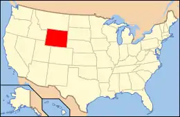
Location of Wyoming within the United States
Geography
LocationWyoming
Total islands35 named
Administration
State Wyoming
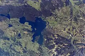
Yellowstone Lake contains several of Wyoming's islands, of which Frank Island is the largest.

Wyoming has 35 named islands, in which the majority of those are located in Jackson Lake (Grand Teton National Park) and Yellowstone Lake (Yellowstone National Park) in the northwest portion of the state. The Green River and several other rivers contain numerous river islands.

Island Body of water County Elevation Coordinates
Arizona Island[1] Jackson Lake Teton 6,811 feet (2,076 m) 43.96611°N 110.65278°W / 43.96611; -110.65278 (Arizona Island)
Badger Island[2] Jackson Lake Teton 6,775 feet (2,065 m) 43.87167°N 110.65167°W / 43.87167; -110.65167 (Badger Island)
Ball Island[3] Cottonwood Creek Teton 7,064 feet (2,153 m) 42.71855°N 110.04766°W / 42.71855; -110.04766 (Ball Island)
Big Island[4] Green River Sweetwater 6,211 feet (1,893 m) 41.75357°N 109.72597°W / 41.75357; -109.72597 (Big Island)
Boulder Island[5] Leigh Lake Teton 6,919 feet (2,109 m) 43.80000°N 110.72694°W / 43.80000; -110.72694 (Boulder Island)
Bush Island[6] Wind River Fremont 7,519 feet (2,292 m) 43.48889°N 109.57167°W / 43.48889; -109.57167 (Bush Island)
Carrington Island[7] Yellowstone Lake Teton 7,736 feet (2,358 m) 44.45639°N 110.55472°W / 44.45639; -110.55472 (Carrington Island)
Cow Island[8] Jackson Lake Teton 6,798 feet (2,072 m) 43.93194°N 110.64500°W / 43.93194; -110.64500 (Cow Island)
Dollar Island[9] Jackson Lake Teton 6,814 feet (2,077 m) 43.86972°N 110.66389°W / 43.86972; -110.66389 (Dollar Island)
Donoho Point[10] Jackson Lake Teton 6,886 feet (2,099 m) 43.84639°N 110.62917°W / 43.84639; -110.62917 (Donoho Point)
Dot Island[11] Yellowstone Lake Teton 7,746 feet (2,361 m) 44.45194°N 110.40972°W / 44.45194; -110.40972 (Dot Island)
Elk Island[12] Jackson Lake Teton 6,873 feet (2,095 m) 43.86139°N 110.67750°W / 43.86139; -110.67750 (Elk Island)
Ferry Island[13] Green River Sublette 6,745 feet (2,056 m) 42.52361°N 110.05583°W / 42.52361; -110.05583 (Ferry Island)
Frank Island[14] Yellowstone Lake Teton 7,795 feet (2,376 m) 44.42528°N 110.36778°W / 44.42528; -110.36778 (Frank Island)
Freezeout Island[15] Green River Sweetwater 6,253 feet (1,906 m) 41.84333°N 109.78861°W / 41.84333; -109.78861 (Freezeout Island)
Grassy Island[16] Jackson Lake Teton 6,791 feet (2,070 m) 43.85917°N 110.73167°W / 43.85917; -110.73167 (Grassy Island)
Indian Island[17] Jackson Lake Teton 6,778 feet (2,066 m) 43.96111°N 110.65917°W / 43.96111; -110.65917 (Indian Island)
Johnson Island[18] North Platte River Carbon 6,640 feet (2,020 m) 41.57333°N 106.96778°W / 41.57333; -106.96778 (Johnson Island)
Long Island[19] Green River Sublette 6,650 feet (2,030 m) 42.38611°N 110.11583°W / 42.38611; -110.11583 (Long Island)
Mack Island[20] New Fork River Sublette 6,870 feet (2,090 m) 42.64717°N 109.83959°W / 42.64717; -109.83959 (Mack Island)
Marie Island[21] Jackson Lake Teton 6,772 feet (2,064 m) 43.84667°N 110.65528°W / 43.84667; -110.65528 (Marie Island)
Molly Islands[22][23] Yellowstone Lake Teton 7,739 feet (2,359 m) 44.31361°N 110.26500°W / 44.31361; -110.26500 (Molly Islands)
Moose Island[24] Jackson Lake Teton 6,778 feet (2,066 m) 43.92500°N 110.65028°W / 43.92500; -110.65028 (Moose Island)
Mullison Island[25] North Platte River Carbon 6,778 feet (2,066 m) 41.46583°N 106.80806°W / 41.46583; -106.80806 (Mullison Island)
Mystic Isle[26] Leigh Lake Teton 6,919 feet (2,109 m) 43.81972°N 110.72440°W / 43.81972; -110.72440 (Mystic Isle)
Oxbow Bend[27] Snake River Teton 6,735 feet (2,053 m) 43.86278°N 110.54806°W / 43.86278; -110.54806 (Oxbow Bend)
Peale Island[28] Yellowstone Lake Teton 7,743 feet (2,360 m) 44.28806°N 110.31639°W / 44.28806; -110.31639 (Peale Island)
Pelican Roost[29] Yellowstone Lake Teton 7,736 feet (2,358 m) 44.52222°N 110.30556°W / 44.52222; -110.30556 (Pelican Roost)
Sheffield Island[30] Jackson Lake Teton 6,804 feet (2,074 m) 43.87694°N 110.65500°W / 43.87694; -110.65500 (Sheffield Island)
Stevenson Island[31] Yellowstone Lake Teton 7,762 feet (2,366 m) 44.51528°N 110.38444°W / 44.51528; -110.38444 (Stevenson Island)
Tarters Island[32] Green River Sublette 6,709 feet (2,045 m) 42.48389°N 110.07667°W / 42.48389; -110.07667 (Tarters Island)
Telephone Island[33] Green River Sweetwater 6,227 feet (1,898 m) 41.78667°N 109.76694°W / 41.78667; -109.76694 (Telephone Island)
Treasure Island[34] Bechler River Teton 6,713 feet (2,046 m) 44.24306°N 110.94000°W / 44.24306; -110.94000 (Treasure Island)
Willow Island[35] Green River Sublette 7,254 feet (2,211 m) 42.88639°N 109.85472°W / 42.88639; -109.85472 (Willow Island)

References

  1. "Arizona Island". Geographic Names Information System. United States Geological Survey.
  2. "Badger Island". Geographic Names Information System. United States Geological Survey.
  3. "Ball Island". Geographic Names Information System. United States Geological Survey.
  4. "Big Island". Geographic Names Information System. United States Geological Survey.
  5. "Boulder Island". Geographic Names Information System. United States Geological Survey.
  6. "Bush Island". Geographic Names Information System. United States Geological Survey.
  7. "Carrington Island". Geographic Names Information System. United States Geological Survey.
  8. "Cow Island". Geographic Names Information System. United States Geological Survey.
  9. "Dollar Island". Geographic Names Information System. United States Geological Survey.
  10. "Donoho Island". Geographic Names Information System. United States Geological Survey.
  11. "Dot Island". Geographic Names Information System. United States Geological Survey.
  12. "Elk Island". Geographic Names Information System. United States Geological Survey.
  13. "Ferry Island". Geographic Names Information System. United States Geological Survey.
  14. "Frank Island". Geographic Names Information System. United States Geological Survey.
  15. "Freezeout Island". Geographic Names Information System. United States Geological Survey.
  16. "Grassy Island". Geographic Names Information System. United States Geological Survey.
  17. "Indian Island". Geographic Names Information System. United States Geological Survey.
  18. "Johnson Island". Geographic Names Information System. United States Geological Survey.
  19. "Long Island". Geographic Names Information System. United States Geological Survey.
  20. "Mack Island". Geographic Names Information System. United States Geological Survey.
  21. "Marie Island". Geographic Names Information System. United States Geological Survey.
  22. "Molly Island". Geographic Names Information System. United States Geological Survey.
  23. "Molly Islands". Geographic Names Information System. United States Geological Survey.
  24. "Moose Island". Geographic Names Information System. United States Geological Survey.
  25. "Mullison Island". Geographic Names Information System. United States Geological Survey.
  26. "Mystic Isle". Geographic Names Information System. United States Geological Survey.
  27. "Oxbow Bends". Geographic Names Information System. United States Geological Survey.
  28. "Peale Island". Geographic Names Information System. United States Geological Survey.
  29. "Pelican Roost". Geographic Names Information System. United States Geological Survey.
  30. "Sheffield Island". Geographic Names Information System. United States Geological Survey.
  31. "Stevenson Island". Geographic Names Information System. United States Geological Survey.
  32. "Tarters Island". Geographic Names Information System. United States Geological Survey.
  33. "Telephone Island". Geographic Names Information System. United States Geological Survey.
  34. "Treasure Island". Geographic Names Information System. United States Geological Survey.
  35. "Willow Island". Geographic Names Information System. United States Geological Survey.
This article is issued from Wikipedia. The text is licensed under Creative Commons - Attribution - Sharealike. Additional terms may apply for the media files.