Malden Inn
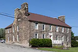
The 1820s Malden Inn (also sometimes as The Kreppsville Inn[2]) and John Krepps Tavern[3] is a historic building in the unincorporated bedroom community of Malden, Pennsylvania at the junction of South Malden Road[lower-alpha 1] and Old U.S. Route 40 (US40), the historic Cumberland Pike. The Inn's Malden location (present-day borough of Centerville, PA) along the western part of the Amerindian trail known as Nemacolin's Path transformed into a wagon road linking the river ford[lower-alpha 2] between Brownsville–West Brownsville with the former frontier towns of Washington, Pennsylvania and Wheeling, West Virginia, where the Emigrant Trail then allowed an easy crossing the Ohio River. The Inn had a good commercial site astride the old National Pike (U.S. Route 40 before the 1960s highway construction project) about three miles west of the long climb up from West Brownsville and Denbo Heights, PA being located at the former junction[lower-alpha 3] of Malden Road connecting northwards to Coal Center and California situated about half-the-way to Centerville from the Brownsville ford and the ferry terminus below Blainsburg just North-northeast of West Brownsville.[lower-alpha 4]
Malden Inn | |
 Malden Inn in August 2014 | |
  | |
| Nearest city | midway Centerville and West Brownsville, Pennsylvania |
|---|---|
| Coordinates | 40°2′15″N 79°55′50″W |
| Area | 1 acre (0.40 ha) |
| Built | 1820 |
| Architectural style | Georgian |
| NRHP reference No. | 74001805[1] |
| Added to NRHP | January 24, 1974 |
It is designated as a historic residential landmark/farmstead by the Washington County History & Landmarks Foundation.[4]
Notes
- South Malden Road is a short street 'rump' once connected to Malden Road to California, PA, but now sundered by the four lanes of new US40. Malden Road was given a new curved ramp and makes a junction with the two westbound lanes of US40, while South Malden Road connects with the two eastbound lanes.
- Using GoogleEarth or Map software with an option to display satellite imagery, the shallows upriver & South of West Brownsville are clearly visible. The West Brownsville bridges (There were several, the latest was built in 1919.) upstream of Dunbar Creek's mouth is below the historic river ford.
- Malden Road once zigged a few hundred yards along the traverse 'overwritten' by the four lanes of the new U.S. Route 40 (ca. 1960ish) highways' path. Examining a digital map at 40.039717, -79.927472 will show a steep local street descending to the eastbound lanes of US40, as does the truncated Malden Road (renamed 'Malden Place') stub street running along the side entrance to the Malden Inn. Opposite the steep street, the revised path of Malden road ties into the westbound lanes of US40 on a sweeping ramp curving left. This curve used to be nearly straight and dipped much lower, as a satellite-view-mode inspection of the rear yard of the house to the northeast will demonstrate.
- Map viewing by many services by navigating to West Brownsville, PA, one can still see Blaine's Road connecting north to California Road. Blainsburg, Pennsylvania is the small cluster of housing streets on the upland above the narrow tongue shaped shelf forming the flat bottom land of West Brownsville.
References
- "National Register Information System". National Register of Historic Places. National Park Service. March 13, 2009.
- "The Malden Inn". Washington County History & Landmarks Foundation.
The inn, built by Krepps who envisioned a surrounding village, was also known as the Kreppsville Inn.
- See this photo: 1963 survey of historic places
- "Malden Inn". Landmark Registry - Residential Landmark/Farmstead. Washington County History & Landmarks Foundation. 2008. Archived from the original on 2012-03-14. Retrieved 2010-11-08.

