National Register of Historic Places listings in Lehigh County, Pennsylvania
This is a list of the National Register of Historic Places listings in Lehigh County, Pennsylvania.
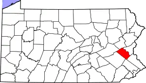
Location of Lehigh County in Pennsylvania
This is intended to be a complete list of the properties and districts on National Register of Historic Places in Lehigh County, Pennsylvania. The locations of National Register properties and districts for which the latitude and longitude coordinates are included below, may be seen in a map.[1]
There are 54 properties and districts listed on the National Register in the county. One site is further designated as a National Historic Landmark. Another property was once listed but has been removed.
- This National Park Service list is complete through NPS recent listings posted January 29, 2021.[2]
Current listings
| [3] | Name on the Register | Image | Date listed[4] | Location | Municipality | Description |
|---|---|---|---|---|---|---|
| 1 | Allentown Masonic Temple | 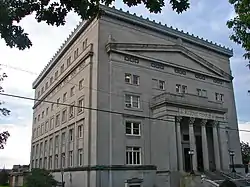 Allentown Masonic Temple |
May 5, 2004 (#04000402) |
1524 West Linden Street 40°35′55″N 75°29′25″W |
Allentown | |
| 2 | Allentown National Bank | 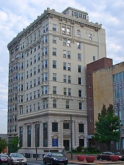 Allentown National Bank |
December 28, 2005 (#05001490) |
13–17 N. 7th Street 40°36′17″N 75°28′17″W |
Allentown | |
| 3 | Americus Hotel | 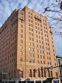 Americus Hotel |
August 23, 1984 (#84003454) |
541 Hamilton Street 40°36′10″N 75°28′12″W |
Allentown | |
| 4 | Bethlehem Armory | 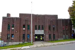 Bethlehem Armory |
November 14, 1991 (#91001693) |
301 Prospect Street 40°37′09″N 75°23′16″W |
Bethlehem | |
| 5 | Biery's Port Historic District | 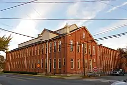 Biery's Port Historic District |
August 9, 1984 (#84003457) |
Roughly bounded by Pineapple, Front, Race, and Mulberry Streets 40°38′57″N 75°28′04″W |
Catasauqua | |
| 6 | Bogert Covered Bridge | 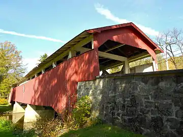 Bogert Covered Bridge |
December 1, 1980 (#80003552) |
South of Allentown on Legislative Route 39016 in Little Lehigh Park 40°34′08″N 75°30′17″W |
Allentown | |
| 7 | Bridge in Heidelberg Township | 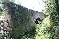 Bridge in Heidelberg Township |
June 22, 1988 (#88000765) |
Legislative Route 39110 over a branch of Jordan Creek 40°42′03″N 75°42′37″W |
Heidelberg Township | |
| 8 | Burnside Plantation |  Burnside Plantation |
May 2, 1990 (#90000705) |
Schoenersville Road 2 miles (3.2 km) southeast of its junction with Easton Avenue 40°37′51″N 75°23′22″W |
Bethlehem | |
| 9 | Catasauqua Residential Historic District |  Catasauqua Residential Historic District |
May 10, 1984 (#84003465) |
Roughly bounded by Howertown Road, Railroad Avenue, Oak and Bridge Streets 40°39′19″N 75°28′25″W |
Catasauqua | |
| 10 | Centennial Bridge | .jpg.webp) Centennial Bridge |
June 22, 1988 (#88000772) |
Station Avenue over Saucon Creek 40°31′43″N 75°23′31″W |
Center Valley | |
| 11 | Central Bethlehem Historic District | 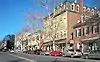 Central Bethlehem Historic District |
May 5, 1972 (#72001131) |
Bounded by Main, Nevada, and East Broad Streets, and the river 40°37′06″N 75°22′56″W |
Bethlehem | Extends into Northampton County |
| 12 | Cold Spring Bridge |  Cold Spring Bridge |
June 22, 1988 (#88000874) |
2nd Street over Spring Creek 40°42′03″N 75°31′01″W |
North Whitehall and Whitehall Townships | |
| 13 | Coopersburg Historic District |  Coopersburg Historic District |
April 26, 1982 (#82003798) |
Main Street and Pennsylvania Route 309 40°30′32″N 75°23′23″W |
Coopersburg | |
| 14 | Coplay Cement Company Kilns | 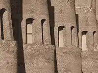 Coplay Cement Company Kilns |
September 2, 1980 (#80003556) |
North 2nd Street 40°40′34″N 75°29′42″W |
Coplay | |
| 15 | Dent Hardware Company Factory Complex | 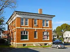 Dent Hardware Company Factory Complex |
August 21, 1986 (#86001772) |
1101 3rd Street, Fullerton 40°38′24″N 75°28′30″W |
Whitehall Township | |
| 16 | Dillingersville Union School and Church |  Dillingersville Union School and Church |
October 25, 1979 (#79002290) |
East of Zionsville on Zionsville Road 40°28′26″N 75°29′17″W |
Lower Milford Township | |
| 17 | Dime Savings and Trust Company | 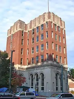 Dime Savings and Trust Company |
January 3, 1985 (#85000036) |
12 North 7th Street 40°36′08″N 75°28′22″W |
Allentown | |
| 18 | Dorneyville Crossroad Settlement |  Dorneyville Crossroad Settlement |
December 7, 1977 (#77001172) |
South of Allentown at the junction of U.S. Route 222 and Pennsylvania Route 29 40°34′48″N 75°31′19″W |
South Whitehall Township | |
| 19 | Jacob Ehrenhardt Jr. House |  Jacob Ehrenhardt Jr. House |
November 7, 2003 (#03001123) |
55 South Keystone Avenue 40°32′23″N 75°29′11″W |
Emmaus | |
| 20 | Fireman's Drinking Fountain | 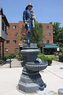 Fireman's Drinking Fountain |
November 9, 1981 (#81000551) |
Main Street 40°45′06″N 75°36′48″W |
Slatington | |
| 21 | Fountain Hill Historic District |  Fountain Hill Historic District |
April 21, 1988 (#88000450) |
Roughly bounded by Brighton, Wyandotte, W. 4th, and Seminole Streets, and Delaware Avenue 40°36′40″N 75°23′10″W |
Bethlehem | Extends into Northampton County |
| 22 | Frantz's Bridge |  Frantz's Bridge |
June 22, 1988 (#88000771) |
Legislative Route 39060 over Jordan Creek 40°39′03″N 75°39′02″W |
Lowhill Township | Replaced with a concrete bridge in 2011 |
| 23 | Gauff-Roth House | 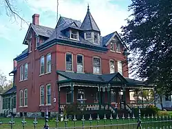 Gauff-Roth House |
September 5, 1985 (#85001966) |
427–443 Auburn Street 40°35′46″N 75°27′52″W |
Allentown | |
| 24 | Geiger Covered Bridge | 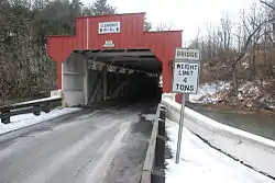 Geiger Covered Bridge |
December 1, 1980 (#80003558) |
Southeast of Schencksville on Township 681 40°38′46″N 75°37′00″W |
North Whitehall Township | |
| 25 | Haines Mill | 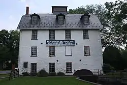 Haines Mill |
September 11, 1981 (#81000548) |
Walnut Street and Main Boulevard 40°35′06″N 75°31′56″W |
South Whitehall Township | |
| 26 | Helfrich's Springs Grist Mill | 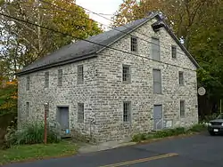 Helfrich's Springs Grist Mill |
October 14, 1977 (#77001174) |
West of Fullerton on Mickley Road 40°37′31″N 75°29′29″W |
Whitehall Township | |
| 27 | High German Evangelical Reformed Church | 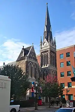 High German Evangelical Reformed Church |
July 28, 1983 (#83002259) |
620 Hamilton Street 40°36′09″N 75°28′14″W |
Allentown | Also known as Zion Reformed Church |
| 28 | Hotel Sterling | 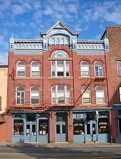 Hotel Sterling |
May 3, 1984 (#84003469) |
343–345 Hamilton Street 40°36′19″N 75°27′43″W |
Allentown | |
| 29 | Kemmerer House |  Kemmerer House |
September 14, 1977 (#77001173) |
3 Iroquois Street 40°32′54″N 75°29′57″W |
Emmaus | |
| 30 | Frederick and Catherine Leaser Farm | 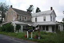 Frederick and Catherine Leaser Farm |
January 14, 2004 (#03001420) |
7654 Leaser Road 40°40′32″N 75°50′47″W |
Lynn Township | Homestead of Frederick Leaser, who transported the Liberty Bell to Zion Reformed Church in 1777 |
| 31 | Lehigh Canal | 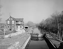 Lehigh Canal |
August 15, 1980 (#80003553) |
Walnutport to Allentown Section 40°42′08″N 75°31′52″W |
Allentown | Extends into Northampton County |
| 32 | Lehigh Canal; Allentown to Hopeville Section |  Lehigh Canal; Allentown to Hopeville Section |
December 17, 1979 (#79002307) |
Along the Lehigh River 40°36′55″N 75°24′52″W |
Allentown | |
| 33 | Linden Grove Pavilion |  Linden Grove Pavilion |
November 30, 1979 (#79002289) |
Linden and South Main Streets 40°30′18″N 75°23′35″W |
Coopersburg | |
| 34 | Lock Ridge Furnace Complex | 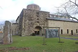 Lock Ridge Furnace Complex |
September 11, 1981 (#81000547) |
Franklin and Church Streets 40°30′32″N 75°35′39″W |
Alburtis | |
| 35 | Manasses Guth Covered Bridge | .png.webp) Manasses Guth Covered Bridge |
December 1, 1980 (#80003559) |
West of Greenawalds on Township 602 40°37′42″N 75°33′13″W |
South Whitehall Township | |
| 36 | Albertus L. Meyers Bridge | 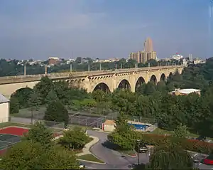 Albertus L. Meyers Bridge |
June 22, 1988 (#88000870) |
8th Street over Little Lehigh and Railroad Streets 40°35′45″N 75°28′16″W |
Allentown | |
| 37 | Mount Airy Historic District |  Mount Airy Historic District |
May 9, 1988 (#88000453) |
Roughly Prospect Avenue between 15th and 8th Avenues 40°37′12″N 75°24′09″W |
Bethlehem | |
| 38 | Neuweiler Brewery | 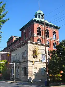 Neuweiler Brewery |
June 27, 1980 (#80003554) |
401 North Front Street 40°36′40″N 75°27′29″W |
Allentown | |
| 39 | Old Lehigh County Courthouse | 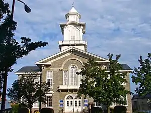 Old Lehigh County Courthouse |
September 11, 1981 (#81000550) |
5th and Hamilton Streets 40°36′13″N 75°28′04″W |
Allentown | |
| 40 | Rex Covered Bridge |  Rex Covered Bridge |
December 1, 1980 (#80003560) |
South of Schencksville on Township 593 40°38′05″N 75°36′47″W |
North Whitehall Township | |
| 41 | Rodale Organic Gardening Experimental Farm | 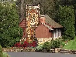 Rodale Organic Gardening Experimental Farm |
May 12, 1999 (#99000515) |
2056 Minesite Road 40°33′17″N 75°31′20″W |
Lower Macungie Township | |
| 42 | Schlicher Covered Bridge | 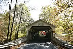 Schlicher Covered Bridge |
December 1, 1980 (#80003555) |
Legislative Route 39058 near Allentown 40°39′42″N 75°37′38″W |
North Whitehall Township | |
| 43 | George F. Schlicher Hotel |  George F. Schlicher Hotel |
May 7, 1992 (#92000396) |
105–107 South Main Street 40°30′43″N 75°36′12″W |
Alburtis | |
| 44 | Schubert-Graber Log-Post Shop | 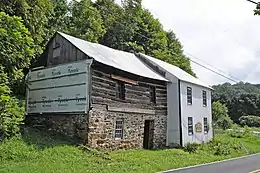 Schubert-Graber Log-Post Shop |
February 4, 2019 (#100003247) |
6561 Powder Valley Rd. 40°28′23″N 75°31′27″W |
Upper Milford Township | |
| 45 | Shelter House | 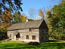 Shelter House |
February 17, 1978 (#78002426) |
South 4th Street 40°31′50″N 75°29′06″W |
Emmaus | |
| 46 | Slatington Historic District |  Slatington Historic District |
August 11, 2004 (#04000839) |
Roughly bounded by Ridge Alley, Chesnut Street, Railroad Street, Kern Street, Hill Alley, 5th Street, and Dowell 40°44′54″N 75°36′43″W |
Slatington | |
| 47 | George Taylor House | 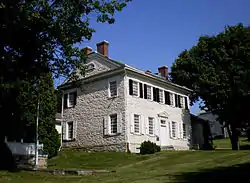 George Taylor House |
July 17, 1971 (#71000709) |
Front Street 40°38′52″N 75°27′59″W |
Catasauqua | |
| 48 | Trout Hall |  Trout Hall |
November 14, 1978 (#78002425) |
414 Walnut Street 40°36′09″N 75°27′50″W |
Allentown | |
| 49 | Troxell-Steckel House |  Troxell-Steckel House |
June 27, 1980 (#80003557) |
4229 Reliance Street 40°40′32″N 75°32′08″W |
Egypt | |
| 50 | Vigilant Fire Company Firemen's Monument | 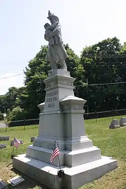 Vigilant Fire Company Firemen's Monument |
August 11, 2004 (#04000838) |
Union Cemetery, west side of Pennsylvania Route 873, approximately 1⁄3 mile (0.5 km) south of Slatington 40°44′23″N 75°36′49″W |
Washington Township | |
| 51 | Valentine Weaver House |  Valentine Weaver House |
June 28, 1984 (#84003482) |
146 South Church Street 40°30′40″N 75°33′21″W |
Macungie | |
| 52 | Wehr Covered Bridge |  Wehr Covered Bridge |
December 1, 1980 (#80003561) |
West of Greenawald on Township 597 40°34′08″N 75°30′17″W |
South Whitehall Township | |
| 53 | Zollinger-Harned Company Building | 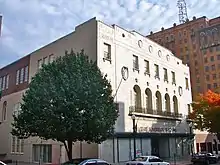 Zollinger-Harned Company Building |
December 17, 1979 (#79002288) |
605–613 Hamilton Mall and 14016 North 6th Street 40°36′10″N 75°28′14″W |
Allentown |
Former listings
| [3] | Name on the Register | Image | Date listed | Date removed | Location | Municipality | Summary |
|---|---|---|---|---|---|---|---|
| 1 | Bridge in Lynn Township | 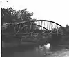 Bridge in Lynn Township |
Unspecified (#88000822) | March 21, 2003 | Legislative Route 39112 over Ontelaunee Creek |
Steinsville | |
| 2 | Lehigh County Prison | September 11, 1981 (#81000549) | August 24, 1998 | 4th and Linden Sts. |
Allentown | ||
| 3 | Nonnemaker House |  Nonnemaker House |
1973 (#73002281) | 1973 | 301 S. Lehigh St. |
Allentown | |
| 36 | Martin Tower | 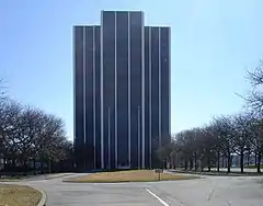 Martin Tower |
June 28, 2010 (#10000401) | May 19, 2019 | 1170 8th Ave. 40°37′54″N 75°23′40″W |
Bethlehem |
See also
| Wikimedia Commons has media related to National Register of Historic Places in Lehigh County, Pennsylvania. |
References
- The latitude and longitude information provided in this table was derived originally from the National Register Information System, which has been found to be fairly accurate for about 99% of listings. Some locations in this table may have been corrected to current GPS standards.
- "National Register of Historic Places: Weekly List Actions". National Park Service, United States Department of the Interior. Retrieved on January 29, 2021.
- Numbers represent an alphabetical ordering by significant words. Various colorings, defined here, differentiate National Historic Landmarks and historic districts from other NRHP buildings, structures, sites or objects.
- The eight-digit number below each date is the number assigned to each location in the National Register Information System database, which can be viewed by clicking the number.
| Topics | 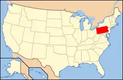 | |
|---|---|---|
| Lists by county |
| |
| Lists by city | ||
| Other lists | ||
| ||
Municipalities and communities of Lehigh County, Pennsylvania, United States | ||
|---|---|---|
| Cities | | |
| Boroughs | ||
| Townships | ||
| CDPs | ||
| Unincorporated communities |
| |
| Footnotes | ‡This populated place also has portions in an adjacent county or counties | |
| ||
This article is issued from Wikipedia. The text is licensed under Creative Commons - Attribution - Sharealike. Additional terms may apply for the media files.