National Register of Historic Places listings in Lackawanna County, Pennsylvania
This is a list of the National Register of Historic Places listings in Lackawanna County, Pennsylvania.
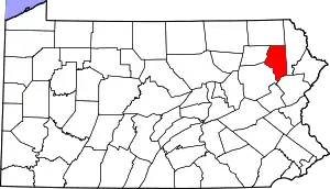
Location of Lackawanna County in Pennsylvania
This is intended to be a complete list of the properties and districts on the National Register of Historic Places in Lackawanna County, Pennsylvania, United States. The locations of National Register properties and districts for which the latitude and longitude coordinates are included below, may be seen in a map.[1]
There are 35 properties and districts listed on the National Register in the county. One site is further designated as a National Historic Landmark and another is designated as a National Historic Site.
- This National Park Service list is complete through NPS recent listings posted January 29, 2021.[2]
Current listings
| [3] | Name on the Register | Image | Date listed[4] | Location | City or town | Description |
|---|---|---|---|---|---|---|
| 1 | Ad-Lin Building |  Ad-Lin Building |
November 5, 1987 (#87001969) |
600 Linden Street 41°24′29″N 75°39′41″W |
Scranton | |
| 2 | Albright Memorial Building |  Albright Memorial Building |
May 22, 1978 (#78002411) |
North Washington Avenue and Vine Street 41°24′39″N 75°39′35″W |
Scranton | |
| 3 | Carbondale City Hall and Courthouse |  Carbondale City Hall and Courthouse |
January 6, 1983 (#83002248) |
One North Main Street 41°34′20″N 75°30′13″W |
Carbondale | |
| 4 | Joseph Cassese House |  Joseph Cassese House |
October 24, 1997 (#97001258) |
1000 Clay Avenue 41°24′47″N 75°38′48″W |
Scranton | |
| 5 | Central Railroad of New Jersey Freight Station | 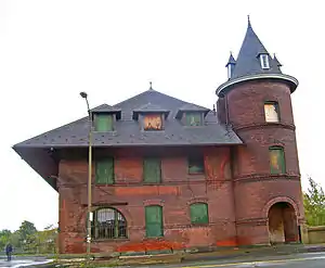 Central Railroad of New Jersey Freight Station |
August 1, 1979 (#79002250) |
602 West Lackawanna Avenue 41°24′42″N 75°40′16″W |
Scranton | |
| 6 | Century Club of Scranton |  Century Club of Scranton |
March 28, 1996 (#96000323) |
612 Jefferson Avenue 41°24′42″N 75°39′21″W |
Scranton | |
| 7 | Delaware, Lackawanna and Western Railroad Station |  Delaware, Lackawanna and Western Railroad Station |
December 6, 1977 (#77001170) |
Lackawanna and Jefferson Avenues 41°24′19″N 75°39′43″W |
Scranton | |
| 8 | Delaware, Lackawanna and Western Railroad Yard-Dickson Manufacturing Co. Site |  Delaware, Lackawanna and Western Railroad Yard-Dickson Manufacturing Co. Site |
November 21, 1990 (#90001739) |
Roughly bounded by Cliff Street, Lackawanna Avenue, Mattes Avenue, River Street and the Lackawanna River 41°24′23″N 75°40′09″W |
Scranton | |
| 9 | Dickson Works |  Dickson Works |
May 14, 1979 (#79002251) |
225 Vine Street 41°24′49″N 75°39′45″W |
Scranton | |
| 10 | Dime Bank Building | 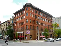 Dime Bank Building |
July 14, 1978 (#78002412) |
Wyoming Avenue and Spruce Street 41°24′30″N 75°39′56″W |
Scranton | |
| 11 | Finch Building |  Finch Building |
June 14, 1976 (#76001644) |
424 Wyoming Avenue 41°24′42″N 75°39′43″W |
Scranton | |
| 12 | First Church of Christ, Scientist | 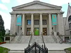 First Church of Christ, Scientist |
May 9, 1988 (#88000467) |
520 Vine Street 41°24′32″N 75°39′38″W |
Scranton | |
| 13 | Florence Apartments |  Florence Apartments |
January 5, 1984 (#84003412) |
643 Adams Avenue 41°24′46″N 75°39′24″W |
Scranton | |
| 14 | Grand Army of the Republic Building | 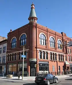 Grand Army of the Republic Building |
May 17, 1984 (#84003416) |
303 Linden Street 41°24′39″N 75°39′55″W |
Scranton | |
| 15 | Harrison Avenue Bridge |  Harrison Avenue Bridge |
June 22, 1988 (#88000767) |
Legislative Route 5 over Legislative Route 35009, Par–Roaring Brook and railroad 41°24′00″N 75°39′06″W |
Scranton | |
| 16 | Lackawanna Avenue Commercial Historic District | 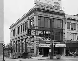 Lackawanna Avenue Commercial Historic District |
November 10, 1983 (#83004215) |
Roughly bounded by Adams, Franklin, Bogart Place, and Spruce Streets 41°24′27″N 75°39′55″W |
Scranton | |
| 17 | Lackawanna County Courthouse and John Mitchell Monument |  Lackawanna County Courthouse and John Mitchell Monument |
November 5, 1997 (#97001257) |
Bounded by Washington Avenue, Linden Street, Adams Avenue, and Spruce Street 41°24′29″N 75°39′46″W |
Scranton | |
| 18 | Lackawanna Iron and Coal Company Furnace | 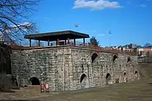 Lackawanna Iron and Coal Company Furnace |
September 6, 1991 (#91001126) |
159 Cedar Avenue 41°24′16″N 75°39′45″W |
Scranton | |
| 19 | Lackawanna Mills and Scranton Button Historic District |  Lackawanna Mills and Scranton Button Historic District |
May 1, 2017 (#100000942) |
Bounded by Cedar & Remington Aves., Cherry & Brook Sts. 41°23′41″N 75°40′30″W |
Scranton | |
| 20 | James Madison School |  James Madison School |
June 24, 2009 (#09000463) |
528 Quincy Avenue 41°24′30″N 75°39′11″W |
Scranton | Educational Resources of Pennsylvania MPS |
| 21 | Masonic Temple and Scottish Rite Cathedral |  Masonic Temple and Scottish Rite Cathedral |
November 7, 1997 (#97001259) |
416–420 North Washington Avenue 41°24′39″N 75°39′38″W |
Scranton | |
| 22 | Municipal Building and Central Fire Station, 340 |  Municipal Building and Central Fire Station, 340 |
September 11, 1981 (#81000544) |
North Washington Avenue and 518 Mulberry Street 41°24′36″N 75°39′41″W |
Scranton | |
| 23 | North Scranton Junior High School |  North Scranton Junior High School |
September 24, 1999 (#99001197) |
1539 North Main Avenue 41°25′42″N 75°38′51″W |
Scranton | |
| 24 | Terence V. Powderly House | 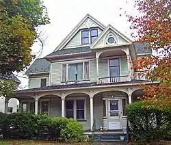 Terence V. Powderly House |
October 15, 1966 (#66000667) |
614 North Main Street 41°25′07″N 75°40′30″W |
Scranton | |
| 25 | St. Peter's Cathedral Complex | 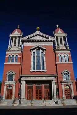 St. Peter's Cathedral Complex |
July 19, 1976 (#76001645) |
315 Wyoming Avenue 41°24′38″N 75°39′50″W |
Scranton | |
| 26 | Scranton Armory | 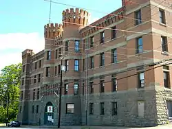 Scranton Armory |
December 22, 1989 (#89002081) |
900 Adams Avenue 41°24′55″N 75°39′10″W |
Scranton | |
| 27 | Scranton Chamber of Commerce Building |  Scranton Chamber of Commerce Building |
September 8, 2011 (#11000647) |
426 Mulberry Street 41°24′38″N 75°39′42″W |
Scranton | |
| 28 | Scranton Lace Company | 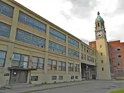 Scranton Lace Company |
April 16, 2012 (#12000221) |
1315 Meylert St. 41°25′36″N 75°39′34″W |
Scranton | |
| 29 | Silkman House |  Silkman House |
December 18, 1978 (#78002413) |
2006 North Main Avenue 41°26′17″N 75°39′21″W |
Scranton | |
| 30 | Steamtown National Historic Site |  Steamtown National Historic Site |
October 30, 1986 (#01000282) |
150 South Washington Avenue 41°24′26″N 75°40′12″W |
Scranton | |
| 31 | Stoehr and Fister Building |  Stoehr and Fister Building |
November 25, 2019 (#100004662) |
200 Adams Ave. 41°24′26″N 75°39′44″W |
Scranton | |
| 32 | Tripp Family Homestead |  Tripp Family Homestead |
June 19, 1972 (#72001126) |
1101 North Main Avenue 41°25′36″N 75°40′12″W |
Scranton | |
| 33 | U.S. Post Office and Court House | 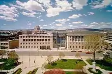 U.S. Post Office and Court House |
January 4, 2018 (#100001953) |
235 N Washington Ave. 41°24′31″N 75°39′47″W |
Scranton | AKA the William J. Nealon Federal Building and United States Courthouse |
| 34 | Waverly Historic District | 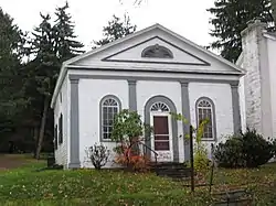 Waverly Historic District |
August 20, 2004 (#04000884) |
Roughly centered on Academy Street and Abington Road, including Carbondale Road and Beech, Cole, Church, and Dearborn Streets 41°31′38″N 75°42′18″W |
Waverly Township | |
| 35 | Roger Williams Public School No. 10 | 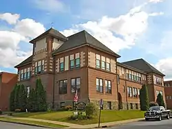 Roger Williams Public School No. 10 |
June 13, 1997 (#97000520) |
901 Prospect Avenue 41°23′38″N 75°39′57″W |
Scranton |
Former listings
| [3] | Name on the Register | Image | Date listed | Date removed | Location | City or town | Summary |
|---|---|---|---|---|---|---|---|
| 1 | James L. Crawford House | February 8, 1980 (#80003505) | March 9, 1992 | 313 Monroe Ave. |
Scranton | ||
| 2 | Dalton House | May 22, 1978 (#78002410) | November 11, 2002 | East Main Street |
Dalton | ||
| 3 | Delaware and Hudson Canal Gravity Railroad Shops | November 30, 1978 (#78002409) | September 15, 1987 | 91 North Main Street |
Carbondale | ||
| 4 | Watkins-Maxey House | June 27, 1980 (#80003506) | June 27, 1986 | 520 Monroe Avenue |
Scranton |
See also
| Wikimedia Commons has media related to National Register of Historic Places in Lackawanna County, Pennsylvania. |
References
- The latitude and longitude information provided in this table was derived originally from the National Register Information System, which has been found to be fairly accurate for about 99% of listings. Some locations in this table may have been corrected to current GPS standards.
- "National Register of Historic Places: Weekly List Actions". National Park Service, United States Department of the Interior. Retrieved on January 29, 2021.
- Numbers represent an alphabetical ordering by significant words. Various colorings, defined here, differentiate National Historic Landmarks and historic districts from other NRHP buildings, structures, sites or objects.
- The eight-digit number below each date is the number assigned to each location in the National Register Information System database, which can be viewed by clicking the number.
| Topics | 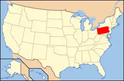 | |
|---|---|---|
| Lists by county |
| |
| Lists by city | ||
| Other lists | ||
| ||
Municipalities and communities of Lackawanna County, Pennsylvania, United States | ||
|---|---|---|
| Cities | | |
| Boroughs | ||
| Townships | ||
| CDPs | ||
| Other unincorporated communities | ||
| ||
This article is issued from Wikipedia. The text is licensed under Creative Commons - Attribution - Sharealike. Additional terms may apply for the media files.