National Register of Historic Places listings in Monroe County, Pennsylvania
This is a list of the National Register of Historic Places listings in Monroe County, Pennsylvania.
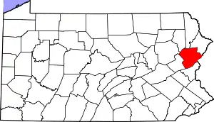
Location of Monroe County in Pennsylvania
This is intended to be a complete list of the properties and districts on the National Register of Historic Places in Monroe County, Pennsylvania, United States. The locations of National Register properties and districts for which the latitude and longitude coordinates are included below, may be seen in a map.[1]
There are 20 properties and districts listed on the National Register in the county. Another 3 properties were once listed but have been removed.
- This National Park Service list is complete through NPS recent listings posted January 29, 2021.[2]
Current listings
| [3] | Name on the Register | Image | Date listed[4] | Location | City or town | Description |
|---|---|---|---|---|---|---|
| 1 | Academy Hill Historic District | 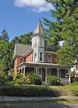 Academy Hill Historic District |
January 4, 1990 (#89002258) |
Roughly bounded by Sarah, 8th, Fulmer and 5th Streets 40°59′19″N 75°11′42″W |
Stroudsburg | |
| 2 | Christ Hamilton United Lutheran Church and Cemetery | 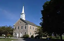 Christ Hamilton United Lutheran Church and Cemetery |
June 11, 1980 (#80003573) |
Bossardsville Road 40°55′33″N 75°17′24″W |
Hamilton Township | |
| 3 | Cold Spring Farm Springhouse | 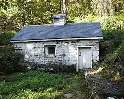 Cold Spring Farm Springhouse |
August 24, 1979 (#79000246) |
Northeast of East Stroudsburg 41°03′44″N 75°01′09″W |
Middle Smithfield Township | |
| 4 | Delaware, Lackawanna and Western Railroad Water Gap Station | 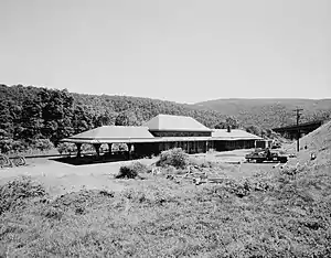 Delaware, Lackawanna and Western Railroad Water Gap Station |
November 27, 2002 (#02001431) |
Waring Drive 40°58′56″N 75°08′12″W |
Delaware Water Gap | |
| 5 | East Stroudsburg Armory | 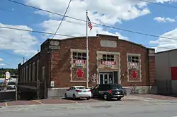 East Stroudsburg Armory |
May 9, 1991 (#91000510) |
271 Washington Street 40°59′35″N 75°11′08″W |
East Stroudsburg | |
| 6 | East Stroudsburg Railroad Station | 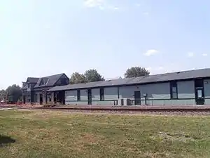 East Stroudsburg Railroad Station |
June 27, 1980 (#80003572) |
Crystal Street 40°59′56″N 75°10′55″W |
East Stroudsburg | Partially destroyed in a 2009 fire. Will either be demolished or moved to Miller Park.[5] |
| 7 | Fenner-Snyder Mill |  Fenner-Snyder Mill |
May 13, 1976 (#76001650) |
U.S. Route 209, north of Sciota 40°56′08″N 75°18′50″W |
Hamilton Township | |
| 8 | Kitson Woolen Mill | 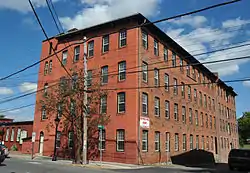 Kitson Woolen Mill |
January 12, 1984 (#84003501) |
411 Main Street 40°59′13″N 75°11′23″W |
Stroudsburg | |
| 9 | John Michael Farm | 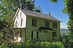 John Michael Farm |
July 8, 1980 (#80000355) |
East of Stroudsburg 41°02′06″N 75°03′25″W |
Middle Smithfield Township | |
| 10 | Monroe County Courthouse | 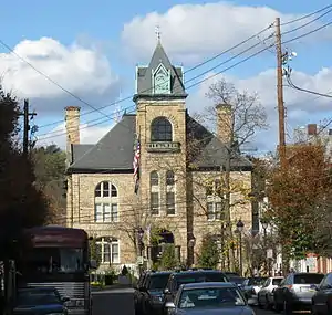 Monroe County Courthouse |
April 18, 1979 (#09000097) |
Seventh and Monroe Sts. 40°59′12″N 75°11′40″W |
Stroudsburg | |
| 11 | Parkside Chapel |  Parkside Chapel |
October 7, 2020 (#100005656) |
5335 Paradise Valley Rd. 41°05′57″N 75°14′55″W |
Henryville | |
| 12 | Pocono Manor Historic District | 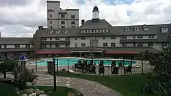 Pocono Manor Historic District |
April 11, 1997 (#97000287) |
Roughly bounded by Pennsylvania Route 314, Lake and Cliff Roads, and Summit Avenue, south of Mount Pocono 41°05′51″N 75°22′28″W |
Pocono and Tobyhanna Townships | |
| 13 | Quiet Valley Farm | 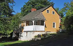 Quiet Valley Farm |
April 23, 1973 (#73001642) |
Southwest of Stroudsburg off U.S. Route 209 40°57′25″N 75°15′03″W |
Hamilton Township | |
| 14 | Ross Common Manor | 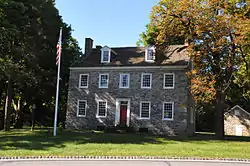 Ross Common Manor |
November 22, 1978 (#78002432) |
South of Saylorsburg on Pennsylvania Route 115 40°51′54″N 75°18′23″W |
Ross Township | |
| 15 | Schoonover Mountain House | 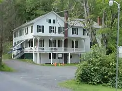 Schoonover Mountain House |
August 21, 1979 (#79000245) |
South of Bushkill 41°04′44″N 75°00′48″W |
Middle Smithfield Township | |
| 16 | Shawnee-Minisink Site |  Shawnee-Minisink Site |
November 9, 2007 (#07001161) |
Confluence of Brodhead Creek and the Delaware River[6] 40°59′25″N 75°08′03″W |
Smithfield Township | |
| 17 | Capt. Jacob Shoemaker House | 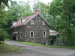 Capt. Jacob Shoemaker House |
July 17, 1979 (#79000247) |
Off Legislative Route 45012 south of Bushkill 41°04′51″N 75°01′55″W |
Middle Smithfield Township | |
| 18 | Stroud Mansion | 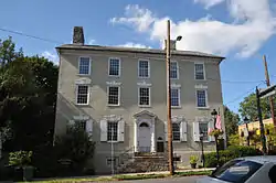 Stroud Mansion |
August 1, 1979 (#79002297) |
Main and 9th Streets 40°59′04″N 75°11′55″W |
Stroudsburg | |
| 19 | John Turn Farm | 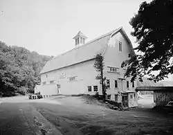 John Turn Farm |
July 23, 1979 (#79000249) |
Northeast of Stroudsburg 41°03′30″N 75°01′25″W |
Middle Smithfield Township | |
| 20 | Zion Lutheran Church | 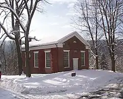 Zion Lutheran Church |
November 9, 1972 (#72000094) |
Off River Road east of East Stroudsburg 41°02′26″N 75°02′19″W |
Middle Smithfield Township |
Former listings
| [3] | Name on the Register | Image | Date listed | Date removed | Location | City or town | Summary |
|---|---|---|---|---|---|---|---|
| 1 | Henryville House | January 6, 1987 (#86003572) | December 14, 2006 | Junction of Pennsylvania Routes 191 and 715 |
Henryville | ||
| 2 | Swiftwater Inn | June 4, 1976 (#76001651) | January 7, 2010 | Pennsylvania Route 611 in Swiftwater 41°05′39″N 75°19′40″W |
Pocono Township | Demolished 2007 as structurally unsound.[7] | |
| 3 | Worthington Hall | 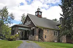 Worthington Hall |
April 14, 1978 (#78002433) | December 18, 1986 | Worthington Avenue at Shawnee-on-the-Delaware 41°00′46″N 75°06′32″W |
Smithfield Township | The rebuilt hall shown here is a copy of the original |
See also
| Wikimedia Commons has media related to National Register of Historic Places in Monroe County, Pennsylvania. |
References
- The latitude and longitude information provided in this table was derived originally from the National Register Information System, which has been found to be fairly accurate for about 99% of listings. Some locations in this table may have been corrected to current GPS standards.
- "National Register of Historic Places: Weekly List Actions". National Park Service, United States Department of the Interior. Retrieved on January 29, 2021.
- Numbers represent an alphabetical ordering by significant words. Various colorings, defined here, differentiate National Historic Landmarks and historic districts from other NRHP buildings, structures, sites or objects.
- The eight-digit number below each date is the number assigned to each location in the National Register Information System database, which can be viewed by clicking the number.
- http://www.poconorecord.com/apps/pbcs.dll/article?AID=/20100819/NEWS/8190326/-1/NEWS01
- Location derived from this Archived 2006-09-13 at the Wayback Machine American University webpage; the NRIS lists the site as "Address Restricted"
- "Swiftwater Inn, demolished in 2007, was on National Register". Pocono Record. Ottaway Community Newspapers. January 27, 2009. Retrieved January 15, 2010.
| Topics |  | |
|---|---|---|
| Lists by county |
| |
| Lists by city | ||
| Other lists | ||
| ||
Municipalities and communities of Monroe County, Pennsylvania, United States | ||
|---|---|---|
| Boroughs | | |
| Townships | ||
| CDPs | ||
| Unincorporated communities |
| |
| Footnotes | ‡This populated place also has portions in an adjacent county | |
| ||
This article is issued from Wikipedia. The text is licensed under Creative Commons - Attribution - Sharealike. Additional terms may apply for the media files.