National Register of Historic Places listings in Snyder County, Pennsylvania
This is a list of the National Register of Historic Places listings in Snyder County, Pennsylvania.
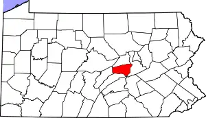
Location of Snyder County in Pennsylvania
This is intended to be a complete list of the properties and districts on the National Register of Historic Places in Snyder County, Pennsylvania, United States. The locations of National Register properties and districts for which the latitude and longitude coordinates are included below, may be seen in a map.[1]
There are 8 properties and districts listed on the National Register in the county. Two sites are further designated as National Historic Landmarks and another is designated as a National Historic Site.
- This National Park Service list is complete through NPS recent listings posted January 29, 2021.[2]
Current listings
| [3] | Name on the Register | Image | Date listed[4] | Location | City or town | Description |
|---|---|---|---|---|---|---|
| 1 | Aline Covered Bridge | 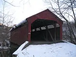 Aline Covered Bridge |
August 10, 1979 (#79002344) |
Northwest of Meiserville 40°40′35″N 76°58′46″W |
Perry Township | |
| 2 | Bridge between Monroe and Penn Townships | 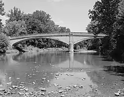 Bridge between Monroe and Penn Townships |
June 22, 1988 (#88000811) |
Legislative Route 54013 over Penns Creek 40°49′32″N 76°52′17″W |
Monroe and Penn Townships | Demolished and replaced with new bridge |
| 3 | Dreese's Covered Bridge | 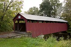 Dreese's Covered Bridge |
August 10, 1979 (#79002343) |
Spans Middle Creek 40°46′31″N 77°08′42″W |
Beaver Township | |
| 4 | East Oriental Covered Bridge | 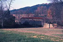 East Oriental Covered Bridge |
August 10, 1979 (#79002246) |
Northeast of Oriental 40°38′20″N 77°00′05″W |
Perry Township | Extends into Susquehanna Township in Juniata County |
| 5 | Gross Bridge | 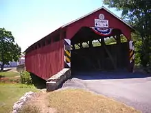 Gross Bridge |
August 29, 1977 (#77001194) |
Township Route 427 in Beaver Springs 40°45′06″N 77°13′24″W |
Spring Township | |
| 6 | North Oriental Covered Bridge | 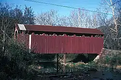 North Oriental Covered Bridge |
August 10, 1979 (#79002247) |
Northeast of Oriental 40°39′42″N 77°00′41″W |
Perry Township | Extends into Susquehanna Township in Juniata County |
| 7 | Selinsgrove Hall and Seibert Hall | 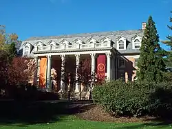 Selinsgrove Hall and Seibert Hall |
October 25, 1979 (#79002345) |
Pine Street 40°47′56″N 76°52′19″W |
Selinsgrove | |
| 8 | Gov. Simon Snyder Mansion |  Gov. Simon Snyder Mansion |
August 25, 1978 (#78002470) |
119–121 North Market Street 40°48′02″N 76°51′43″W |
Selinsgrove |
See also
| Wikimedia Commons has media related to National Register of Historic Places in Snyder County, Pennsylvania. |
References
- The latitude and longitude information provided in this table was derived originally from the National Register Information System, which has been found to be fairly accurate for about 99% of listings. Some locations in this table may have been corrected to current GPS standards.
- "National Register of Historic Places: Weekly List Actions". National Park Service, United States Department of the Interior. Retrieved on January 29, 2021.
- Numbers represent an alphabetical ordering by significant words. Various colorings, defined here, differentiate National Historic Landmarks and historic districts from other NRHP buildings, structures, sites or objects.
- The eight-digit number below each date is the number assigned to each location in the National Register Information System database, which can be viewed by clicking the number.
| Topics |  | |
|---|---|---|
| Lists by county |
| |
| Lists by city | ||
| Other lists | ||
| ||
Municipalities and communities of Snyder County, Pennsylvania, United States | ||
|---|---|---|
| Boroughs | | |
| Townships | ||
| Census-designated places | ||
| Unincorporated communities | ||
| Footnotes | ‡This populated place also has portions in an adjacent county or counties | |
| ||
This article is issued from Wikipedia. The text is licensed under Creative Commons - Attribution - Sharealike. Additional terms may apply for the media files.