National Register of Historic Places listings in Indiana County, Pennsylvania
This is a list of the National Register of Historic Places listings in Indiana County, Pennsylvania.
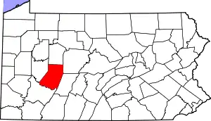
Location of Indiana County in Pennsylvania
This is intended to be a complete list of the properties and districts on the National Register of Historic Places in Indiana County, Pennsylvania, United States. The locations of National Register properties and districts for which the latitude and longitude coordinates are included below, may be seen in a map.[1]
There are 24 properties and districts listed on the National Register in the county.
- This National Park Service list is complete through NPS recent listings posted January 29, 2021.[2]
Current listings
| [3] | Name on the Register | Image | Date listed[4] | Location | Municipality | Description |
|---|---|---|---|---|---|---|
| 1 | Blairsville Armory | 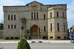 Blairsville Armory |
December 22, 1989 (#89002069) |
119 North Walnut Street 40°25′56″N 79°15′54″W |
Blairsville | |
| 2 | Breezedale | 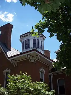 Breezedale |
March 29, 1979 (#79002238) |
Indiana University of Pennsylvania campus 40°37′11″N 79°09′23″W |
Indiana | |
| 3 | Bridge in West Wheatfield Township | 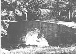 Bridge in West Wheatfield Township |
June 22, 1988 (#88000774) |
Legislative Route 32008 over Richards Run, northeast of Robinson 40°24′11″N 79°07′45″W |
West Wheatfield Township | |
| 4 | Buffalo, Rochester & Pittsburgh Railway Indiana Passenger Station |  Buffalo, Rochester & Pittsburgh Railway Indiana Passenger Station |
May 10, 1993 (#93000365) |
1125 Philadelphia Street 40°37′24″N 79°09′42″W |
Indiana | |
| 5 | Silas M. Clark House |  Silas M. Clark House |
June 15, 1978 (#78002406) |
6th Street and Wayne Avenue 40°37′12″N 79°09′05″W |
Indiana | |
| 6 | Sen. Joseph O. Clark House | 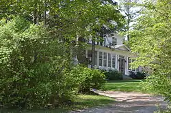 Sen. Joseph O. Clark House |
September 8, 2011 (#11000646) |
247 1st Avenue 40°49′01″N 78°49′35″W |
Glen Campbell | |
| 7 | Commodore Historic District | 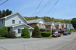 Commodore Historic District |
August 26, 1994 (#94001057) |
Roughly bounded by Pennsylvania Route 286, Vanderbilt Avenue, Musser Street, and Fisher Avenue in Commodore 40°42′49″N 78°56′39″W |
Green Township | |
| 8 | George Diehl Homestead |  George Diehl Homestead |
April 30, 1987 (#87000672) |
East of U.S. Route 422 on Diehl Road, east of Indiana 40°36′29″N 78°58′43″W |
Cherryhill Township | |
| 9 | Downtown Indiana Historic District |  Downtown Indiana Historic District |
April 29, 1993 (#93000366) |
Roughly bounded by Water, 7th, and 6th Streets and Wayne Avenue 40°37′20″N 79°09′06″W |
Indiana | |
| 10 | Eliza Furnace | 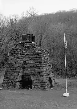 Eliza Furnace |
September 6, 1991 (#91001138) |
Lower Main Street, west of Vintondale 40°29′03″N 78°55′20″W |
Buffington Township | Extends into Cambria County |
| 11 | Graff's Market | 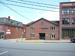 Graff's Market |
December 4, 1980 (#80003504) |
27 North 6th Street 40°37′25″N 79°09′02″W |
Indiana | |
| 12 | Harmon's Covered Bridge | 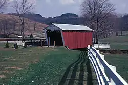 Harmon's Covered Bridge |
August 3, 1979 (#79002242) |
T-488 Over S. Branch Plum Creek; 1/8 mile South of L.R. 32072, Northeast of Willet 40°44′02″N 79°10′31″W |
Washington Township | |
| 13 | Indiana Armory | 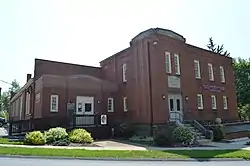 Indiana Armory |
November 14, 1991 (#91001698) |
621 Wayne Avenue 40°37′11″N 79°09′05″W |
Indiana | |
| 14 | Indiana Borough 1912 Municipal Building |  Indiana Borough 1912 Municipal Building |
September 7, 1983 (#83002247) |
39 7th Street 40°37′14″N 79°09′11″W |
Indiana | |
| 15 | Kintersburg Covered Bridge |  Kintersburg Covered Bridge |
August 3, 1979 (#79002241) |
South of Kintersburg 40°42′48″N 79°04′53″W |
Rayne Township | |
| 16 | John B. McCormick House | 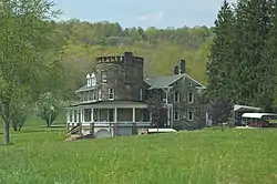 John B. McCormick House |
May 3, 1974 (#74001787) |
West of Georgeville off Pennsylvania Route 210 40°50′19″N 79°07′00″W |
South Mahoning Township | |
| 17 | James Mitchell House |  James Mitchell House |
December 4, 1978 (#78002407) |
57 South 6th Street 40°37′18″N 79°09′02″W |
Indiana | |
| 18 | Old Indiana County Courthouse |  Old Indiana County Courthouse |
October 29, 1974 (#74001788) |
601 Philadelphia Street 40°37′23″N 79°09′07″W |
Indiana | |
| 19 | Old Indiana County Jail and Sheriff's Office |  Old Indiana County Jail and Sheriff's Office |
September 27, 1979 (#79002240) |
6th Street and Nixon Avenue 40°37′23″N 79°09′08″W |
Indiana | |
| 20 | St. Peter's Episcopal Church and Rectory | 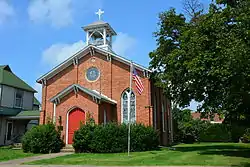 St. Peter's Episcopal Church and Rectory |
May 9, 1988 (#88000463) |
36-38 West Campbell Street 40°25′55″N 79°15′56″W |
Blairsville | |
| 21 | Saltsburg Historic District |  Saltsburg Historic District |
May 7, 1992 (#92000386) |
Roughly west of Plum and Walnut Alleys to the Kiskiminetas River 40°29′02″N 79°27′04″W |
Saltsburg | |
| 22 | John Sutton Hall | 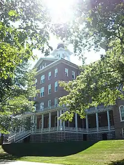 John Sutton Hall |
September 17, 1975 (#75001643) |
Indiana University of Pennsylvania campus 40°37′03″N 79°09′32″W |
Indiana | |
| 23 | Thomas Covered Bridge | 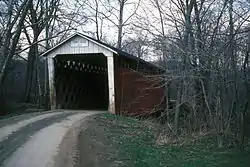 Thomas Covered Bridge |
August 3, 1979 (#79002237) |
T-414 over Crooked Creek, ½ mile south of its junction with L.R. 32061, north of Fulton Run, and southwest of Creekside 40°39′50″N 79°14′13″W |
Armstrong Township | |
| 24 | Trusal Covered Bridge | 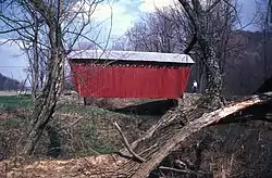 Trusal Covered Bridge |
August 3, 1979 (#79002243) |
T-406 Over Plum Creek, 1.75 miles (2.82 km) east of Five Points, and west of Willet 40°43′49″N 79°11′05″W |
Washington Township |
See also
| Wikimedia Commons has media related to National Register of Historic Places in Indiana County, Pennsylvania. |
References
- The latitude and longitude information provided in this table was derived originally from the National Register Information System, which has been found to be fairly accurate for about 99% of listings. Some locations in this table may have been corrected to current GPS standards.
- "National Register of Historic Places: Weekly List Actions". National Park Service, United States Department of the Interior. Retrieved on January 29, 2021.
- Numbers represent an alphabetical ordering by significant words. Various colorings, defined here, differentiate National Historic Landmarks and historic districts from other NRHP buildings, structures, sites or objects.
- The eight-digit number below each date is the number assigned to each location in the National Register Information System database, which can be viewed by clicking the number.
| Topics |  | |
|---|---|---|
| Lists by county |
| |
| Lists by city | ||
| Other lists | ||
| ||
Municipalities and communities of Indiana County, Pennsylvania, United States | ||
|---|---|---|
| Boroughs | | |
| Townships | ||
| CDPs | ||
| Unincorporated communities | ||
| ||
This article is issued from Wikipedia. The text is licensed under Creative Commons - Attribution - Sharealike. Additional terms may apply for the media files.