National Register of Historic Places listings in Lycoming County, Pennsylvania
This is a list of the National Register of Historic Places listings in Lycoming County, Pennsylvania.
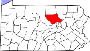
Location of Lycoming County in Pennsylvania
This is intended to be a complete list of the properties and districts on the National Register of Historic Places in Lycoming County, Pennsylvania, United States. The locations of National Register properties and districts for which the latitude and longitude coordinates are included below, may be seen in a map.[1]
There are 21 properties and districts listed on the National Register in the county.
- This National Park Service list is complete through NPS recent listings posted January 29, 2021.[2]
Current listings
| [3] | Name on the Register | Image | Date listed[4] | Location | City or town | Description |
|---|---|---|---|---|---|---|
| 1 | Archeological Site 36 LY 37 |  Archeological Site 36 LY 37 |
April 14, 1982 (#82003799) |
Coextensive with Canfield Island[5] 41°14′32″N 76°57′11″W |
Loyalsock Township | |
| 2 | Bridge in Brown Township | 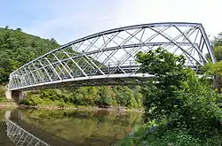 Bridge in Brown Township |
June 22, 1988 (#88000844) |
Legislative Route 41022 over Pine Creek 41°29′43″N 77°29′51″W |
Brown Township | |
| 3 | Bridge in Lewis Township |  Bridge in Lewis Township |
June 22, 1988 (#88000845) |
Legislative Route 41051 over Lycoming Creek 41°26′54″N 76°58′52″W |
Lewis Township | Torn Down (Replaced) |
| 4 | Bridge in Porter Township |  Bridge in Porter Township |
June 22, 1988 (#88000842) |
Legislative Route 41017 over Pine Creek 41°10′51″N 77°16′43″W |
Porter Township | |
| 5 | Buttonwood Covered Bridge | 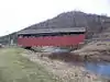 Buttonwood Covered Bridge |
July 24, 1980 (#80003569) |
Southwest of Liberty on Township 816 41°30′35″N 77°07′50″W |
Jackson Township | |
| 6 | Cogan House Covered Bridge | 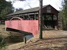 Cogan House Covered Bridge |
July 24, 1980 (#80003567) |
Southeast of White Pine on Township 784 41°23′53″N 77°12′04″W |
Cogan House Township | |
| 7 | English Center Suspension Bridge | 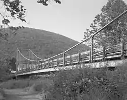 English Center Suspension Bridge |
December 14, 1978 (#78002428) |
Over Pine Creek at English Center 41°26′05″N 77°17′21″W |
Pine Township | |
| 8 | Hart Building | 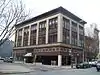 Hart Building |
September 7, 1984 (#84003490) |
26–30 West 3rd Street 41°14′27″N 77°00′08″W |
Williamsport | |
| 9 | Peter Herdic House | 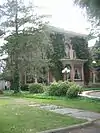 Peter Herdic House |
November 21, 1978 (#78002429) |
407 4th Street 41°14′23″N 77°00′33″W |
Williamsport | |
| 10 | Houseknecht Farm | 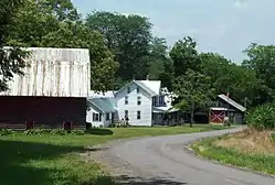 Houseknecht Farm |
August 7, 2007 (#07000795) |
812 J. Houseknecht Road 41°10′41″N 76°38′53″W |
Moreland Township | |
| 11 | Jersey Shore Historic District | 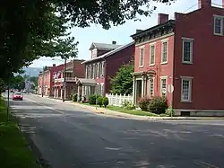 Jersey Shore Historic District |
March 31, 1975 (#75001653) |
Irregular shape roughly bounded by Lawshe Run, West Branch Susquehanna River, southern borough boundaries, and Tomb Avenue 41°12′04″N 77°15′18″W |
Jersey Shore | |
| 12 | Lairdsville Covered Bridge | 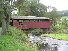 Lairdsville Covered Bridge |
July 24, 1980 (#80003568) |
West of Lairdsville on Township 664 41°12′26″N 76°38′10″W |
Moreland Township | |
| 13 | Lycoming Rubber Company |  Lycoming Rubber Company |
December 21, 2017 (#100001909) |
1307 Park Ave. 41°14′35″N 77°02′00″W |
Williamsport | |
| 14 | Millionaire's Row Historic District |  Millionaire's Row Historic District |
January 24, 1985 (#85000120) |
Roughly bounded by Nichols Place, Elmira and West 3rd Streets, and 7th Avenue 41°14′20″N 77°00′59″W |
Williamsport | |
| 15 | Muncy Historic District | 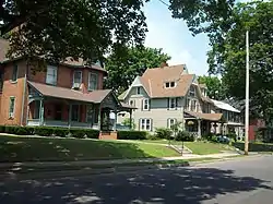 Muncy Historic District |
July 3, 1980 (#80003570) |
Roughly bounded by Ridell Lane, Sherman, Washington and Mechanic Streets 41°12′13″N 76°47′07″W |
Muncy | |
| 16 | Original Little League Field |  Original Little League Field |
December 3, 2014 (#14000996) |
1695 W. 4th St. 41°14′27″N 77°02′41″W |
Williamsport | |
| 17 | Reading-Halls Station Bridge | 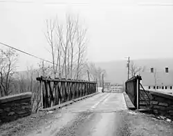 Reading-Halls Station Bridge |
January 17, 1980 (#80003571) |
Northwest of Muncy off U.S. Route 220 41°14′09″N 76°49′58″W |
Muncy Township | |
| 18 | St. James Episcopal Church | 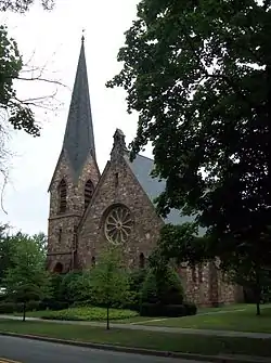 St. James Episcopal Church |
November 20, 1979 (#79002294) |
215 South Main Street 41°12′05″N 76°47′09″W |
Muncy | |
| 19 | U.S. Post Office | 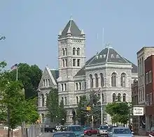 U.S. Post Office |
March 16, 1972 (#72001135) |
245 W. 4th St. 41°14′24″N 77°00′23″W |
Williamsport | |
| 20 | Williamsport Armory |  Williamsport Armory |
November 14, 1991 (#91001704) |
1300 Penn Street 41°15′15″N 76°59′34″W |
Williamsport | |
| 21 | Williamsport City Hall | 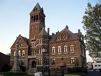 Williamsport City Hall |
November 7, 1976 (#76001648) |
454 Pine St. 41°14′33″N 77°00′15″W |
Williamsport |
Former listing
| [3] | Name on the Register | Image | Date listed | Date removed | Location | City or town | Summary |
|---|---|---|---|---|---|---|---|
| 1 | Lycoming County Courthouse | .jpg.webp) Lycoming County Courthouse |
Unknown (#74002331) | 1974 | Pine and W. 3rd Sts. |
Williamsport | Demolished in 1969. |
| 2 | Bridge in Plunketts Creek Township | 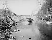 Bridge in Plunketts Creek Township |
Unspecified (#88000830) | July 22, 2002 | Legislative Route 41053 over Plunketts Creek 41°24′32″N 76°48′10″W |
Plunketts Creek Township | Damaged in a flood on January 21, 1996 and eventually demolished. |
See also
| Wikimedia Commons has media related to National Register of Historic Places in Lycoming County, Pennsylvania. |
References
- The latitude and longitude information provided in this table was derived originally from the National Register Information System, which has been found to be fairly accurate for about 99% of listings. Some locations in this table may have been corrected to current GPS standards.
- "National Register of Historic Places: Weekly List Actions". National Park Service, United States Department of the Interior. Retrieved on January 29, 2021.
- Numbers represent an alphabetical ordering by significant words. Various colorings, defined here, differentiate National Historic Landmarks and historic districts from other NRHP buildings, structures, sites or objects.
- The eight-digit number below each date is the number assigned to each location in the National Register Information System database, which can be viewed by clicking the number.
- Location derived from its NRHP nomination form; the NRIS lists the site as "Address Restricted"
| Topics |  | |
|---|---|---|
| Lists by county |
| |
| Lists by city | ||
| Other lists | ||
| ||
Municipalities and communities of Lycoming County, Pennsylvania, United States | ||
|---|---|---|
| City | | |
| Boroughs | ||
| Townships |
| |
| CDPs | ||
| Unincorporated communities | ||
| Ghost town | ||
| Footnotes | ‡This populated place also has portions in an adjacent county | |
| ||
This article is issued from Wikipedia. The text is licensed under Creative Commons - Attribution - Sharealike. Additional terms may apply for the media files.