National Register of Historic Places listings in Cumberland County, Pennsylvania
This is a list of the National Register of Historic Places listings in Cumberland County, Pennsylvania.
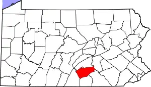
Location of Cumberland County in Pennsylvania
This is intended to be a complete list of the properties and districts on the National Register of Historic Places in Cumberland County, Pennsylvania. The locations of National Register properties and districts for which the latitude and longitude coordinates are included below may be seen in a map.[1]
There are 33 properties and districts listed on the National Register in the county. Two sites are further designated as National Historic Landmarks.
- This National Park Service list is complete through NPS recent listings posted January 29, 2021.[2]
Current listings
| [3] | Name on the Register | Image | Date listed[4] | Location | City or town | Description |
|---|---|---|---|---|---|---|
| 1 | William Black Homestead |  William Black Homestead |
July 20, 1977 (#77001159) |
Drexel Hill Park Road 40°13′20″N 76°53′03″W |
New Cumberland | |
| 2 | Benjamin Blythe Homestead |  Benjamin Blythe Homestead |
September 15, 1977 (#77001160) |
217 Means Hollow Road 40°02′03″N 77°30′43″W |
Shippensburg | |
| 3 | Boiling Springs Historic District | 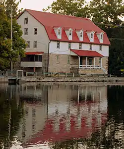 Boiling Springs Historic District |
December 3, 1984 (#84000566) |
Roughly bounded by High and First Streets, Boiling Springs Lake, and Yellow Breeches Creek 40°08′54″N 77°07′40″W |
Boiling Springs | |
| 4 | Carlisle Armory | 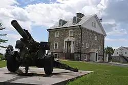 Carlisle Armory |
December 22, 1989 (#89002071) |
504 Cavalry Road 40°13′13″N 77°10′43″W |
Carlisle | |
| 5 | Carlisle Historic District | 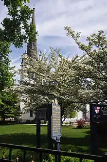 Carlisle Historic District |
June 15, 1979 (#79002214) |
Roughly bounded by Penn, East, Walnut and College Streets 40°12′08″N 77°11′04″W |
Carlisle | |
| 6 | Carlisle Indian School | 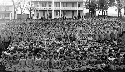 Carlisle Indian School |
October 15, 1966 (#66000658) |
East edge of Carlisle on U.S. Route 11 40°12′32″N 77°10′41″W |
Carlisle | |
| 7 | Cumberland Valley Railroad Station and Station Master's House |  Cumberland Valley Railroad Station and Station Master's House |
November 17, 1978 (#78002384) |
2 West Strawberry Alley and 4 West Strawberry Alley 40°12′49″N 77°00′32″W |
Mechanicsburg | |
| 8 | Cumberland Valley State Normal School Historic District | 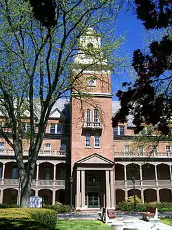 Cumberland Valley State Normal School Historic District |
January 11, 1985 (#85000076) |
Roughly bounded by North Prince Street, Stewart, Old Main, Gilbert and Henderson Drives 40°03′30″N 77°31′22″W |
Shippensburg | |
| 9 | Dykeman's Spring | 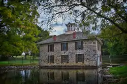 Dykeman's Spring |
May 27, 1999 (#99000645) |
Dykeman Road, 0.25 miles (0.40 km) east of PA 696 40°02′33″N 77°30′57″W |
Shippensburg | |
| 10 | Johannes Eberly House | 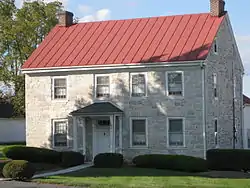 Johannes Eberly House |
April 2, 1973 (#73001619) |
Northeast of Mechanicsburg on U.S. Route 11 40°14′25″N 76°58′41″W |
Hampden Township | |
| 11 | Etters Bridge |  Etters Bridge |
February 27, 1986 (#86000308) |
Green Lane Drive and Yellow Breeches Creek 40°13′28″N 76°53′53″W |
Lower Allen Township | Extends into York County |
| 12 | Gilbert Bridge | 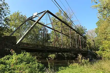 Gilbert Bridge |
May 5, 1989 (#89000355) |
Bishop Road / Gilbert Road over Yellow Breeches Creek 40°09′13″N 76°58′57″W |
Grantham | Extends into York County |
| 13 | James Given Tavern |  James Given Tavern |
July 24, 1992 (#92000943) |
1189 Walnut Bottom Road 40°10′51″N 77°13′11″W |
South Middleton Township | |
| 14 | Amelia S. Givin Free Library |  Amelia S. Givin Free Library |
August 11, 2004 (#04000841) |
114 North Baltimore Avenue 40°06′59″N 77°11′21″W |
Mount Holly Springs | |
| 15 | Hessian Powder Magazine | 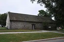 Hessian Powder Magazine |
May 17, 1974 (#74001778) |
Guardhouse and Garrison Lanes 40°11′52″N 77°10′42″W |
Carlisle | |
| 16 | Irving Female College | 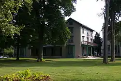 Irving Female College |
May 6, 1983 (#83002231) |
Filbert, Main, and Simpson Streets 40°12′51″N 76°59′59″W |
Mechanicsburg | |
| 17 | Market Street Bridge | _HAER_color_1.jpg.webp) Market Street Bridge |
June 22, 1988 (#88000759) |
Market Street/LR 34 over Susquehanna River 40°15′27″N 76°53′00″W |
Wormleysburg | Extends into Dauphin County |
| 18 | Mechanicsburg Commercial Historic District |  Mechanicsburg Commercial Historic District |
April 21, 1983 (#83002232) |
Main Street from Arch to High Street 40°12′46″N 77°00′33″W |
Mechanicsburg | |
| 19 | Melester Barn | February 3, 2020 (#100004931) |
1110 South Spring Garden St. 40°10′27″N 77°10′40″W |
South Middleton Township | ||
| 20 | Newville Historic District | 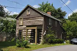 Newville Historic District |
June 28, 2010 (#10000397) |
Roughly bounded by Cove Alley, Big Spring Creek, the Cumberland Valley Railroad right-of-way, Washington St. 40°10′23″N 77°23′55″W |
Newville | |
| 21 | Old West, Dickinson College | 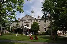 Old West, Dickinson College |
October 15, 1966 (#66000659) |
Dickinson College campus 40°12′09″N 77°11′45″W |
Carlisle | |
| 22 | Adam Orris House |  Adam Orris House |
December 30, 1987 (#87002206) |
318 West Main Street 40°12′42″N 77°00′51″W |
Mechanicsburg | |
| 23 | Peace Church | 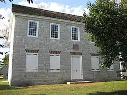 Peace Church |
March 24, 1972 (#72001114) |
Northwestern corner of Trindle and St. John's Roads 40°13′54″N 76°57′25″W |
Camp Hill | |
| 24 | Pine Grove Iron Works | 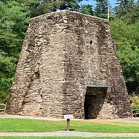 Pine Grove Iron Works |
April 13, 1977 (#77001158) |
South of Dickinson on Pennsylvania Route 233 40°01′47″N 77°18′15″W |
Dickinson Township | Also known as Pine Grove Furnace. Site includes the ironmaster's mansion and the former grist mill, now used as the Appalachian Trail Museum. |
| 25 | Ramp Covered Bridge |  Ramp Covered Bridge |
August 25, 1980 (#80003480) |
East of Newburg on Township 374 40°08′10″N 77°31′26″W |
Hopewell Township | |
| 26 | Shippen House | 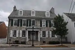 Shippen House |
November 25, 1975 (#75001636) |
52 West King Street 40°02′59″N 77°31′18″W |
Shippensburg | |
| 27 | Shippensburg Historic District | 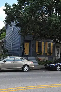 Shippensburg Historic District |
June 7, 1984 (#84003346) |
Roughly bounded by Lutz Avenue, Kenneth, Spring, and Fort Streets 40°03′08″N 77°31′11″W |
Shippensburg | |
| 28 | Simpson Street School | 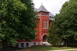 Simpson Street School |
February 24, 1983 (#83002233) |
Simpson and High Streets 40°12′39″N 77°00′39″W |
Mechanicsburg | |
| 29 | George Trimble House | 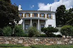 George Trimble House |
July 24, 1992 (#92000945) |
50 Pleasant Grove Road 40°16′11″N 77°02′55″W |
Silver Spring Township | |
| 30 | Union Hotel | 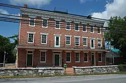 Union Hotel |
May 5, 1989 (#89000362) |
240 Old Gettysburg Road 40°10′41″N 76°59′30″W |
Shepherdstown | |
| 31 | Widow Piper's Tavern |  Widow Piper's Tavern |
January 17, 1974 (#74001779) |
Southwestern corner of King and Queen Streets 40°03′16″N 77°30′48″W |
Shippensburg | |
| 32 | John Williams House | 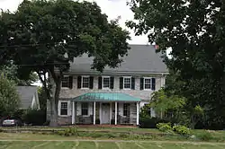 John Williams House |
July 28, 1977 (#77001161) |
1554 Williams Grove Rd., 0.5 miles (0.80 km) south of Williams Grove 40°08′52″N 77°01′49″W |
Williams Grove | |
| 33 | John Wormley House |  John Wormley House |
November 21, 1976 (#76001630) |
126 North Front Street 40°15′23″N 76°54′03″W |
Wormleysburg |
Former listings
| [3] | Name on the Register | Image | Date listed | Date removed | Location | City or town | Summary |
|---|---|---|---|---|---|---|---|
| 1 | John McCullough House | December 20, 1978 (#78002385) | June 25, 2013 | Southeast of Newville on Pennsylvania Route 233 40°09′29″N 77°23′03″W |
West Pennsboro Township | Demolished | |
| 2 | Sterrett-Hassinger House |  Sterrett-Hassinger House |
September 15, 1983 (#83002234) | January 20, 2000 | Three Squares Hollow Road |
Upper Mifflin Township |
See also
| Wikimedia Commons has media related to National Register of Historic Places in Cumberland County, Pennsylvania. |
References
- The latitude and longitude information provided in this table was derived originally from the National Register Information System, which has been found to be fairly accurate for about 99% of listings. Some locations in this table may have been corrected to current GPS standards.
- "National Register of Historic Places: Weekly List Actions". National Park Service, United States Department of the Interior. Retrieved on January 29, 2021.
- Numbers represent an alphabetical ordering by significant words. Various colorings, defined here, differentiate National Historic Landmarks and historic districts from other NRHP buildings, structures, sites or objects.
- The eight-digit number below each date is the number assigned to each location in the National Register Information System database, which can be viewed by clicking the number.
| Topics | 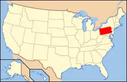 | |
|---|---|---|
| Lists by county |
| |
| Lists by city | ||
| Other lists | ||
| ||
Municipalities and communities of Cumberland County, Pennsylvania, United States | ||
|---|---|---|
| Boroughs | | |
| Townships | ||
| CDPs | ||
| Unincorporated communities | ||
| Footnotes | ‡This populated place also has portions in an adjacent county or counties | |
| ||
This article is issued from Wikipedia. The text is licensed under Creative Commons - Attribution - Sharealike. Additional terms may apply for the media files.