Mount Crested Butte, Colorado
Mt. Crested Butte is a home rule municipality in Gunnison County, Colorado, United States. Mount Crested Butte is the home of the Crested Butte Mountain Resort. The population was 801 at the 2010 census.[8] ZIP code 81225 serves post office boxes for Mount Crested Butte and for neighboring Crested Butte; mail must be addressed to Crested Butte.[7]
Mt. Crested Butte, Colorado | |
|---|---|
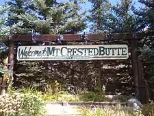 Welcome to Mt. Crested Butte, elevation 9,375 feet (2,858 m) | |
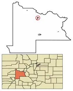 Location of Mount Crested Butte in Gunnison County, Colorado. | |
| Coordinates: 38°54′6″N 106°58′3″W | |
| Country | |
| State | |
| County[1] | Gunnison |
| Incorporated (town) | 1973[2] |
| Government | |
| • Type | Home Rule Municipality[1] |
| Area | |
| • Total | 2.05 sq mi (5.30 km2) |
| • Land | 2.05 sq mi (5.30 km2) |
| • Water | 0.00 sq mi (0.00 km2) |
| Elevation | 9,898 ft (3,017 m) |
| Population | |
| • Total | 801 |
| • Estimate (2019)[6] | 876 |
| • Density | 427.94/sq mi (165.22/km2) |
| Time zone | UTC-7 (MST) |
| • Summer (DST) | UTC-6 (MDT) |
| ZIP code[7] | 81225 (Crested Butte PO Box) |
| Area code(s) | 970 |
| FIPS code | 08-52570 |
| GNIS feature ID | 0197451 |
| Website | www |
Geography
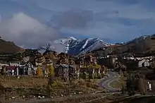
Mt. Crested Butte is located in north-central Gunnison County at 38°54′6″N 106°58′3″W (38.901649, -106.967554)[9] in the Gunnison National Forest, 2 miles (3 km) north of the town of Crested Butte on Gothic Road. The town sits at the northern and western base of Crested Butte, a 12,162-foot (3,707 m) summit that is the site of the Crested Butte ski resort.
According to the United States Census Bureau, the town of Mt. Crested Butte covers a total area of 2.22 square miles (5.75 km2), all of it land.[8]
Demographics
| Historical population | |||
|---|---|---|---|
| Census | Pop. | %± | |
| 1980 | 272 | — | |
| 1990 | 264 | −2.9% | |
| 2000 | 707 | 167.8% | |
| 2010 | 801 | 13.3% | |
| 2019 (est.) | 876 | [6] | 9.4% |
| U.S. Decennial Census[10] | |||
As of the census[5] of 2000, there were 707 people, 323 households, and 114 families residing in the town. The population density was 459.2 people per square mile (177.3/km2). There were 1,052 housing units at an average density of 683.3 per square mile (263.8/km2). The racial makeup of the town was 97.31% White, 1.56% Native American, 0.28% from other races, and 0.85% from two or more races. Hispanic or Latino of any race were 3.54% of the population.
There were 323 households, out of which 11.8% had children under the age of 18 living with them, 31.6% were married couples living together, 2.8% had a female householder with no husband present, and 64.4% were non-families. 26.9% of all households were made up of individuals, and 1.2% had someone living alone who was 65 years of age or older. The average household size was 2.19 and the average family size was 2.55.
In the town, the population was spread out, with 9.3% under the age of 18, 17.3% from 18 to 24, 48.2% from 25 to 44, 21.5% from 45 to 64, and 3.7% who were 65 years of age or older. The median age was 31 years. For every 100 females, there were 160.9 males. For every 100 females age 18 and over, there were 156.4 males.
The median income for a household in the town was $48,864, and the median income for a family was $64,167. Males had a median income of $33,542 versus $32,188 for females. The per capita income for the town was $35,657. About 2.7% of families and 13.0% of the population were below the poverty line, including none of those under the age of eighteen or sixty-five or over.
See also
- Outline of Colorado
- State of Colorado
- Colorado cities and towns
- Colorado municipalities
- Colorado counties
- Colorado cities and towns
- West Elk Mountains
References
- "Active Colorado Municipalities". State of Colorado, Department of Local Affairs. Archived from the original on 2009-12-12. Retrieved 2007-09-01.
- "Colorado Municipal Incorporations". State of Colorado, Department of Personnel & Administration, Colorado State Archives. 2004-12-01. Retrieved 2007-09-02.
- "2019 U.S. Gazetteer Files". United States Census Bureau. Retrieved July 1, 2020.
- "US Board on Geographic Names". United States Geological Survey. 2007-10-25. Retrieved 2008-01-31.
- "U.S. Census website". United States Census Bureau. Retrieved 2008-01-31.
- "Population and Housing Unit Estimates". United States Census Bureau. May 24, 2020. Retrieved May 27, 2020.
- "ZIP Code Lookup". United States Postal Service. Archived from the original (JavaScript/HTML) on November 4, 2010. Retrieved November 22, 2007.
- "Geographic Identifiers: 2010 Demographic Profile Data (G001): Mount Crested Butte town, Colorado". American Factfinder. U.S. Census Bureau. Retrieved November 18, 2016.
- "US Gazetteer files: 2010, 2000, and 1990". United States Census Bureau. 2011-02-12. Retrieved 2011-04-23.
- "Census of Population and Housing". Census.gov. Retrieved June 4, 2015.
External links
- Town of Mt. Crested Butte official website
- CDOT map of the Town of Mt. Crested Butte
- Gunnison-Crested Butte Tourism Association
- Crested Butte Resort
- 3dSkiMap of Crested Butte Mountain Resort
Municipalities and communities of Gunnison County, Colorado, United States | ||
|---|---|---|
| City |  Map of Colorado highlighting Gunnison County | |
| Towns | ||
| CDP | ||
| Unincorporated communities | ||
| Ghost towns | ||
| ||

| Authority control |
|---|