National Register of Historic Places listings in Georgetown County, South Carolina
This is a list of the National Register of Historic Places listings in Georgetown County, South Carolina.
This is intended to be a complete list of the properties and districts on the National Register of Historic Places in Georgetown County, South Carolina, United States. The locations of National Register properties and districts for which the latitude and longitude coordinates are included below, may be seen in a map.[1]
There are 38 properties and districts listed on the National Register in the county, including 3 National Historic Landmarks. One of the National Historic Landmarks, Atalaya and Brookgreen Gardens, is composed of two parts that are listed on the Register separately. Another property was once listed but has been removed.
- This National Park Service list is complete through NPS recent listings posted January 29, 2021.[2]
Current listings
| [3] | Name on the Register[4] | Image | Date listed[5] | Location | City or town | Description |
|---|---|---|---|---|---|---|
| 1 | All Saints' Episcopal Church, Waccamaw | 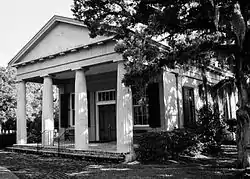 All Saints' Episcopal Church, Waccamaw |
March 13, 1991 (#91000232) |
South Carolina Highway 255 0.2 miles north of its junction with South Carolina Highway 46 33°28′03″N 79°08′24″W |
Pawleys Island | |
| 2 | Annandale Plantation | Annandale Plantation |
October 25, 1973 (#73001709) |
About 14 miles south of Georgetown between South Carolina Highways 18 and 30 33°13′01″N 79°18′10″W |
Georgetown | |
| 3 | Arcadia Plantation | _ELEVATION_-_Arcadia_Plantation%252C_U.S._Highway_17_vicinity%252C_Georgetown%252C_Georgetown_County%252C_SC_HABS_SC%252C22-GEOTO.V%252C5-2.tif.jpg.webp) Arcadia Plantation |
January 3, 1978 (#78002509) |
5 miles (8 km) east of Georgetown off U.S. Route 17 33°23′01″N 79°13′25″W |
Georgetown | |
| 4 | Atalaya | 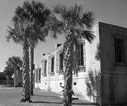 Atalaya |
September 7, 1984 (#84002045) |
Off U.S. Route 17 33°30′50″N 79°05′07″W |
Murrells Inlet | |
| 5 | Battery White | 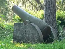 Battery White |
November 16, 1977 (#77001222) |
South of Georgetown on Belle Isle Rd. 33°18′13″N 79°17′46″W |
Georgetown | |
| 6 | Belle Isle Rice Mill Chimney | October 3, 1988 (#88000525) |
Cat Island 33°12′02″N 79°15′30″W |
Georgetown | ||
| 7 | Beneventum Plantation House | .jpg.webp) Beneventum Plantation House |
October 3, 1988 (#88000526) |
Off County Road 431 33°26′43″N 79°15′39″W |
Georgetown | |
| 8 | Black River Plantation House | 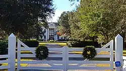 Black River Plantation House |
March 2, 1994 (#94000062) |
Southwestern side of South Carolina Highway 51, 0.5 miles northwest of Peters Creek 33°30′37″N 79°18′01″W |
Georgetown | |
| 9 | Brookgreen Gardens | 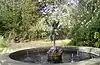 Brookgreen Gardens |
April 15, 1978 (#78002510) |
18 miles (28.8 km) northeast of Georgetown on U.S. Route 17 33°31′14″N 79°05′59″W |
Georgetown | |
| 10 | Cedar Grove Plantation Chapel | 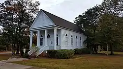 Cedar Grove Plantation Chapel |
March 13, 1991 (#91000231) |
South Carolina Highway 255, 0.2 miles north of its junction with South Carolina Highway 46 33°28′02″N 79°08′19″W |
Pawleys Island | |
| 11 | Chicora Wood Plantation | %252C_Georgetown_vicinity_(Georgetown_County%252C_South_Carolina).jpg.webp) Chicora Wood Plantation |
April 11, 1973 (#73001710) |
12 miles northeast of Georgetown on County Road 52 33°31′03″N 79°10′32″W |
Georgetown | |
| 12 | Fairfield Rice Mill Chimney | October 3, 1988 (#88000527) |
Off U.S. Route 17 33°23′33″N 79°13′11″W |
Georgetown | ||
| 13 | Friendfield Plantation | .jpg.webp) Friendfield Plantation |
April 12, 1996 (#96000409) |
Roughly bounded by U.S. Route 521-17A, the Sampit River, Whites Creek, and Creek Rd. 33°22′39″N 79°20′29″W |
Georgetown | |
| 14 | Georgetown Historic District | .jpg.webp) Georgetown Historic District |
October 14, 1971 (#71000781) |
Along the northern side of the Sampit River 33°21′58″N 79°16′51″W |
Georgetown | |
| 15 | Georgetown Lighthouse | 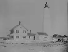 Georgetown Lighthouse |
December 30, 1974 (#74001857) |
On North Island, about 12 miles southeast of Georgetown 33°13′20″N 79°11′07″W |
Georgetown | |
| 16 | Hobcaw Barony | _5a31131r.jpg.webp) Hobcaw Barony |
November 2, 1994 (#94001236) |
Roughly bounded by U.S. Route 17, Winyah and Mud Bays and Jones Creek 33°19′23″N 79°13′06″W |
Georgetown | |
| 17 | Hopsewee | 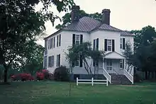 Hopsewee |
January 25, 1971 (#71000782) |
12 miles south of Georgetown on U.S. Route 17 33°12′38″N 79°23′05″W |
Georgetown | |
| 18 | Keithfield Plantation | October 3, 1988 (#88000529) |
Off County Road 52 33°26′21″N 79°14′31″W |
Georgetown | ||
| 19 | Mansfield Plantation |  Mansfield Plantation |
December 6, 1977 (#77001223) |
5 miles north of Georgetown off U.S. Route 701 33°26′05″N 79°15′33″W |
Georgetown | |
| 20 | Milldam Rice Mill and Rice Barn | October 3, 1988 (#88000530) |
Off County Road 30 33°12′09″N 79°19′58″W |
Georgetown | ||
| 21 | Minim Island Shell Midden (38GE46) | August 18, 1982 (#82003852) |
Address Restricted |
Georgetown | ||
| 22 | Murrells Inlet Historic District |  Murrells Inlet Historic District |
November 25, 1980 (#80003670) |
Off U.S. Route 17 33°33′44″N 79°01′14″W |
Murrells Inlet | |
| 23 | Nightingale Hall Rice Mill Chimney | October 3, 1988 (#88000531) |
Off County Road 52 33°26′46″N 79°12′46″W |
Georgetown | ||
| 24 | Old Market Building | .jpg.webp) Old Market Building |
December 3, 1969 (#69000166) |
Front and Screven Sts. 33°21′56″N 79°16′57″W |
Georgetown | |
| 25 | Parrish's Motor Court |  Parrish's Motor Court |
October 16, 2017 (#100001748) |
5098 US 17 Bus. 33°32′08″N 79°03′15″W |
Murrells Inlet | |
| 26 | Pawleys Island Historic District |  Pawleys Island Historic District |
November 15, 1972 (#72001211) |
Western side of Pawleys Island 33°25′26″N 79°07′50″W |
Pawleys Island | |
| 27 | Pee Dee River Rice Planters Historic District | .jpg.webp) Pee Dee River Rice Planters Historic District |
October 3, 1988 (#88000532) |
Along the Pee Dee and Waccamaw Rivers; also 1 Ave. of Live Oaks 33°30′13″N 79°10′11″W |
Georgetown | 1 Ave of Live Oaks was listed as a boundary increase to the district on October 16, 2020 |
| 28 | Pleasant Hill Consolidated School | 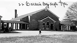 Pleasant Hill Consolidated School |
April 30, 1998 (#98000421) |
11957 Pleasant Hill Dr. 33°40′44″N 79°22′07″W |
Hemingway | |
| 29 | Prince Frederick's Chapel Ruins |  Prince Frederick's Chapel Ruins |
August 28, 1974 (#74001858) |
Southeast of Plantersville on County Road 52 33°30′20″N 79°10′49″W |
Plantersville | |
| 30 | Prince George Winyah Church (Episcopal) and Cemetery | 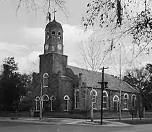 Prince George Winyah Church (Episcopal) and Cemetery |
May 6, 1971 (#71000783) |
Corner of Broad and Highmarket Sts. 33°22′08″N 79°16′49″W |
Georgetown | |
| 31 | Joseph H. Rainey House | 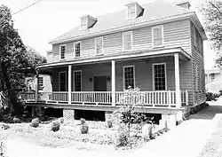 Joseph H. Rainey House |
April 20, 1984 (#84003877) |
909 Prince St. 33°22′08″N 79°17′05″W |
Georgetown | |
| 32 | Richmond Hill Plantation Archeological Sites | October 6, 1988 (#88000537) |
Address Restricted |
Murrells Inlet | ||
| 33 | Rural Hall Plantation House | October 3, 1988 (#88000533) |
Off County Road 179 33°30′46″N 79°20′40″W |
Georgetown | ||
| 34 | Sandy Island School | October 5, 2020 (#100005641) |
32 Sandy Island Rd. Coordinates missing |
Sandy Island | ||
| 35 | Summer Chapel Rectory, Prince Frederick's Episcopal Church | 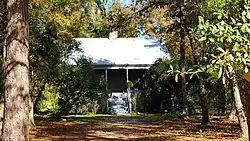 Summer Chapel Rectory, Prince Frederick's Episcopal Church |
October 3, 1988 (#88000536) |
County Road 52 33°33′18″N 79°12′53″W |
Plantersville | |
| 36 | Summer Chapel, Prince Frederick's Episcopal Church |  Summer Chapel, Prince Frederick's Episcopal Church |
October 3, 1988 (#88000535) |
County Road 52 33°33′17″N 79°12′42″W |
Plantersville | |
| 37 | Weehaw Rice Mill Chimney | October 3, 1988 (#88000534) |
Off County Road 325 33°24′18″N 79°16′04″W |
Georgetown | ||
| 38 | Wicklow Hall Plantation | .jpg.webp) Wicklow Hall Plantation |
August 29, 1978 (#78002511) |
South of Georgetown on South Carolina Highway 30 33°12′50″N 79°18′56″W |
Georgetown | |
| 39 | Winyah Indigo School | 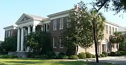 Winyah Indigo School |
November 3, 1988 (#88002386) |
1200 Highmarket St. 33°22′22″N 79°17′11″W |
Georgetown |
Former listing
| [3] | Name on the Register | Image | Date listed | Date removed | Location | City or town | Summary |
|---|---|---|---|---|---|---|---|
| 1 | China Grove | March 25, 1982 (#82003851) | March 15, 2000 | Georgetown | Burned |
See also
| Wikimedia Commons has media related to National Register of Historic Places in Georgetown County, South Carolina. |
References
- The latitude and longitude information provided in this table was derived originally from the National Register Information System, which has been found to be fairly accurate for about 99% of listings. Some locations in this table may have been corrected to current GPS standards.
- "National Register of Historic Places: Weekly List Actions". National Park Service, United States Department of the Interior. Retrieved on January 29, 2021.
- Numbers represent an alphabetical ordering by significant words. Various colorings, defined here, differentiate National Historic Landmarks and historic districts from other NRHP buildings, structures, sites or objects.
- "National Register Information System". National Register of Historic Places. National Park Service. March 13, 2009.
- The eight-digit number below each date is the number assigned to each location in the National Register Information System database, which can be viewed by clicking the number.
| Topics | 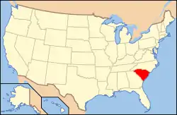 | |
|---|---|---|
| Lists by county |
| |
| Lists by city |
| |
| Other lists | ||
Municipalities and communities of Georgetown County, South Carolina, United States | ||
|---|---|---|
| City | Map of South Carolina highlighting Georgetown County | |
| Towns | ||
| CDP | ||
| Unincorporated communities | ||
| Footnotes | ‡This populated place also has portions in an adjacent county or counties | |
| ||