National Register of Historic Places listings in Greenville County, South Carolina
This is a list of the National Register of Historic Places listings in Greenville County, South Carolina outside the city of Greenville.
This is intended to be a complete list of the properties and districts on the National Register of Historic Places in Greenville County, South Carolina, United States. The locations of National Register properties and districts for which the latitude and longitude coordinates are included below, may be seen in a map.[1]
There are 86 properties and districts listed on the National Register in the county. Listings in the city of Greenville are listed separately, while the 43 properties and districts in the remaining parts of the county are listed here. Another property in Greenville County outside Greenville was once listed but has been removed.
- This National Park Service list is complete through NPS recent listings posted January 29, 2021.[2]
Current listings
| [3] | Name on the Register[4] | Image | Date listed[5] | Location | City or town | Description |
|---|---|---|---|---|---|---|
| 1 | American Spinning Company Mill No. 2 | 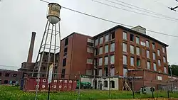 American Spinning Company Mill No. 2 |
October 18, 2016 (#16000730) |
300 Hammett St. 34°52′24″N 82°24′44″W |
Greenville | |
| 2 | Arthur Barnwell House | .jpg.webp) Arthur Barnwell House |
March 19, 1982 (#82003867) |
South of Greer on South Carolina Highway 14 34°51′18″N 82°13′41″W |
Greer | |
| 3 | William Bates House |  William Bates House |
December 4, 1978 (#78002512) |
East of Greenville on South Carolina Highway 14 34°50′53″N 82°14′04″W |
Greenville | |
| 4 | Brandon Mill |  Brandon Mill |
September 3, 2014 (#14000317) |
25 Draper St. 34°50′39″N 82°25′53″W |
Greenville | |
| 5 | Burdette Building |  Burdette Building |
July 17, 2003 (#03000660) |
104 E. Curtis St. 34°44′14″N 82°15′19″W |
Simpsonville | |
| 6 | Campbell's Covered Bridge | .jpg.webp) Campbell's Covered Bridge |
July 1, 2009 (#09000483) |
123 Campbell Covered Bridge Rd. 35°05′09″N 82°15′51″W |
Gowensville | |
| 7 | Cannon Building |  Cannon Building |
September 28, 2005 (#05001100) |
100 N. Main St. 34°41′37″N 82°11′59″W |
Fountain Inn | |
| 8 | Conestee Mill | 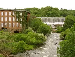 Conestee Mill |
March 2, 2014 (#09000913) |
1 Spanco Dr. 34°46′13″N 82°20′51″W |
Conestee | |
| 9 | Cureton-Huff House |  Cureton-Huff House |
January 13, 1983 (#83002196) |
Southwest of Simpsonville off S-272 (West Georgia Road) 34°41′34″N 82°20′02″W |
Simpsonville | |
| 10 | Davenport House |  Davenport House |
February 1, 1999 (#98001623) |
100 Randall St. 34°56′10″N 82°13′37″W |
Greer | |
| 11 | Dunean Mill Historic District | February 4, 2019 (#100003418) |
Bounded by Madden, Allen, Whitten & Hutchins Sts. 34°49′35″N 82°25′16″W |
Dunean | ||
| 12 | Fairview Presbyterian Church | 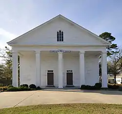 Fairview Presbyterian Church |
August 16, 1977 (#77001224) |
West of Fountain Inn off South Carolina Highway 418 34°38′37″N 82°15′05″W |
Fountain Inn | |
| 13 | Fountain Inn High School | 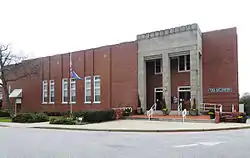 Fountain Inn High School |
June 3, 2009 (#09000390) |
315 N. Main St. 34°41′44″N 82°12′06″W |
Fountain Inn | |
| 14 | Fountain Inn Principal's House and Teacherage | 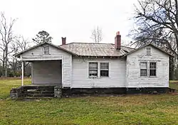 Fountain Inn Principal's House and Teacherage |
June 27, 2011 (#11000415) |
105 Mt. Zion Dr. 34°41′47″N 82°11′33″W |
Fountain Inn | |
| 15 | James A. Fulmer House |  James A. Fulmer House |
October 5, 2015 (#15000706) |
303 N. Main St. 34°41′45″N 82°12′06″W |
Fountain Inn | |
| 16 | Gilreath's Mill | .jpg.webp) Gilreath's Mill |
May 28, 1976 (#76001703) |
4 miles northwest of Greer on South Carolina Highway 101 34°58′23″N 82°16′44″W |
Greer | |
| 17 | John H. Goodwin House | 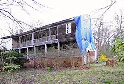 John H. Goodwin House |
September 8, 1983 (#83002197) |
South Carolina Highway 11 at U.S. Route 25 35°05′19″N 82°27′08″W |
Travelers Rest | |
| 18 | Greer Depot | 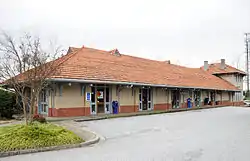 Greer Depot |
March 6, 1987 (#87000409) |
311 Trade St. 34°56′10″N 82°13′33″W |
Greer | |
| 19 | Greer Downtown Historic District | 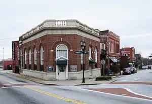 Greer Downtown Historic District |
September 18, 1997 (#97001156) |
Roughly bounded by Trade, E. Poinsett, Randall, Victoria, and N. Main Sts.; Roughly along Trade St., E. Poinsett St., and N. Main St. 34°56′16″N 82°13′43″W |
Greer | Second set of addresses represent boundary changes approved September 30, 2019. |
| 20 | Greer Post Office | 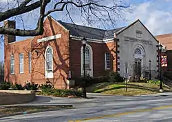 Greer Post Office |
January 31, 2011 (#10001184) |
106 S Main St. 34°56′19″N 82°13′38″W |
Greer | |
| 21 | Holly Springs School | October 7, 2019 (#100004494) |
130 Holly Springs Rd. 34°34′41″N 82°23′48″W |
Belton vicinity | ||
| 22 | Hopkins Farm |  Hopkins Farm |
September 20, 2007 (#07000987) |
3717 Fork Shoals Rd. 34°38′53″N 82°18′30″W |
Simpsonville | |
| 23 | Louie James House |  Louie James House |
September 19, 1996 (#96000985) |
401 W. Poinsett St. 34°56′25″N 82°14′05″W |
Greer | |
| 24 | Judson Mill | February 5, 2018 (#100002084) |
701 Easley Bridge Rd. 34°50′13″N 82°25′39″W |
Greenville | ||
| 25 | McBee Methodist Church |  McBee Methodist Church |
March 23, 1972 (#72001212) |
Main St. 34°46′00″N 82°21′10″W |
Conestee | |
| 26 | McDowell House |  McDowell House |
November 17, 2010 (#10000921) |
500 N Main St. 34°41′53″N 82°12′17″W |
Fountain Inn | |
| 27 | Monaghan Mill | .JPG.webp) Monaghan Mill |
October 4, 2005 (#05001159) |
201 Smythe St. 34°52′00″N 82°25′27″W |
City View | |
| 28 | Old Pilgrim Baptist Church Cemetery and Kilgore Family Cemetery |  Old Pilgrim Baptist Church Cemetery and Kilgore Family Cemetery |
February 28, 2017 (#100000688) |
3540 Woodruff Rd. 34°47′36″N 82°11′46″W |
Simpsonville | |
| 29 | Paris Mountain State Park Historic District | .jpg.webp) Paris Mountain State Park Historic District |
April 30, 1998 (#98000416) |
2401 State Park Rd. 34°56′25″N 82°23′39″W |
Greenville | |
| 30 | Pelham Mills Site (38GR165) | .jpg.webp) Pelham Mills Site (38GR165) |
November 19, 1987 (#87001954) |
South of Greer on South Carolina Highway 14 34°51′25″N 82°13′36″W |
Pelham | |
| 31 | Piedmont Mill Stores Building |  Piedmont Mill Stores Building |
March 16, 2020 (#100005071) |
2-8 Main St. 34°42′15″N 82°27′44″W |
Piedmont | |
| 32 | Poinsett Bridge | 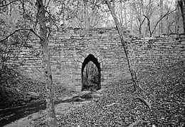 Poinsett Bridge |
October 22, 1970 (#70000590) |
About 4 miles north of Tigerville on County Road 42 35°07′47″N 82°23′06″W |
Tigerville | |
| 33 | Robert Quillen Office and Library | 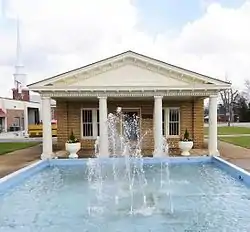 Robert Quillen Office and Library |
January 30, 2012 (#10000316) |
200 N. Main St. 34°41′40″N 82°12′01″W |
Fountain Inn | |
| 34 | George Salmon House | 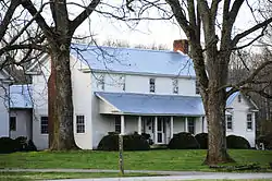 George Salmon House |
January 21, 1988 (#87002520) |
South Carolina Highway 414, 1.8 miles west of U.S. Route 25 35°02′07″N 82°27′31″W |
Travelers Rest | |
| 35 | Simpsonville Baptist Church |  Simpsonville Baptist Church |
October 13, 1992 (#92001309) |
106 Church St. 34°44′21″N 82°15′10″W |
Simpsonville | |
| 36 | Southern Bleachery and Print Works | 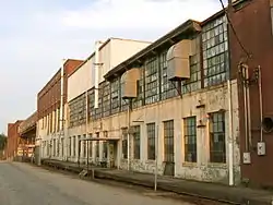 Southern Bleachery and Print Works |
July 25, 2012 (#12000439) |
113 Mill St. 34°55′12″N 82°17′21″W |
Taylors | |
| 37 | Spring Park Inn | February 1, 2018 (#100002085) |
301 Old Buncombe Rd. 34°57′45″N 82°26′28″W |
Travelers Rest | ||
| 38 | Earle R. Taylor House and Peach Packing Shed | 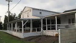 Earle R. Taylor House and Peach Packing Shed |
June 27, 2012 (#12000372) |
1001 Locust Hill Rd. 34°56′52″N 82°15′46″W |
Greer | |
| 39 | Tullyton |  Tullyton |
July 31, 1990 (#89002151) |
606 Hickory Tavern Rd. 34°36′24″N 82°13′57″W |
Fountain Inn | |
| 40 | R. Perry Turner House |  R. Perry Turner House |
February 1, 1999 (#98001624) |
211 N. Main St. 34°56′29″N 82°13′31″W |
Greer | |
| 41 | Robert G. Turner House |  Robert G. Turner House |
February 1, 1999 (#98001625) |
305 N. Main St. 34°56′34″N 82°13′30″W |
Greer | |
| 42 | F. W. Welborn House | 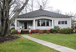 F. W. Welborn House |
November 23, 2010 (#10000920) |
405 N. Weston St. 34°41′51″N 82°12′09″W |
Fountain Inn | |
| 43 | Woodside Cotton Mill Village Historic District |  Woodside Cotton Mill Village Historic District |
April 30, 1987 (#87000678) |
Woodside Ave. and E. Main St. 34°51′12″N 82°25′47″W |
Woodside |
Former listing
| [3] | Name on the Register | Image | Date listed | Date removed | Location | City or town | Summary |
|---|---|---|---|---|---|---|---|
| 1 | Piedmont Manufacturing Company | .jpg.webp) Piedmont Manufacturing Company |
June 2, 1978 (#78002516) | March 5, 1986 | Main Street 34°51′12″N 82°25′47″W |
Piedmont | Burned in 1983. |
See also
| Wikimedia Commons has media related to National Register of Historic Places in Greenville County, South Carolina. |
References
- The latitude and longitude information provided in this table was derived originally from the National Register Information System, which has been found to be fairly accurate for about 99% of listings. Some locations in this table may have been corrected to current GPS standards.
- "National Register of Historic Places: Weekly List Actions". National Park Service, United States Department of the Interior. Retrieved on January 29, 2021.
- Numbers represent an alphabetical ordering by significant words. Various colorings, defined here, differentiate National Historic Landmarks and historic districts from other NRHP buildings, structures, sites or objects.
- "National Register Information System". National Register of Historic Places. National Park Service. March 13, 2009.
- The eight-digit number below each date is the number assigned to each location in the National Register Information System database, which can be viewed by clicking the number.
| Topics |  | |
|---|---|---|
| Lists by county |
| |
| Lists by city |
| |
| Other lists | ||
Municipalities and communities of Greenville County, South Carolina, United States | ||
|---|---|---|
| Cities | Map of South Carolina highlighting Greenville County | |
| CDPs | ||
| Unincorporated communities | ||
| Footnotes | ‡This populated place also has portions in an adjacent county or counties | |
| ||