National Register of Historic Places listings in Pickens County, South Carolina
This is a list of the National Register of Historic Places listings in Pickens County, South Carolina.
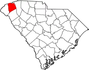
Location of Pickens County in South Carolina
This is intended to be a complete list of the properties and districts on the National Register of Historic Places in Pickens County, South Carolina, United States. The locations of National Register properties and districts for which the latitude and longitude coordinates are included below, may be seen in a map.[1]
There are 29 properties and districts listed on the National Register in the county, including 1 National Historic Landmark.
- This National Park Service list is complete through NPS recent listings posted February 5, 2021.[2]
Current listings
| [3] | Name on the Register[4] | Image | Date listed[5] | Location | City or town | Description |
|---|---|---|---|---|---|---|
| 1 | Central High School | .JPG.webp) Central High School |
May 20, 1994 (#94000475) |
304 Church St. 34°43′22″N 82°46′52″W |
Central | |
| 2 | Central Roller Mills | 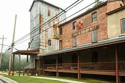 Central Roller Mills |
June 25, 2013 (#13000454) |
300 Madden Bridge Rd. 34°43′29″N 82°47′05″W |
Central | |
| 3 | Civilian Conservation Corps Quarry No. 1 and Truck Trail | June 16, 1989 (#89000479) |
Off Section Rd. 25/Hickory Hollow Rd., 0.7 miles south of South Carolina Highway 11 35°00′17″N 82°42′46″W |
Pickens | ||
| 4 | Civilian Conservation Corps Quarry No. 2 | 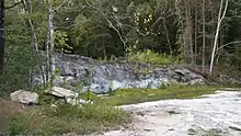 Civilian Conservation Corps Quarry No. 2 |
June 16, 1989 (#89000480) |
0.2 miles north of Section Rd. 69/Sliding Rock Rd. near the Oolenoy River 35°00′21″N 82°43′18″W |
Pickens | Granite outcropping, located on private property adjacent to Blue Hills Trail, off Sliding Rock Road |
| 5 | Clemson College Sheep Barn | .JPG.webp) Clemson College Sheep Barn |
January 4, 1990 (#89002140) |
S. Palmetto Boulevard on the Clemson University campus 34°40′36″N 82°49′50″W |
Clemson | |
| 6 | Clemson University Historic District I |  Clemson University Historic District I |
January 4, 1990 (#89002138) |
Northern portion of campus along U.S. Route 76 34°40′47″N 82°50′04″W |
Clemson | |
| 7 | Clemson University Historic District II | 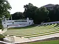 Clemson University Historic District II |
January 4, 1990 (#89002139) |
Center of campus 34°40′40″N 82°50′18″W |
Clemson | |
| 8 | Easley High School Auditorium |  Easley High School Auditorium |
January 21, 1999 (#98001646) |
112 Russell St. 34°50′N 82°36′W |
Easley | |
| 9 | Easley Mill |  Easley Mill |
September 23, 2013 (#09000818) |
601 S. 5th St., 34°49′27″N 82°36′28″W |
Easley | |
| 10 | Fort Hill | 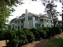 Fort Hill |
October 15, 1966 (#66000708) |
Clemson University campus 34°40′40″N 82°50′21″W |
Clemson | |
| 11 | Griffin-Christopher House | 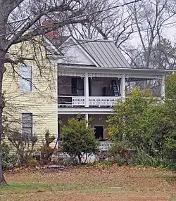 Griffin-Christopher House |
October 21, 2001 (#01001160) |
208 Ann St. 34°53′06″N 82°42′30″W |
Pickens | |
| 12 | Hagood Mill | .jpg.webp) Hagood Mill |
December 11, 1972 (#72001217) |
3.5 miles northwest of Pickens on U.S. Route 178 34°55′37″N 82°43′20″W |
Pickens | Includes Hagood Creek Petroglyph Site |
| 13 | Hagood-Mauldin House | .JPG.webp) Hagood-Mauldin House |
October 9, 1997 (#97001185) |
104 N. Lewis St. 34°53′07″N 82°42′20″W |
Pickens | |
| 14 | Hanover House | .JPG.webp) Hanover House |
June 5, 1970 (#70000594) |
Clemson University campus 34°40′35″N 82°49′52″W |
Clemson | |
| 15 | Hester Store | 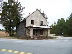 Hester Store |
February 5, 2013 (#12001263) |
1735 Hester Store Rd. 34°53′48″N 82°32′20″W |
Dacusville | |
| 16 | Liberty Colored High School | .JPG.webp) Liberty Colored High School |
April 18, 2003 (#03000270) |
Junction of South Carolina Highway 93 and Rosewood St. 34°47′23″N 82°41′23″W |
Liberty | |
| 17 | Morgan House | 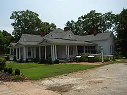 Morgan House |
March 29, 2001 (#01000312) |
416 Church St. 34°43′20″N 82°46′49″W |
Central | |
| 18 | Old Pickens Jail | .JPG.webp) Old Pickens Jail |
April 11, 1979 (#79002390) |
Johnson and Pendleton Sts. 34°52′51″N 82°42′21″W |
Pickens | |
| 19 | Old Stone Church and Cemetery | .JPG.webp) Old Stone Church and Cemetery |
November 5, 1971 (#71000794) |
1.5 miles north of Pendleton off U.S. Route 76 34°39′49″N 82°48′58″W |
Pendleton | |
| 20 | Oolenoy Baptist Church Cemetery | 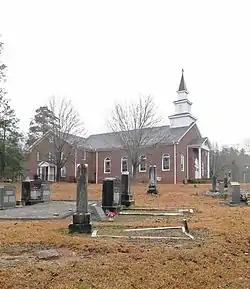 Oolenoy Baptist Church Cemetery |
October 14, 2003 (#03000659) |
201 Miracle Hill Rd. 34°59′30″N 82°48′21″W |
Pickens | |
| 21 | Pendleton Historic District | .JPG.webp) Pendleton Historic District |
August 25, 1970 (#70000560) |
Bounded on the west by Hopewell and Treaty Oak, on the north by the Old Stone Church, on the east by Montpelier, and on the south by the town limits 34°39′06″N 82°47′02″W |
Pendleton | Extends into Anderson and Oconee counties |
| 22 | Roper House Complex |  Roper House Complex |
June 16, 1989 (#89000482) |
Section Road 25, 0.1 miles southeast of South Carolina Highway 11 35°01′18″N 82°41′32″W |
Pickens | |
| 23 | Sheriff Mill Complex |  Sheriff Mill Complex |
November 20, 1987 (#87002058) |
South Carolina Highway 40 34°47′18″N 82°34′08″W |
Easley | |
| 24 | J. Warren Smith House | .JPG.webp) J. Warren Smith House |
January 26, 2005 (#04001564) |
21 N. Palmetto St. 34°47′09″N 82°41′47″W |
Liberty | |
| 25 | J. C. Stribling Barn | .JPG.webp) J. C. Stribling Barn |
October 22, 2001 (#01001161) |
220 Issaqueena Trail 34°40′07″N 82°47′45″W |
Clemson | |
| 26 | Structural Science Building | .JPG.webp) Structural Science Building |
April 5, 2010 (#09000365) |
Palmetto Boulevard and Fernow Drive 34°40′31″N 82°50′18″W |
Clemson | Now known as Lee and Lowry Halls; built in 1958 and designed by Harlan Ewart McClure, the first dean of architecture at Clemson University[6] |
| 27 | Table Rock Civilian Conservation Corps Camp Site |  Table Rock Civilian Conservation Corps Camp Site |
June 16, 1989 (#89000481) |
Table Rock State Park Rd. Extension at South Carolina Highway 11 35°01′18″N 82°41′55″W |
Pickens | |
| 28 | Table Rock State Park Historic District |  Table Rock State Park Historic District |
June 15, 1989 (#89000478) |
South Carolina Highway 11, 4.5 miles east of Primary Road 45 35°02′07″N 82°42′31″W |
Pickens | |
| 29 | Williams-Ligon House | February 8, 2012 (#12000015) |
1866 Farrs Bridge Rd. 34°54′10″N 82°37′03″W |
Easley |
See also
| Wikimedia Commons has media related to National Register of Historic Places in Pickens County, South Carolina. |
References
- The latitude and longitude information provided in this table was derived originally from the National Register Information System, which has been found to be fairly accurate for about 99% of listings. Some locations in this table may have been corrected to current GPS standards.
- "National Register of Historic Places: Weekly List Actions". National Park Service, United States Department of the Interior. Retrieved on February 5, 2021.
- Numbers represent an alphabetical ordering by significant words. Various colorings, defined here, differentiate National Historic Landmarks and historic districts from other NRHP buildings, structures, sites or objects.
- "National Register Information System". National Register of Historic Places. National Park Service. March 13, 2009.
- The eight-digit number below each date is the number assigned to each location in the National Register Information System database, which can be viewed by clicking the number.
- "Clemson's Lee Hall/Lowry Hall Listed on National Register of Historic Places". Washington, DC. Targeted News Service. June 1, 2010. ProQuest Document ID 2048606741.
| Topics | 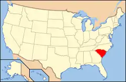 | |
|---|---|---|
| Lists by county |
| |
| Lists by city |
| |
| Other lists | ||
Municipalities and communities of Pickens County, South Carolina, United States | ||
|---|---|---|
| Cities | Map of South Carolina highlighting Pickens County | |
| Towns | ||
| CDP | ||
| Unincorporated communities | ||
| Footnotes | ‡This populated place also has portions in an adjacent county or counties | |
| ||
This article is issued from Wikipedia. The text is licensed under Creative Commons - Attribution - Sharealike. Additional terms may apply for the media files.