National Register of Historic Places listings in Greenwood County, South Carolina
This is a list of the National Register of Historic Places listings in Greenwood County, South Carolina.

Location of Greenwood County in South Carolina
This is intended to be a complete list of the properties and districts on the National Register of Historic Places in Greenwood County, South Carolina, United States. The locations of National Register properties and districts for which the latitude and longitude coordinates are included below, may be seen in a map.[1]
There are 21 properties and districts listed on the National Register in the county, including 1 National Historic Landmark. Another property was once listed but has been removed.
- This National Park Service list is complete through NPS recent listings posted January 29, 2021.[2]
Current listings
| [3] | Name on the Register[4] | Image | Date listed[5] | Location | City or town | Description |
|---|---|---|---|---|---|---|
| 1 | Barratt House | 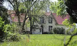 Barratt House |
September 12, 1985 (#85002382) |
South Carolina Highway 67 and Bryan Dorn Rd. 34°06′37″N 82°07′39″W |
Greenwood | |
| 2 | J. Wesley Brooks House |  J. Wesley Brooks House |
March 30, 1973 (#73001712) |
2 miles south of Greenwood on U.S. Route 25 34°08′18″N 82°07′48″W |
Greenwood | |
| 3 | Greenville Presbyterian Church | 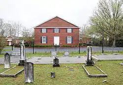 Greenville Presbyterian Church |
May 20, 1998 (#98000561) |
Greenville Church Rd. 34°20′50″N 82°18′14″W |
Donalds | |
| 4 | Kinard House |  Kinard House |
March 7, 2007 (#07000119) |
227 W. Main St. 34°10′27″N 82°01′42″W |
Ninety Six | |
| 5 | Lander College Old Main Building | 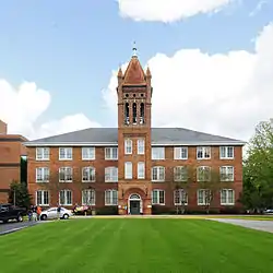 Lander College Old Main Building |
August 2, 1984 (#84002046) |
Stanley Ave. and Lander St. 34°11′54″N 82°09′52″W |
Greenwood | |
| 6 | Magnolia Cemetery | 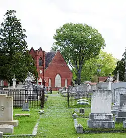 Magnolia Cemetery |
June 9, 2004 (#04000590) |
416 Magnolia Ave. 34°11′27″N 82°09′16″W |
Greenwood | |
| 7 | Moore-Kinard House |  Moore-Kinard House |
August 4, 1983 (#83002198) |
U.S. Route 178 and S-24-44 34°05′18″N 82°02′34″W |
Ninety Six | |
| 8 | Mt. Pisgah A.M.E. Church | 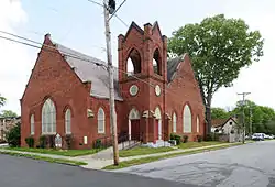 Mt. Pisgah A.M.E. Church |
August 16, 1979 (#79002384) |
Hackett Ave. and James St. 34°11′29″N 82°09′12″W |
Greenwood | |
| 9 | Ninety Six National Historic Site |  Ninety Six National Historic Site |
December 3, 1969 (#69000169) |
2 miles south of Ninety Six between South Carolina Highways 27 and 248 34°09′19″N 82°00′46″W |
Ninety Six | |
| 10 | The Oaks | 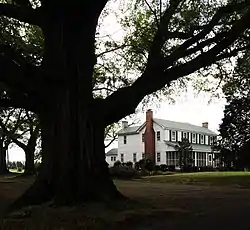 The Oaks |
December 17, 2010 (#10001040) |
114 Old Puckett's Ferry Rd. 34°15′25″N 82°05′05″W |
Coronaca vicinity | |
| 11 | Old Cokesbury and Masonic Female College and Conference School | 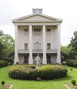 Old Cokesbury and Masonic Female College and Conference School |
August 25, 1970 (#70000589) |
North of Greenwood at the junction of South Carolina Highways 246 and 254 34°16′29″N 82°13′03″W |
Cokesbury | |
| 12 | Old Greenwood Cemetery | 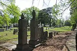 Old Greenwood Cemetery |
March 1, 2002 (#02000115) |
503 E. Cambridge Ave. 34°11′50″N 82°09′12″W |
Greenwood | |
| 13 | Old Greenwood High School |  Old Greenwood High School |
October 10, 1985 (#85003120) |
857 S. Main St. 34°11′08″N 82°09′29″W |
Greenwood | |
| 14 | James C. Self House | 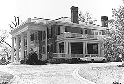 James C. Self House |
November 20, 1987 (#87002064) |
595 N. Mathis St. 34°11′38″N 82°10′54″W |
Greenwood | |
| 15 | Southern Railway Depot |  Southern Railway Depot |
October 6, 2011 (#11000731) |
99 South Carolina Highway 34 34°10′29″N 82°01′27″W |
Ninety Six | |
| 16 | Stony Point | .jpg.webp) Stony Point |
June 20, 1975 (#75001700) |
North of Greenwood at the junction of South Carolina Highways 39 and 246 34°16′44″N 82°07′33″W |
Greenwood | |
| 17 | Sunnyside | 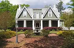 Sunnyside |
November 14, 1978 (#78002515) |
105 Dargan Ave. 34°11′07″N 82°09′08″W |
Greenwood | |
| 18 | Tabernacle Cemetery | 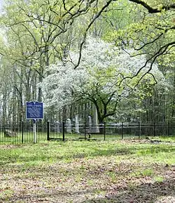 Tabernacle Cemetery |
August 1, 2008 (#08000736) |
Tabernacle Cemetery Rd., just east of South Carolina Highway 254 34°16′00″N 82°11′02″W |
Greenwood | |
| 19 | Trapp and Chandler Pottery Site (38GN169) | January 6, 1986 (#86000043) |
Address Restricted |
Kirksey | ||
| 20 | Vance-Maxwell House | 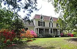 Vance-Maxwell House |
March 5, 1982 (#82003866) |
158 E. Cambridge St. 34°11′42″N 82°09′33″W |
Greenwood | |
| 21 | Ware Shoals Inn | 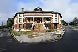 Ware Shoals Inn |
November 1, 2007 (#07001130) |
1 Greenwood Ave., N. 34°23′38″N 82°14′49″W |
Ware Shoals |
Former listing
| [3] | Name on the Register | Image | Date listed | Date removed | Location | City or town | Summary |
|---|---|---|---|---|---|---|---|
| 1 | Benjamin Mays Birthplace |  Benjamin Mays Birthplace |
May 18, 1998 (#98000414) | December 8, 2005 | 0.5 mi NW of jct. of US 179 and Scott Ferry Rd. |
Epworth | Moved to Greenwood |
See also
| Wikimedia Commons has media related to National Register of Historic Places in Greenwood County, South Carolina. |
References
- The latitude and longitude information provided in this table was derived originally from the National Register Information System, which has been found to be fairly accurate for about 99% of listings. Some locations in this table may have been corrected to current GPS standards.
- "National Register of Historic Places: Weekly List Actions". National Park Service, United States Department of the Interior. Retrieved on January 29, 2021.
- Numbers represent an alphabetical ordering by significant words. Various colorings, defined here, differentiate National Historic Landmarks and historic districts from other NRHP buildings, structures, sites or objects.
- "National Register Information System". National Register of Historic Places. National Park Service. March 13, 2009.
- The eight-digit number below each date is the number assigned to each location in the National Register Information System database, which can be viewed by clicking the number.
| Topics | 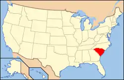 | |
|---|---|---|
| Lists by county |
| |
| Lists by city |
| |
| Other lists | ||
Municipalities and communities of Greenwood County, South Carolina, United States | ||
|---|---|---|
| City | Map of South Carolina highlighting Greenwood County | |
| Towns | ||
| CDPs | ||
| Unincorporated community | ||
| Footnotes | ‡This populated place also has portions in an adjacent county or counties | |
| ||
This article is issued from Wikipedia. The text is licensed under Creative Commons - Attribution - Sharealike. Additional terms may apply for the media files.