Snyder County, Pennsylvania
Snyder County is a county in the U.S. state of Pennsylvania. As of the 2010 census, the population was 39,702.[1] The county seat is Middleburg.[2] Snyder County was formed in 1855 from parts of Union County.
Snyder County | |
|---|---|
.jpg.webp) Snyder County Courthouse | |
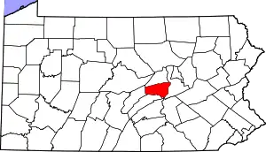 Location within the U.S. state of Pennsylvania | |
 Pennsylvania's location within the U.S. | |
| Coordinates: 40°46′N 77°05′W | |
| Country | |
| State | |
| Founded | March 2, 1855 |
| Named for | Simon Snyder |
| Seat | Middleburg |
| Largest borough | Selinsgrove |
| Area | |
| • Total | 332 sq mi (860 km2) |
| • Land | 329 sq mi (850 km2) |
| • Water | 2.8 sq mi (7 km2) 0.8%% |
| Population | |
| • Estimate (2018) | 40,540 |
| • Density | 123/sq mi (47/km2) |
| Time zone | UTC−5 (Eastern) |
| • Summer (DST) | UTC−4 (EDT) |
| Area code | 570 & 272, 717 & 223 |
| Congressional district | 12th |
| Website | www |
Snyder County comprises the Selinsgrove, PA Micropolitan Statistical Area, which is also included in the Bloomsburg-Berwick-Sunbury, PA Combined Statistical Area.
History
Snyder County was settled in the 1740s by Pennsylvania Germans from Berks and Lancaster counties, and became an independent political unit on March 2, 1855, when formed under part of Union County. Snyder County took its name in honor of the famous citizen and political figure Simon Snyder, who was governor of Pennsylvania for three terms, from 1808 to 1817, and made his home in Selinsgrove. The county seat of Middleburg was laid out in 1800 and incorporated in 1864.[3]
Geography
According to the U.S. Census Bureau, the county has a total area of 332 square miles (860 km2), of which 329 square miles (850 km2) is land and 2.8 square miles (7.3 km2) (0.8%) is water.[4] It is the fifth-smallest county in Pennsylvania by area. Snyder County is in the Ridge and Valley region of the Appalachian Mountains. Two parallel mountain ridges, Shade Mountain and Jacks Mountain, run southwest to northeast. The Susquehanna River is the eastern border. Between the ridges are steep hills, gently rolling hills, and flat creek valleys. With over 400 active farms in the county, agriculture plays an important role in the economy and environment. Roughly half the county remains forested with both softwoods and hardwoods. These woods provide a place for wildlife to roam which provides for the sport of hunting.
Climate
Snyder has a humid continental climate which is hot-summer (Dfa) except in higher areas where it is warm-summer (Dfb). Average temperatures in Selinsgrove range from 27.4 °F in January to 72.8 °F in July, while in Beavertown they range from 26.6 °F in January to 72.1 °F in July.
Adjacent counties
- Union County (north)
- Northumberland County (east)
- Juniata County (south)
- Mifflin County (west)
Demographics
| Historical population | |||
|---|---|---|---|
| Census | Pop. | %± | |
| 1860 | 15,035 | — | |
| 1870 | 15,606 | 3.8% | |
| 1880 | 17,797 | 14.0% | |
| 1890 | 17,651 | −0.8% | |
| 1900 | 17,304 | −2.0% | |
| 1910 | 16,800 | −2.9% | |
| 1920 | 17,129 | 2.0% | |
| 1930 | 18,836 | 10.0% | |
| 1940 | 20,208 | 7.3% | |
| 1950 | 22,912 | 13.4% | |
| 1960 | 25,922 | 13.1% | |
| 1970 | 29,269 | 12.9% | |
| 1980 | 33,584 | 14.7% | |
| 1990 | 36,680 | 9.2% | |
| 2000 | 37,546 | 2.4% | |
| 2010 | 39,702 | 5.7% | |
| 2018 (est.) | 40,540 | [5] | 2.1% |
| U.S. Decennial Census[6] 1790–1960[7] 1900–1990[8] 1990–2000[9] 2010–2017[1] | |||
According to the 2010 federal census, there were 39,702 people, 14,414 households, and 9,981 families residing in the county. The population density was 113 people per square mile (44/km2). There were 14,890 housing units at an average density of 45 per square mile (17/km2). The racial makeup of the county was 97% White, 1.2% Black or African American, 0.1% Native American, 0.42% Asian, and 0.07% Pacific Islander. Two percent of the population were Hispanic or Latino. US Veterans – 2,681. Median household income (in 2014 dollars), 2010–2014 was reported as $48,718, while the per capita income was $23,886.[10] In 2014, the median household income in the USA was $53,700.[11]
As of the census[12] of 2000, there were 37,546 people, 13,654 households, and 9,981 families residing in the county. The population density was 113 people per square mile (44/km2). There were 14,890 housing units at an average density of 45 per square mile (17/km2). The racial makeup of the county was 97.93% White, 0.82% Black or African American, 0.05% Native American, 0.42% Asian, 0.01% Pacific Islander. 0.98% of the population were Hispanic or Latino of any race. 48.2% were of German, 17.2% American and 5.5% English ancestry.
There were 13,654 households, out of which 32.10% had children under the age of 18 living with them, 62.00% were married couples living together, 7.40% had a female householder with no husband present, and 26.90% were non-families. 22.40% of all households were made up of individuals, and 10.30% had someone living alone who was 65 years of age or older. The average household size was 2.58 and the average family size was 3.02.
In the county, the population was spread out, with 24.00% under the age of 18, 11.20% from 18 to 24, 27.40% from 25 to 44, 23.30% from 45 to 64, and 14.00% who were 65 years of age or older. The median age was 37 years. For every 100 females there were 95.60 males. For every 100 females age 18 and over, there were 93.10 males.
The average wage per job reported for 2003 was $26,650. County population in 2003 had risen to 37,965. Jobs in 2003 were 17,907, with a total labor force in 2004 of 19,863. The unemployment rate in 2004 was reported at 4.8%. Average household size in Snyder County in 2004 was 2.58.
- County poverty demographics
According to research by The Center for Rural Pennsylvania, which is a legislative agency of the Pennsylvania General Assembly, the poverty rate for Snyder County was 13.1% in 2014.[13] The statewide poverty rate was 13.6% in 2014. The 2012 childhood poverty rate by public school district was: Midd-West School District – 47.1% living at 185% or below than the Federal Poverty Level, and Selinsgrove Area School District – 39.5%.[14]
According to the US Census Bureau, from 2009-2014 Snyder County saw a 51% increase in the number of families in the federal food assistance program called SNAP (Supplemental Nutrition Assistance Program).[15] The number of people or families receiving monthly SNAP dollars rose from 1,006 in 2009 to 1,511 people in 2014.[16]
- Teen pregnancy rate
The Pennsylvania Department of Health reports the annual teens aged 15–19 birth rate. From 2011 to 2015, Snyder County experienced a 17% decline in teen pregnancies.[17] In Pennsylvania the majority of pupils graduate from high school at age 18 years old. Snyder County is home to a large Amish population where pregnancies at 17–19 years old are common.
- 2015 – 228
- 2014 – 239
- 2013 – 258
- 2012 – 263
- 2011 – 274
Micropolitan Statistical Area
The United States Office of Management and Budget[18] has designated Snyder County as the Selinsgrove, PA Micropolitan Statistical Area (µSA). As of the 2010 census[19] the micropolitan area ranked 15th most populous in the State of Pennsylvania and the 313th most populous in the United States with a population of 39,702. Snyder County is also a part of the Bloomsburg–Berwick–Sunbury, PA Combined Statistical Area (CSA), which combines the populations of Snyder County, as well as Columbia, Montour, Northumberland and Union Counties in Pennsylvania. The Combined Statistical Area ranked 8th in the State of Pennsylvania and 115th most populous in the United States with a population of 264,739.
Politics
| Year | Republican | Democratic | Third parties |
|---|---|---|---|
| 2020 | 72.9% 13,983 | 25.6% 4,910 | 1.5% 288 |
| 2016 | 71.1% 11,725 | 24.3% 4,002 | 4.6% 759 |
| 2012 | 66.9% 10,073 | 31.1% 4,687 | 2.0% 308 |
| 2008 | 63.6% 9,900 | 34.6% 5,382 | 1.8% 284 |
| 2004 | 70.5% 10,566 | 29.0% 4,348 | 0.5% 69 |
| 2000 | 69.8% 8,963 | 27.5% 3,536 | 2.7% 342 |
| 1996 | 57.9% 6,742 | 29.3% 3,405 | 12.8% 1,495 |
| 1992 | 55.1% 6,934 | 23.4% 2,952 | 21.5% 2,710 |
| 1988 | 76.9% 9,054 | 22.6% 2,658 | 0.6% 67 |
| 1984 | 78.7% 8,968 | 20.9% 2,383 | 0.4% 40 |
| 1980 | 72.1% 7,634 | 22.8% 2,418 | 5.1% 539 |
| 1976 | 66.0% 6,557 | 31.2% 3,097 | 2.8% 275 |
| 1972 | 78.2% 7,308 | 19.6% 1,834 | 2.2% 203 |
| 1968 | 71.6% 6,784 | 21.1% 1,993 | 7.3% 692 |
| 1964 | 55.2% 5,195 | 44.6% 4,199 | 0.2% 22 |
| 1960 | 80.1% 8,103 | 19.8% 1,998 | 0.2% 16 |
| 1956 | 78.4% 7,102 | 21.6% 1,959 | 0.0% 3 |
| 1952 | 80.0% 6,836 | 19.7% 1,686 | 0.3% 23 |
| 1948 | 77.7% 5,181 | 22.3% 1,490 | |
| 1944 | 75.8% 5,696 | 23.9% 1,795 | 0.3% 23 |
| 1940 | 69.7% 5,722 | 30.2% 2,478 | 0.2% 14 |
| 1936 | 64.6% 5,550 | 34.9% 2,999 | 0.6% 49 |
| 1932 | 59.4% 3,423 | 37.7% 2,176 | 2.9% 167 |
| 1928 | 87.2% 5,693 | 12.3% 805 | 0.4% 29 |
| 1924 | 72.0% 3,055 | 22.9% 970 | 5.1% 218 |
| 1920 | 72.2% 2,751 | 25.3% 964 | 2.5% 95 |
| 1916 | 57.7% 1,797 | 40.1% 1,247 | 2.2% 68 |
| 1912 | 18.8% 626 | 29.8% 991 | 51.4% 1,713 |
| 1908 | 67.4% 2,401 | 30.4% 1,081 | 2.3% 80 |
| 1904 | 71.6% 2,538 | 27.4% 972 | 1.0% 37 |
| 1900 | 64.9% 2,517 | 34.0% 1,319 | 1.2% 45 |
| 1896 | 64.7% 2,572 | 34.0% 1,351 | 1.4% 55 |
| 1892 | 59.9% 2,307 | 39.3% 1,511 | 0.8% 32 |
| 1888 | 60.4% 2,360 | 38.2% 1,493 | 1.5% 57 |
The county is strongly Republican in presidential elections. The last Republican nominee to receive less than 60% of the county’s vote was Bob Dole. In 2008 John McCain received 64% of the county’s vote.[21] In the 1964 presidential election Snyder County was one of only four counties in Pennsylvania to vote for Barry Goldwater, and by 0.6 percentage points shaded Carroll County, New Hampshire as Goldwater’s strongest county in the Northeast.[22] The last Republican presidential candidate to lose Snyder County was incumbent president William Howard Taft when he split the Republican vote with challenger and former president Theodore Roosevelt, who took the county for the insurgent Progressive Party.[23] In fact, no Democratic presidential candidate has been able to claim the county since Pennsylvania native James Buchanan won the presidency in 1856. The only county in Pennsylvania to be more steadfastly Republican (or indeed, remain so one-sidedly partisan for either party in Pennsylvania) in presidential contests has been Snyder County's neighbor to the north, Union County, which voted for John C. Fremont over Buchanan in 1856.[24]
The county is located in Pennsylvania's 12th congressional district, which has a Cook Partisan Voting Index of R+17 and is represented by Republican Fred Keller. As part of Pennsylvania Senate, District 27 it is represented by Republican John Gordner. The county contains locations in Pennsylvania House of Representatives, District 82, Pennsylvania House of Representatives, District 85, and Pennsylvania House of Representatives, District 108. All of these have been represented by Republicans since 1989.
Of "Straight Party" voters in Snyder 73.2% are Republican and 24.65% are Democratic. In the 2008 election Republicans won in all races and in most they won by over 20%. Chris Carney lost by roughly 13% in the county[25] while winning by 12% in the district.
County commissioners
- Joseph Kantz, (R) Chairman
- Peggy Chamberlain Roup, (D) Secretary
- Lee Knepp, Vice-Chair, (R) Appointed by judge in January 2018 to serve out Derk Term[26]
Malcolm Derk, Resigned mid term, December 2017.[27]
Row offices
- Teresa J. Berger, Prothonotary and Clerk of Courts
- Michael Piecuch, District Attorney
- Stacy Zerbe, Register and Recorder
- John Zechman, Sheriff
Budget
In 2015 the County Commissioners approved a budget of $18.2 Million. This required a 2 mill real estate tax increase. 2015 - 21.8 mills. 2014 - 19.8 mills.[28]
In December 2017, the Commissioners approved a budget of $19.67 million for 2018. This budget does not require a tax increase.[29]
State Representatives[30]
Serve 2 year terms in Pennsylvania House of Representatives
- David H. Rowe, Republican, 85th District[31]
- Lynda Schlegel-Culver Republican, 108th District
State Senator[30]
- John Gordner, Republican, 27th district serves 4-year term in Pennsylvania Senate.
US Representatives
- Fred Keller, Republican, Pennsylvania's 12th congressional district, serves two year terms US House of Representatives.
Boards and agencies
- Snyder County Conservation District The conservation district is governed by a seven-member board of volunteer directors. The Conservation District is a delegated authority to administer in Snyder County the state Erosion and Sediment Pollution Control (ESPC) program under PA Code Title 25 Chapter 102 and Chapter 105 Rules and Regulations and the Clean Streams Law. Act 217, the Conservation District law, permits conservation districts to charge fees for services, under certain circumstances. Their motto is Conservation Through Education. They offer programs regarding nutrient management, erosion prevention, Improving Dirt & Gravel Roads, and Watershed Protection. SCCD location map.
- Snyder County Cooperative Extension Board Snyder County Courthouse, Middleburg, PA. Through educational programs, publications, and events, cooperative extension agents deliver unbiased, research-based information to Snyder County citizens.
- Snyder County Housing Authority's mission is to promote safe, sanitary, and affordable housing, and maintain a good quality of life for Snyder County residents. Provides rental assistance to low income county residents using a voucher system for renting suitable housing. The authority meets on the third Wednesday of each month in the conference room of its Administrative offices located at 106 Drake Court, Middleburg, PA 17842. Denise Miller is the Executive Director. Phone: 570-837-3979
- Snyder County Emergency Services is the public-safety answering point (PSAP) for Snyder County. The office is located at 30 Universal Rd, Selinsgrove, PA 17870.
- Columbia, Montour, Snyder and Union Joinder Board and Local Emergency Planning Committee
- Snyder County Agricultural Land Preservation Board
- Tourism Fund Review Panel for Snyder County
- SEDA-Council of Governments Board of Directors
- Central Pennsylvania Workforce Development Corp. board
- Snyder County Prison Board
- Snyder County Waste Management Authority 713 Bridge Street, Suite 9, Selinsgrove, Pa 17870 The Authority is charged with the planning of how to manage the solid waste in the County. A 8909 recycling program is available throughout the county with a varying schedule. Additionally, it is examining the issue of a single waste hauler contract for the county or to continue to allow individuals to contract privately with individual haulers.
- Snyder County Amateur Radio Emergency Communications provide vital communication resources during a crisis or disaster. Efforts go through the County's Emergency Management Coordinator.
Utilities
Electric – All 21 municipalities within Snyder County receive electric service from PPL Electric Utilities, Inc. According to the U.S. Department of Energy, a 500 kilovolt line runs through Snyder County. Three 138 kilovolt lines stem from this 500 kilovolt line at the Sunbury Generation coal-fired power plant in Shamokin Dam, which is capable of producing roughly 400 megawatts of electrical power.
Water – Water service in Snyder County is provided by various municipal and regional authorities, private water providers, and private well water sources.
Gas – UGI Penn Natural Gas is the only natural gas provider in Snyder County, providing service to Jackson, Middlecreek, Monroe, and Penn Townships, as well as Selinsgrove and Shamokin Dam Boroughs. Several propane dealers exist to service the rural community.
Communications – Verizon provides telephone service and EvenLink provides VoIP telephone service to all 21 municipalities in Snyder County.
Cable television service is provided by Service Electric Cablevision, Nittany Media, Inc., and Beaver Springs Community TV Association.
High-speed Internet access is principally provided by Verizon, EvenLink, and Service Electric Cablevision.
There are several restaurants featuring high speed wireless internet in Snyder County. Dunkin Donuts and Applebee's provide fee-based services provided by PenTeleData Unleashed. The White House Deli in MP Mills provides a free service.
Economy
Manufacturing since the year 2001 was faced with the largest loss in employment in Snyder County. The sector dealt with a loss of 427 jobs, or 7.2 percent of the employment in the industry. This made up a total of 36 percent of all county employment losses since 2001. Employment Report for Snyder County, Pennsylvania. U.S. Department of Labor. Bureau of Labor Statistics.
In 2005 manufacturing was the largest of 20 major sectors. It had an average wage per job of $34,042. Per capita income grew by 7.7% between 1994 and 2004 (adjusted for inflation). Two Selinsgrove based manufacturing facilities announced closings in Spring 2007. Both are building related manufacturing facilities. Together they represent a loss of over 250 jobs. During the Spring of 2008 a new manufacturing facility, Icon Legacy Custom Modular Homes, opened in Selinsgrove, PA adding 100 jobs to the local economy.[32]
Between 2000 and 2005, a total of two businesses in Snyder County received funds totaling $550,000 through the Pennsylvania Department of Community and Economic Development’s Opportunity Grant Program.[33]
In 2015, JC Penney's (a major anchor store) at the Susquehanna Valley Mall located in Hummels Wharf closed.[34] Friendly’s Restaurant and the Gap Store also announced closures.
County Major Employers and Industry Sector as reported by Pennsylvania Department of Labor and Industry December 2006.
- Wood Mode Manufacturing (Closed June 8, 2019)
- Susquehanna University Educational Services
- Conestoga Wood Specialties Corp Manufacturing
- Selinsgrove Area School District Educational Services
- Midd West School District Educational Services
- Apex Homes Inc Manufacturing
- Wal-Mart Associates Inc Retail Trade
- National Beef Wholesale Trade
- Penn Lyon Homes Inc Manufacturing
- Professional Building Systems Manufacturing
County Major Employers and Industry Sector as reported by Pennsylvania Department of Labor and Industry December 2013[35]
- Wood Mode Manufacturing
- Susquehanna University Educational Services
- Selinsgrove Area School District Educational Services
- Midd West School District Educational Services
- Conestoga Wood Specialties Corp Manufacturing
- Wal-Mart Associates Inc Retail Trade
- Professional Building Systems INC.
- National Beef Wholesale Trade
- United Cerebral Palsy of Central Pennsylvania
- Boscovs Department Store LLC
The county and region are struggling economically. The reasons include: a lack of inter-municipal coordination and cooperation, a changing employment base and a dearth of jobs paying a living wage, out-migration of young people, an aging population, the need for workforce development, and an inequitable local tax structure.[36]
County Major Employers and Industry Sector as reported by Pennsylvania Department of Labor and Industry February 2015[37]
- Wood Mode Inc
- State Government (Selinsgrove Center provides long-term care for mentally challenged individuals)
- Susquehanna University
- Selinsgrove Area School District
- Conestoga Wood Specialties
- Midd West School District
- National Beef (meat processing plant)
- Professional Building Systems Inc
- Wal-Mart Associates Inc
- United Cerebral Palsy of Central Pa
Source: Quarterly Census of Employment and Wages
In 2015, the regional business chamber organization has touted the conversion of a coal fired power plant to natural gas, the installation of a 20 inch wide natural gas pipeline (Sunbury Pipeline) to service the plant and the building of a large bridge across the Susquehanna River, just north of Snyder County as major employment and business opportunities.[38] Thousands of jobs are anticipated between the three projects, with perhaps 50% open to local region residents.[39]
County Major Employers and Industry Sector as reported by Pennsylvania Department of Labor and Industry June 2016.[40]
- Wood Mode Manufacturing Inc
- State Government - Selinsgrove Center
- Susquehanna University
- Selinsgrove Area School District
- Conestoga Wood Specialties
- National Beef Wholesale Trade
- Midd West School District
- Professional Building Systems Inc.
- Wal-Mart Associates Inc
- United Cerebral Palsy of Central PA
Agricultural Conservation Easements Snyder County uses state tax dollars to purchase farm land for prevention of development. The Pennsylvania Agricultural Conservation Easement Purchase Program (ACE) is not intended simply to preserve open space, but rather to preserve enough farmland in sufficient concentration to support continued agricultural production. By 2008, in Snyder County, 20 farms had been included in the program. This controlled 2,199 acres at a price of $2,501,709. Statewide over 3,579 farms have entered the program, preserving 395,636 acres and costing taxpayers $940,246,844.[41] Central Susquehanna Valley Transportation Project in Snyder County, Union County and Northumberland County has used eminent domain condemnation of preserved land citing the Federal Takings Clause to the US Constitution.[42][43]
Snyder County Agricultural Conservation Easements spending: 2008 - $66,481; 2007 - $108,838; 2006 - $226,467; 2005 - $63,499; 2004 - $119,311.
Education
Colleges and universities
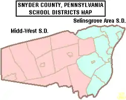
Public school districts
Early child education
According to the Office of Child Development and Early Learning of the Pennsylvania Department of Education June 2007 report, Snyder County is rated low to moderate risk level for children who are “at risk” and therefore might benefit from more taxpayer funded services. Snyder County was rated 1.86 ARL, in the lowest 25% of counties for average risk level.[44]
- Children's Discovery Centers Inc
- Loving Hearts Day Care - Middleburg
- Susquehanna Valley Preschool
- Rock Preschool - Shamokin Dam
- Selinsgrove High School Children's Center
- SUMCD - Susquehanna Children's Center - Selinsgrove
Head Start preschool programs
Head Start is a federally and state funded preschool program for low income children. The program serves 3 and 4 year olds. In order to participate the family income must be below federal poverty guidelines.
- Middleburg Head Start Center[45]
Private schools
As reported by the National Center for Educational Statistics[46]
- Bannerville School, Mcclure, Grades 2-8
- Chapman Parochial School, Port Trevorton, Grades 1-9
- Gospel Christian Academy, Selinsgrove, Grades KG-11
- Jacks Mountain School, Mcclure, Grades 1-8
- Kantz Church School, Middleburg, Grades 1-8
- Lakeview School, Port Trevorton, Grades 1-8
- Leaning Oak School, Mount Pleasant Mills, Grades 1-9
- Locust Grove School, Mount Pleasant Mills, Grades 1-8
- Meadow View School, Trevorton, Grades 1-8
- New Story School, Special education K-12, Selinsgrove Operates in the former Jackson-Penn Elementary School building on lease from SASD[47]
- Palace Creek School, Mount Pleasant Mills, Grades 1-8
- Penn View Christian Academy, Penns Creek, Grades PK-12
- Shady Grove Parochial School, Port Trevorton, Grades 1-8
- White Oak School Liverpool, Grades 1-8
Child abuse cases reported
In 2014, 353 child abuse reports were made to the Snyder Children and Youth Agency. In 2015, reported cases increased to 587 a 66% increase in reports over 2014.[48] The increase in cases was attributed to a new state law specifying more professions are mandated reporters including: teachers, college professors, coaches, advisors of youth organizations and public school employees.[49]
Transportation
Snyder County has two main arteries. U.S. Routes 11/15 travel through the county on the east end generally following the path of the Susquehanna River. The highway is a major travel artery through the region. Flow is constant (truck and vehicle) with very heavy loads and backups on Fridays (especially in the afternoon) and holiday weekends. There is a proposed major highway bypass project called the Central Susquehanna Valley Thruway. It is meeting with funding challenges that have delayed the project for decades. The proposed thruway would cross Monroe Township just north of Shamokin Dam. Many residential properties are designated for eminent domain actions.[50][51] Residents along the proposed route have expressed concerns about the negative impact on their quality of life that the thruway would mean. Others are concerned that the bypass will mean the loss of local revenue and jobs that the traffic brings to the many local restaurants and hotels that are located along the current U.S. 11/15 highway. In June 2007 another two-year delay was announced by the Pennsylvania Department of Transportation.[52] The primary roadblock is a lack of funding for the estimated over $300 million project.[53] U.S. Route 522 begins in Selinsgrove and travels west through Kreamer, Middleburg and on to Lewistown. Route 35 begins on U.S. 11/15 south of Selinsgrove and runs roughly parallel to Route 522 crossing through Freeburg and Mount Pleasant Mills then westward to McAllisterville and Richfield in western Snyder County.
Snyder County is in Pennsylvania Department Of Transportation District 3. According to PennDOT there are 240 state-owned bridges in the county. Currently, many existing bridges and roads in the county are in need of repair.[54][55][56] In 2007, 27 of the bridges were rated structurally deficient and 4 were posted with weight limits. The bridge that spans Middle Creek in Kreamer has been deemed structurally deficient by the state.[57]
State routes 235, 104 and 204 cross the county in a north–south direction.
Communities
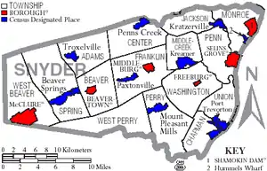
Under Pennsylvania law, there are four types of incorporated municipalities: cities, boroughs, townships, and, in at most two cases, towns. The following boroughs and townships are located in Snyder County:
Boroughs
- Beavertown
- Freeburg
- McClure
- Middleburg (county seat)
- Selinsgrove
- Shamokin Dam
Townships
Census-designated places
Census-designated places are geographical areas designated by the U.S. Census Bureau for the purposes of compiling demographic data. They are not actual jurisdictions under Pennsylvania law. Other unincorporated communities, such as villages, may be listed here as well.
Population ranking
The population ranking of the following table is based on the 2010 census of Snyder County.[19]
† county seat
| Rank | City/Town/etc. | Municipal type | Population (2010 Census) |
|---|---|---|---|
| 1 | Selinsgrove | Borough | 5,654 |
| 2 | Shamokin Dam | Borough | 1,686 |
| 3 | Hummels Wharf | CDP | 1,353 |
| 4 | † Middleburg | Borough | 1,309 |
| 5 | Beavertown | Borough | 965 |
| 6 | McClure | Borough | 941 |
| 7 | Kreamer | CDP | 822 |
| 8 | Port Trevorton | CDP | 769 |
| 9 | Penns Creek | CDP | 715 |
| 10 | Beaver Springs | CDP | 674 |
| 11 | Freeburg | Borough | 575 |
| 12 | Richfield (partially in Juniata County) | CDP | 549 |
| 13 | Mount Pleasant Mills | CDP | 464 |
| 14 | Kratzerville | CDP | 383 |
| 15 | Paxtonville | CDP | 265 |
| 16 | Troxelville | CDP | 221 |
Culture
Snyder County is well known for its unmistakable Pennsylvania German language and culture, agricultural heritage, as well as its fraktur, Kentucky rifles, wood products industries, Middleswarth chip factory, and the annual fairs, festivals, and auctions that keep the local heritage alive. Some of the more famous historical structures of the county are the Governor Snyder Mansion, Pomfret's Castle, Schoch Block House, ruins of the Pennsylvania Canal, and its covered bridges. Snyder County is home to Snyder-Middleswarth State Park, the Tall Timbers Natural Area, and thirteen Pennsylvania state historical markers.
Historical markers
- Pennsylvania Canal (Susquehanna Division) – US 11 & 15 at Port Trevorton
- Simon Snyder – SR 2017 (old US 11 & 15) just S of Selinsgrove
- Simon Snyder Mansion (Plaque) – 121 N. Market St. (old US 11 & 15), Selinsgrove
- Coxey’s Army – 814 N. Market St. (old US 11 & 15), Selinsgrove
- Penns Creek Massacre – SR 2017 (old US 11 & 15) just N of Selinsgrove
- Penns Creek Massacre (Plaque) – S end Old Trail (just E of US 11 & 15), Penns Creek N of Selinsgrove
- Schoch Blockhouse – US 522 at Kreamer
- Susquehanna University – US 522, .5 mile W of old US 11 & 15, Selinsgrove
- Albany Purchase – US 522 (old US 11 & 15) 1 mile N of Selinsgrove
- Harris Ambush (Plaque) – At the Old Bridge, 1/2 mile W of Selinsgrove
- Sunbury – U.S. 11 & 15, 4 miles N of Selinsgrove
- Shikellamy – US 11, 5.4 miles N of Selinsgrove entrance to Shikellamy State Park
- Snyder County – County courthouse, 9 W. Market St. (US 522), Middleburg[59]
References
- "State & County QuickFacts". United States Census Bureau. Archived from the original on July 20, 2011. Retrieved November 22, 2013.
- "Find a County". National Association of Counties. Retrieved June 7, 2011.
- "Historical Society." Snyder County - Default. Web. 27 Oct. 2011. http://www.snydercounty.org/Depts/Historical_Society/Pages/HistoricalSociety.aspx
- "2010 Census Gazetteer Files". United States Census Bureau. August 22, 2012. Retrieved March 10, 2015.
- "Population and Housing Unit Estimates". Retrieved October 9, 2018.
- "U.S. Decennial Census". United States Census Bureau. Retrieved March 10, 2015.
- "Historical Census Browser". University of Virginia Library. Retrieved March 10, 2015.
- Forstall, Richard L., ed. (March 24, 1995). "Population of Counties by Decennial Census: 1900 to 1990". United States Census Bureau. Retrieved March 10, 2015.
- "Census 2000 PHC-T-4. Ranking Tables for Counties: 1990 and 2000" (PDF). United States Census Bureau. April 2, 2001. Retrieved March 10, 2015.
- US Census Bureau (2016). "Snyder County, Pennsylvania Quick Facts 2010".
- Jeff Guo (September 15, 2015). "Lower wages for whites, higher wages for immigrants, and inequality for all". Washington Post.
- "U.S. Census website". United States Census Bureau. Retrieved May 2014. Check date values in:
|access-date=(help) - US Census Bureau (2015). "Poverty Rates by County". Small Area Income and Poverty Estimates.
- Pennsylvania Budget and Policy Center (2012). "Student Poverty Concentration 2012". Archived from the original on 2015-12-22. Retrieved 2018-12-06.
- Emma Ginader, "Union Shows Highest spike in food need," The Daily Item, February 17, 2016
- US Census Bureau, 2014 Community Survey, 2015
- Rick Dandes, "Fewer Kids having Kids," The Daily Item, March 13, 2016
- "Office of Management and Budget". Retrieved 13 June 2018.
- CNMP, US Census Bureau. "This site has been redesigned and relocated. - U.S. Census Bureau". www.census.gov. Retrieved 13 June 2018.
- Leip, David. "Dave Leip's Atlas of U.S. Presidential Elections". uselectionatlas.org. Retrieved June 13, 2018.
- "President Map - Election Results 2008 - The New York Times". elections.nytimes.com. Retrieved 13 June 2018.
- "David Leip's Presidential Election Atlas". Archived from the original on 7 June 2006. Retrieved 13 June 2018.
- "Presidential election of 1912 - Map by counties". geoelections.free.fr. Archived from the original on 13 June 2018. Retrieved 13 June 2018.
- "Presidential Elections". staffweb.wilkes.edu. Retrieved 13 June 2018.
- Snyder County election site
- Moore, Marcia (January 29, 2018). "Judge names Snyder County chief clerk as commissioner". The Daily Item.
- WKOK.com, Snyder Co. Commissioner Derk resigning to work for SU, December 20, 2017
- Marcia Moore., Taxes raised $2M to Balance Budget, The Daily Item, January 1, 2016
- WKOK1070AM.com, The vote is in, no new taxes for Snyder County, December 28, 2017
- Center, Legislativate Data Processing. "Find Your Legislator". The official website for the Pennsylvania General Assembly. Retrieved 2017-05-11.
- Pennsylvania General Assembly (2016). "Snyder County PA Legislators".
- WNEP-TV 6., IconLegacy Story, June 2, 2015
- "Pennsylvania Department of the Auditor General". www.auditorgen.state.pa.us. Retrieved 13 June 2018.
- The Daily Item (Jan 9, 2015). "J.C. Penney closing at Susquehanna Valley Mall".
- Pennsylvania Department of Labor and Industry (December 2013). "County Profiles - Snyder County". Archived from the original on 2015-02-03. Retrieved 2015-02-03.
- Alter, Theodore R. "Strengthening Rural Pennsylvania" Brookings Institution. March 2007. "Archived copy". Archived from the original on 2007-07-11. Retrieved 2007-07-07.CS1 maint: archived copy as title (link)
- Pennsylvania Department of Labor and Industry (February 2016). "County Profiles - Snyder County 2015". Archived from the original on 2015-02-03. Retrieved 2015-02-03.
- WKOK 1070AM, On the Mark March 4, 2016 Bob Garret Greater Susquehanna Valley Chamber of Commerce interview, March 4, 2016
- Bob Garrett (March 2016). "Greater Susquehanna Valley Chamber of Commerce President's Message".
- "Snyder County Profile 2016, PA L&I Center for Workforce Information & Analysis" (PDF). June 2016.
- Legislative Budget and Finance Committee (September 2008). "Review of the Agricultural Conservation Easement Purchase Program" (PDF). Archived from the original (PDF) on 2013-10-07. Retrieved 2014-06-22.
- Legislative Budget and Finance Committee, The Effectiveness of the Agricultural Lands Condemnation Approval Board to Adequately Protect ACE - Restricted Land From Condemnation, September 2008
- Pennsylvania Department of Transportation, Central Susquehanna Valley Transportation Project, S.R. 0015, Section 088, Snyder, Union and Northumberland Counties Environmental Impact Statement Vol I, 2003
- "Pennsylvania Department of Education". www.pde.state.pa.us. Retrieved 13 June 2018.
- Snyder, Union, Mifflin Child Development Report. Feb 2010
- ies, National Center for Education Statistics, U.S. Department of Education, Institute of Education Sciences, Private School Universe Survey 2008
- Ali Stevenes (August 21, 2013). "Ribbon cut on a new school in Selinsgrove". WKOK.com 1070AM.
- John Zaklansky., Increase in referrals, abuse cases. The Daily Item, April 10, 2016
- John Zaklansky., Child Abuse Awareness takes on new meaning. The Daily Item, April 10, 2016
- Honorable Bonnie Brigance Leadbetter, Judge (June 17, 2013). "Eastern Communities Limited: Partnership v. Pennsylvania Department of Transportation" (PDF).
- Pennsylvania Department of Transportation (July 2007). "WHEN YOUR LAND IS NEEDED FOR TRANSPORTATION PURPOSES" (PDF). Archived from the original (PDF) on 2011-08-14. Retrieved 2014-06-22.
- Lynda Schlegel-Culver, Governor Rendell Robs Thruway Project to Fund Transit, Say Schlegel-Culver, Keller, December 3, 2010
- Amanda Alexander (July 2010). "CSVT funding still in question". Standard Journal.
- PennDOT report on Snyder County roads and bridges in need of repair Archived 2007-09-28 at the Wayback Machine
- Gessel, Damian, "State of Bridges", The Daily Item, August 5, 2007
- Levy, Marc, "Long road ahead", The Daily Item, August 5, 2007
- Gessel, Damian, "State of Valley Bridges", The Daily Item. August 5, 2007.
- "Kissimmee PA". Place Beam.
- "Historical Society". www.snydercounty.org. Retrieved 13 June 2018.
External links
| Wikivoyage has a travel guide for Snyder County. |
- Snyder County
- Pennsylvania Department of Transportation, Bureau of Planning and Research, Geographic Information Division, "2005 General Highway Map of Union and Snyder Counties". Note: shows boroughs, townships, roads, villages, some streams. URL accessed on April 5, 2006.
- Hazardous Air Pollutant Report
- Central Susquehanna Valley Thruway
- Public Hunting Map. Snyder County
- Governor's Center for Local Government Services
Municipalities and communities of Snyder County, Pennsylvania, United States | ||
|---|---|---|
| Boroughs | | |
| Townships | ||
| Census-designated places | ||
| Unincorporated communities | ||
| Footnotes | ‡This populated place also has portions in an adjacent county or counties | |
| ||

| Authority control |
|---|