Norwood, Colorado
Norwood is a Statutory Town in San Miguel County, Colorado, United States. The population was 518 at the 2010 census.
Town of Norwood, Colorado | |
|---|---|
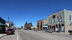 Grand Avenue, Norwood's main street | |
 Location of Norwood in San Miguel County, Colorado. | |
| Coordinates: 38°7′52″N 108°17′29″W | |
| Country | |
| State | |
| County[1] | San Miguel |
| Incorporated (town) | August 20, 1903[2] |
| Government | |
| • Type | Statutory Town[1] |
| Area | |
| • Total | 0.28 sq mi (0.73 km2) |
| • Land | 0.28 sq mi (0.73 km2) |
| • Water | 0.00 sq mi (0.00 km2) |
| Elevation | 7,011 ft (2,137 m) |
| Population (2010) | |
| • Total | 518 |
| • Estimate (2019)[5] | 579 |
| • Density | 2,045.94/sq mi (790.19/km2) |
| Time zone | UTC-7 (Mountain (MST)) |
| • Summer (DST) | UTC-6 (MDT) |
| ZIP code[6] | 81423 (PO Box) |
| Area code(s) | 970 |
| FIPS code | 08-54880 |
| GNIS feature ID | 0186059 |
| Website | www |
A post office called Norwood has been in operation since 1887.[7] The community was named after Norwood, Missouri, the native home of a first settler.[8]
Geography
Norwood is located at 38°7′52″N 108°17′29″W (38.131077, -108.291478).[9]
According to the United States Census Bureau, the town has a total area of 0.3 square miles (0.78 km2), all land.
Demographics
| Historical population | |||
|---|---|---|---|
| Census | Pop. | %± | |
| 1910 | 212 | — | |
| 1920 | 365 | 72.2% | |
| 1930 | 299 | −18.1% | |
| 1940 | 412 | 37.8% | |
| 1950 | 294 | −28.6% | |
| 1960 | 443 | 50.7% | |
| 1970 | 408 | −7.9% | |
| 1980 | 478 | 17.2% | |
| 1990 | 429 | −10.3% | |
| 2000 | 438 | 2.1% | |
| 2010 | 518 | 18.3% | |
| 2019 (est.) | 579 | [5] | 11.8% |
| U.S. Decennial Census[10] | |||
As of the census[11] of 2000, there were 438 people, 195 households, and 112 families residing in the town. The population density was 1,709.7 people per square mile (650.4/km2). There were 258 housing units at an average density of 1,007.1 per square mile (383.1/km2). The racial makeup of the town was 97.49% White, 1.60% Native American, 0.23% from other races, and 0.68% from two or more races. Hispanic or Latino of any race were 5.48% of the population.
There were 195 households, out of which 27.2% had children under the age of 18 living with them, 45.6% were married couples living together, 6.7% had a female householder with no husband present, and 42.1% were non-families. 35.4% of all households were made up of individuals, and 7.7% had someone living alone who was 65 years of age or older. The average household size was 2.25 and the average family size was 2.92.
In the town, the population was spread out, with 24.4% under the age of 18, 10.0% from 18 to 24, 32.0% from 25 to 44, 25.3% from 45 to 64, and 8.2% who were 65 years of age or older. The median age was 38 years. For every 100 females, there were 105.6 males. For every 100 females age 18 and over, there were 95.9 males.
The median income for a household in the town was $39,375, and the median income for a family was $50,313. Males had a median income of $33,750 versus $22,813 for females. The per capita income for the town was $19,687. None of the families and 5.6% of the population were living below the poverty line, including no under eighteens and 20.6% of those over 64.
Notable people
- Robert B. Duffield (1917-2000), radiochemist who headed the Argonne National Laboratory.[12]
See also
- Outline of Colorado
- State of Colorado
- Colorado cities and towns
- Colorado municipalities
- Colorado counties
- Colorado cities and towns
- San Juan Mountains
References
- "Active Colorado Municipalities". State of Colorado, Department of Local Affairs. Archived from the original on 2009-12-12. Retrieved 2007-09-01.
- "Colorado Municipal Incorporations". State of Colorado, Department of Personnel & Administration, Colorado State Archives. 2004-12-01. Retrieved 2007-09-02.
- "2019 U.S. Gazetteer Files". United States Census Bureau. Retrieved July 1, 2020.
- "US Board on Geographic Names". United States Geological Survey. 2007-10-25. Retrieved 2008-01-31.
- "Population and Housing Unit Estimates". United States Census Bureau. May 24, 2020. Retrieved May 27, 2020.
- "ZIP Code Lookup". United States Postal Service. Archived from the original (JavaScript/HTML) on September 3, 2007. Retrieved November 26, 2007.
- "Post offices". Jim Forte Postal History. Retrieved 1 July 2016.
- Dawson, John Frank. Place names in Colorado: why 700 communities were so named, 150 of Spanish or Indian origin. Denver, CO: The J. Frank Dawson Publishing Co. p. 37.
- "US Gazetteer files: 2010, 2000, and 1990". United States Census Bureau. 2011-02-12. Retrieved 2011-04-23.
- "Census of Population and Housing". Census.gov. Retrieved June 4, 2015.
- "U.S. Census website". United States Census Bureau. Retrieved 2008-01-31.
- "Robert B. Duffield ’40",Princeton Alumni Weekly. Accessed August 31, 2020. "Bob died at his home in Norwood, Colo., on Dec. 26, 2000, after a brief illness with acute leukemia. He prepared at Asbury Park H.S."
External links
- Town of Norwood website
- Norwood Chamber of Commerce
- CDOT map of the Town of Norwood
- Norwood Post Newspaper
- The Watch Newspaper
Municipalities and communities of San Miguel County, Colorado, United States | ||
|---|---|---|
| Towns | 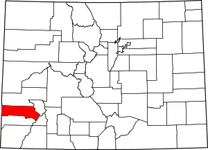 Map of Colorado highlighting San Miguel County | |
| CDP | ||
| Unincorporated communities | ||
| Ghost town | ||
| ||
