Ranong Province
Ranong (Thai: ระนอง [rá.nɔ̄ːŋ]) is one of Thailand's southern provinces (changwat), on the west coast along the Andaman Sea. It has the fewest inhabitants of all Thai provinces. Provinces neighboring Ranong are (clockwise) Chumphon, Surat Thani, and Phang Nga. To the west, it borders Kawthaung, Tanintharyi, Myanmar.
Ranong
ระนอง | |
|---|---|
_%E0%B8%A3%E0%B8%B0%E0%B8%99%E0%B8%AD%E0%B8%87.jpg.webp) Suwannakhiri temple | |
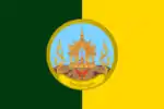 Flag 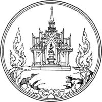 Seal | |
 Map of Thailand highlighting Ranong Province | |
| Country | Thailand |
| Capital | Ranong |
| Government | |
| • Governor | Chatuphot Piyamputra (since October 2016) |
| Area | |
| • Total | 3,298 km2 (1,273 sq mi) |
| Area rank | Ranked 59th |
| Population (2018)[2] | |
| • Total | 191,868 |
| • Rank | Ranked 77th |
| • Density | 58/km2 (150/sq mi) |
| • Density rank | Ranked 70th |
| Human Achievement Index | |
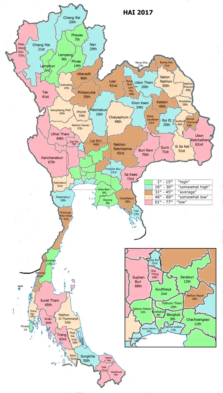
| • HAI (2017) | 0.5937 "average" Ranked 32nd |
| Time zone | UTC+7 (ICT) |
| Postal code | 85xxx |
| Calling code | 077 |
| ISO 3166 code | TH-85 |
| Website | www |
Geography
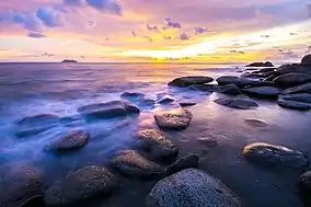
Ranong is on the Kra Isthmus, a narrow strip of land, only 44 kilometres (27 mi) wide,[4] that connects Thailand with the Malay Peninsula, on the west of the Phuket mountain range. It has a long coast on the Andaman Sea. The province, together with Trat Province, is known for being one of the wettest places in Thailand, the rainy season lasting for about eight months.[5]
Ranong is the least populated province. Eighty percent of its area is covered by forests, and 67 percent is mountainous. In former years the major industry was tin mining, but most mines are now exhausted. White clay mining (for the production of porcelain) and fishing are now the main industries, along with rubber and cashew nuts.
The Ngao Mangrove Forest Research Centre, also known as the Ranong Biosphere Reserve, in the north of Kapoe District, covering 189,431 rai[4] (303.09 km2), was declared in 1997. It is the fourth biosphere reserve of Thailand, and the only one on the seacoast protecting mangrove forests. Khlong Nakha Wildlife Sanctuary is in the south of the province.
History
Ranong province once was a deputy town of Chumphon in the Ayutthaya era (1350–1767).[6] It was a small, mountainous town that protected Chumphon from Burma. The population was very low until the discovery of tin, when people from many cities and foreigners started to visit Ranong to do tin business there. This also gave rise to the name Ranong, which was a distorted form of rae nong (แร่นอง), meaning "full of minerals".[7] The ruler of Ranong was known after the town as Luang Ranong (Thai: หลวงระนอง)
At the start of the Rattanakosin era (1781–present), there was a wealthy Chinese merchant named Kho Su Jiang who bought all the tin business in Ranong and was appointed tax collector of Ranong, with the title Luang Rattana Setti (Thai: หลวงรัตนเศรษฐี), by King Nangklao (Rama III). In 1854, the Luang Ranong died. King Mongkut (Rama IV) then promoted Kho Su Jiang to the position, promoting him to Phra Rattana Setti (Thai: พระรัตนเศรษฐี). By then, Ranong's wealth had increased greatly and through taxation was a significant source of income for the capital, thus in 1877 King Chulalongkorn (Rama V) elevated Ranong to provincial status, answering directly to Bangkok as opposed to Chumphon, with Phra Rattana Setti becoming its first governor.[6]
After the First Anglo-Burmese War, when the British assumed control of Tenasserim and the Kraburi River became the demarcation line between Siam and British-controlled Burma, Rayong became an important border city where goods were exchanged, a status which extends past the independence of Burma to the present.
Being located on the Kra Isthmus, the narrowest part (44 kilometres) of the Malay Peninsula, the idea of a canal through the area has been long suggested, particularly by the French. If successful, traveling from Europe to China would be easier because one would pass through Thailand, which was faster and cheaper, instead of circumnavigating Malaysia. This was seen as a threat to the financial growth of the harbors of Singapore and Penang, which at the time were owned by Britain, who therefore forced the suspension of the project. At the end of World War II, Thailand signed a British-imposed treaty called "The Termination of The State of War Between Siam and Allies", which forbade Thailand from digging such a canal without British permission. This treaty was revoked in 1954.[8] Since then, plans for the canal have continued to be suggested and discussed, even in the present day, though prime minister Prayut Chan-o-cha said in 2018 that it was not a government priority.[9]
Ranong has also been historically significant as a residence for royal tours of the southern provinces, with many kings of Thailand visiting Ranong in the past. The first was King Chulalongkorn, who stayed at Rattana Ransan palace for three nights in 1890. The palace is now a landmark in Ranong. King Prajadhipok (Rama VII) visited in 1928, and King Bhumibol (Rama IX) and Queen Sirikit visited in 1959.
Climate
Most of Thailand receives from 1,200 to 1,600 mm of precipitation per year. Two provinces, Ranong and Trat, receive more than 4,500 mm a year making them the wettest places in the country.[10]
Symbols
The provincial seal shows a castle on top of a hill, as an aide memoire that King Chulalongkorn (Rama V) once visited Ranong and stayed at the Ratana Rangsan Castle on top of the Niveskiri Hill. The number five refers to King Rama V; the castle is Ratana Rangsan Palace; the mountain is Niveshkiri; the royal tray refers to the people of Ranong.[11]
The provincial slogan is, "Kra Isthmus, mountain grass, cashew nut, mineral water stream, and real pearl of Ranong."[11]
The provincial tree is the Banaba (Lagerstroemia speciosa), and the provincial flower is the orchid Dendrobium formosum.
Administrative divisions
Provincial government
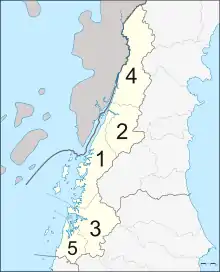
Ranong is divided into five districts (amphoe). These are further divided into 30 subdistricts (tambon) and 167 villages (muban).
| 1 | Mueang Ranong | เมืองระนอง |
| 2 | La-un | ละอุ่น |
| 3 | Kapoe | กะเปอร์ |
| 4 | Kra Buri | กระบุรี |
| 5 | Suk Samran | สุขสำราญ |
Local government
As of 26 November 2019 there are:[12] one Ranong Provincial Administration Organisation (ongkan borihan suan changwat) and 12 municipal (thesaban) areas in the province. Ranong and Bang Rin have town (thesaban mueang) status. Further 10 subdistrict municipalities (thesaban tambon). The non-municipal areas are administered by 18 Subdistrict Administrative Organisations - SAO (ongkan borihan suan tambon).[2]
Transportation
Phet Kasem Road (Thailand Route 4) runs through the city. Ranong Airport is about 24 kilometres (15 mi) south of town.
The Port Authority of Thailand operates the Ranong Port, which is Thailand's principal Indian Ocean port. In 2008, the Ranong human-smuggling incident resulted in 54 deaths.[13]
Human achievement index 2017
| Health | Education | Employment | Income |
| 1 | 65 | 7 | 41 |
| Housing | Family | Transport | Participation |
 |
 |
||
| 54 | 45 | 45 | 60 |
| Province Ranong, with an HAI 2017 value of 0.5937 is "average", occupies place 32 in the ranking. | |||
Since 2003, United Nations Development Programme (UNDP) in Thailand has tracked progress on human development at sub-national level using the Human achievement index (HAI), a composite index covering all the eight key areas of human development. National Economic and Social Development Board (NESDB) has taken over this task since 2017.[3]
| Rank | Classification |
| 1 - 15 | "high" |
| 16 - 30 | "somewhat high" |
| 31 - 45 | "average" |
| 45 - 60 | "somewhat low" |
| 61 - 77 | "low" |
| Map with provinces and HAI 2017 rankings |
 |
Tourism
Namtok Ngao National Park (อุทยานแห่งชาติน้ำตกหงาว) Covering a total area of approximately 417,500 rai (668 km2) it was declared a national park on 3 June 1999.[14]
Ko Chang (Ranong) (เกาะช้าง) island in tambon Ko Phayam. With an area of 18 square kilometres and 80 homes on the entire island. Cashew and para rubber plantations as well as coastal fisheries are the main industries.[15]
Laem Son National Park (อุทยานแห่งชาติแหลมสน) It covers a total area of 196,875 rai (31.5 hectares). It also includes islands in the Andaman Sea; namely, Ko Khangkhao and Mu Ko Kam.[16] Places of interest within the national park include:
- Hat Bang Ben (หาดบางเบน) is a long sandy beach shaded by pine trees where the national park headquarters is located.
- Hat Laem Son (หาดแหลมสน) is a white sandy beach approximately four kilometres next to Hat Bang Ben.
- Hat Praphat or Hat Hin Thung (หาดประพาส หรือ หาดหินทุ่ง) Similar to Hat Bang Ben, Hat Praphat is a large beach shaded by pine trees.
- Ko Khangkhao (เกาะค้างคาว) is an island with fine sandy beaches and a gravel beach known as Hat Hin Ngam in the north.
- Ko Kam Yai (เกาะกำใหญ่) is a scenic island with white sandy beaches.
- Ko Kam Nui (เกาะกำนุ้ย) is not far from Ko Kam Yai with beaches on one side and many other nearby islets.
 Laem Son National Park
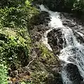 Namtok Chum Saeng, Kra Buri District
 Namtok Punyaban, Mueang Ranong District
 Ko Phayam
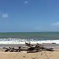 Kamphuan, Suk Samran District
Notes
Reports (data) from Thai government are "not copyrightable" (Public Domain), Copyright Act 2537 (1994), section 7.
References
- Advancing Human Development through the ASEAN Community, Thailand Human Development Report 2014, table 0:Basic Data (PDF) (Report). United Nations Development Programme (UNDP) Thailand. pp. 134–135. ISBN 978-974-680-368-7. Retrieved 17 January 2016, Data has been supplied by Land Development Department, Ministry of Agriculture and Cooperatives, at Wayback Machine.
- "รายงานสถิติจำนวนประชากรและบ้านประจำปี พ.ศ.2561" [Statistics, population and house statistics for the year 2018]. Registration Office Department of the Interior, Ministry of the Interior (in Thai). 31 December 2018. Retrieved 20 June 2019.
- Human achievement index 2017 by National Economic and Social Development Board (NESDB), pages 1-40, maps 1-9, retrieved 14 September 2019, ISBN 978-974-9769-33-1
- Svasti, Pichaya (19 July 2018). "Another Pearl of the Andaman". Bangkok Post. Retrieved 19 July 2018.
- "Ranong". Tourism Authority of Thailand (TAT). Retrieved 26 May 2015.
- Ministry of Culture (26 March 2017). "พัฒนาการทางประวัติศาสตร์ระนอง". Retrieved 20 August 2019.
- Provincial Community Development Office of Ranong (4 October 2016). "ประวัติความเป็นมา". Retrieved 20 August 2019.
- "Proposed Thai canal project: Between myth and reality". Malay Mail. 28 June 2013. Retrieved 20 August 2019.
- "Proposed Kra Canal not priority project for Thai govt". The Straits Times. 13 February 2018. Retrieved 20 August 2019.
- "The Climate of Thailand" (PDF). Thai Meteorological Department (TMD). p. 4. Retrieved 21 June 2019.
- "Symbol of Ranong". OSM Andamnan: The Office of Strategy Management for Southern Province Cluster. Retrieved 26 May 2015.
- "Number of local government organizations by province". dla.go.th. Department of Local Administration (DLA). 26 November 2019. Retrieved 10 December 2019.
48 Ranong: 1 PAO, 2 Town mun., 10 Subdistrict mun., 18 SAO.
- "54 Burmese dead in trafficking horror". Phuket Gazette. April 10, 2008. Archived from the original on January 12, 2013. Retrieved September 29, 2018.
- "Namtok Ngao National Park". Department of National Parks (DNP) Thailand. Archived from the original on 26 May 2015. Retrieved 26 May 2015.
- "Koh Chang". Tourism Authority of Thailand (TAT). Retrieved 19 July 2018.
- "Laemson National Park". Department of National Parks (DNP) Thailand. Retrieved 26 May 2015.
External links
 Ranong travel guide from Wikivoyage
- Official website
- Ranong provincial map, coat of arms and postal stamp
| Wikimedia Commons has media related to Ranong Province. |
Places adjacent to Ranong Province | |
|---|---|
| Authority control |
|---|