Suphan Buri Province
Suphan Buri (Thai: สุพรรณบุรี, pronounced [sù.pʰān būrīː]) located in the central region of Thailand, is one of the country's 76 provinces (จังหวัด, changwat), the first-level administrative divisions. Neighbouring provinces are (from north clockwise) Uthai Thani, Chai Nat, Sing Buri, Ang Thong, Phra Nakhon Si Ayutthaya, Nakhon Pathom and Kanchanaburi. As of 2018 the province counted a population of around 848,700, representing about 1.28% of the country's population.[4]
Suphan Buri
สุพรรณบุรี | |
|---|---|
 .jpg.webp) 2.jpg.webp) _02.jpg.webp)  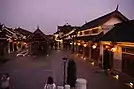 (clockwise from top left) Don Chedi Memorial, Wat Pa Lelai Worawihan, Buddhist heaven and hell park at Wat Phai Rong Wua, Chinese village replica at the Dragon Descendants Museum, Phu Toei National Park, Giant Dragon Statue of Dragon Descendants Museum near the Suphan Buri Tutelary Shrine | |
 Flag 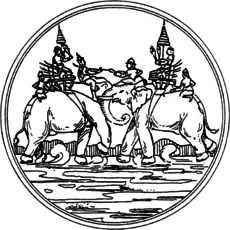 Seal | |
| Nickname(s): Suphan | |
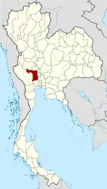 Map of Thailand highlighting Suphan Buri Province | |
| Country | Thailand |
| Capital | Suphan Buri |
| Government | |
| • Governor | Nimit Wanchaithanawong (since October 2017) |
| Area | |
| • Total | 5,358 km2 (2,069 sq mi) |
| Area rank | Ranked 39th |
| Population (2018)[2] | |
| • Total | 848,720 |
| • Rank | Ranked 29th |
| • Density | 158/km2 (410/sq mi) |
| • Density rank | Ranked 24th |
| Human Achievement Index | |
| • HAI (2017) | 0.5403 "low" Ranked 68th |
| Time zone | UTC+7 (ICT) |
| Postal code | 72xxx |
| Calling code | 035 |
| ISO 3166 code | TH-72 |
| Website | www |
Toponymy
The word suphan originates from the Sanskrit word Suvarna (Devanagari: सुवर्ण), meaning 'gold', and the word buri from Sanskrit purī (Devanagari: पुरी), meaning 'town' or 'city'. Hence the name of the province literally means 'city of gold'.
Geography
The terrain of the province is mostly low river plains, with small mountain ranges in the north and the west of the province. The southeastern part with the very low plain of the Tha Chin River is paddy rice farming area.
History
Suphan Buri might be the site of the legendary Suvarnabhumi, which is mentioned in very old Buddhist writings.[5] However the first confirmed historical settlement was in the Dvaravati period, when the city was known as Meuang Thawarawadi Si Suphannaphumi ('the Dvaravati city of Suvarnabhumi').[6] Its founding took place c. 877-882. Later it was called U Thong, and was the home city of Prince U Thong, the founder of the Ayutthaya Kingdom. King Khun Luang Pha Ngua gave it the current name. Suphan Buri was a border city, and the site of several battles with the neighbouring Burmese.
Economy
The province is Thailand's largest producer of water chestnuts (Thai: ลูกแห้ว, RTGS: luk haeo), grown mainly in Mueang Suphan Buri, Sam Chuk, and the Si Prachan Districts of the province. About half of the province's 3,000 rai of cultivated water chestnuts are found in Tambon Wang Yang of Si Prachan. The vegetable was registered as a geographical indication (GI) product of Suphan Buri in 2017.[7] The Thai dessert thapthim krop (Thai: ทับทิมกรอบ), with water chestnuts as its main ingredient, was named one of the world's best 50 desserts in 2019 by CNN Travel.[8]
Symbols
The provincial seal shows the elephant battle between King Naresuan the Great and the crown prince of Burma in 1592, which took place in Suphan Buri.
The provincial tree is the ebony tree (Diospyros mollis), มะเกลือ.
Administrative divisions

Provincial government
The province is divided into 10 districts (amphoes). The districts are further divided into 110 subdistricts (tambons) and 977 villages (mubans).
Local government
As of 26 November 2019 there are:[9] one Suphan Buri Provincial Administration Organisation (ongkan borihan suan changwat) and 45 municipal (thesaban) areas in the province. Suphan Buri and Song Phi Nong have town (thesaban mueang) status. Further 43 subdistrict municipalities (thesaban tambon). The non-municipal areas are administered by 81 Subdistrict Administrative Organisations - SAO (ongkan borihan suan tambon).[2]
Health
Suphan Buri's main hospital is Chao Phraya Yommarat Hospital, operated by the Ministry of Public Health.
Transportation

Rail
Suphan Buri is at the end of a 157 kilometres (98 mi) branch line of the State Railway of Thailand's Southern Line, officially terminating at Suphan Buri Railway Station. The branch meets the main line at Nong Pladuk Junction near Ban Pong.
Roads
Route 340 passes through Suphan Buri, leading north to Chai Nat and south to Bang Bua Thong. Route 321 leads west and then south to Nakhon Pathom. Route 329 leads east to Bang Pahan. Route 3195 leads north-east to Ang Thong.
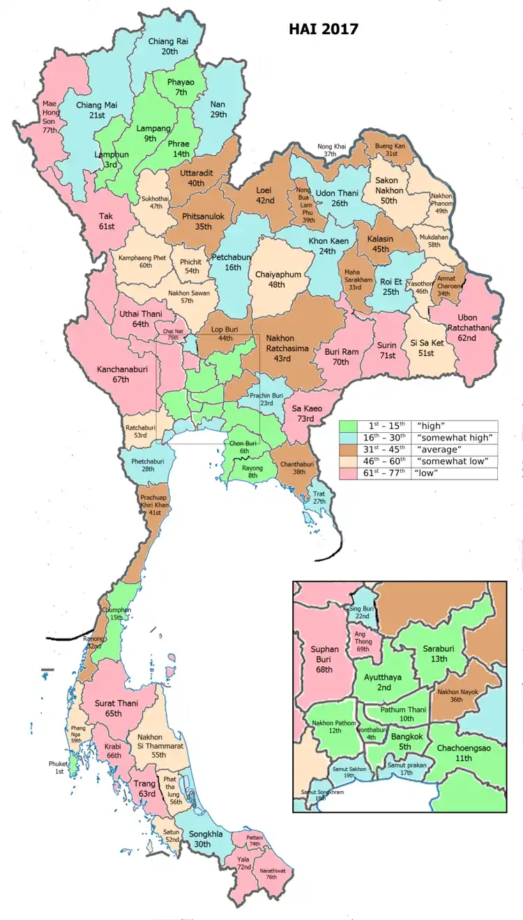
Human achievement index 2017
| Health | Education | Employment | Income |
| 46 | 35 | 51 | 27 |
| Housing | Family | Transport | Participation |
 |
 |
||
| 19 | 77 | 68 | 53 |
| Province 72e Hong Son, with an HAI 2017 value of 0.5403 is "low", occupies place 68 in the ranking. | |||
Since 2003, United Nations Development Programme (UNDP) in Thailand has tracked progress on human development at sub-national level using the Human achievement index (HAI), a composite index covering all the eight key areas of human development. National Economic and Social Development Board (NESDB) has taken over this task since 2017.[3]
| Rank | Classification |
| 1 - 15 | "high" |
| 16 - 30 | "somewhat high" |
| 31 - 45 | "average" |
| 45 - 60 | "somewhat low" |
| 61 - 77 | "low" |
| Map with provinces and HAI 2017 rankings |
 |
Notes
Reports (data) from Thai government are "not copyrightable" (Public Domain), Copyright Act 2537 (1994), section 7.
References
- Advancing Human Development through the ASEAN Community, Thailand Human Development Report 2014, table 0:Basic Data (PDF) (Report). United Nations Development Programme (UNDP) Thailand. pp. 134–135. ISBN 978-974-680-368-7. Retrieved 17 January 2016, Data has been supplied by Land Development Department, Ministry of Agriculture and Cooperatives, at Wayback Machine.
- "รายงานสถิติจำนวนประชากรและบ้านประจำปี พ.ศ.2561" [Statistics, population and house statistics for the year 2018]. Registration Office Department of the Interior, Ministry of the Interior (in Thai). 31 December 2018. Retrieved 20 June 2019.
- Human achievement index 2017 by National Economic and Social Development Board (NESDB), pages 1-40, maps 1-9, retrieved 14 September 2019, ISBN 978-974-9769-33-1
- "Population of the entire kingdom, following the evidence from the population registration on the 31st of December 2019" (PDF). Royal Thai Government Gazette. 30 January 2020. Retrieved 12 June 2020.
- The Siam Society: Miscellaneous Articles Written for the JSS by His Late Highness Prince Damrong. The Siam Society, Bangkok, B.E. 2505 (1962). William J. Gedney, "A Possible Early Thai Route to the Sea", Journal of the Siam Society, Volume 76, 1988, pp.12-16.
- Manit Vallibhotama, "Muang U-Thong", Muang Boran Journal, Volume 14, no.1, January–March 1988, pp.29-44. Warunee Osatharom, Muang Suphan Through Changing Periods, Bangkok, Thammasat University Press, 2004).
- Karnjanatawe, Karnjana (28 May 2020). "Step into the mud". Bangkok Post. Retrieved 28 May 2020.
- Smith, Jen Rose (4 June 2019). "50 of the world's best desserts". CNN Travel. Retrieved 28 May 2020.
- "Number of local government organizations by province". dla.go.th. Department of Local Administration (DLA). 26 November 2019. Retrieved 10 December 2019.
64 Suphan Buri: 1 PAO, 2 Town mun., 43 Subdistrict mun., 81 SAO.
External links
 Suphanburi travel guide from Wikivoyage
- Province page from the Tourist Authority of Thailand
- Suphanburi provincial map, coat of arms and postal stamp
- Suphanburi New Build. The new twelve lakes
Places adjacent to Suphan Buri Province | |
|---|---|
| Wikimedia Commons has media related to Suphanburi Province. |
| Authority control |
|---|