Bueng Kan Province
Bueng Kan (Thai: บึงกาฬ, RTGS: Bueng Kan, pronounced [bɯ̄ŋ kāːn]), also spelled Bung Kan,[6] is the 76th province (changwat) of Thailand, established by the Act Establishing Changwat Bueng Kan, BE 2554 (2011) on 23 March 2011.[7] The province, consisting of the districts (amphoe) partitioned off Nong Khai Province, lies in upper northeastern Thailand also called Isan (Thai: อีสาน). It is named after its central district, Mueang Bueng Kan.
Bueng Kan
บึงกาฬ | |
|---|---|
 Cliff side, Phu Thok | |
 Flag 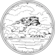 Seal | |
| Motto(s): "ภูทอกแหล่งพระธรรม ค่าล้ำยางพารา งามตาแก่งอาฮง บึงโขงหลงเพลินใจ น้ำตกใสเจ็ดสี ประเพณีแข่งเรือ เหนือสุดแดนอีสาน นมัสการหลวงพ่อใหญ่ ศูนย์รวมใจศาลสองนาง" ("Phu Thok, the source of dharma, Value of rubber, Kaeng Ah Hong beautiful, Bueng Khong Long fascinated, Clear seven color waterfall, Boat race traditions, Northernmost northeast region, Worship Luang Pho Yai and Two Nang Court Shrine") | |
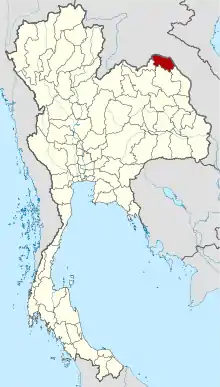 Map of Thailand highlighting Bueng Kan Province | |
| Country | Thailand |
| Created | 23 March 2011 |
| Capital | Bueng Kan |
| Government | |
| • Governor | Sanit Khao-ard (since October 2019)[1] |
| Area | |
| • Total | 4,306 km2 (1,663 sq mi) |
| Area rank | Ranked 52nd |
| Population (2019)[3] | |
| • Total | 424,091 |
| • Rank | Ranked 62nd |
| • Density | 99/km2 (260/sq mi) |
| • Density rank | Ranked 50th |
| Human Achievement Index | |
| • HAI (2017) | 0.5942 "average" Ranked 31st |
| Time zone | UTC+7 (ICT) |
| Postal code | 38xxx |
| Calling code | 042 |
| ISO 3166 code | TH-38 |
| Website | www |
| Bueng Kan Province area[5] | |
Geography
The province is in the northeastern corner of Thailand. It borders, from the south clockwise, Nakhon Phanom, Sakon Nakhon, and Nong Khai Province. To the north and east it borders Bolikhamsai Province of Laos, with the Mekong River forming the boundary.
In Bung Khla district is the Phu Wua Wildlife Sanctuary, protecting forest-covered hills close to the Mekong River.
History
In 1994, Sumet Phromphanhao, a member of the House of Representatives from Nong Khai Province, proposed that the province of Bueng Kan be established by consolidating the Bueng Kan, Seka, So Phisai, Bung Khla, Bueng Khong Long, Pak Khat, Phon Charoen, and Si Wilai Districts of Nong Khai Province as a new province. The new province, if created, would be 4,305 km2,[8] with a population of about 390,000 inhabitants.[9] At that time, the Ministry of Interior replied that creating a new province would load a heavy burden to the state budget and was contrary to the resolution of the Council of Ministers.[10]
The proposal to create Bueng Kan Province was tabled for about 20 years, until 2010 when the Ministry of Interior renewed the project and made a proposal to the Council of Ministers to have a "Bill Establishing Changwat Bueng Kan, BE..." (Thai: ร่างพระราชบัญญัติจัดตั้งจังหวัดบึงกาฬ พ.ศ....) considered.[9] In a poll at the time, 99 percent of the inhabitants of Nong Khai Province supported the proposal.[9] On 3 August 2010, the Council of Ministers resolved to present the bill to the National Assembly,[11][12] citing that the proposal met its criteria for approval.[13]
On 7 February 2011, the National Assembly approved the bill.[14] Prime Minister Abhisit Vejjajiva presented it to King Bhumibol Adulyadej for royal assent. Bhumibol Adulyadej signed the bill on 11 March 2011, enacting it as the "Act Establishing Changwat Bueng Kan, BE 2554 (2011)" (Thai: พระราชบัญญัติตั้งจังหวัดบึงกาฬ พ.ศ. 2554). The act was published in the Government Gazette on 22 March 2011 and came into force the next day.[7]
Economy
Bidding on the construction of the Fifth Thai–Lao Friendship Bridge project is scheduled for July 2020. Construction of the bridge is expected to get started later this year and to be finished by 2023. The project will link Bueng Kan Province with Laos' Bolikhamsai Province across the Mekong River. Its cost will be 1.26 billion baht (US$40.88 million). Thailand has agreed to pay 787 million baht (US$ 25.47 million) and Laos to cover 476 million baht (US$15.41 million). Already existing Thai-Lao Friendship Bridges link Nong Khai Province with Vientiane Prefecture (First Thai–Lao Friendship Bridge); Mukdahan with Savannakhet (Second Thai–Lao Friendship Bridge); Nakhon Phanom with Thakhek (Third Thai–Lao Friendship Bridge); and Chiang Rai Province with Houayxay (Fourth Thai–Lao Friendship Bridge).[15]
Provincial seal
The provincial seal of Bueng Kan, Thailand's 76th and newest province, has a depiction of Phu Thok, a mountain in Si Wilai District, an Isan language name which means 'lonely mountain'.[16]
The provincial flower and tree is Bauhinia sirindhorniae K. and S.S. Larsen.
Climate
Bueng Kan’s climate consists of a wet season and a dry season (between December and January). The temperature decreases during November and is at its lowest in December and January. The temperature quickly increases in March, and peaks in April.[17]
Administrative divisions
Provincial government
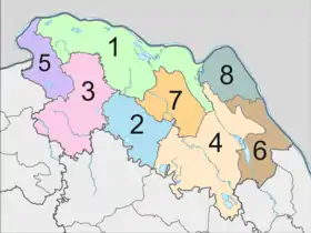
The province is divided into eight districts (amphoe). The districts are further divided into 53 subdistricts (tambon) and 615 villages (muban).
Local government
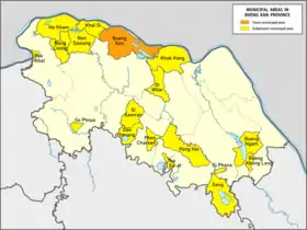
As of 5 August 2020 there are: one Bueng Kan Provincial Administrative Organization - PAO (ongkan borihan suan changwat) and eight-teen municipal (thesaban) areas in the province. The capital Bueng Kan has town (thesaban mueang) status and seventeen subdistrict municipalities (thesaban tambon).[3]
| Town municipality | people | ||
| 1 | Bueng Kan[18] | 19,612 |
| Subdistrict mun. | people | 9 | Non Sawang | 6,920 | |
| 1 | Si Wilai | 11,120 | 10 | Tha Sa-at | 6,886 |
| 2 | Pong Hai | 10,502 | 11 | Pak Khat | 6,854 |
| 3 | Phon Charoen | 10,357 | 12 | So Phisai[19] | 6,728 |
| 4 | Bueng Khong Long | 9,811 | 13 | Si Phana | 6,678 |
| 5 | Sang[20] | 8,875 | 14 | Bueng Ngam[21] | 5,670 |
| 6 | Nong Loeng[22] | 8,725 | 15 | Khai Si[23] | 5,478 |
| 7 | Ho Kham | 7,260 | 16 | Don Yanang | 5,156 |
| 8 | Khok Kong[24] | 7,063 | 17 | Si Samran | 4,970 |
The non-municipal areas are administered by 39 Subdistrict Administrative
Organizations (SAO) (ongkan borihan suan tambon).[25]
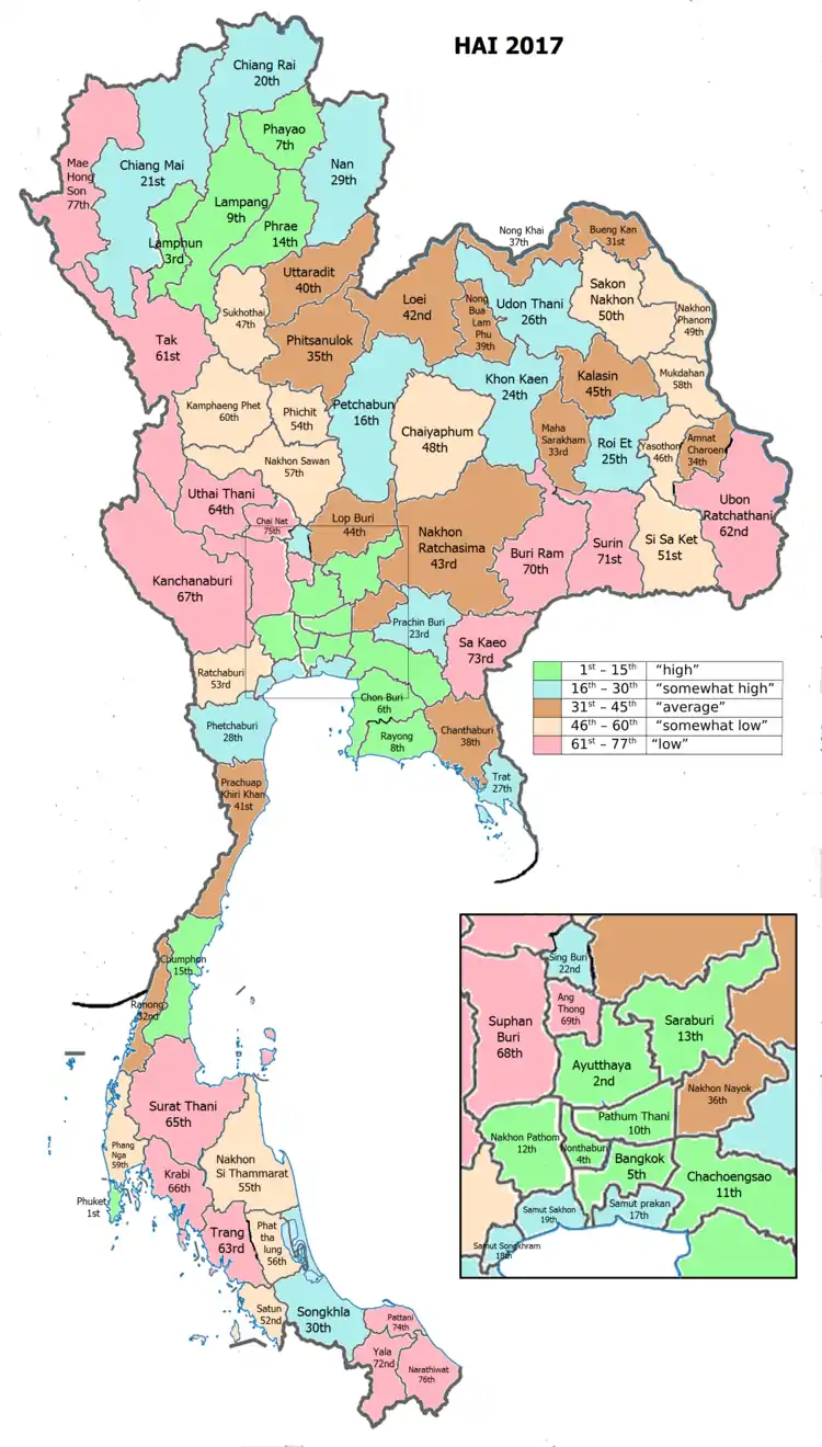
Human achievement index 2017
| Health | Education | Employment | Income |
| 2 | 71 | 61 | 61 |
| Housing | Family | Transport | Participation |
 |
 |
||
| 5 | 6 | 57 | 38 |
| Province Bueng Kan, with an HAI 2017 value of 0.5942 is "average", occupies place 31 in the ranking. | |||
Since 2003, United Nations Development Programme (UNDP) in Thailand has tracked progress on human development at sub-national level using the Human achievement index (HAI), a composite index covering all the eight key areas of human development. National Economic and Social Development Board (NESDB) has taken over this task since 2017.[4]
| Rank | Classification |
| 1 - 15 | "high" |
| 16 - 30 | "somewhat high" |
| 31 - 45 | "average" |
| 45 - 60 | "somewhat low" |
| 61 - 77 | "low" |
| Map with provinces and HAI 2017 rankings |
 |
References
- "ประกาศสำนักนายกรัฐมนตรี เรื่อง แต่งตั้งข้าราชการพลเรือนสามัญ" [Announcement of the Prime Minister's Office regarding the appointment of civil servants] (PDF). Royal Thai Government Gazette. 136 (Special 242 Ngor). 12. 28 September 2019. Retrieved 24 November 2019.
- Advancing Human Development through the ASEAN Community, Thailand Human Development Report 2014, table 0:Basic Data (PDF) (Report). United Nations Development Programme (UNDP) Thailand. pp. 134–135. ISBN 978-974-680-368-7. Retrieved 17 January 2016, Data has been supplied by Land Development Department, Ministry of Agriculture and Cooperatives, at Wayback Machine.
- "สถิติทางการทะเบียน" [Registration statistics]. bora.dopa.go.th. Department of Provincial Administration (DOPA). December 2019. Retrieved 22 September 2020.
Download จำนวนประชากร ปี พ.ศ.2562 - Download population year 2019
- Human achievement index 2017 by National Economic and Social Development Board (NESDB), pages 1-40, maps 1-9, retrieved 14 September 2019, ISBN 978-974-9769-33-1
- "ครม.ตั้ง 'บึงกาฬ' จังหวัดที่77 แยกจากหนองคาย". Thairath. 3 August 2010.
- Frederickson, Terry (23 February 2012). "Thailand's Newest Province". Bangkok Post. Retrieved 17 June 2019.
- "Act Establishing Changwat Bueng Kan, BE 2554 (2011)" (PDF). Government Gazette (in Thai). 128 (18 A): 1. 22 March 2011.
- ไทยรัฐ, ครม.ตั้ง 'บึงกาฬ' จังหวัดที่77 แยกจากหนองคาย, 3 สิงหาคม 2553.
- กรุงเทพธุรกิจ, ชาวอ.บึงกาฬดีใจ มท.ชงเข้าครม.ตั้งจังหวัดใหม่, 6 พฤษภาคม 2553.
- "Question No. 176 R." (PDF). Government Gazette (in Thai). 111 (24 A): 58. 22 March 2011.
- หนังสือพิมพ์เดลินิวส์ ฉบับวันพุธ ที่ 4 สิงหาคม 2553 หน้า 15
- กรุงเทพธุรกิจ, ครม.มติเห็นชอบตั้ง'บึงกาฬ' จังหวัดที่77, 3 สิงหาคม 2553.
- ครม. มีมติตั้ง จังหวัดบึงกาฬ เป็น จังหวัดที่ 77. กระปุกดอตคอม. สืบค้น 10-12-2553.
- วุฒิฯจัดให้ผ่านฉลุยกฎหมายจัดตั้ง 'จังหวัดบึงกาฬ'
- "Bidding for Fifth Thai-Lao Friendship Bridge project scheduled for July". The Star. Xinhua. 28 June 2020. Retrieved 29 June 2020.
- "Beung Kahn Provincial Escutcheon". THAILEX Travel Encyclopedia. Archived from the original on 4 March 2016. Retrieved 24 October 2015.
- บรรยายสรุปจังหวัดบึงกาฬ(in Thai)
- "ประกาศกระทรวงมหาดไทย เรื่อง ยุบเลิเทศบาลตำบลวิศิษฐ์ รวมองค์การบริหารส่วนตำบลบึงกาฬกับเทศบาลตำบลบึงกาฬ อำเภอเมืองบึงกาฬ จังหวัดบึงกาฬ และเปลี่ยนแปลงเขตและฐานะเป็นเทศบาลเมืองบึงกาฬ" [Notification of the Ministry of Interior Re: Dissolution of Wisut Subdistrict Municipality and Bueng Kan Subdistrict Administrative Organization Merge with Bueng Kan Subdistrict Municipality, Mueang Bueng Kan District, Bueng Kan Province and Change Area and Status to Bueng Kan Town Municipality] (PDF). Royal Thai Government Gazette. 137 (Special 179 Ngor): 3–4. 5 August 2020. Retrieved 7 September 2020.
- "ประวัติความเป็นมา" [History]. sophisai.go.th (in Thai). 2020. Retrieved 6 November 2020.
So Phisai subdistrict municipality has been changed from sanitation district on 25 May 1999.
- "Number of local government organizations: Summary elevating local authorities". dla.go.th. Department of Local Administration (DLA). 12 September 2011. Retrieved 6 November 2020.
No.4.31 Established Sang Subdistrict Administrative Organization (SAO), Seka district, Bueng Kan province is Sang subdistrict municipality.
- "Number of local government organizations: Summary elevating local authorities". dla.go.th. Department of Local Administration (DLA). 4 April 2012. Retrieved 6 November 2020.
No.4.35 Established Bueng Khong Long Subdistrict Administrative Organization (SAO), Bueng Khong Long district, Bueng Kan province is Bueng Ngam subdistrict municipality, outside Bueng Khong Long subdistrict municipality, effectively 7 April 2012.
- "Number of local government organizations: Summary elevating local authorities". dla.go.th. Department of Local Administration (DLA). 27 August 2012. Retrieved 6 November 2020.
No.4.122 Established Nong Loeng Subdistrict Administrative Organization (SAO), Mueang district, Bueng Kan province is Nong Loeng subdistrict municipality, effectively 29 August 2012.
- "Number of local government organizations: Summary elevating local authorities". dla.go.th. Department of Local Administration (DLA). 27 October 2009. Retrieved 6 November 2020.
No.3.272 Established Khai Si Subdistrict Administrative Organization (SAO), Mueang district, Bueng Kan province is Khai Si subdistrict municipality.
- "Number of local government organizations: Summary elevating local authorities". dla.go.th. Department of Local Administration (DLA). 27 October 2009. Retrieved 6 November 2020.
No.3.271 Established Khok Kong Subdistrict Administrative Organization (SAO), Mueang district, Bueng Kan province is Khok Kong subdistrict municipality.
- Department of Provincial Administration (DOPA), List of 5,324 SAO's information as of date 20 December 2019, 39 SAO's (no.1929-1969) were established in 1995 (1), in 1996 (15), in 1997 (17) and in 1999 (6).
External links
Places adjacent to Bueng Kan Province | ||||||||||
|---|---|---|---|---|---|---|---|---|---|---|
| ||||||||||