Ratchaburi Province
Ratchaburi Province (Thai: จังหวัดราชบุรี, pronounced [t͡ɕāŋ.wàt râːt.t͡ɕʰā.bū.rīː]) or Rat Buri (pronounced [râːt bū.rīː]) is one of Thailand's seventy-six provinces (changwat) lies in Western Thailand. Neighbouring provinces are (from north clockwise) Kanchanaburi, Nakhon Pathom, Samut Sakhon, Samut Songkhram and Phetchaburi. In the west it borders the Tanintharyi Region of Myanmar.
Ratchaburi
ราชบุรี | |
|---|---|
 Old Ratchaburi Provincial Hall, now Ratchaburi National Museum | |
 Flag  Seal | |
| Nickname(s): Mueang Ong (city of jars) | |
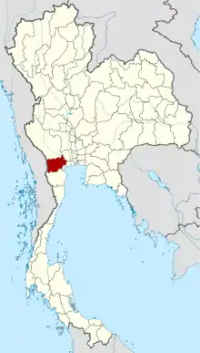 Map of Thailand highlighting Ratchaburi Province | |
| Country | Thailand |
| Capital | Ratchaburi |
| Government | |
| • Governor | Chayawut Chantarat (since Oct. 2017) |
| Area | |
| • Total | 5,196 km2 (2,006 sq mi) |
| Area rank | Ranked 42nd |
| Population (2018)[2] | |
| • Total | 873,518 |
| • Rank | Ranked 27th |
| • Density | 168/km2 (440/sq mi) |
| • Density rank | Ranked 21st |
| Human Achievement Index | |
| • HAI (2017) | 0.5713 "somewhat low" Ranked 53rd |
| Time zone | UTC+7 (ICT) |
| Postal code | 70xxx |
| Calling code | 032 |
| ISO 3166 code | TH-70 |
| Website | www |
Ratchaburi is 80 kilometres (50 mi) west of Bangkok and borders Myanmar to the west with the Tenasserim Hills as a natural border.[4] The Mae Klong flows through the centre of Ratchaburi town.
Geography
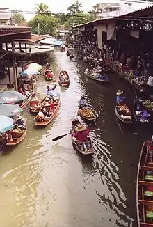
Ratchaburi Province is a medium-sized province with an area of about 5,196 square kilometres (2,006 sq mi). The eastern part of the province contains the flat river plains of the Mae Klong, crisscrossed by many khlongs. The most famous tourist spot in this area is the Damnoen Saduak Floating Market. The west of the province is more mountainous, and includes the Tenasserim Hills. As the mountains are made mostly of limestone, there are several caves containing stalactites. Some caves are inhabited by large colonies of bats, and it is an impressive sight when they swarm out in the evening to feed. Other caves like the Khao Bin are accessible for visitors.
The main river of the western part is the Phachi River. On the left bank of the Phachi is the Chaloem Phrakiat Thai Prachan National Park.
The area of Ratchaburi Province is divided into three parts. First, the border in the west which is shared with Myanmar and is about 60 kilometres (37 mi) long. The second contains the Tenasserim mountains and forests with an elevation of about 200–300 meters. The central area of the province is rich in wetlands due to river flow. Ratchaburi has important natural resources are forest which it have area about 38 percent of the province. Moreover, it has minerals such as tin, tantalum, feldspar, quartz, limestone, and marlstone.[5]
History
The history of the city of Ratchaburi dates back to the Dvaravati period, when it was an important city of the Mon Kingdom. Of the city of Khu Bua nearby only ruins remains. According to legend it dates back to the mythical Suvannabhumi Kingdom predating Dvaravati.
"Ratchaburi" means 'the land of the king'.[6] Ratchaburi dates back to ancient times and was important during the Dvaravati period. The city of Ratchburi is on the banks of the Mae Klong River and was a town of the Suvarnabhumi Kingdom.
Demographics
Hill tribes, mostly Karen living near the Myanmar border, make up about one percent of the population. Some Mon, Lawa, Lao, Chinese and Khmer minorities live in the province.[7]
Ratchaburi is 98.3 percent Buddhist.[8]:Table 4
Symbols
The provincial seal shows the royal sword above the royal sandals on a phan, as the name Ratchaburi means 'city of the king'. The name derives from the fact that King Rama I was born here. The provincial slogan is "Beautiful women of Photharam, beautiful women of Baan Pong, the city of earthenware jars, shadow plays at Wat Khanon, magnificent caves, floating market at Damnoen, bats, delicious Yii Sok fish". The provincial flower is the Pink Shower Tree (Cassia bakeriana), and the provincial tree is Wrightia pubescens.[9] Jullien's golden carp (Probarbus jullieni) is a provincial fish, same as neighbouring province Kanchanaburi. Since it is a fish that has good taste and had abounding in the Mae Klong River in the past, but is now in a critically endangered.[10]
Transportation
Rail
The main railway station in Ratchaburi is Ratchaburi Railway Station.
Health
Ratchaburi Hospital is the main hospital of the province.
Administrative divisions

Provincial government
The province is divided into 10 districts (amphoes).[11] The districts are further subdivided into 104 sub-districts (tambons) and 935 villages (mubans).
Local government
As of 26 November 2019 there are:[12] one Ratchaburi Provincial Administration Organisation (ongkan borihan suan changwat) and 34 municipal (thesaban) areas in the province. Ratchaburi, Ban Pong, Tha Pha and Photharam have town (thesaban mueang) status. Further 30 subdistrict municipalities (thesaban tambon). The non-municipal areas are administered by 77 Subdistrict Administrative Organisations - SAO (ongkan borihan suan tambon).[2]
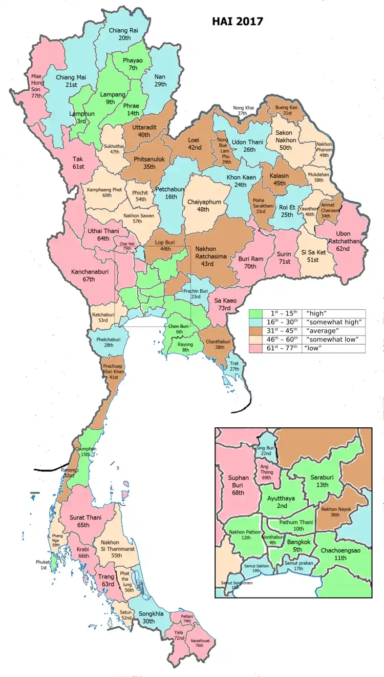
Human achievement index 2017
| Health | Education | Employment | Income |
| 49 | 22 | 52 | 23 |
| Housing | Family | Transport | Participation |
 |
 |
||
| 40 | 74 | 32 | 47 |
| Province Ratchaburi, with an HAI 2017 value of 0.5713 is "somewhat low", occupies place 53 in the ranking. | |||
Since 2003, United Nations Development Programme (UNDP) in Thailand has tracked progress on human development at sub-national level using the Human achievement index (HAI), a composite index covering all the eight key areas of human development. National Economic and Social Development Board (NESDB) has taken over this task since 2017.[3]
| Rank | Classification |
| 1 - 15 | "high" |
| 16 - 30 | "somewhat high" |
| 31 - 45 | "average" |
| 45 - 60 | "somewhat low" |
| 61 - 77 | "low" |
| Map with provinces and HAI 2017 rankings |
 |
Gallery
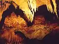 Khao Bin cave
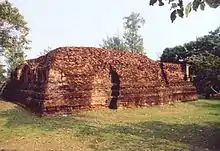 Wat Khlong, the largest ruin of Khu Bua
.jpg.webp) Bus terminal by Mae Klong, Ban Pong
Bus terminal by Mae Klong, Ban Pong.jpg.webp) Muban Chombueng Rajabhat University, a branch of Rajabhat University in Chom Bueng
Muban Chombueng Rajabhat University, a branch of Rajabhat University in Chom Bueng The Scenery Vintage Farm, resort of Suan Phueng
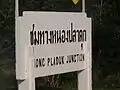 Sign of Nong Pladuk Junction Railway Station, the junction station of southern railway line and the starting point of death railway
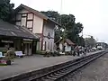 Chet Samian Railway Station, Photharam
_1.jpg.webp) Ratchaburi Shadow Puppet Museum in Wat Khanon, Photharam
Ratchaburi Shadow Puppet Museum in Wat Khanon, Photharam Chaloem Phrakiat Rama 9 Road, Ban Pong
.jpg.webp) Corridor of Ratchaburi National Museum
Corridor of Ratchaburi National Museum
Notes
Reports (data) from Thai government are "not copyrightable" (Public Domain), Copyright Act 2537 (1994), section 7.
References
- Advancing Human Development through the ASEAN Community, Thailand Human Development Report 2014, table 0:Basic Data (PDF) (Report). United Nations Development Programme (UNDP) Thailand. pp. 134–135. ISBN 978-974-680-368-7. Retrieved 17 January 2016, Data has been supplied by Land Development Department, Ministry of Agriculture and Cooperatives, at Wayback Machine.
- "รายงานสถิติจำนวนประชากรและบ้านประจำปี พ.ศ.2561" [Statistics, population and house statistics for the year 2018]. Registration Office Department of the Interior, Ministry of the Interior (in Thai). 31 December 2018. Retrieved 20 June 2019.
- Human achievement index 2017 by National Economic and Social Development Board (NESDB), pages 1-40, maps 1-9, retrieved 14 September 2019, ISBN 978-974-9769-33-1
- "Ratchaburi". Tourist Authority of Thailand (TAT). Archived from the original on 2015-05-20. Retrieved 28 May 2015.
- "Ratchaburi has important "natural resources"". Retrieved 4 Nov 2013.
- Choomjit, Y. (1994). History of Ratchaburi. Bangkok: Odienstore.
- Svasti, Pichaya (14 September 2017). "Time-travelling along the Mae Klong River". Bangkok Post. Retrieved 16 September 2017.
- "Population by religion, region and area, 2015" (PDF). National Statistical Office (NSO). Retrieved 2017-10-12.
- "Welcome to Ratchaburi Province, Thailand". Welcome to Ratchaburi Province, Thailand. Archived from the original on 2015-09-24. Retrieved 28 May 2015.
- "สัญลักษณ์ประจำจังหวัด" [Provincial symbols]. Canghwadrachburiffff (in Thai). Retrieved 2020-04-23.
- Ratchaburi is divided into "10 districts", Retrieved 4 Nov 2013, from http://www.encyclopediathai.org/sunthai/center/ratburi/ratburi.htm Archived 2012-12-15 at the Wayback Machine
- "Number of local government organizations by province". dla.go.th. Department of Local Administration (DLA). 26 November 2019. Retrieved 10 December 2019.
50 Ratchaburi: 1 PAO, 4 Town mun., 30 Subdistrict mun., 77 SAO.
External links
 Ratchaburi travel guide from Wikivoyage
- Ratchaburi Thai Only
- English Website of Province Archived May 6, 2008, at the Wayback Machine
- Ratchaburi Samanachan Archived March 31, 2012, at the Wayback Machine
| Wikimedia Commons has media related to Ratchaburi Province. |
Places adjacent to Ratchaburi Province | |
|---|---|
| Authority control |
|---|