Rico, Colorado
Rico is an incorporated small town in Dolores County, Colorado, United States. It was settled in 1879 as a silver mining center in the Pioneer Mining District; today it functions as a historic and tourism site. The population was 265 at the 2010 census,[8] up from 205 at the 2000 census. Its current form of government is that of a Home Rule Municipality.
Rico, Colorado | |
|---|---|
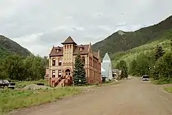 Rico Town Hall, listed on the National Register of Historic Places | |
| Motto(s): "A Slice of Paradise" | |
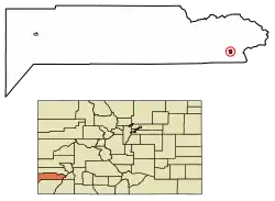 Location of Rico in Dolores County, Colorado. | |
| Coordinates: 37°41′32″N 108°1′51″W | |
| Country | |
| State | |
| County[1] | Dolores County |
| Incorporated (town) | February 25, 1880[2] |
| Government | |
| • Type | Home Rule Municipality[1] |
| • Mayor | Zach McManus[3] |
| Area | |
| • Total | 0.68 sq mi (1.76 km2) |
| • Land | 0.68 sq mi (1.76 km2) |
| • Water | 0.00 sq mi (0.00 km2) |
| Elevation | 8,825 ft (2,690 m) |
| Population (2010) | |
| • Total | 265 |
| • Estimate (2019)[6] | 231 |
| • Density | 340.71/sq mi (131.50/km2) |
| Time zone | UTC-7 (Mountain (MST)) |
| • Summer (DST) | UTC-6 (MDT) |
| ZIP code[7] | 81332 |
| Area code(s) | 970 |
| FIPS code | 08-64090 |
| GNIS feature ID | 0204670 |
| Website | ricocolorado |
Rico is a name derived from Spanish meaning "rich".[9]
Geography
Rico is located in eastern Dolores County at 37°41′32″N 108°1′51″W (37.692095, -108.030839),[10] in the valley of the Dolores River. Colorado State Highway 145 passes through the town as it follows the river, leading southwest 48 miles (77 km) to Cortez and northeast over Lizard Head Pass 27 miles (43 km) to Telluride.
According to the U.S. Census Bureau, the town of Rico has an area of 0.8 square miles (2.0 km2), all of it land.[8]
Climate
Rico experiences an alpine subarctic climate (Köppen climate classification Dfc) with long, cold, very snowy winters and short, cool summers due to the high altitude and high precipitation year-round due to orographic lift.
| Climate data for RICO, COLORADO | |||||||||||||
|---|---|---|---|---|---|---|---|---|---|---|---|---|---|
| Month | Jan | Feb | Mar | Apr | May | Jun | Jul | Aug | Sep | Oct | Nov | Dec | Year |
| Average high °F (°C) | 38.2 (3.4) |
39.9 (4.4) |
43.4 (6.3) |
50.5 (10.3) |
60.7 (15.9) |
70.6 (21.4) |
75.4 (24.1) |
73.2 (22.9) |
66.6 (19.2) |
58.2 (14.6) |
45.8 (7.7) |
39.5 (4.2) |
55.2 (12.9) |
| Average low °F (°C) | 5.2 (−14.9) |
7.6 (−13.6) |
13.4 (−10.3) |
20.9 (−6.2) |
28.2 (−2.1) |
33.7 (0.9) |
40.3 (4.6) |
39.6 (4.2) |
32.7 (0.4) |
24.8 (−4.0) |
14.8 (−9.6) |
7.2 (−13.8) |
22.4 (−5.4) |
| Average precipitation inches (mm) | 2.48 (63) |
2.15 (55) |
2.44 (62) |
1.81 (46) |
1.65 (42) |
1.31 (33) |
2.78 (71) |
2.91 (74) |
2.31 (59) |
2.13 (54) |
2.01 (51) |
2.27 (58) |
26.27 (667) |
| Average snowfall inches (cm) | 32.1 (82) |
26.5 (67) |
30.8 (78) |
18.5 (47) |
6.0 (15) |
0.1 (0.25) |
0 (0) |
0 (0) |
0.5 (1.3) |
7.6 (19) |
21.5 (55) |
26.2 (67) |
171 (430) |
| Source: The Western Regional Climate Center [11] | |||||||||||||
Demographics
| Historical population | |||
|---|---|---|---|
| Census | Pop. | %± | |
| 1880 | 894 | — | |
| 1890 | 1,134 | 26.8% | |
| 1900 | 811 | −28.5% | |
| 1910 | 368 | −54.6% | |
| 1920 | 326 | −11.4% | |
| 1930 | 447 | 37.1% | |
| 1940 | 388 | −13.2% | |
| 1950 | 212 | −45.4% | |
| 1960 | 353 | 66.5% | |
| 1970 | 275 | −22.1% | |
| 1980 | 76 | −72.4% | |
| 1990 | 92 | 21.1% | |
| 2000 | 205 | 122.8% | |
| 2010 | 265 | 29.3% | |
| 2019 (est.) | 231 | [6] | −12.8% |
| U.S. Decennial Census[12] | |||
As of the census[13] of 2000, there were 205 people, 104 households, and 47 families residing in the town. The population density was 268.0 people per square mile (102.8/km2). There were 197 housing units at an average density of 257.5 per square mile (98.8/km2). The racial makeup of the town was 92.68% White, 2.93% Native American, 1.95% Asian, 0.98% from other races, and 1.46% from two or more races. Hispanic or Latino of any race were 2.93% of the population.
There were 104 households, out of which 18.3% had children under the age of 18 living with them, 37.5% were married couples living together, 4.8% had a female householder with no husband present, and 54.8% were non-families. 39.4% of all households were made up of individuals, and 3.8% had someone living alone who was 65 years of age or older. The average household size was 1.97 and the average family size was 2.62.
In the town, the population was spread out, with 15.1% under the age of 18, 8.8% from 18 to 24, 50.7% from 25 to 44, 22.0% from 45 to 64, and 3.4% who were 65 years of age or older. The median age was 35 years. For every 100 females, there were 144.0 males. For every 100 females age 18 and over, there were 148.6 males.
The median income for a household in the town was $36,667, and the median income for a family was $55,625. Males had a median income of $31,806 versus $23,750 for females. The per capita income for the town was $21,920. About 13.2% of families and 13.8% of the population were below the poverty line, including 23.3% of those under the age of eighteen and none of those 65 or over.
Transportation
Rico is part of Colorado's Bustang network. It is on the Durango-Grand Junction Outrider line.[14]
See also
- Outline of Colorado
- State of Colorado
- Colorado cities and towns
- Colorado municipalities
- Colorado counties
- Colorado cities and towns
- San Juan Mountains
- San Juan Skyway
References
- "Active Colorado Municipalities". State of Colorado, Department of Local Affairs. Archived from the original on February 2, 2007. Retrieved 2007-09-01.
- "Colorado Municipal Incorporations". State of Colorado, Department of Personnel & Administration, Colorado State Archives. 2004-12-01. Retrieved 2007-09-02.
- "Town Hall". Rico Colorado. Retrieved December 12, 2018.
- "2019 U.S. Gazetteer Files". United States Census Bureau. Retrieved July 1, 2020.
- "US Board on Geographic Names". United States Geological Survey. 2007-10-25. Retrieved 2008-01-31.
- "Population and Housing Unit Estimates". United States Census Bureau. May 24, 2020. Retrieved May 27, 2020.
- "ZIP Code Lookup". United States Postal Service. Archived from the original (JavaScript/HTML) on December 14, 2006. Retrieved December 24, 2007.
- "Geographic Identifiers: 2010 Demographic Profile Data (G001): Rico town, Colorado". U.S. Census Bureau, American Factfinder. Retrieved October 15, 2015.
- Dawson, John Frank. Place names in Colorado: why 700 communities were so named, 150 of Spanish or Indian origin. Denver, CO: The J. Frank Dawson Publishing Co. p. 43.
- "US Gazetteer files: 2010, 2000, and 1990". United States Census Bureau. 2011-02-12. Retrieved 2011-04-23.
- "RICO, COLORADO (057017)". Retrieved December 18, 2015.
- "Census of Population and Housing". Census.gov. Retrieved June 4, 2015.
- "U.S. Census website". United States Census Bureau. Retrieved 2008-01-31.
- "Bustang Schedule". RideBustang. CDOT.
External links
| Wikimedia Commons has media related to Rico, Colorado. |
- Town of Rico official website
- CDOT map of the Town of Rico
- Marty Durlin, "A Rico Renaissance", High Country News, February 18, 2008
Municipalities and communities of Dolores County, Colorado, United States | ||
|---|---|---|
| Towns |  Map of Colorado highlighting Dolores County | |
| Unincorporated communities | ||
| ||

| Authority control |
|---|