Baillou
Baillou is a commune in the Loir-et-Cher department in central France. Notable buildings are the church of Saint-Jean-Baptiste and the Château de Baillou whose vast property spans most of the region.
Baillou | |
|---|---|
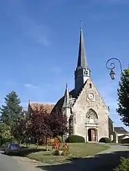 Church of Saint-Jean-Baptiste | |
 Coat of arms | |
Location of Baillou 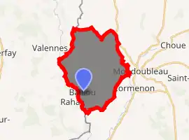
| |
 Baillou  Baillou | |
| Coordinates: 47°58′08″N 0°50′35″E | |
| Country | France |
| Region | Centre-Val de Loire |
| Department | Loir-et-Cher |
| Arrondissement | Vendôme |
| Canton | Le Perche |
| Intercommunality | Collines du Perche |
| Government | |
| • Mayor (2014–2020) | Jean-Luc Pelletier |
| Area 1 | 19.85 km2 (7.66 sq mi) |
| Population (2017-01-01)[1] | 226 |
| • Density | 11/km2 (29/sq mi) |
| Time zone | UTC+01:00 (CET) |
| • Summer (DST) | UTC+02:00 (CEST) |
| INSEE/Postal code | 41012 /41170 |
| Elevation | 88–166 m (289–545 ft) (avg. 152 m or 499 ft) |
| 1 French Land Register data, which excludes lakes, ponds, glaciers > 1 km2 (0.386 sq mi or 247 acres) and river estuaries. | |
The history of Baillou is inherently linked to the Baillou family, one of the oldest aristocratic families and landowners in Europe.
Population
| Year | Pop. | ±% |
|---|---|---|
| 1793 | 626 | — |
| 1800 | 609 | −2.7% |
| 1806 | 720 | +18.2% |
| 1821 | 628 | −12.8% |
| 1831 | 645 | +2.7% |
| 1836 | 633 | −1.9% |
| 1841 | 670 | +5.8% |
| 1846 | 640 | −4.5% |
| 1851 | 675 | +5.5% |
| 1856 | 649 | −3.9% |
| 1861 | 637 | −1.8% |
| 1866 | 582 | −8.6% |
| 1872 | 604 | +3.8% |
| 1876 | 605 | +0.2% |
| 1881 | 571 | −5.6% |
| 1886 | 581 | +1.8% |
| 1891 | 578 | −0.5% |
| 1896 | 568 | −1.7% |
| 1901 | 548 | −3.5% |
| 1906 | 562 | +2.6% |
| 1911 | 571 | +1.6% |
| 1921 | 529 | −7.4% |
| 1926 | 485 | −8.3% |
| 1931 | 508 | +4.7% |
| 1936 | 501 | −1.4% |
| 1946 | 521 | +4.0% |
| 1954 | 450 | −13.6% |
| 1962 | 410 | −8.9% |
| 1968 | 354 | −13.7% |
| 1975 | 276 | −22.0% |
| 1982 | 250 | −9.4% |
| 1990 | 230 | −8.0% |
| 1999 | 229 | −0.4% |
| 2006 | 244 | +6.6% |
| 2009 | 248 | +1.6% |
References
- "Populations légales 2017". INSEE. Retrieved 6 January 2020.
| Wikimedia Commons has media related to Baillou. |
| Authority control |
|---|
This article is issued from Wikipedia. The text is licensed under Creative Commons - Attribution - Sharealike. Additional terms may apply for the media files.