Vineuil, Loir-et-Cher
Vineuil (French pronunciation: [vinœj]) is a commune near Blois, in the Loir-et-Cher department in Centre Region, France.
Vineuil | |
|---|---|
Commune | |
 Town hall | |
.svg.png.webp) Coat of arms | |
Location of Vineuil 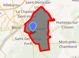
| |
 Vineuil  Vineuil | |
| Coordinates: 47°34′53″N 1°22′24″E | |
| Country | France |
| Region | Centre-Val de Loire |
| Department | Loir-et-Cher |
| Arrondissement | Blois |
| Canton | Vineuil |
| Intercommunality | Communauté d'agglomération de Blois |
| Government | |
| • Mayor (2014–2020) | François Fromet |
| Area 1 | 22.34 km2 (8.63 sq mi) |
| Population (2017-01-01)[1] | 7,815 |
| • Density | 350/km2 (910/sq mi) |
| Time zone | UTC+01:00 (CET) |
| • Summer (DST) | UTC+02:00 (CEST) |
| INSEE/Postal code | 41295 /41350 |
| Elevation | 68–100 m (223–328 ft) (avg. 84 m or 276 ft) |
| 1 French Land Register data, which excludes lakes, ponds, glaciers > 1 km2 (0.386 sq mi or 247 acres) and river estuaries. | |
Geography
The commune is traversed by the Cosson river.
Population
|
|
References
- "Populations légales 2017". INSEE. Retrieved 6 January 2020.
| Wikimedia Commons has media related to Vineuil (Loir-et-Cher). |
| Authority control |
|
|---|
This article is issued from Wikipedia. The text is licensed under Creative Commons - Attribution - Sharealike. Additional terms may apply for the media files.