Selles-Saint-Denis
Selles-Saint-Denis is a commune in the Loir-et-Cher department of central France.
Selles-Saint-Denis | |
|---|---|
Commune | |
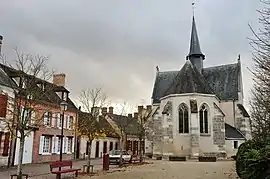 Chapel of Saint-Genouph | |
Location of Selles-Saint-Denis 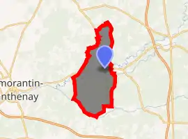
| |
 Selles-Saint-Denis  Selles-Saint-Denis | |
| Coordinates: 47°23′12″N 1°55′25″E | |
| Country | France |
| Region | Centre-Val de Loire |
| Department | Loir-et-Cher |
| Arrondissement | Romorantin-Lanthenay |
| Canton | La Sologne |
| Intercommunality | La Sologne des rivières |
| Government | |
| • Mayor (2014–2020) | Pierre Maurice |
| Area 1 | 50.98 km2 (19.68 sq mi) |
| Population (2017-01-01)[1] | 1,337 |
| • Density | 26/km2 (68/sq mi) |
| Time zone | UTC+01:00 (CET) |
| • Summer (DST) | UTC+02:00 (CEST) |
| INSEE/Postal code | 41241 /41300 |
| Elevation | 89–129 m (292–423 ft) |
| 1 French Land Register data, which excludes lakes, ponds, glaciers > 1 km2 (0.386 sq mi or 247 acres) and river estuaries. | |
Geography
The river Rère flows west through the southern part of the commune.
Population
|
|
References
- "Populations légales 2017". INSEE. Retrieved 6 January 2020.
| Wikimedia Commons has media related to Selles-Saint-Denis. |
| Authority control |
|---|
This article is issued from Wikipedia. The text is licensed under Creative Commons - Attribution - Sharealike. Additional terms may apply for the media files.