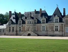
Tour-en-Sologne
Tour-en-Sologne is a commune of the Loir-et-Cher department in central France.
Tour-en-Sologne | |
|---|---|
Commune | |
 | |
.svg.png.webp) Coat of arms | |
Location of Tour-en-Sologne 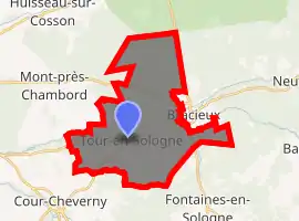
| |
 Tour-en-Sologne  Tour-en-Sologne | |
| Coordinates: 47°32′23″N 1°30′03″E | |
| Country | France |
| Region | Centre-Val de Loire |
| Department | Loir-et-Cher |
| Arrondissement | Blois |
| Canton | Chambord |
| Intercommunality | Pays de Chambord |
| Government | |
| • Mayor (2014–2020) | Robert Hutteau |
| Area 1 | 26.34 km2 (10.17 sq mi) |
| Population (2017-01-01)[1] | 1,117 |
| • Density | 42/km2 (110/sq mi) |
| Time zone | UTC+01:00 (CET) |
| • Summer (DST) | UTC+02:00 (CEST) |
| INSEE/Postal code | 41262 /41250 |
| Elevation | 72–123 m (236–404 ft) (avg. 85 m or 279 ft) |
| 1 French Land Register data, which excludes lakes, ponds, glaciers > 1 km2 (0.386 sq mi or 247 acres) and river estuaries. | |
Population
|
|
References
- "Populations légales 2017". INSEE. Retrieved 6 January 2020.
External links
| Wikimedia Commons has media related to Tour-en-Sologne. |
| Authority control |
|---|
This article is issued from Wikipedia. The text is licensed under Creative Commons - Attribution - Sharealike. Additional terms may apply for the media files.