Sougé, Loir-et-Cher
Sougé is a commune of the Loir-et-Cher department in central France.
Sougé | |
|---|---|
Commune | |
 | |
.svg.png.webp) Coat of arms | |
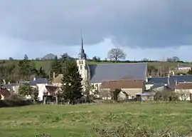
Location of Sougé 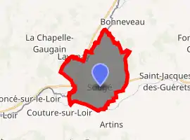
| |
 Sougé  Sougé | |
| Coordinates: 47°46′16″N 0°43′43″E | |
| Country | France |
| Region | Centre-Val de Loire |
| Department | Loir-et-Cher |
| Arrondissement | Vendôme |
| Canton | Le Perche |
| Intercommunality | Coteaux de la Braye |
| Government | |
| • Mayor (2014–2020) | Bernard Bonhomme |
| Area 1 | 16.88 km2 (6.52 sq mi) |
| Population (2017-01-01)[1] | 479 |
| • Density | 28/km2 (73/sq mi) |
| Time zone | UTC+01:00 (CET) |
| • Summer (DST) | UTC+02:00 (CEST) |
| INSEE/Postal code | 41250 /41800 |
| Elevation | 56–147 m (184–482 ft) (avg. 62 m or 203 ft) |
| 1 French Land Register data, which excludes lakes, ponds, glaciers > 1 km2 (0.386 sq mi or 247 acres) and river estuaries. | |
It is situated on the Loir River in the Loir Valley, in the Centre-Val de Loire region of France. The nearest town of more than 40,000 inhabitants is Tours.
History
In the time of the Romans, Sougé had a special importance because of his Roman's camp, called "Camp of Cesar" in the country. Today the fortifications are not visible any longer, but they were visible in the last century.
Geography
Sougé is a village in the department of Loir-et-Cher, there is 437 inhabitants. The village of Sougé is near the village of Couture-sur-Loir (the village of Pierre de Ronsard). The village of Sougé is near the town of Montoire-sur-le-Loir.
Name
Sougé was called Silviacus (3rd and 8th century), then Selgiacus (11th century), Sugeium in 1216, Sougeium in the 13th century, paroisse des Roches de Sougé in 1595, Sougé-sur-Loir in 1675, Sougé-sur-Braye after the French Revolution, and now Sougé.
Population
|
|
Sights
The spacious church of St. Quintin has a barrel-vaulted roof and early twentieth century glass depicting amongst other themes Pope Leo XIII. There are traces of Renaissance architecture along the main (and almost only) street. The village cemetery contains Commonwealth graves.
See also
Communes near Sougé:
References
- "Populations légales 2017". INSEE. Retrieved 6 January 2020.
External links
- Communalty of Sougé
- Louis Richard an inhabitant of Sougé during the first world war
- A site on Sougé
- Tourism in Loir Valley
| Wikimedia Commons has media related to Sougé (Loir-et-Cher). |
| Authority control |
|
|---|