La Ferté-Saint-Cyr
La Ferté-Saint-Cyr (French: [la fɛʁte sɛ̃ siʁ]) is a commune near Blois, in the Loir-et-Cher department in Centre-Val de Loire, France.
La Ferté-Saint-Cyr | |
|---|---|
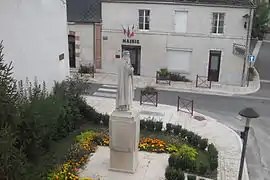 Statue and town hall | |
Location of La Ferté-Saint-Cyr 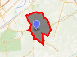
| |
 La Ferté-Saint-Cyr  La Ferté-Saint-Cyr | |
| Coordinates: 47°39′24″N 1°40′30″E | |
| Country | France |
| Region | Centre-Val de Loire |
| Department | Loir-et-Cher |
| Arrondissement | Blois |
| Canton | Chambord |
| Intercommunality | Grand Chambord |
| Government | |
| • Mayor (2020–2026) | Anne-Marie Thomas |
| Area 1 | 57.93 km2 (22.37 sq mi) |
| Population (2017-01-01)[1] | 1,056 |
| • Density | 18/km2 (47/sq mi) |
| Time zone | UTC+01:00 (CET) |
| • Summer (DST) | UTC+02:00 (CEST) |
| INSEE/Postal code | 41085 /41220 |
| Elevation | 78–131 m (256–430 ft) (avg. 86 m or 282 ft) |
| 1 French Land Register data, which excludes lakes, ponds, glaciers > 1 km2 (0.386 sq mi or 247 acres) and river estuaries. | |
Geography
The commune is traversed by the Cosson river.
Population
|
|
References
- "Populations légales 2017". INSEE. Retrieved 6 January 2020.
| Wikimedia Commons has media related to La Ferté-Saint-Cyr. |
| Authority control |
|---|
This article is issued from Wikipedia. The text is licensed under Creative Commons - Attribution - Sharealike. Additional terms may apply for the media files.