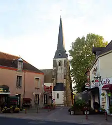
Châtres-sur-Cher
Châtres-sur-Cher is a commune in the Loir-et-Cher department in central France.
Châtres-sur-Cher | |
|---|---|
 | |
 Coat of arms | |
Location of Châtres-sur-Cher 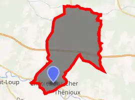
| |
 Châtres-sur-Cher  Châtres-sur-Cher | |
| Coordinates: 47°15′57″N 1°54′25″E | |
| Country | France |
| Region | Centre-Val de Loire |
| Department | Loir-et-Cher |
| Arrondissement | Romorantin-Lanthenay |
| Canton | Selles-sur-Cher |
| Intercommunality | Romorantinais |
| Government | |
| • Mayor (2014–2020) | Sylvie Doucet-Lauverjat |
| Area 1 | 35.33 km2 (13.64 sq mi) |
| Population (2017-01-01)[1] | 1,097 |
| • Density | 31/km2 (80/sq mi) |
| Time zone | UTC+01:00 (CET) |
| • Summer (DST) | UTC+02:00 (CEST) |
| INSEE/Postal code | 41044 /41320 |
| Elevation | 87–157 m (285–515 ft) (avg. 103 m or 338 ft) |
| 1 French Land Register data, which excludes lakes, ponds, glaciers > 1 km2 (0.386 sq mi or 247 acres) and river estuaries. | |
Geography
The Rère forms the commune's northern border.
The Cher forms part of the commune's southern border.
Population
| Year | Pop. | ±% |
|---|---|---|
| 1793 | 777 | — |
| 1806 | 791 | +1.8% |
| 1821 | 814 | +2.9% |
| 1831 | 916 | +12.5% |
| 1841 | 965 | +5.3% |
| 1851 | 1,066 | +10.5% |
| 1861 | 1,088 | +2.1% |
| 1872 | 1,163 | +6.9% |
| 1881 | 1,220 | +4.9% |
| 1891 | 1,280 | +4.9% |
| 1901 | 1,300 | +1.6% |
| 1911 | 1,415 | +8.8% |
| 1921 | 1,308 | −7.6% |
| 1931 | 1,362 | +4.1% |
| 1946 | 1,208 | −11.3% |
| 1954 | 1,214 | +0.5% |
| 1962 | 1,144 | −5.8% |
| 1968 | 1,059 | −7.4% |
| 1975 | 1,009 | −4.7% |
| 1982 | 1,110 | +10.0% |
| 1990 | 1,074 | −3.2% |
| 1999 | 1,129 | +5.1% |
| 2008 | 1,071 | −5.1% |
| 2013 | 1,110 | +3.6% |
References
- "Populations légales 2017". INSEE. Retrieved 6 January 2020.
| Wikimedia Commons has media related to Châtres-sur-Cher. |
| Authority control |
|---|
This article is issued from Wikipedia. The text is licensed under Creative Commons - Attribution - Sharealike. Additional terms may apply for the media files.