Sargé-sur-Braye
Sargé-sur-Braye is a commune in the Loir-et-Cher department in central France.
Sargé-sur-Braye | |
|---|---|
Commune | |
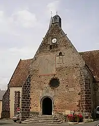 Church of Saint-Cyr | |
.svg.png.webp) Coat of arms | |
Location of Sargé-sur-Braye 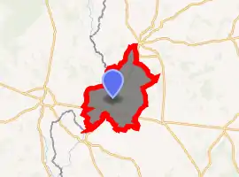
| |
 Sargé-sur-Braye  Sargé-sur-Braye | |
| Coordinates: 47°55′28″N 0°51′14″E | |
| Country | France |
| Region | Centre-Val de Loire |
| Department | Loir-et-Cher |
| Arrondissement | Vendôme |
| Canton | Le Perche |
| Intercommunality | Collines du Perche |
| Government | |
| • Mayor (2014–2020) | Jean Léger |
| Area 1 | 42.61 km2 (16.45 sq mi) |
| Population (2017-01-01)[1] | 1,041 |
| • Density | 24/km2 (63/sq mi) |
| Time zone | UTC+01:00 (CET) |
| • Summer (DST) | UTC+02:00 (CEST) |
| INSEE/Postal code | 41235 /41170 |
| Elevation | 78–202 m (256–663 ft) (avg. 90 m or 300 ft) |
| 1 French Land Register data, which excludes lakes, ponds, glaciers > 1 km2 (0.386 sq mi or 247 acres) and river estuaries. | |
Geography
The commune is bathed by the Braye and the Grenne rivers, which join here before leading as the Braye to the Loir. The town is a part of the canton of Le Perche. It is bordered to the north by Cormenon, to the south by Savigny-sur-Braye, to the east by Épuisay and to the west by Saint-Calais.
History
Between 29 January and 8 February 1939, more than 3,100 Spanish refugees fleeing the collapse of the Spanish Republic under Franco, arrived in Loir-et-Cher. Faced with a lack of buildings to welcome them (the stud farm at Selles-sur-Cher had been used), 47 villages provide accommodation,[2] including Sargé-sur-Braye.[3] The refugees, essentially women and children, were subjected to a strict quarantine and vaccinated. Mail was limited. Supplies, though lacking variety and cooked the French way, were, however, assured.[4] In the spring and summer, the refugees were regrouped at Bois-Brûlé (commune of Boisseau).[5]
Population
| Year | Pop. | ±% |
|---|---|---|
| 1793 | 1,534 | — |
| 1806 | 1,691 | +10.2% |
| 1821 | 1,690 | −0.1% |
| 1831 | 1,777 | +5.1% |
| 1841 | 1,734 | −2.4% |
| 1851 | 1,598 | −7.8% |
| 1861 | 1,550 | −3.0% |
| 1872 | 1,508 | −2.7% |
| 1881 | 1,745 | +15.7% |
| 1891 | 1,625 | −6.9% |
| 1901 | 1,702 | +4.7% |
| 1911 | 1,756 | +3.2% |
| 1921 | 1,536 | −12.5% |
| 1931 | 1,393 | −9.3% |
| 1946 | 1,235 | −11.3% |
| 1954 | 1,120 | −9.3% |
| 1962 | 1,144 | +2.1% |
| 1968 | 991 | −13.4% |
| 1975 | 911 | −8.1% |
| 1982 | 974 | +6.9% |
| 1990 | 988 | +1.4% |
| 1999 | 974 | −1.4% |
| 2006 | 934 | −4.1% |
| 2015 | 1,054 | +12.8% |
Sights
_%C3%89glise_Saint-Martin_01.JPG.webp)
- Église Saint-Martin. This church been listed since 1958 as a historic monument by the French Ministry of Culture. Dating originally from the 10th century, its present form is from 1549. There are traces of 14th century painted murals.[6]
- Église Saint-Cyr, and its jacquemart.
- Château des Radrets has been listed since 1977 as a monument historique. Parts of it date back to the 15th century; it was extensively altered in the 18th.[7]
- Château de Montmarin has been listed since 1986 as a monument historique. Originally 17th century, it was altered in the 18th and 19th.[8]
- Château du Fief Corbin
- Roussard quarry
References
- "Populations légales 2017". INSEE. Retrieved 6 January 2020.
- Jeanine Sodigné-Loustau, "L'accueil des réfugiés civils espagnols de 1936 à 1940. Un exemple : la région Centre", Matériaux pour l'histoire de notre temps. 1996, no 44. p. 43.
- Jeanine Sodigné-Loustau, op cit, p. 47.
- Jeanine Sodigné-Loustau, op cit, p. 43-44.
- Jeanine Sodigné-Loustau, op cit, p. 46.
- Base Mérimée: Eglise Saint-Martin, Ministère français de la Culture. (in French)
- Base Mérimée: Château des Radrets, Ministère français de la Culture. (in French)
- Base Mérimée: PA00098590, Ministère français de la Culture. (in French)
External links
- Base Mérimée: Eglise Saint-Martin, Ministère français de la Culture. (in French)
- Base Mérimée: Château des Radrets, Ministère français de la Culture. (in French)
- Base Mérimée: Château de Montmarin, Ministère français de la Culture. (in French)
| Wikimedia Commons has media related to Sargé-sur-Braye. |
| Authority control |
|---|