Binas, Loir-et-Cher
Binas is a commune in the Loir-et-Cher department in central France.
Binas | |
|---|---|
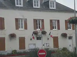 Town hall | |
.svg.png.webp) Coat of arms | |
Location of Binas 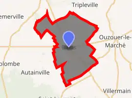
| |
 Binas  Binas | |
| Coordinates: 47°54′15″N 1°27′48″E | |
| Country | France |
| Region | Centre-Val de Loire |
| Department | Loir-et-Cher |
| Arrondissement | Blois |
| Canton | La Beauce |
| Intercommunality | Beauce oratorienne |
| Government | |
| • Mayor (2014–2020) | Solange Vallée |
| Area 1 | 26.38 km2 (10.19 sq mi) |
| Population | 686 |
| • Density | 26/km2 (67/sq mi) |
| Time zone | UTC+01:00 (CET) |
| • Summer (DST) | UTC+02:00 (CEST) |
| INSEE/Postal code | 41017 /41240 |
| Elevation | 120–133 m (394–436 ft) (avg. 128 m or 420 ft) |
| 1 French Land Register data, which excludes lakes, ponds, glaciers > 1 km2 (0.386 sq mi or 247 acres) and river estuaries. | |
Population
|
| ||||||||||||||||||||||||||||||||||||||||||||||||||||||||||||||||||||||||||||||||||||||||||||||||||||||||||||||||||
| Source: EHESS[2] and INSEE[3] | |||||||||||||||||||||||||||||||||||||||||||||||||||||||||||||||||||||||||||||||||||||||||||||||||||||||||||||||||||
References
- "Populations légales 2017". INSEE. Retrieved 6 January 2020.
- Des villages de Cassini aux communes d'aujourd'hui: Commune data sheet Binas, EHESS. (in French)
- Population en historique depuis 1968, INSEE
| Wikimedia Commons has media related to Binas. |
| Authority control |
|
|---|
This article is issued from Wikipedia. The text is licensed under Creative Commons - Attribution - Sharealike. Additional terms may apply for the media files.