Pruniers-en-Sologne
Pruniers-en-Sologne is a commune in the Loir-et-Cher department of central France.
Pruniers-en-Sologne | |
|---|---|
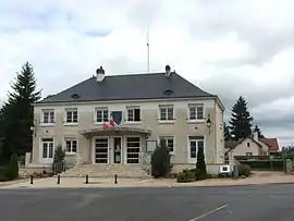 Town hall | |
.svg.png.webp) Coat of arms | |
Location of Pruniers-en-Sologne 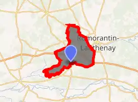
| |
 Pruniers-en-Sologne  Pruniers-en-Sologne | |
| Coordinates: 47°19′25″N 1°40′19″E | |
| Country | France |
| Region | Centre-Val de Loire |
| Department | Loir-et-Cher |
| Arrondissement | Romorantin-Lanthenay |
| Canton | Selles-sur-Cher |
| Intercommunality | Romorantinais |
| Government | |
| • Mayor (2014–2020) | Claude Thérèze |
| Area 1 | 43.84 km2 (16.93 sq mi) |
| Population (2017-01-01)[1] | 2,388 |
| • Density | 54/km2 (140/sq mi) |
| Time zone | UTC+01:00 (CET) |
| • Summer (DST) | UTC+02:00 (CEST) |
| INSEE/Postal code | 41185 /41200 |
| Elevation | 74–111 m (243–364 ft) |
| 1 French Land Register data, which excludes lakes, ponds, glaciers > 1 km2 (0.386 sq mi or 247 acres) and river estuaries. | |
Population
| Year | Pop. | ±% |
|---|---|---|
| 1793 | 531 | — |
| 1806 | 623 | +17.3% |
| 1821 | 656 | +5.3% |
| 1831 | 600 | −8.5% |
| 1841 | 604 | +0.7% |
| 1851 | 732 | +21.2% |
| 1861 | 822 | +12.3% |
| 1872 | 823 | +0.1% |
| 1881 | 900 | +9.4% |
| 1891 | 975 | +8.3% |
| 1901 | 1,013 | +3.9% |
| 1911 | 1,054 | +4.0% |
| 1921 | 1,326 | +25.8% |
| 1931 | 989 | −25.4% |
| 1946 | 963 | −2.6% |
| 1954 | 1,007 | +4.6% |
| 1962 | 988 | −1.9% |
| 1968 | 890 | −9.9% |
| 1975 | 1,102 | +23.8% |
| 1982 | 1,556 | +41.2% |
| 1990 | 1,992 | +28.0% |
| 1999 | 2,128 | +6.8% |
| 2004 | 2,249 | +5.7% |
| 2014 | 2,418 | +7.5% |
References
- "Populations légales 2017". INSEE. Retrieved 6 January 2020.
| Wikimedia Commons has media related to Pruniers-en-Sologne. |
| Authority control |
|---|
This article is issued from Wikipedia. The text is licensed under Creative Commons - Attribution - Sharealike. Additional terms may apply for the media files.